CANAL NEWS
Published by the Middlesex Canal Association
Billerica, Massachusetts
Vol. 1, No. 2 January, 1964
CANAL NEWS
Published by the Middlesex Canal Association
Billerica, Massachusetts
Vol. 1, No. 2 January, 1964
F. L. Lawsen, Jr. |
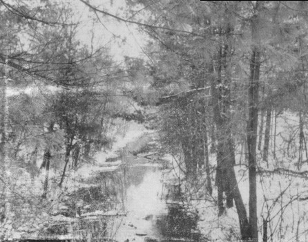
The Canal in Winter
In this Issue.....
A Description of the Middlesex Canal
by Charles Frederic Morey
MIDDLESEX CANAL
The Middlesex Canal found its source at its summit level in Billerica, Mass. Work began about 1794 and the canal was operated from 1804 to 1853.
With the exception of a small amount drawn from Horn Pond, water came from the Concord River at Billerica Mill Pond, feeding the course to the southward to Charles River, 22 miles distant, and to the northward over a distance of nearly 6 miles to Merrimack River.
The summit was 107 feet above the tide water at Boston and 27 feet above the Merrimack. The breadth was 20 feet at bottom and 30½ feet at the water line. The trough was built to carry a depth of 3½ feet; but owing to silting after completion of the Canal the water was seldom more than three feet deep.
General specifications, in the early contracts for construction, were varied over short distances in several locations where the presence of solid ledges of rock led to a diminution of the width in some cases to 14 feet.
Occasional basins of much greater extent furnished landing places or havens where boats could congregate. The banks, 1 foot above the water line, were 10 feet wide in general on the towing path side and 5 feet wide on the other. A specification that the slopes of all banks should be 33 degrees was contained in the general plan outlined by the projectors and was embodied in the contract.
There were 20 locks, 8 aqueducts and 48 bridges, as well as the necessary safety gates, culverts, sluiceways, and waste weirs. The 20 locks included 2 tide locks on the Charles and 2 guard locks on the Concord. The latter, by regulating in part the flow of water into the canal helped to provide against the danger to the banks from variations in the level of Concord River. Locks were 10 to 12 feet wide and, though of slightly different lengths, all were large enough to accommodate Canal-Boats fully 75 feet long. The highest single lift was 10 feet about and the average lift between 7 and 8 feet. Some of the locks were of stone, others of wood. In the latter, the wooden side walls were enclosed between walls of rough masonry formed a few feet back of the timber work. The timber constituted a compact box for the water; and the masonry, a retaining wall for the earth. Struts of wood braced the two walls apart.
The head of the line was on the Merrimack at Middlesex Village, about one mile above the present dam at Lowell. There the entrance was formed by a nearly semi-circular basin, measuring about 200 feet along the shore of the River and extending back from the River about 100 feet. It was about 5 feet below the surface of the Merrimack at low water and about 10 or 12 feet below the natural surface of the earth.
The basin led to a flight of 3 locks of durable stone masonry set in trass mortar, which were the first and best built locks on the Canal. Through these, rafts and luggage boats were lifted to the summit level. The yards and tracks of the B. & M. R.R. now cover the ground formerly occupied by the locks.
Passing under the main street at Middlesex Village, the Canal crossed Black Brook in a wooden aqueduct near the site occupied, when the Canal was completed, by a glass factory.
The Aqueduct, with abutments 110 feet apart, was supported by 10 wooden piers on stone foundations. Its trough, about 10 feet above the stream below, was made of timber and plank, with the timber framed together by tenons and mortises and strengthened by braces. Had the construction been with knees and bolts, after the fashion of ship building it would, doubtless, have been more durable. Continuing across what is now Chelmsford Street and then at right angles to the present track of the Lowell Framingham R.R. the Canal next traversed the Great Swamp, the location of a large portion of the two necessary miles of embankment between the Merrimack and Concord Rivers. Carried over River Meadow Brook or Hale's Brook in a small aqueduct, it continued to Billerica Mills, where a stone guard lock, excavated in a ledge of rock, formed the entrance into Concord River Mill Pond.
Remains of the guard lock may now be traced in the yard of the Talbot Mills.
Some rods below the line of the Canal at this point, a dam about 150 feet long and 8 feet high was thrown across Concord River creating the Mill Pond out of which water flowed to supply both arms of the Canal.
The water feeding the longer line toward Boston passed through a horizontal aperture of 6 feet by 1 foot, with a head of 2 feet of water above the upper part of the aperture. Waste gates in the dam made it possible to regulate to some extent the height of the water. The fountain head of the Canal was crossed by a floating Tow Path of which a section could be removed, to permit logs, timber, or driftwood coming down Concord River to pass through to several saw mills below. The trunk of the Canal left Concord River by another stone guard lock and pushed on through about one half mile of deep cutting. Some 800 feet of this was blasted through hard, granite rock. Today the Billerica Car Shops of the B. & M. R.R. are set squarely in its former path, obliterating all traces; but beyond them for nearly a mile the Canal is still found in almost navigable form. Continuing from here the Canal, today a dry ditch, reached the site of the famous Shawsheen Aqueduct, which carried it some 30 to 35 feet above the Shawsheen River. About 188 feet in length, the Aqueduct rested on 2 abutments and 3 or more central stone piers all laid without mortar, with a wooden brace or modest type of pier between each outside stone pier and the adjacent abutment. Large horizontal timbers, embedded between the piers at suitable distances, served as supports to the lower ends of the Aqueduct's braces. From each end of the Aqueduct an embankment 30 to 35 feet high ran a distance of several hundred feet. As freight and packet boats could only proceed singly over the river, basins on either side allowed them to congregate while awaiting passage. From its height and from the general nature of the surrounding low land, the Shawsheen Aqueduct was one of the imposing sights of the Canal.
A half mile south of the Shawsheen came the first drop from the summit level through Nichols' Lock. Slight remains can be identified today at Nichols Street.
A mile and one half more, fairly evenly divided between excavation and embankment, and continuing over Lubber Brook, a small Aqueduct known as Sinking Meadow Aqueduct, brought the Canal to Gillis or Jacques Lock, the second descent toward Boston Harbor. At the Sinking Meadow, an embankment of some 30 rods was originally carried across a morass, with sub-soil of decayed vegetation. The earth and gravel brought on continued for some years to sink gradually into the marsh. Estimates of the depth to which the embankment sank vary from 38 to 60 feet. The wall on the east was the first to hold firm: that on the west also ceased to settle, but continued for a time to spread. Material was carried on and impacted until the banks were consolidated. A house has been built on the ground of the second descending lock, the garden occupying the site of the basin.
The Old Canal Tavern still stands, recently occupied by tenants, one of whom was a descendant of a Tavern Keeper at Gillis Lock.
The tow path from here to Wilmington became the ground bed of a trolley line, which eventually reached a state of decay comparable to that of the Canal.
Passing from Gillis Lock over a small Aqueduct the Canal encountered more obstacles some two miles beyond, near the site of the former Wilmington Poor Farm. Here an embankment, some 80 rods long and 25 feet high, the top of the towing path, was thrown across Maple Meadow, and an Aqueduct constructed over Maple Meadow Brook, a source of the Ipswich River. To avoid further passage through this treacherous meadow, the Canal was turned sharply making an abrupt bend which came to be called the "Ox-Bow."
The former entrance to the town of Woburn was reached a mile farther South, the route skirting or crossing the present State Highway, then paralleling or merging with the roadbed of the Woburn branch of the B. & M. R.R. through No. Woburn Central Square; and as far as the grounds of the present Woburn Public Library.
A fairly high embankment, originally, built during the winter over a sinking meadow in Woburn, caused some difficulty. By the end of the Spring thaw, it had settled so that its top was level with the natural height of the ground. Another embankment was raised upon it. In North Woburn the line runs beside the Baldwin Mansion, built in part in 1660, before which in the Public Square stands a statue of Loammi Baldwin, the Engineer of the Canal. One of the chief engineering features of the Middlesex Canal was reached after its passage beyond the site of the present Woburn Public Library. Here 3 sets of double locks, called Stoddard or Horn Pond Locks, accomplished a descent of 50 feet. The middle set of locks was separated from the set above and the one below by basinlike widenings to equalize the draft of water by locking.
High above Horn Pond stood a spacious, much frequented Canal Tavern.
Stone Lock, a nine foot drop, was situated about ½ mile further on, at the crossing of Horn Pond Brook. Water was here taken in from Horn Pond, the only source in addition to Concord River. A mile and a half below, just north of the Aberjona River, then called Symmes River, were Gardners' Locks which were double. The bed of Symmes River formerly occupied part of the Upper Basin of Mystic Lakes; the basin did not then exist.
An Aqueduct with abutments 127 feet apart and with 3 intervening stone piers effected the crossing of Symmes River. The remains of piers or abutments are still visible at the point where the Aberjona River connects the Mystic Lakes with the Upper Basin, not far from the Bronze Tablet, with its Historical Record of the Canal, erected on Mystic Parkway.
Running close along the shore of the Mystic Lakes, the line passed through the estate of Peter C. Brooks, where an elliptical stone arch of admirable proportions carried a farm road over the Canal. Farther south, about a mile and one half, came Gilson's Lock, followed by an aqueduct, 135 feet long, borne over Mystic River by 2 stone abutments and 3 stone piers. Each pier and abutment was 12 feet high, 20 feet long about 6 feet in width. The surface of the water in the Aqueduct was about 10 feet above that in the river at high tide. One mile beyond, the Medford Branch Canal, about one quarter mile long, with a Lock and Basin at the upper end and a Lock at the lower, connected the Mystic River with the Main Canal. On the banks of this river after the coming of the Middlesex Canal grew excellent shipyards which made the name of Medford famous in the Ports of the World; and "Medford Built" became synonymous with the best of finished workmanship. From the crossing of Mystic River to the end of the line, practically all traces of the Canal have disappeared. It passed through the land now occupied by the Rivering Mills of the American Woolen Company, then under the present railroad tracks, along West St.; parallel to or in Summer Street and wound a tortuous course, avoiding the hills on the west and Mystic Marshes on the east. A little damp pool near Hancock Ave., in the rear of a brick building said to have been a hat factory when the Canal was in operation, is the last vestige that remains in this populous section.
Running along the westerly part of the old Mystic Trotting Park the Canal came out at the coal pocket on the Mystic River near the Somerville Town line, turning inland once more at the western end of Broadway Park, where a stone monument marks its former path. It then curved around the base of Mt. Benedict, Ploughed Hill of Revolutionary Times. From here to Dorrance Street in Charlestown the route passes through congested districts. Crossing the old Medford Turnpike and the rails of the B. & M. it finally passes up the spur track of a Lumber Company and meets the high brick wall around the Sullivan Square terminal of the Boston Elevated, which effectually stops further investigation. Near this was the Malden Road Lock and some 600 feet further a lock, 114 feet long, leading to the Mill Pond. Still another lock, with double gates that might be worked in either direction according to the state of the tide, let Canal Boats from the Mill Pond into Charles River. Today the site of this Mill Pond is dry land covered with streets and buildings.
Once in Charles River, the boats might be poled, sculled or sailed to any part of Boston; but a short branch Canal penetrated the City at the present site of the B. & M. R.R. Station. Entering at the river front, it crossed Causeway Street and passed inward three City blocks, running between Haverhill and Canal Streets and ending at Haymarket Square.
The author of the article, Charles Frederic Morey, of Billerica, died in 1949. He was a descendant of Samuel Morey, the inventor of the steamboat. A lifelong enthusiast of the Canal, he knew its entire course. His grandfather had been engaged in the wood business in Tewksbury, and used to deliver fire-wood to Boston by canal boat. This article was written in the late 1930's, at a time when the State of the Canal was much as it is at present, except for the few homes that are now being built in its bed. We are grateful to Mrs. Mary Morey Jacobs of Billerica for her kind permission to publish her brother's paper.
MUSEUM COLLECTION
We had planned to include in this issue a complete list of donations and loans to the Museum. But in view of the length of the excellent article by Mr. Morey, we decided to print it in full in one issue, instead of spreading it over two. Therefore, there is no room for the list of exhibits, which will have to wait until the next issue.
WINTER MEETING & SKATING PARTY
The winter meeting of the Middlesex Canal Association will take place on Sunday evening, January 26, 1964; it will be the traditional skating party. Unfortunately, we will have to postpone for another year our dream of skating on the Canal, but again, this year we will enjoy the hospitality of Mr. & Mrs. Stuart L. Potter of High Street, North Billerica. Their skating rink at the corner of High Street and Mount Pleasant Street will be open to members and guests starting at 5:30pm. The skaters will have access to the rink and to refreshments. At 7:30pm we will have an interesting panel discussion (with slides) of four foreign canals: the Erie (Roland E. Shaine, Esq.); the Chesapeake & Ohio (Prof. Douglas P. Adams); the Delaware, (Frederick A. Ewell); and the Rideau (Fred L. Lawson, Jr.).
Members and their families and interested guests are cordially invited to combine exercise and enlightenment in what last year proved to be a most enjoyable evening.
Potter's Skating Rink can be reached from Route 495 by taking the Woburn Street - Billerica Avenue exit to its end and going South on Billerica Avenue to its end at Mt. Pleasant Street; left on Mt. Pleasant St. to its end; and left on High Street to the parking lot and rink which are immediately on the left. Those arriving from the South may reach the meeting place by starting from the rotary circle at the intersection of Routes 3A and 129, and taking the unnumbered road from this circle northerly for about ¼ mile to Kelly's store; then turning right immediately beyond it onto High Street; and following High Street beyond the Canal and Railroad bridge.
A FINAL APPEAL
As has-been made abundantly clear in all news releases from the Canal Association and in these columns, the only source of revenue for the Association in its efforts to spread the fame of the Canal and to restore its route comes from the annual dues from members and proprietors. Our Treasurer is faithfully trying to economize by not sending out bills to last year's members, and he hopes that these rather monotonous appeals will drive last year's members (and others who haven't yet joined) to send in checks voluntarily.
You can help keep a smile on the Treasurer's face, further the work of the Association and insure continued reception of this magazine by simply sending a check or money order to the Middlesex Canal Association, P.O. Box 593, Billerica, Mass. The dues are $2.00 a year for regular members and $10.00 a year for Proprietors.
CANAL MAPS: A CORRECTION
Your editor apologizes for a confusing note in the last issue of Canal News concerning maps of the Canal. We were attempting to list the various maps which are available for inspection at the Museum. We do not yet have a map published for distribution, although one is in the planning stage. The Baldwin maps referred to in the last issue are photostatic copies of the original in the Massachusetts Archives in the State House, and may be obtained from the State Archivist at a reasonable cost.