
Middlesex Canal Association P.O. Box 333 Billerica, Massachusetts 01821
www.middlesexcanal.org
Middlesex Canal Association P.O.
Box 333 Billerica, Massachusetts 01821
www.middlesexcanal.org
| Volume 47 No. 2 |
January 2009 |
President’s Message
by Nolan Jones, President
603-672-7051, <ntjones at dragon dot mv dot com>
The Board of Directors meets the first Wednesday of most months at 3:30 PM in the Museum. Members and friends are welcome to attend and give us your comments.
Currently, we have a serious problem regarding the future of our museum. As many of you know we have had the space in the Faulkner Mill at no cost for seven years. Recently our landlord asked us to start paying rent at a rate much higher than our annual income. We have reached a tentative agreement at a reduced initial rate, with a 30 day cancellation clause. We hope to establish a long term plan to raise the necessary funds within the next several months.
One potential source of income is the rental of our function room. A few people have rented this space for various purposes. We wish to encourage our members to rent our space for meetings and receptions. Contact information is found on the back page of this issue.
Our winter meeting, on Sunday, February 8th, will feature a discussion of Medford ship building and its dependence on timber brought down the Merrimack River and Middlesex Canals from New Hampshire.
Our spring walk is scheduled for April 25 in Winchester and Medford. Our annual meeting is tentatively scheduled for May 3, the program yet TBD.
We find that there is limited knowledge of the Middlesex Canal and the “canal era” of the early 1800s. Four of us are available to give illustrated talks on various canal subjects to groups. I would like to present talks to all the historical societies along our route within the next year. You can reach us through the museum or our website.
A few of us are members of other Canal Societies. If any of you would like to know what is going on elsewhere, please send us an inquiry through the museum or the website. The annual Canal Technology Symposium, sponsored by the National Canal Museum in Easton, PA, is March 14. The 2009 World Canals Conference will be in Serbia in late September.
Calendar of Events
Sunday, February 8 - MCA Winter Meeting - will be held at 2:30pm in the
Middlesex Canal Museum and Visitor Center at 71 Faulkner Street in North
Billerica, MA.
The meeting will focus on the Town of Medford, one of the nine towns through
which the canal passed. During its heyday, Medford was a major ship building
center where at least 13 separate firms employed two to three thousand workers.
The canal supplied the builders with timber and other wood products from the
vast forests of New Hampshire. Medford historian, Dee Morris, our main speaker,
brings this story to life in “The Ship Builders of Medford”.
Also, initial planning for the Middlesex Canal took place in the Blanchard
Tavern in Medford, an event which was recreated beautifully in David Dettinger’s
bi-centennial play; snippets of which will be shown. Initially the canal was to
end at the tidal Mystic River in Medford, but final plans took it on to the
Charles River at Charlestown. Thereafter, Medford shipbuilders constructed a
branch canal to supply their need for logs.
Please join us for an interesting afternoon. Refreshments will be served. The
museum is handicapped accessible. Questions: 978-670-2740 or visit our website
at <www.middlesexcanal.org>.
Saturday, March 7 - Canal Society of New York, Winter Symposium at Monroe Community College, Rochester, NY. See <www.canalsnys.org> for details.
Saturday, March 14 - Canal History and Technology Symposium. The 28th annual Canal History and Technology Symposium will be held at the William E. Simon Center for Economics and Business Administration, Lafayette College, Easton PA. See <https://www.canals.org> for details.
Friday-Sunday, April 3-5 - Pennsylvania Canal Society Spring Field Trip - Middle and Eastern Divisions of the Sandy and Beaver Canal. Info: Dan Schuster, (440) 237-9003.
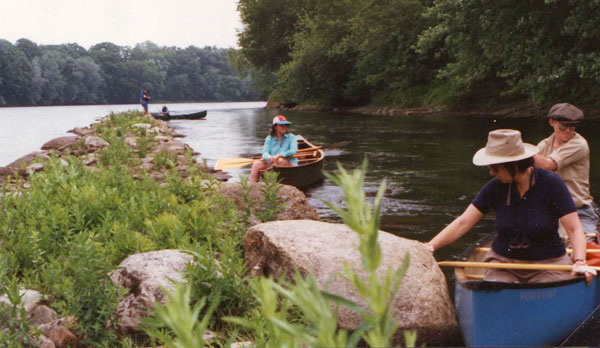
Saturday, April 25 - Joint AMC/MCA Spring Middlesex Canal Walk in Medford and
Winchester. Meet at 1:30pm at Sandy Beach lot at Upper Mystic Lake on Mystic
Valley Pkwy. Info: Robert Winters (617-661-9230) or Roger Hagopian
(781-861-7868).
Directions: Meet at the Sandy Beach parking lot off the Mystic Valley Parkway by
the Upper Mystic Lakes in Winchester. The walk will follow the route of the
Middlesex Canal through parts of Medford and Winchester. Sites along the way
include the aqueduct and mooring basin, those segments of the canal bed and berm
visible off the parkway, and the stone wall of the Brooks estate, in Medford.
Friday-Sunday, April 24-26 - Canal Society of New York, Spring Field Trip, the Chenango Canal: Hamilton to Oxford (tentative site area) Headquartered in Norwich, NY. See <www.canalsnys.org> for details.
Sunday, May 3 - Spring MCA Meeting. Middlesex Canal Museum, at the Faulkner Mill, 71 Faulkner Street in North Billerica. Topic to be announced. See <www.middlesexcanal.org> for details.
Locks and Canals of the Merrimack River
By Bill Gerber ©, e-mail: <wegerber AT gmail DOT com>
Introduction
In the Fall, 2007 issue of Towpath Topics, I presented a chronology of events
that, by 1815 had transformed the initial Pawtucket and Middlesex Canals into a
more than 120 mile network of canals and river navigations. This network had
been brought into existence by, literally, a dozen private, independently
financed companies. In 1816, before beginning construction of the Erie Canal,
and possibly several times thereafter, representatives of New York State visited
to examine New England’s accomplishments.
Consisting principally of canals and community Landings (more than two dozen publicly accessible points where goods could be shipped and received), the network served all of the communities along the Merrimack River, from Concord NH to tidewater above Newburyport; the communities along the Middlesex Canal, as well as the Concord River as far inland as Concord MA; ship builders along the Mystic River, Boston’s Haymarket and its harbor; and East Cambridge and Cambridgeport.
This paper provides more detailed information about the canals that were constructed to bypass falls and rapids along the Merrimack River.
The River
From Concord NH to Chelmsford MA, the Merrimack River drops a vertical distance
of about 135 feet in a succession of 14 waterfalls and difficult rapids. At and
below Chelmsford, the river fell another 92 feet over Pawtucket Falls and six
more significant rapids.1
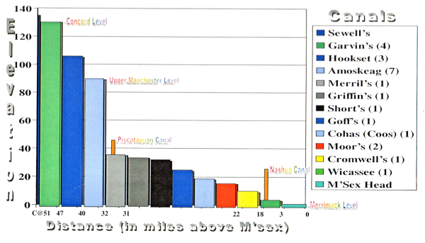
Figure 1, below, provides an elevation profile of the many falls along the
Merrimack River, between Concord NH and Chelmsford MA, also for two of its
tributaries.
Traveling up the river from the head of the Middlesex Canal (from right to left
on the figure):2
|
Figure 1. Elevation Profile, Upper Merrimack River & Tributary Falls |
The first obstruction encountered was Wicasee Falls, by Tyng’s Island in Tyngsborough, three miles above the head of the Middlesex, where the river fell 3 feet in about a third of a mile.
Two lesser rapids, Taylor’s and Hill’s, were encountered above Nashua NH. The drop across these is not known.
Fifteen miles further up was Cromwell’s Falls, with a 6 foot drop in a little less than three-quarters of a mile.
In the nine miles upstream of the town of Merrimack, itself four miles above
Cromwell’s Falls, there were a total of six falls, as follows:
Moor’s, with a fall of 6 feet in a distance of about 650 feet;
Co’os (aka Cohas), 3 feet in 500 feet;
Goff’s, 6 feet in about 1100 feet;
Short’s, 7 feet in about 30 feet;
Griffin’s (drop not stated but probably about 3 feet); and
Merrill’s Falls, 3 feet in about 160 feet.
Amoskeag Falls at Derryfield (now Manchester) was half a mile above Merrill’s Falls. Here, in a series of three falls, the river fell 45 feet in half a mile.
The river was then clear upstream for about 8 miles to Hookset Falls, where there was a drop of 16 feet in about 800 feet.
Seven miles beyond was Garvin’s Falls, with a drop of 25 feet; and one mile beyond Garvin’s there was a further 5 foot drop at Turkey Falls.
The river was then clear to Concord, three miles upstream from Turkey Falls.
Over the period from 1792 to 1815, except for Taylor’s, Hill’s and Turkey Falls, canals and locks were built at all of these sites. Although, in later years, there are reports of boats reaching much further up the Pemigewassett River, to the confluence with the Baker River, historical records suggest that efforts to canalize falls north of Concord, and to extend the system west into Lake Champlain and east into Lake Winnipisauki, were apparently either “stillborn” or failed, or were a “front” for a plot by mill owners to buy up riparian rights all the way to Winnipisauki.
The Canals of the Merrimack
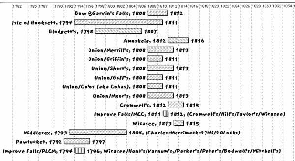
Figure 2, below, presents a timeline of the construction phase of the Merrimack
River Canals, also the Middlesex Canal; i.e., this is the period from the time
when each of the canals was authorized, until it was first opened to traffic.
|
Chart Compiled by the Author Figure 2. Chronology: Middlesex and Merrimack River Canal Construction |
Specifically, what was built along the Merrimack, when and by whom? Let’s take these, geographically, from the top.
Sewall’s Falls Canal - In the mid-1830s, there was an attempt to construct a canal at Sewall’s Falls, the first significant falls north of East Concord NH. This would have been a dual use canal, to provide water power to textile mills that were to be built there and to enable boats, etc., to bypass the falls. About $80,000 was spent on the project, but all indications are that it was abandoned before it was completed.3
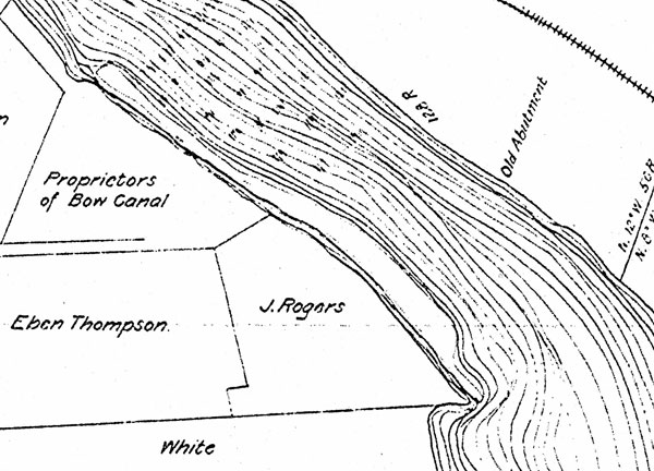
Bow Canal at Garvin’s Falls - In 1808, Israel Aldrich, George Colson, John Carter, Jonathan Eastman, Richard Ayer, James White, Benjamin Noyes and John Eastman were incorporated as the Proprietors of the Bow Canal.4 The canal they financed and constructed was completed by 1812 at a cost of about $21,000.5
|
Courtesy of Public Service Company of New Hampshire Figure 3. Plot-plan of Bow Canal |
Figure 3 is a plot-plan of the site showing the layout of the original canal. It consisted of a 1900 foot long channel, cut into the west bank. A guillotine type guard-gate was built at the upstream entrance to the channel, and a staircase with three 10’ x 90’ lift locks at the downstream end (these were located about where the turbine pit is in the existing Hydro plant), also a 450’ dam was constructed across the river at the head of the falls.
|
Photo by the Author Figure 4. Remains, Bow Canal Guard Gate |
Figure 4 shows the remains of the guard-gate, at the upper end of the Bow Canal channel, minus the overhead structure that once held this ‘guillotine gate’ open above the entrance to the channel. The configuration of the lock gates is not known, but either single swing-gates or miter gates were likely used throughout.
Though the natural drop here was about 25 feet, the dam was built high enough to raise the water level another 4 or 5 feet to flood Turkey Falls, a mile further up the river.
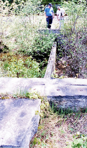
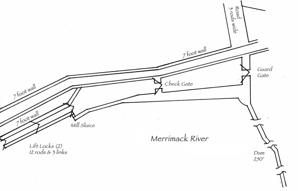
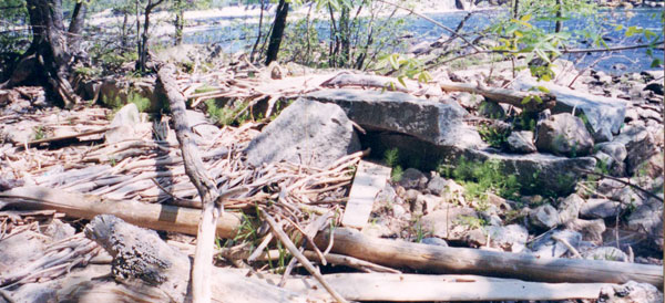
Isle of Hookset Canal - In February 1794, Robert McGregor and William Duncan were incorporated as The Proprietors of the Isle of Hookset Canal.6 Initially, they made little or no progress. The time for completion was extended several times by the New Hampshire legislature. Beginning in about 1810, the Middlesex Canal Company began to invest in this endeavor and, thereafter, provided such extensive support that, by the time this canal opened, they effectively held controlling interest. This effort was completed in 1811 at a cost of $15,000.7
Construction was difficult; the lower lock had to be dug below river level, where the bottom was rocky. The berm-side of the guard lock required strong support, and stone for the locks had to be cut and boated to the site.8
The configuration of the Isle of Hookset Canal is shown in Figure 5. (North and upstream are to the right.) The canal consisted of a 1300 foot long channel defined by a timber-crib berm wall extending from an island at the head of the falls, south, roughly parallel to the west bank. The channel incorporated a guard gate and a check gate at the upstream end, a sluice for a mill, and and a two lock staircase, with 10’ x 82’ lift locks, at the base of the falls. A 250’ dam was constructed from the island to the eastern shore.
|
Drawing by the Author Figure 5. Isle of Hookset Canal, Plot Plan |
Figure 6 shows the debris filled and silted-in remains of the lower lock of the two-lock staircase. No significant trace of the rest of the canal has been found.
|
Photo by the Author Figure 6. Silted-in Remains of the Lower Lock |
Blodget’s and Amoskeig Canals at Amoskeag Falls - These were successive endeavors; Amoskeig (sic) Canal replacing Blodget’s after about 1816.9
Historical records suggest that Judge Samuel Blodget began constructing a canal at Amoskeag Falls in about May, 1794. His work proceeded in phases; the sole purpose of his initial effort may have been to safely transport timber down the falls. Construction proceeded well; but required a significant modification when Blodget’s concept for an autonomously functioning, gated-sluice (or timber slide) proved unworkable. The gated-sluice was then replaced by a pair of locks.
An attempt was made to open the entire canal in 1798. Apparently it met with disaster. Upon letting water into the lock, the wooden sides were lifted by the upward pressure of the water and “the work of the season was the wreck of the moment ... thus the labor of five years [at a cost of $20,000] was brought to naught.” 10
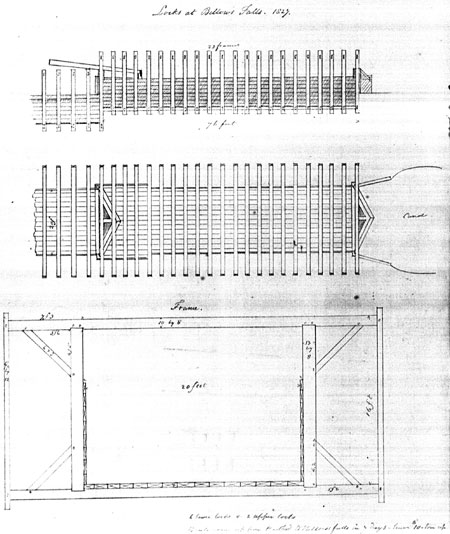
In December, 1798, following authorization by the New Hampshire legislature,11 Blodget called upon Col. Loammi Baldwin to survey a route for the canal and to estimate the cost of completing the work. Baldwin delivered a favorable report, estimating $9000 to build replacement locks, but he also recommended a new route for the canal to be located to the east of the old one.
|
Courtesy of the Manchester (NH) Historical Association Figure 7. Painting Excerpt - Configuration of a Blodget Lock |
By this time, however, Blodget’s finances were almost depleted and the effort to rebuild the canal ran into extensive financial difficulties. At one point, Blodget and Baldwin had a serious falling out over the matter of expenditures; at another, all work was suspended. The legislatures of both New Hampshire and Massachusetts authorized lotteries to raise money to continue the work. It appears that work resumed in about 1802, but may have proceeded in segments as money became available.12 The canal finally opened in 1807 and Bodget was able to ride through in triumph. This was just in time, he died later that year.
The 1807 canal apparently employed 9 locks,13 each reported to be 11’x100’. Little evidence has been found to indicate either the specific location of the channel or the configuration of the locks. Descriptions suggest that the channel extended for more than a mile within and below the falls.
As evidenced by a painting of his home, with the canal passing nearby (excerpt shown in Figure 7, above), Blodget’s initial locks were of all-timber construction.14 In one of his notebooks, George Rumford Baldwin included a drawing of a mitre gated lock, of similar construction, built at Bellows Falls, Vermont.15 His drawing is shown in Figure 8. The painting suggests a construction difference between the two, i.e., the major structural members of Blodget’s lock are fewer but much more robust. (Note also, curiously, that the upper mitre gate balance beams are connected at nearly right angles to the gates.)
|
Courtesy, The Winterthur Library: Joseph Downs Collection of Manuscripts and Printed Ephemera, Col. 204 Figure 8. Timber Lock at Bellows Falls Canal, Vermont; Drawing by George Rumford Baldwin |
In another painting of Blodget’s home, similar scene, what appears to be a ship’s-wheel is shown at the lower, far corner of the lock. Although this might have been used in any of several ways, the wheel suggests that drop gates may have been used at the upper end of Blodget’s locks, with the wheel providing control of the drop gate from the downstream end of the lock.
The locks first built on the Pawtucket Canal were probably of similar timber construction. Also, this was likely the configuration of a lock that failed on the Pawtucket Canal in October, 1796, an event noted in Loammi Baldwin’s diary (which some historians have erroneously interpreted as recording the failure of a lock on the Middlesex Canal).
Beginning in 1812, Blodget’s heirs and other investors began work on a replacement to Blodget’s 1807 canal. Named Amoskeig, this replacement canal opened in 1816. It consisted of a mile-and-a-half channel cut into the eastern bank of the river, with six lift locks and a guard lock.
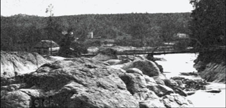
A old stereopticon slide provides a view of the Merrimack River taken from above Amoskeag Falls. An excerpt of this slide, presented in Figure 9, shows: several people fishing; a bridge across one of the rivers channel; and, to the left, partly in the background, a building that is believed to be the entrance to the 1816 canal. In addition, there is the merest sliver of a line, to the right of the building (and the fisherman in the foreground), that probably is a trace of the canal.
|
Courtesy of Steve Garczinski Figure 9. Probable entrance to Amoskeag Canal (by the building at the left) |
|
Figure 10. Plot plan of the Amoskeag Canal, 1835 |
Figure 10 is a plot-plan of the canal and locks as they existed in 1835.16 Four of the locks formed a staircase just off the river at the downstream (right) end of the channel, roughly under the Amoskeag Bridge. Above this there was an intermediate level channel, about 3/4 mile in length, then a two lock staircase that reached the upper river level. Finally, there was a guard lock at the upstream end of the channel.
|
Photo by the Author Figure 11. Partial Remains of the Amoskeag Canal Guard Lock |
Figure 11 shows some of the relatively well preserved stonework of the guard lock and the top-level channel, the only parts of this canal that have not yet been filled in.
At low water, the remains of earlier, canal associated dams, upstream of the current hydro-electric dam, can be seen from the Amoskeag Street Bridge over the Merrimack River.
Union Locks and Canal Company (UCC) - In December 1808, Jonathan and Ebenezer Eastman, Isaac Chandler, and Winthrop Fifield were incorporated by the New Hampshire Legislature as The Proprietors of the Union Locks and Canal. They were empowered to clear the Merrimack River from Reed’s Ferry to Amoskeag Falls, a distance of about 9 miles, and to construct the necessary locks and dams.17
The Union Canal Company encountered serious technical and financial difficulties. In addition to stock shares, lotteries were authorized by both the Massachusetts and New Hampshire Legislatures to raise money to fund construction. Also, the Middlesex Canal Company invested heavily in this endeavor. By 1811 they had acquired 73 of 83 shares of stock and thus effectively controlled the company.18
The six canals with seven locks, described below, were constructed to a similar plan, varying as required by the geography of the local site. The dams and canals of the Union Canal Company were built to withstand submergence. The parts exposed to damage were well protected.19 Lock walls were constructed of large split stones held together vertically by iron pins and horizontally by iron straps set into the stone. In the winter, heavy planks were set into slots to prevent anything from passing through the locks, and the gates were fixed open, chained and locked.20,21
During freshets, floating objects passed over the dams and canal parts. Lumber men took advantage of freshets, bringing rafts of logs down at these times and passing over the canals to avoid paying lockage fees.
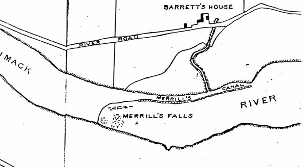
Merrill’s Falls Canal - At Merrill’s, a towpath canal about 1600 feet long was constructed on the east side of the river. The channel included a single 10’ x 82’ lock at the bottom of the falls and a dam about 2500 feet in length that slanted across the river to the western bank. A drop-gate was used at the upper end of the lock and a single swing gate at the lower (this configuration was common to all of the Union Canal Company’s locks). This work was completed by 1813 at a cost of about $10,000.
|
Figure 12. Plot Plan of Merrill’s Falls Canal |
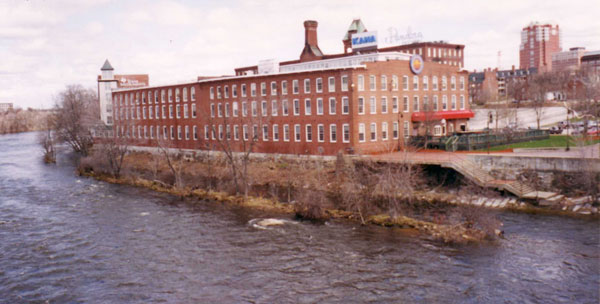
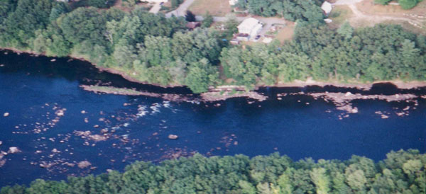
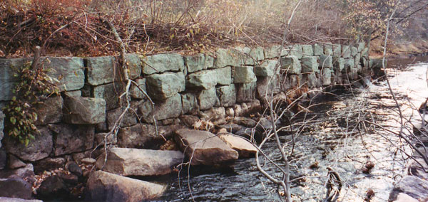
The original configuration of this canal is shown in the Figure 12 plot-plan.22 The upstream entrance was located a short distance, perhaps a half-mile, downstream of the Amoskeag Canal. The remains, still visible looking north-east from the Granite Street Bridge in Manchester, are shown in Figure 13. Note the berm-side of the canal running parallel to the east bank of the river, adjacent to the mills built there in later years. Evidence of the lock has not been found, but it may have been located roughly under the Granite Street Bridge, or possibly a short distance downstream thereof.
|
Photo by the Author Figure 13. Remains of Merrill’s Falls Canal |
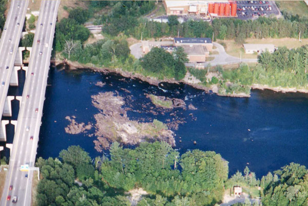
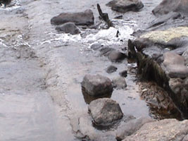
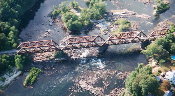
Griffin’s Falls Canal - A towpath canal, about a half-mile in length, was constructed on the east side of the river. A single 10’ x 82’ drop-gate/single swing gate lock was placed about midway in the channel, suggesting that it was necessary to dig the lower channel below the normal river level. A 2500 foot dam was constructed that reached across the river to the west bank. This work was completed by the end of 1811 at a cost of about $4,000.23
An aerial view of the remains of this canal is shown in Figure 14; and the bank-side of the lock is shown in Figure 15.
|
Photo by the Author Figure 14. Aerial View, Remains of Griffin’s Falls Canal |
|
Photo by the Author Figure 15. Bank Side of Griffin’s Falls Lock |
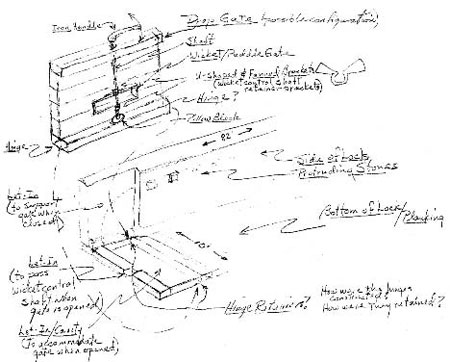
When entering any of the Union Canal Company’s locks, when they were still in use, a boat or raft would have floated into a wooden box without a top. The sides and bottom of the lock were planked, the side planks nailed, vertically, to a heavy beam below the waterline and a second beam at the level of the protruding stones in the lock side, visible in Figure 15. Each of these stones was drilled such that the beam could be fastened to them using “dogs”, i.e., U-shaped (or “staple-shaped”) wrought iron bars with pointed ends, one end anchored in the stone and the other in the longitudinal wooden beam.24
Drop-gate locks were used at the upstream end of all seven lock chambers built by the Union Canal Company, possibly also for the lock chambers at Cromwell’s and Wicasee. (This may have been the first use of this type of lock in the US.) Although this type of gate is usually used in moderate to high lift locks, this is not the case with the Union Company’s canals where the lift was fairly modest.
|
Figure 16. Author’s Concept of the Union Canal’s Drop-Gates |
The drop gate is hinged at either side of the bottom of the lock such that it opens by rotating downward (upstream relative to the flow of the river) into a recess in the floor of the lock. The advantage over swing or miter gates is that, through a linkage (e.g., a chain), a single lock tender could control them from the opposite end of the lock, also they are generally faster to operate. When closed, the gate is held up by water pressure; but the gate, weighted to be negatively buoyant, would fall easily when the lock chamber was full and the mechanical constraints were removed.
Several years ago, a local family cleaned a century of debris out of this lock and (as of summer 2004) the lock still exhibited: an intact planked bottom, the timber-framed recess into which the drop-gate would have fit when lowered and a fragment of the single swing gate (i.e., not a miter gate) at the downstream-end.
Metal parts recovered at this site consisted of a 27” lever arm, several oddly flanged ferrules, and a pillow-block.25 From an examination of these, I generated a concept of the possible configuration of the upper end of the lock and the drop gate. This “author’s concept” is shown in Figure 16, above.
Short’s Falls Canal - consisted of the construction of a single 10’ x 82’ drop-gate lock on the east side of the river, and a dam of about 2500 feet in length that reached to the west bank. This work was completed in about 1813 at a cost on the order of $4,000.26 The still visible remains of this canal are shown in Figure 17.
|
Photo by the Author Figure 17. Aerial View, Remains of Short’s Falls Canal |
The lock remains are adjacent to Manchester’s waste water treatment plant, a short distance downstream from the Interstate 293 bridge. The lock is positioned close to but slightly out from the east bank of the river, opposite the road junction on the land side. Almost the least a canal could be, no evidence of any additional channel berms have been found beyond either end of the lock itself.
|
Video Frames, Courtesy of Roger Hagopian Figure 18. Remains of Drop Gate at Short’s Falls - Two Views (L) Looking west showing sill & upper edge of the gate, and (R) along the shore showing upper-right (NW) corner of same |
Some years ago, a portion of this lock was destroyed when a sewer line was laid across the river to the wastewater plant in the background. A site visit indicates that the upstream stone work portion of the lock was demolished, “severing it” from its upper gate (i.e., the drop gate). The lock sill, the timber-framed gate recess, and the gate itself, all appear to be intact. The fate of the gate hinge assembly is not known. Figure 18, above, provides two views of portions of the sill and gate that are above water during low water conditions.
Goff’s Falls Canal - Another Union Canal Company endeavor, this short towpath canal was built about midway between the center of the river and its west bank. A single 10’ x 82’ drop-gate lock was constructed in the river at the base of the falls. (In this one case, the lower gate may have been a mitre-gate.) At the upstream end of the lock, timber-crib berms connected each side of the lock to a bank of the river; i.e., one berm connected to the west bank, the other to an island upstream, from which a somewhat serpentine dam extended to the east side of the river. The historic record indicates that the dam was 2500 feet in length; but more likely, this was the total length of the berm and dam. This work was completed in 1811 at a cost of about $7,000.27
|
Photo by the Author Figure 19. Aerial View, Remains of Goff’s Falls Canal |
The still visible remains of this canal are shown in Figure 19. The lock is immediately downstream of the west pier of the railroad bridge and, like most of the other UCC locks, is covered with vegetation (two lines).
Under low water conditions, the base of berm cribbing can be seen, under water, upstream of the west abutment of the RR bridge, and upstream of its western pier. The dam probably extended from the larger island, across the smaller island, to the east bank (right side). Bolt holes can be found in ledge near the eastern bank where the dam once ended.
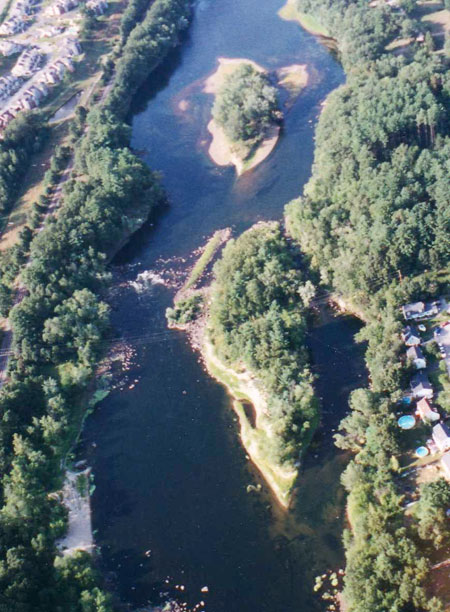
Co’os (aka Cohas) Falls Canal - A single 10’ x 82’ drop-gate/single gate lock with a holding basin above it, and a berm and dam of about 2500 feet in length, were constructed here in a short towpath canal. The lock was built on the west side of an island located on the east side of the river, which placed the lock about mid-river. This work was completed by 1811 at a cost of about $5,000.28 The still visible remains of this canal are shown in Figure 20.
|
Photo by the Author Figure 20. Aerial View, Remains of Co’os Falls Canal |
Not visible in the aerial view, but apparent during a site visit, the upper end of the lock was connected to the island, and the island to the eastern bank, by timber-crib dams capped with large stones strapped together, the first being the source of most of the stones strewn between the lock and the island. The dams also served as bridges/walkways between this site and a lock-tender’s house and stable located higher up on the eastern bank.
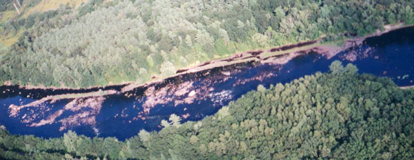
Moor’s Falls Canal - Two 10’ x 82’ drop-gate locks were constructed in a bank-side towpath canal, about 2000’ in length, extending the length of Moor’s Falls. One lock was positioned at the downstream end of the channel and the other placed about midway. Together they overcame a drop of about 6 feet in 40 rods.
The historical records indicate that a dam, about 3200 feet in length, was constructed across the river at the top of the falls. However, it is more probable that this dimension includes the length of both the canal berm and the dam. The work was completed by 1813 at a cost of about $15,000.29 Still visible along the eastern bank of the Merrimack, the remains of this canal are shown in Figure 21.
|
Photo by the Author Figure 21. Aerial View, Remains of Moor’s Falls Canal |
In the photo, the lower lock, at the right end of the channel and fully aligned with it, is completely silted in and covered with growth. The upper lock chamber, now almost obliterated beyond recognition, is in the channel approximately opposite the white object in the river.
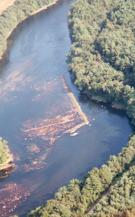
Cromwell’s Falls Canal - Initiated by J. L. Sullivan and associates, the Proprietors of the Locks at Cromwell Falls was incorporated by the New Hampshire Legislature on December 17, 1812. The company was authorized to build a canal and lock at this site.30
A single lock, similar to the one at Wicasee, was built on the westerly side of the river, along with a 2000-foot berm that extended to the head of the rapid. This connected to a somewhat serpentine wing dam that extended toward the eastern bank. The effort was completed by 1815 at a cost of about $9000.
The legislature also authorized the transfer of the rights and privileges of this company to the Union Locks and Canal Company, as an addition to their charter. This was accomplished in August of the following year.
|
Photo by the Author Figure 22. Aerial View:Remains of Cromwell’s Falls Canal |
In Figure 22, the river flows from bottom to top; the lock is in the shadows, under the trees, against the right (west) bank, beginning opposite the far end of the channel berm; and a short timber crib dam (once part of the far end of the berm), connected the lock with the channel berm.
The remains of yet another long linear structure can be seen in Figure 22 intersecting roughly orthogonally to the canal berm, about two-thirds of the way toward the upstream end. This scar is believed to be from a wing dam constructed there as part of improvements made to this rapid in 1811, which probably remained in use only until the canal opened in 1815.
The canal site is located at the southeast corner of the Anheuser-Busch Brewery’s property in Merrimack, NH. An aerial photo of the canal site, and on-site photos of the berm and the lock are shown in Figures 22, 23 and 24, respectively.
|
Photo by the Author Figure 23. Berm of the Inlet Channel, Cromwell’s Falls Canal |
The canal berm (shown in Figures 22 & 23) was still intact and seemingly solid in the summer of 2001. Since then, however, under moderately high water, the berm appears to have been breached in several places.
|
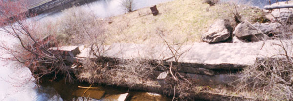
Photo by the Author Figure 24. The Lock Remains at Cromwell’s Falls Canal |
Figure 24 shows Cromwell’s Falls Lock from the downstream side. Note that, just inside the lock, on the left, the skeletal remains of a lower gate are visible. Enough of the gate remains to verify that a single swing gate, 10’ wide, was used at the downstream end.
Taylor’s Falls and Hill’s Crossing - There is no record of canals or locks being built at either of these two sites; however, in 1811, unspecified improvements were made to each site by the MCC; also, in the same year, at Wicasee and Cromwell’s Falls to improve navigation through or around them.31
The term “Improvements” is never explained but likely included the clearing of obstacles along a line to create a clear channel, the construction of one or more wing dams to divert a portion of the river’s flow into the channel to insure a reliable flume, and possibly the installation of an anchor point for a warp-line (to assist boats to ascend the rapids; the remains of a suitable timber crib “anchor box” was found at the Hills Falls site).32 The total expense for all of these improvements, in 1811, was $158.78.
Subsequent to the construction of Wicasee Canal and Dam, completed in 1815, these two sites may have been flooded by the lake formed behind Wicasee Falls Dam; both certainly have been since 1825, by the lake formed behind the dam at Pawtucket Falls.
Wicasee Falls Canal - In February 1813, following authorization by the Massachusetts Legislature,33 the Proprietors of the Middlesex Canal began work on the Wicasee Canal. This consisted of building a 600 foot stone and timber dam across the rapid, from Wicasee Island west to the opposite shore of the river, and a lock, probably 10’ x 100’, between the island and the east shore. The probable lock site is shown in Figure 25.
|
Photo by the Author Figure 25. Probable Lock Site, Wicasee Canal |
One account places the lock about 1900 feet in from the [upstream] end of the island. Another states “the remains of the old lock can be clearly seen where the canal leaves the river, just north of the [Vesper Country/Canoe Club] boat house.” According to Sullivan, “The labor was performed by about 100 men between the middle of July and November. The whole expense, including quantities of powder, much iron, boats, utensils, barracks, bedding and the dam, was $14,000.” 34 It appears that the lock was operable by 1815; a lock-tender’s house was added by 1817.
Satellite photography of the area from the island to the west shore, faintly (too faint to reproduce here) but remarkably shows possible traces of three dams, all still below the level of the river.35
|
Photo by the Author Figure 26. Island-side end of two timbercrib dams at Wicasee Falls Canal |
Figure 26, taken during exceptionally low water conditions, provides an on-site view of the island-side ends of two of the dams. These may correspond to improvements made there by the Proprietors of Locks and Canals on Merrimack River in 1794 (as part of their efforts to make the Merrimack navigable from the New Hampshire line to tidewater); but more likely they relate to improvements made by the Middlesex Canal Company in 1811, and a final dam constructed by the MCC as part of the canal, which opened in 1815.
Sullivan described the Wicasee construction as follows:
“A rapid for half a mile between an island and the western shore is crossed with a dam of stone and timber, 200 yards. This raises the water above [the dam] about a foot, which saved digging on the other side of the island where the lock is placed. This side afforded a passage for high water, six rods wide. From the lock to its entrance is 1900 feet. This space was encumbered with masses of rock of every size and with earth, estimated at 4000 square yards. The lock is placed in the middle of the stream; its side walls are 100 feet in length, connected with the shore by wing-walls, each about 50 feet. The wing-walls are faced with plank driven into the bottom and extending into the shores. The walls, having no support, were necessarily thick to sustain the pressure of the lock and the shock of the freshets. They are 12 feet high and average 8 feet thick, containing 1200 perches.36 The stone was split out large and drawn half a mile, loaded for the most part onto a boat with a crane and windlass, and thence laid. The foundation was difficult, the bottom was encumbered with stones, the water from 2 to 7 feet deep and not being clear, the work of deepening, filling up, and laying the walls under water was done by feeling, diving, etc.”
The lock and dam at Wicasee may have been short-lived. The Pawtucket Canal was rebuilt in 1824, much enlarged to supply water power for textile mills. At this time, a large stone dam was constructed across the river at the head of Pawtucket Falls. This raised the water level by an additional 5 feet, so that it flooded the Wickasee structures.37
Some claim that this lock was subsequently abandoned and the dam was breached to allow passage of boats on the 18-mile lake created behind the dam. However, Wicasee Lock was still carried on the ledgers of the Middlesex Canal Company as late as 1838. It may be that it was still used during periods of low water. Further demolition of the dam was undertaken early in the 20th century.38 (I’ve found nothing in historical records to suggest that the lock was also demolished.)
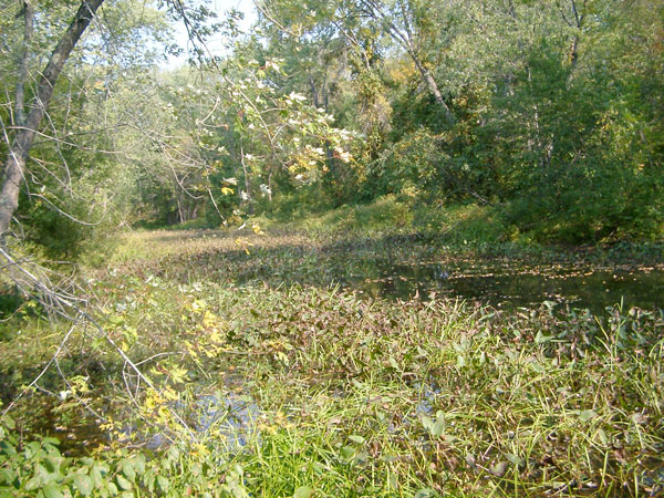
Undocumented Berm - Immediately upstream of the entrance to the Middlesex Canal (about two miles downstream of the Wicasee Canal at Tyngs Island, and just west of the present day Rourke Bridge), there is a half mile berm of unknown origin that parallels the north bank of the Merrimack River. It appears similar to the berm remains at other canal sites further upstream and may have had some role in sheltering boats and rafts from the river current while they waited to cross the river to the head of the Middlesex Canal.
A best guess is that it was constructed by the MCC after the Pawtucket Dam was built, when the basin and probably the bottom lock at the head of the Middlesex Canal were flooded out. As such it would have substituted for the original basin and might have been used to disassemble “bands” of log rafts, so that the individual rafts could be taken across and locked up to that canal’s Concord River level. Figure 27 shows the eastern end of this berm.
|
Photo by the Author Figure 27. Undocumented Berm, Along the North Shore, West of Rourke Bridge |
The Middlesex Canal - The northern terminus of the Middlesex Canal was located about three miles downstream of Wicasee. For cargos destined for Charlestown, Cambridge or Boston, or any of the canal-side towns, three stone locks, set a short distance off the river, lifted boats and rafts about 24 feet to the summit level of the Middlesex Canal.
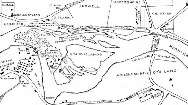
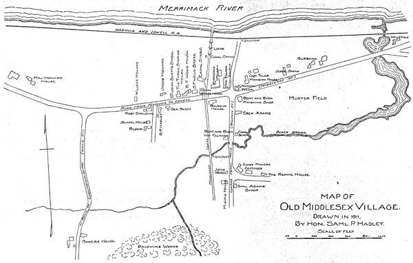
With the completion of Pawtucket Dam, in 1824, the higher river level flooded the basin and bottom lock of the Middlesex, reducing the operable locks to two and the remaining lift to about 16 feet. Figure 28 is a map, drawn by Judge Samuel Hadley in 1911, of Middlesex Village as it existed in his youth, a time when the canal was still operating.39 The two lock configuration of the head of the Middlesex Canal is shown in Hadley’s map.
|
Map by Judge Samuel P. Hadley; Courtesy, Lowell Historical Society Figure 28. Middlesex Village |
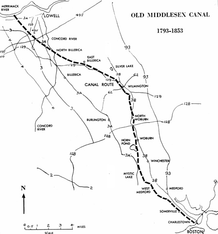
The approximate route of the Middlesex Canal (a full topic of its own, not further discussed here) is shown in Figure 29.
|
|
Pawtucket Canal - With its 30+ foot drop over a succession of rapids, Pawtucket Falls was a major obstruction to the successful delivery of Merrimack Valley farm and forest products to the seacoast north of Boston. From the New Hampshire border to tidewater, this and seven lesser falls impeded transportation to varying degrees.
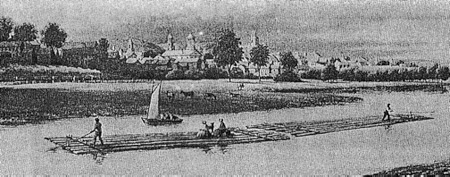
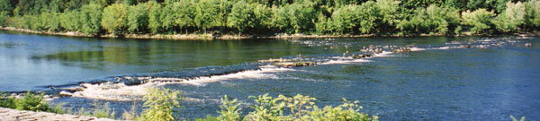
Timber and other products were brought down the Merrimack long before the construction of the canals. Because of the many falls, and their tendency to seriously damage logs that passed through them, there were few free-log drives. The preferred procedure was to bind logs together into rafts, and sometimes to combine multiple rafts together into a band, i.e., multiple rafts connected in train. Figure 30 shows a two-raft band; some bands consisted of as many as ten rafts.
|
Courtesy, Manchester Historical Association Figure 30. Band of Rafts, on the Merrimack River near Manchester |
Under exceptionally high water conditions, rafts could make it through all falls, all the way to Newburyport. But under more normal conditions, rafts would not attempt to run Pawtucket Falls. Instead, the rafts would make it to shore above the falls, near the Spaulding House. Here the rafts would be disassembled into individual logs and a local resident, usualy a farmer, hired to “team” the logs around the falls (generally following Pawtucket Street) to a landing along the lower river near the current site of Lowell’s LeLacheur Base Ball Park. Here, the logs would be reassembled into rafts to continue down river.
In 1792, the Massachusetts Legislature incorporated Newburyport merchants and ship builders as “The Proprietors of Locks and Canals on Merrimack River” (PLC/M). The company was charged with the task of making the river navigable by boats, rafts and masts, from the New Hampshire border to the tidal waters of the river. The PLC/M began construction of the Pawtucket Canal in 1794, generally following the course of Speen’s Brook. The route, including the Speen Brook segment, is shown in Figure 31. This effort encountered significant difficulties, such that the cost rose to double the initial estimate and the scheduled opening had to be delayed several months.
|
Courtesy, Lowell Historical Society Figure 31. Route of the Pawtucket Canal |
A nearly disastrous event occurred at the initial opening, in October, 1796, when a side of the first lock gave way.40 The proprietors referred to this as a disagreeable incident.41 Wilkes Allen, a Chelmsford historian, provided a much more colorful description of the day’s events. He wrote:
“The occasion had called together a great concourse from the vicinity. When a novel and very distressing spectacle was exhibited - some hundreds of men, women and children were collected, and stood around and upon the locks to witness the passing of a boat, in which were the Directors and other Gentlemen invited by them to take a trip through the locks. Scarcely had they entered the first lock when the sides suddenly gave way. The water, bursting upon the spectators with great violence, carried many down the stream. Infants were separated from their mothers, children from their parents, wives from their husbands, young ladies from their gallants, and men, women, timber and broken boards and planks were seen promiscuously floating in the water. Some had their clothes partially torn off, others entirely. Mothers were shrieking for their lost children, husbands swimming in search of their wives and daughters; paleness sat on the countenance and anxiety filled the hearts of those on shore, for the safety of their friends in the water. All, at length, came safely to land without any material injury. Thus ended the amusement of that memorable day.”
This 9000-foot canal around the Pawtucket Falls, in East Chelmsford effectively opened for shipping at the beginning of the season in 1797. Boats and rafts destined for the lower Merrimack and Newburyport proceeded on to the head of the Pawtucket Canal.
Pragmatically constructed, initially, the configuration of the Pawtucket Canal was modified frequently, and to a considerable degree. Table 1 lists the succession of known changes, by year, including the earlier branches added after 1824 to satisfy the textile mills’ increasing need for water power.42
|
|||||||||||||||||||||||||||||||||||||||||||||||||||||||||||||||||||||||||||||||||||||
In 1822-24, in what would become the City of Lowell, the canal’s transportation “thread” was rebuilt to its current configuration as part of changes made to provide water power to the early textile mills. All of the locks were rebuilt of stone, with wood planking, to a length of 115 feet and a width of 25 feet. More than a decade later, in 1841,Warren Locks (aka Concord or Lower Locks) and Swamp Locks were narrowed to 12 feet to save water.
Improvements to the lower Merrimack Rapids43 - During the summer of 1794, Joseph Tyler, who supervised construction of most of the Pawtucket Canal, also oversaw unspecified “improvements” at Wickasick (sic) Falls, where the river dropped three feet in 100 rods. His efforts likely included clearing a channel of rocks and boulders through the falls. Other actions may also have been required to further improve passage, such as blasting of ledge with gunpowder and constructing wing-dams.
In September, 1794, the PLC/M appointed a survey committee to determine what actions were required to render the rapids downstream of Pawtucket Falls navigable, together with the probable expense to the Proprietors and the income that might be obtained if they made the investment. The survey committee consisted of: Loammi Baldwin, Esq., Joseph Tyler, Capt. Nicholas Johnson, Capt. John O’Brien, and Parker Varnum.
Not being one of the identified Proprietors, it is interesting that Loammi Baldwin’s name was first on the list. That he owned 13 shares of stock in the PLC/M 44 might partially explain his participation in the survey; but there is a more likely reason.
Only a month or two earlier, Baldwin had worked with William Weston, a British Canal Engineer, to survey two possible routes for the Middlesex Canal. At that time, Baldwin had an opportunity to use one of Weston’s “Y-Level” instruments which, together with a vertical measuring rod, provided means to make accurate elevation measurements along a survey route. (The “Y-Level” was a precursor to the modern surveyor’s transit.) Baldwin borrowed one of these instruments from Weston, and James Sullivan, President of the Middlesex Canal Company, subsequently placed an order with a firm in London for two more to be used by the Middlesex Canal Company. Quite likely, the PLC/M were anxious to avail themselves of the accurate elevation measurements made possible by this instrument, and Baldwin was the man who both had one and knew how to use it.
The conclusions of the survey committee, as reported to the Proprietors in October, 1794, were: that it was not practicable to construct locks and canals by Peter’s and Mitchell’s Falls (the most significant of the six), and even if it were, the income would fall very short of the return needed for the investment required (not less than 20,000 Pounds). But, they noted, a sum of 1,000 Pounds, prudently spent, would render all of the falls navigable for boats, rafts and masts.
Since no toll could be expected, the Proprietors would not be able to recoup any investment in the lower falls. Nevertheless, they recognized that advantages would accrue to inhabitants living near the river from improvements to river navigation. Because of this, they reasoned, it should not be difficult to collect the necessary funds by contributions from local residents. With approval of the court, they opened a subscription account and proceeded to raise the money. This effort eventually raised in excess of $1400, most of which was spent on the “improvements.”
In 1795, the PLC/M appointed Col. James Varnum, Esq., of Dracut, to supervise improvements to the rapids downstream of Pawtucket Falls - to render these remaining rapids navigable, “agreeably to the Act of Incorporation” - and authorized him to expend the subscription funds to accomplish whatever actions and tasks he determined were required. The minutes of subsequent meetings of the Proprietors suggest that, because 1795 was a “wet year” and no work could be done, the work was most likely accomplished in 1796. (The improvements were probably similar to that which Tyler did at Wickasee, however, no documentation has yet been found that describes the nature of either Tyler’s or Varnum’s work.)
|
Photo by the Author Figure 32. Hunt’s Falls, on the Merrimack River east of Lowell |
Figure 32 is a photo of Hunt’s Falls, one of the two that were not flooded out when the Essex Dam was constructed at Lawrence, Massachusetts, in 1848. (An examination of satellite photography suggests that there may have been a channel against the south bank of the river. [In 1877, after a number of attempts (some of which resulted in grounding) the steamboat Evangeline made it upstream over these falls.)] Of the six falls improved by Col. James Varnum in 1796, Peter’s and Mitchell’s Falls were considered to be the most problematic.
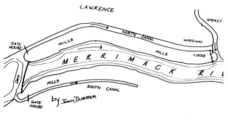
The North Canal at Lawrence, MA - Between 1845 and 1848, the Essex textile manufacturing company, which established Lawrence as a mill town, built the Essex Dam and the North Canal to satisfy their need for water power. Locks were included to satisfy legacy navigation laws.
The dam was built at the site of Bodwell’s Falls, and the lake created behind it flooded out three more of the upstream falls and rapids. As a result, on contemporary maps, only Hunt’s and Mitchell’s Falls can be found; the former just downstream of the Hunt’s Falls Bridge on the east side of Lowell, and the latter on the west side of the oxbow in the Merrimack between Lawrence, Methuen and Haverhill MA.
|
Courtesy, Lawrence Historical Society Figure 33. North Canal (power & transportation), Lawrence MA |
Shown in the sketch map of Figure 33, the North Canal is about a mile in length, running parallel to the Merrimack River. It included a guard lock at the west end, and three lift locks at the east end to overcome a drop of 29 feet. The locks were 20 by 100 feet and employed upper and lower mitered gates. The dam, known as the “Great Stone Dam,” was a marvel of its time and remains so to this day. It was up to 40 feet high and massively built of stone on bedrock; it has never needed repairs.
The locks of the North Canal were filled in, and possibly demolished, in 1966. This action may have been illegal, it is not clear that the navigation laws, that established the requirement for their maintenance, were ever rescinded.
Known Tributary and Industrial Canals
Head Brick Company Canal - There is a placard in front of the Court House
in Hooksett, NH, that tells of this canal. However, little definitive
information has been found to describe it. Supposedly, it was built on the east
side of the river a mile or so above the Isle of Hooksett Canal, and very
sketchy evidence suggests that the canal may have employed a flash lock at the
mouth of a small stream. Whatever was there, was almost certainly used to
transport bricks from the brick yard to the site of early mill construction in
Derryfield, NH; later renamed Manchester.
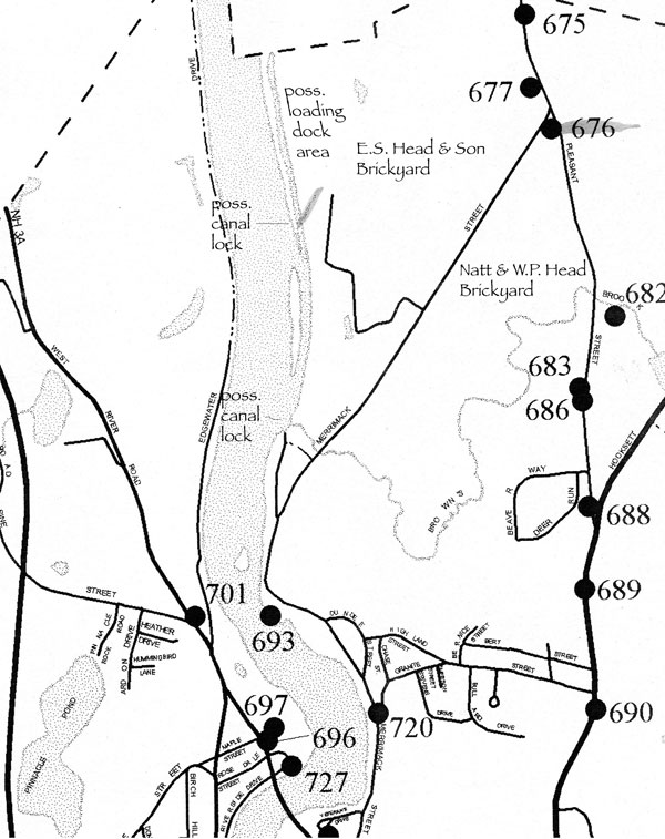
Optionally, a plot plan of the water front, at the site of the E.S. Head brick yard, suggest that there may not have been a canal at all. Instead, there appears to have been a loading dock running parallel to the river, protected by a peninsula, possibly man-made, that formed something of a cove. Figure 34 shows the plot plan of the site with possible lock and loading dock sites annotated.
|
Figure 34. Plot Plan, Head Brick Companies w/ lock and loading site annotations |
Figure 35 shows the now badly overgrown cove site.
|
Photo by the Author Figure 35. Possible Loading Dock Site, Head Brick Company |
Another possibility: it may be that the E.S. Head Company did employ a loading dock; and that the Natt & W.P. Head brickyard canalized the small stream that runs through their yard. If so, then this site may have used a lock.
Piscataquog and Nashua River Canals - canals were built near the junctions of each of these rivers with the Merrimack, to provide access to the respective villages and their merchant and mill facilities within.
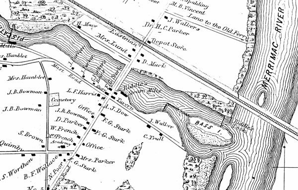
In about 1808,45 Captain Isaac Riddle, a local merchant, built a short canal near the outlet of the Piscataquog River. It was used to enable canal boats to access the center of the village. The canal consisted of at least one lock , possibly two, and two dams, one from the west side of Bass Island, up stream for a short distance, and then to the south shore. The second dam connected the lock, adjacent to the north shore, to the south shore of the island. A plot plan of the site is shown in Figure 36.
|
Source not determined Figure 36. Piscataquog River Canal, circa 1850 |
Two canals were built near the mouth of the Nashua River. The first of these, the upper canal, was used exclusively to power the Nashua Manufacturing Company’s textile machinery. This canal followed a three-mile channel that began at a dam above Mine Falls on the Nashua, about four miles west of the Merrimack. (The present day Mine Falls Park preserves this canal.)
In December 1824, the Nashua Manufacturing Company obtained a charter to build a canal with the necessary locks and dams to connect the Nashua River with the Merrimack. The effort included construction of a second dam on the Nashua River, to create an intermediate river level that still exists, and a canal with 4 locks.
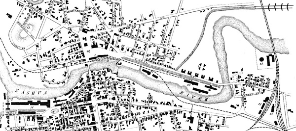
Shown in Figure 37, the Nashua Boat Canal, as it became known, met the Merrimack near the end of Lock Street, a short distance north of the mouth of the Nashua River. Begun in 1825 under the supervision of Loammi Baldwin II, the canal opened in 1826. It’s purpose was to support the village, the several mills along Canal Street, and the Nashua Manufacturing Company.46
|
Source not determined Figure 37. Nashua Boat Canal and Locks, ca 1838 |
The four-lock staircase, each lock being 10 feet wide by 82 feet in length, which overcame a drop of 24 feet, was constructed of stone. The staircase was set in about 300 feet off the Merrimack. The cost of the project was $20,000 for the canal and locks and an additional $10,000 for the dam.
Undoubtedly there were other commercial and industrial canals that have not yet been identified. Regrettably, records of their existence were often lost when the firms that built them ceased operation or moved away.
Suggestions for further reading
Samuel P. Hadley, Boyhood Reminiscences of Middlesex Village (with Map),
Contributions of the Lowell Historical Society, Volume 1, April 1913; pp. 180 to
286
Christopher Robbers, The Middlesex Canal. Cambridge, Mass: Harvard University Press, 1938.
Lewis M. Lawrence, The Middlesex Canal. Boston Mass. 1942. Manuscript reprinted in 1997 by the Middlesex Canal Association.
Mary Stetson Clark, The Old Middlesex Canal. Easton, Pa: Canal History and Technology Press, 1986.
Bert VerPlanck, Middlesex Canal Guide and Maps, Billerica Mass: The Middlesex Canal Association, 1996
Carl and Alan Seaburg, with Thomas Dahill, The Incredible Ditch: A Bicentennial History of the Middlesex Canal. Medford, Mass: Anne Minerva Press, Medford Historical Society, 1997
Many of the records of the Proprietors of the Middlesex Canal, and the Baldwin and Sullivan Families, can be found at the Mogan Center in Lowell, the Massachusetts Historical Society in Boston, the Winterthur Museum Library in Delaware, and the Baker Library at Harvard University in Cambridge, all in Massachusetts.
Exhibits, and some of the same records, can be seen at the Middlesex Canal Museum in North Billerica, Mass.
Links
Middlesex Canal Association <www.middlesexcanal.org>.
Lowell National Historic Park <www.nps.gov/lowe>.
1. Lewis Lawrence, “The Middlesex Canal”, manuscript, Boston, 1942; published by the Middlesex Canal Association, pp.76-78.
2. Lawrence, p.75
3. Walter & Linnea Silver, “Canal Boats on the Merrimack”, New Hampshire Profiles, April 1973, pp.27-28
4. Laws of New Hampshire; “An Act ... Cutting a Canal by Garven’s Falls and Turkey River Falls, ... in the Town of Bow”; Ref. to same, p.654
5. Christopher Roberts, “The Middlesex Canal”, Cambridge, Mass: Harvard University Press, 1938, p.133
6. Laws of New Hampshire, An Act to Incorporate ... Cutting a Canal by Isle of Hooksett Falls; Feb. 18, 1794. Ref to same on p.189
7. Roberts, pp.131-132
8. Lawrence, p.85, (derived from official reports of the Canal Commissioners of the State of New York; Newburg, August 1817)
9. The historical record is both conflicted and difficult to interpret. What follows is the best interpretation I can offer at this time. WEG
10. C. E. Potter, “History of Manchester”; C. E. Potter Publisher, 1856; pp.528-29
11. Laws of New Hampshire, An Act to Incorporate ... Cutting a Canal by Amoskeag Falls; Dec. 24, 1798. Ref to same on p. 247
12. Roberts, pp.130-131
13. Lawrence, pp.80 & 88. Derived from a collection of printed pamphlets and reports of the Middlesex Canal. Massachusetts State Library
14. Excerpt from a painting of the Samuel Blodget House, from a sketch made by Thomas Stickney in 1810, painted by his Grand Daughter. The painting hangs in the Manchester, NH, City Library
15. Baldwin, George Rumford; 1820 to 1830 Notebook, p.75; from the Joseph Downs Collection of Manuscripts and Printed Ephemera, Col. 204, at the Winterthur Library, Winterthur, Delaware
16. R. H. Eddy, “Plan of the Land and Mill Privileges of the Amoskeag Mfg. Co. at Manchester NH”, 1835, plot plan
17. Laws of New Hampshire; An Act to Incorporate the Proprietors of the Union Locks and Canal; Dec. 23, 1808; Ref. to same, p.782; (per L. Lawrence, p.81)
18. Roberts, p.129
19. Lawrence; p.83 (derived from official reports of the Canal Commissioners of the State of New York; Newburg, August 1817)
20. Official Reports of the Canal Commissioners of the State of New York. Newburgh, 1817
21. Sullivan, John L., Letters First Published in the Boston Daily Advertiser; Boston, 1818
22. R. H. Eddy, “Plan of the Land and Mill Privileges of the Amoskeag Mfg. Co. at Manchester NH”, 1835, plot plan
23. Lawrence; p.83 (derived from official reports of the Canal Commissioners of the State of New York; Newburg, August 1817)
24. Examination by the author
25. Author’s interview of the family and examination of the parts
26. Lawrence; p.83 (derived from official reports of the Canal Commissioners of the State of New York; Newburg, August 1817)
27. Lawrence; p.83 (derived from official reports of the Canal Commissioners of the State of New York; Newburg, August 1817)
28. Lawrence; p.83 (derived from official reports of the Canal Commissioners of the State of New York; Newburg, August 1817)
29. Lawrence, Lewis; The Middlesex Canal; 1942, Boston; published by the Middlesex Canal Association; p.77
30. Lawrence; p.81; and Laws of New Hampshire
31. Lawrence, Lewis; The Middlesex Canal; manuscript, 1942, Boston (published by the Middlesex Canal Association) p.59
32. As told to the author by Charles Mower, of Merrimack NH., from his personal observation
33. Statutes of the Commonwealth of Massachusetts. Private and Special, 14 volumes. Boston, 1805-1882
34. Lawrence, pp. 80&81
35. Author’s examination of Google Earth images
36. 1 Perch = 1 rod = 16.5 feet. However, Sullivan’s use implies a volumetric dimension
37. J. W. Meader, “The Merrimack River; its Source and its Tributaries”; Boston, 1869
38. Brendan D. Leahey, “One Hundred Years at Vesper - The Story of Vesper Country Club and Historic Tyngs Island”; photo of the demolition, p.54
39. Hadley, Honorable Samuel P., “Boyhood Reminiscences of Middlesex Village”; Contributions of the Lowell Historical Society, Lowell, MA; Vol. 1, April 1913, pp.184-5
40. Loammi Baldwin noted this failure in his journal; several Middlesex Canal historians have interpreted this failure to have occurred to one of the locks off the Merrimack. The failure, however, was to a lock on the Pawtucket Canal.
41. Minutes of meetings of The Proprietors of Locks and Canals on Merrimack River; ca. November 1796
42. Anne Booth & Harlan E. Unrau, editor; (data compiled from) Historic Structure Report, Pawtucket Canal, Historical Data Section, Lowell National Historical Park, MA; by Denver Service Center, Branch of Historic Preservation, Mid-Atlantic/North Atlantic Team, National Park Service, US Dept. of the Interior, Denver CO; July 10, 1981
43. Minutes of meetings of The Proprietors of Locks and Canals on Merrimack River; 1792-97
44. Baldwin Family Papers, Baker Library, Harvard University
45. Laws of New Hampshire; An Act Incorporating the Proprietors of Piscataquog Canal; June 18, 1806; Reference to same, p.530
46. ...; The Nashua Experience, 1673-1978; Nashua History Committee; Phoenix Publishing, Canaan, NH; p.64
Masthead
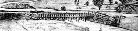
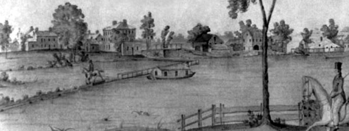
- Excerpt from a watercolor painted by Jabez Ward Barton, ca. 1825, entitled View from William Rogers House. Shown, looking west, is the the packet boat George Washington being towed across the Concord River from the Floating Towpath at North Billerica.Back Page - Excerpt from an August, 1818, drawing of the Steam Towboat Merrimack crossing the original Medford Aqueduct (artist unknown)
Function Room Rental
For the past seven years a group of dedicated volunteers has operated the Middlesex Canal Museum and Visitor Center at the Faulkner Mill in North Billerica. Throughout this time, the generosity of the owner allowed us to stay there rent free. However, he now feels it essential to charge us rent.
We do have good facilities for rental in a charming Museum. Should you plan a function, we hope that you will consider us. A very reasonable charge of $200 covers the room and a committee member who will be present throughout to assist you. For more information phone 978-670-2740; leave a message and someone will return your call.