
Middlesex Canal Association P.O. Box
333 Billerica, Massachusetts 01821
Volume 28, No. 2 March, 1990
COUNT RUMFORD AND ANNUAL MEETING
SATURDAY, APRIL 28, 1990
2-4 P.M.
THE MIDDLESEX CANAL ASSOCIATION invites you to attend an afternoon devoted to the life, accomplishments, and home of Benjamin Thompson, who later became known as Count Rumford. He was a brilliant scientist and inventor, but unfortunately chose to favor British rule and suffered social rejection because of these sentiments. Nonetheless, his name is well known to scientists and engineers today.
We will meet at the Thompson Memorial Library on Elm Street in North Woburn. From Route 128, take exit 35 and head north on Route 38. At the first set of lights, turn left and then almost immediately make a right turn onto Elm Street. This charming library is two-fifths of a mile on your right.
We are fortunate to have as our guest speaker Mr. John Edward Fogelberg, a retired Burlington High School English teacher and town historian.
After the lecture, we will walk to the Count Rumford house for a special guided tour and refreshments.
ANNUAL MEETING: a brief annual meeting will precede the lecture.
This gathering is open to the public. Please bring your family and friends!
SPRING CANAL WALK
Saturday, May 19, 1990 at 1:30 P.M.
(rain date: Sunday, May 20)
Meet at the Wlimington Town Forest. From Route 128, take exit 35 and head north on Route 38 for about 2.5 miles. After passing Brewster's Lumber on the right, turn left into the town parking lot, where we will meet.
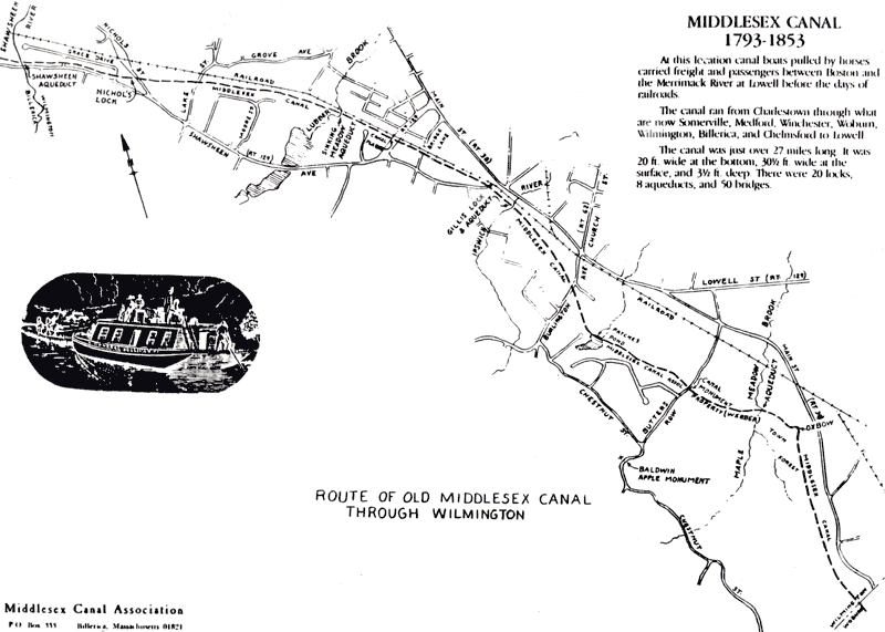
Please put this date on your calendar, and plan to join us for this walk through the Wilmington section of the old Middlesex Canal. A map showing the Canal route through Wilmington is included in this issue of Towpath Topics.
VOLUNTEERS NEEDED: BLACKSTONE CANAL RESTORATION
Preliminary State and National Park funding for Blackstone Canal restoration has aroused public interest for clearing along the Canal. A clearing session is scheduled for 8:30 a.m. to 4:00 p.m. on Saturday, April 21, 1989, beginning at the lock in Millville. Participants should wear hiking clothes and boots, as the banks can be wet, and should bring lunch, and rake and/or brush cutter.
Millville is on Route 122 about 7 miles northwest from Woonsocket, RI. The lock is just south of the center of the town, on the west of the highway. The railroad station and a covered bridge once stood on the site.
With enough volunteers, some clearing might also be done at Goat Hill Lock, a mile north from Hartford Ave. (Route 16) at Uxbridge.
All MCA members and friends are urged to help in this effort, and to see some great masonry construction. We may see a canal running in our time!
MARY STETSON CLARKE HONORED
Mary Stetson Clarke, founding member and long-time Director of the Middlesex Canal Association, was honored recently by the Melrose AARP Chapter in observance of Women's History Month. In recognition of her pioneering and contemporary achievements in historical, literary and library organizations in the City of Melrose, she was presented with the Women's Initiative Award of Excellence. Mary Clarke is, of course, known to canal buffs as the author of the recent book The Old Middlesex Canal. Congratulations to Mary Stetson Clarke from all of us!
PRESIDENT'S MESSAGE
Members and friends:
As I write my last president's message to you, many pleasant and a few sad memories come to mind from these past few years.
Portions of the Canal have been removed or obliterated, as seems the case every passing year. Some old friends are gone from this landscape too, including our longtime members, archivist Joe Kopycinski, treasurer Malcolm Choate, past president Paul Pearsall, and benefactor Frank Dignon.
On the brighter side there are many new faces among us, new members and others more active now than before.
Our informative public programs have been many and varied, including programs about specific canals, both historical presentations and current travelogues, and the wider view as provided by an enthusiastic British canal restoration buff, an historian of American civil engineering, the Park Service in Lowell, and others. Our spring and fall walks have covered more and different routes, and continue to draw good crowds for refreshing outdoor hikes. Last year, in connection with the annual meeting of the American Canal Society, we escorted two busloads of visitors along the length of the Middlesex Canal. We have seen the Middlesex Canal Commission progress with, and almost complete, its project of placing permanent historical markers along the canal route in each town. We have arranged for the reprinting and distribution of Mary Clarke's excellent book on the Canal. Our archival material has found new housing in the Mogan Center in Lowell. Through the hard work of Burt VerPlanck, we are about to publish a set of maps for use in each of the canal route towns.
I look back on these last few years with pleasure, honored by the acquaintance and support of the good men and women who make up this organization. However, other duties call, and I must step aside in order to devote more time to my duties as chair of the historic district study committee in Billerica.
To those of you who have not had the privilege of serving on the board of this association, I invite you to participate in this rewarding and entertaining experience. You will meet and get to know citizens of the first order. The hard work of the officers and directors, and the enthusiasm of our guests, is truly impressive. I am grateful for the opportunity to have been of service to the Middlesex Canal Association and look forward to participating on the board as a director.
With best regards, David Allan Fitch
future former president, MCA.
MCA LOSES TWO MORE FRIENDS
We are very saddened to have to report the passing of two friends of the Middlesex Canal Association - Walter Barczykowski of Lowell, and James Wilson of Staten Island. Our deepest sympathies go out to the families of both.
[Editor's note: The following article is reprinted by permission from the Woburn Times Chronicle of January 19, 1990.]
WALTHAM BANK BIDS $650K FOR BALDWIN MANSION
by William F. Sullivan
WOBURN - The on-again, off-again sale of the Baldwin Mansion, known in more recent years as the Baldwin Landing Restaurant, was on again this week, and it appears that the building has been sold.
The successful, and only bidder, for the 200-year-old structure and the land on which it rests, was the Guaranty First Trust company, the same firm which foreclosed on the property and ordered the public auction.
The bidding was opened by Auctioneer Paul Saperstein shortly after 2 p.m. Jerry Parkhurst of the Waltham bank was the only bidder and Saperstein ordered the auction ended with the property sold for $650,000.
Parkhurst then offered $10,000 for the contents of the building, and Saperstein, when no further bids were received, said - "sold".
One of the stipulations was that the successful bidder pay the city of Woburn about $26,000 in back taxes and about $2,000 in water charges.
The only city officials in attendance during the procedure were Dennis P. Donovan, chairman of the Woburn License Commission, and Leonard Harmon, Vice Chairman of the Woburn Historical Commission.
Both Donovan and Harmon said that they were only there as "observers".
Also there as observers were the original owners of the restaurant, Eleanor and Jack Mooney of Burlington, and Attorney John Veysey.
An inspection of the interior of the building by the Daily Times Chronicle before the bidding revealed that considerable deterioration had set in. Heavy damage had been inflicted in December, when a water pipe in the sprinkler system had ruptured.
Originally situated on Elm Street where the North Woburn Liquor Store now stands, the Baldwin Mansion was relocated to 2 Alfred Street adjacent to the Middlesex Canal, under the direction and guidance of the Historical Commission.
The building was the home of Colonel Loammi Baldwin who is referred to as the father of civil engineering in the United States, and designer [and superintendent of construction] of the Middlesex Canal.
The property, after considerable debate, was sold in the early 1980's to Eleanor Mooney by the city of Woburn for approximately $42,000 with the stipulation that the Historic Commission be allowed to conduct its meetings within the structure.
Harmon said this week, "that agreement was in effect with the excellent cooperation from the Mooneys and from the Waterford Corporation later, until the building was padlocked."
Mrs. Mooney, after spending considerable money to completely renovate the interior in a 1700-era decor and constructing an addition, opened under the name of the Baldwin Landing Restaurant in the spring of 1983.
In 1988, the mortgage was assigned to Kenneth G. Bedrosian of the Waterford Corporation, and it was continued as the Baldwin Landing Restaurant until the Waltham bank foreclosed and padlocked the building last June on Bunker Hill Day.
An auction was conducted on the premises six days later, and the high bid was $710,000 to an unidentified bidder who later turned out to be Martha Bedrosian, wife of Kenneth Bedrosian.
However, the sale apparently never materialized to the satisfaction of the Waltham bank, and a second auction was scheduled for early last September.
From that point on there were several postponements until this week, when the building went on the auction block again.
In the interim, the Woburn License Commission revoked the liquor license at that location.
There were no reports from the Waltham bank of what the future holds for the historic building. It is presumed that the bank made the successful bid in order to gain clear title, indicating that it will be sold privately at a later date.
Whether it will remain a restaurant remains to be determined.
FALL MEETING 1989:
PATRICK MOGAN CULTURAL CENTER
On Saturday, November 4, 1989, the Middlesex Canal Association held its fall meeting at the Patrick Mogan Cultural Center of the University of Lowell Center for Lowell History. Martha Mayo, the Curator of Special Collections talked to us about the MCA collection stored there.
In 1970, the University of Lowell entered an agreement with the MCA to house, catalog, and make available to the public, the collection of historical material in the hands of the MCA. At that time the collection consisted of a few documents, photos and maps. However, in the mid 1970's, as the Middlesex County Courthouse was being moved to its new building in Cambridge, the bankruptcy documents of the Middlesex Canal were found in the basement. These included all receipts, invoices, treasurer's reports, board meeting minutes, etc., from the entire life of the Company. This large collection was turned over to the archives at the Mogan Center, and is now under the care of Ms. Mayo. Following her talk, we were invited to peruse the collection of materials housed there.
In 1974, the University of Lowell entered into a cooperative agreement with the National Park Service to open part of the Mogan Cultural Center as a museum demonstrating the living arrangements for the Lowell "mill girls." After visiting the MCA archives, attendees were encouraged to walk through the building and look at the displays. These included the sitting room and kitchen for the house mother, a typical bedroom occupied by two girls, and display cases showing clothing and personal effects of the era.
THE PAWPAW TUNNEL
by David Dettinger
Canal tunnels were always rare in America, and few remain today. An outstanding example exists on the Chesapeake and Ohio Canal near Cumberland, Maryland. My wife and I had the thrill of walking through it last June, during a week-long tour with the Canal Society of New Jersey.
Accompanied by a park ranger with a powerful flashlight, we entered through an impressive stone portal at the downstream end. Here we could catch a glimpse of the exit portal 1100 feet away, "the light at the end of the tunnel." A towpath ran alongside the water, bounded by railing with a wooden rail at the top that tow ropes had worn smooth. In the blackness there were occasional drips from overhead - few on our heads, fortunately.
At intervals the ranger would stop us to point out the vertical shafts dug down through the hilltop at the time of construction. The brick work was handsome; only a little had required restoration. At the far end we found ourselves in a deep curving rock cut, dug when tunneling proved impossible. Beyond lay the Potomac River Valley, where the canal continued its course alongside the river.
The story of the tunnel proved as interesting as its features. We learned that the contractor was a Methodist pastor, whose faith was greater than his resources! The laborers available lacked the necessary skills, the loose shale was hard to handle, and labor strife was continual due to poor working conditions, sickness and accidents. Everything was done manually, including the blasting with unreliable black powder.
The Pawpaw Tunnel was cut to avoid a six-mile loop in the Potomac River and thereby save digging and mileage. However, it constituted a bottleneck on the canal. Downstream boats had the right of way, but many an argument arose while boats waited at the portals. One pair of boat captains were so stubborn that after several days both had to be driven out by smoke from green cornstalks!
The tunnel took fourteen years to complete, opening to traffic in 1850. It continued in use until 1924 when floods, financial problems, and competition from railroads forced the canal to cease operations.
Our tour of the Pawpaw Tunnel was only one highlight of a rewarding week. The organizers of the bus tour had done a careful job of scouting and planning every detail of the excursion so as to make best use of the available time. As we proceeded westward from the Georgetown terminus, we had ample opportunity to explore the rugged features at Great Falls. Here George Washington had engineered an early bypass on the Virginia side known as the Patowmack Canal. We were able to trace its route and clamber down its steep gorge to the lower river level. On the Maryland side we enjoyed a mule-drawn boat ride, announced by a boatman's horn (which Dave offered to sound to everyone's delight) and passed through one of the 74 locks that dot the canal.
We had generous time at Harpers Ferry, famous for John Brown's raid on the federal arsenal. The U.S. National Park Service has done an inspired restoration of this unique location, which offers many attractions other than the canal itself. Incidentally, the Park Service has located here its Media Center, where displays are prepared and museum objects preserved for all its far-flung parks; we enjoyed a hosted tour of their facilities through the intercession of Lanz Metz, the canal historian from Pennsylvania.
We found Cumberland, Maryland, the westernmost point reached by the canal, a fascinating community with a labyrinth of waterways and railroads, along with an historical setting of the town's glory days. We were even able to board a restored steam train for an hour's ride to Frostberg, watching while our locomotive rotated on a turntable for the return ride.
It is our membership in the Middlesex Canal Association that has opened up for us trips like this with other canal societies, as it has for previous tours of the Erie, Black River, and Rideau Canals.
JANUARY MEETING:
THE CUMBERLAND AND OXFORD CANAL
The Winter Meeting of the Middlesex Canal Association on January 21, 1990, in Winchester, unfortunately coincided with a wind-driven snowstorm, which limited attendance to about a dozen hardy (fool-hardy?) souls. However, their bravery was well rewarded. Ernest Knight, historian from Raymond, Maine, gave a most interesting talk illustrated with slides, describing the remains, as well as the history, of the old Cumberland and Oxford Canal, which ran from Portland to Harrison via Sebago and Long Lakes. His family owned and operated many of the boats and were active in the Canal operations.
We will urge Ernie and his wife Louise to come south again for a return engagement so that more of our Association can enjoy his talk.
"ELEGANT SKATING"
Fran VerPlanck sends this item found in the Boston Public Library while she and Burt were looking for material related to her great grandfather's 1838 journal:
Boston Evening Transcript, Wednesday, November 28, 1838
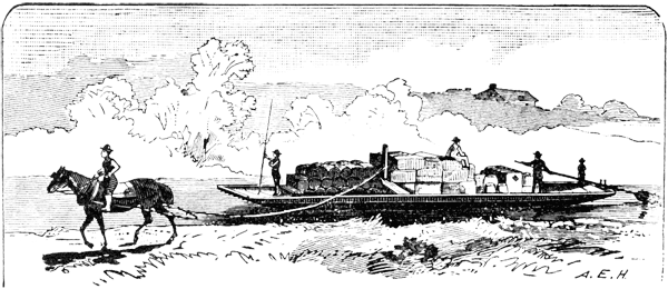
Elegant Skating on the Middlesex Canal - So says a memorandum left on our table this morning by one who loves to course over the ice and disport in rapid whirls on its polished surface, more dearly than the Cape Sparrow delights to travel on the stormy coast of Tierra del Fuego. We doubt not, therefore, that when he is on the canal there is "elegant skating."
Fran adds, "Could not the Cape Sparrow be the arctic tern?"
FALL CANAL WALK 1989
by Frances B. VerPlanck
Approximately 65 people attended the Fall Middlesex Canal Walk through Chelmsford and North Billerica on Saturday, October 14, 1989. Along the way, the walkers went through our newly acquired 1600-ft. easement from the UPS, and also through sections of the watered Canal in Billerica. The majority of the walkers were members of the Appalachian Mountain Club. MCA board members who gave additional explanations to walkers en route were Leader Jean Potter, Dave Fitch, Howard Winkler, Wil Hoxie, Betty Bigwood, and Fran and Burt VerPlanck.
Jane Drury, board member from Chelmsford, provided us with a topographic map of this stretch of the Canal, including colorful and poetic "remembrances" of the past, of which we submit the following:
1942 - "Passing a wooden Culvert, the canal arrived at Manning Bridge, No 45 on the Chelmsford Road leading to Lowell (Riverneck Rd. - J. Drury]. A little beyond is River Meadow Brook, or Hale's Brook, formerly called Mill Brook and Chelmsford River."
1989 - Manning's Bridge was formerly at the location of the new Middlesex Canal Commission Monument. The Manning family lived in East Chelmsford, near here, and owned much of the land around here. They sold some land to the Proprietors for the canal. Canal Road, on the opposite side of Riverneck Road from the Monument, is located on the towpath of the canal. The road has gradually encroached over the canal bed, but the berm and some of the "ditch" remain in many places on the east side of the canal.
1810 Nov. 8 Directors' Meeting report - "Bridge 45 - preparations are made to do the necessary repairing on this Bridge. The wood work must be entirely new - stone made ready for renewing the towpath. This is called Manning's Bridge."
1931 June, from The Old Middlesex Canal by Mal Wood - "In the spring of the year, the meadows roundabout were flooded, only the towpath, the eskers, and the causeway standing out high and dry about the swales. Cat-o'-nine-tails invite bobo-links, red wings, and all the less flashy tribe of migrants and visitants to this birds' paradise. Tanagers and finches frequent the oaks along the dry ridges. Fishermen from time to time venture phlegmatically out into the marsh, following the curving stream in search of finney prey. Kingfishers and hawks eye them insolently, glorifying in flight. The turquoise sky is winrowed with fleecy clouds, as though Asquard were bleaching a fair white crop of pearly hay in the fields of heaven. A mackerel sky at sunset is often reflected in purple and magenta, rose and gold, in the pools of the marsh. It is a spot frequently visited, a feast of beauty to revel in, full of ecstatic moments and long hours of sunlight falling with fruitful benison over the wide earth ...
Toward Brick Kiln Road (Chelmsford) and North Billerica:
"From Hale's Brook (Rivermeadow Brook) to the Riverneck Road is only a few steps, through white pines that have pre-empted the old canal bed and bank, and past a house a few rods away. A dirt road follows the "ditch" across Riverneck Road leading to an isolated farm. Amelanchier, the shadbush, whitens the banks in spring, and anemones spread white carpets of windflowers in the canal bed. Beyond the farm the road becomes a lane, posted as dangerous but passable to light cars, and to all pedestrians not afraid of the dog, who is vociferous and demonstrative, but not dangerous. To the right, partly in a grove of small maples, and partly in the farmyard, is a pocket-sized drumlin about twenty feet high. Grey birch, white pine, and chokeberry crowd the lane along this stretch, and have completely overgrown the canal .... Maples, of course, reign in the swampy regions, with long lines of alders wet rooted in the meadows, but white pine and grey birch have the best of it."
To the north, towards Lowell, and not included on the 1989 Fall Walk are the following 1942 descriptions:
"A little beyond is River Meadow Brook, or Hale's Brook, formerly called Mill Brook and Chelmsford River. The foundations of the aqueduct across this brook were found to be insufficient and unsafe, and the structure was rebuilt in 1810. The work was unusually difficult because the foundations had to be placed in water eight feet deep. In 1810 the aqueduct was about 40 feet long. At that time it needed repairing and the towing path had to be rebuilt. A sketch made in 1830 shows the wooden trunk of the aqueduct supported on two stone piers, and three intermediate supports or posts. The aqueduct was rebuilt in the spring of 1831."
(Rivermeadow Brook and the Aqueduct were approximately at the end of the Manning property, where the "ditch" currently ends in the direction of, but nowhere near as far as Wang Towers.)
"From here, the canal ran in a straight line for about two miles across "Long Swamp" or "Great Swamp." As the "meadows" were about ten feet lower than the canal, a great amount of material was required for the embankments. About forty rods beyond River Meadow Brook, the canal widened to form a basin, called "Sullivan's Harbor."
"In the midst of the swamp, near the 25 mile point, where the canal touched a corner of Lowell, was Long Causeway Bridge, or Bridge No. 46. It was rebuilt in 1825 with stone abutments and stone towing path. The original bridge was all wood. Beyond the 26 mile mark, still in the swamp, the canal curved eastward and then again ran straight, to Middlesex Village."
[Editor's note - a map of the Chelmsford region can be found in the March 1989 issue of Towpath Topics.]
UPDATE ON THE HADLEY HOUSE
The March 1989 issue of Towpath Topics contained an article describing the history of, and attempts to save, the Hadley House in Middlesex Village. Jane Drury found the following in "Boyhood Reminiscences of Middlesex Village by Hon. Samuel P. Hadley, in the Contributions of the Lowell Historical Society, Vol. 1, No. 2, July 1911:
The house in which I live, and in which I was born, October 22, 1831, was built (the main portion) in 1822 by a Mr. Harvey Burnett. Mr. Burnett lived in the main portion until 1827 when my father bought it, and in 1828 added a wing to the south. While Burnett lived in the house, Francis Brinley had a law office in the east room, and his sign was placed on the outside of the house. In 1830 Dr. Hezekiah Packard, pastor of the village church, with his daughter occupied a part of the house and the east room was used by the doctor for a study. The doctor's son, William, a youth of 18 and a member of Bowdoin College, died in this room in 1833.
Jane adds that Mr. Hadley gave several pages of memories about the Canal, including his first trip, made in his mother's care, "when I was a little fellow of about four years old, in the old passage, or as some called it the Packet boat."
In January and February 1990, Al Welcome, author of the previous article, added the following comments on the status of the Hadley House. The city of Lowell is funding the move of the house to State Park land near the Francis Gate (Pawtucket Canal). The Jaycees have control of the actual moving. The funding is all in place.
The house will be split and moved in two portions: the main (front) section and the ell (rear). It was hoped to move the house last October; iron beams were placed under the building in preparation. The relocation was held up by the telephone strike (it is necessary to move many wires); when that was settled, the state announced that the house couldn't be taken over the High Street bridge until a structural safety study was done. An outside engineering outfit was hired to do the two-month study for $6000; this work was completed in February.
The house will be located on Broadway Street near Francis Gate, on State Park land. After all the delays, the house is finally scheduled to be moved in April, subject to the vagaries of the weather.
Al notes that the senior Samuel Hadley was in charge of the Chelmsford (Lowell) end of the Canal from 1822 until its close. His son, Judge Hadley (b. 1831) helped his father as a young man by taking tolls during summer months, when not in school.
SURVEY AND PLAN FOR MIDDLESEX CANAL
(from "INDEPENDENT AND UNIVERSAL" Published at Boston by Adams and Larkin, Vol. xxv - No. 1299, Monday, September [date missing, probably 1793))
REPORT of the Committee appointed by the proprietors of the MIDDLESEX CANAL, on 1st August, 1793, to procure a survey and plan of the ground where the Canal may probably run, from Merrimac to Mystick-river.
THE Committee appointed to procure a survey and plan of the proper ground for making a Canal from Chelmsford to Medford, beg leave to report as follows:
On 7th Aug. 1793, the survey was begun at Medford-bridge by Samuel Thompson, Esq. of Woburn, and the course of the Mystick-river carefully traced by way of the Ware-bridge between Charlestown and Medford, to a large pond lying northerly from the Ware-bridge. The course of the river is serpentine; but as the margin on both sides is marsh, the course is easily straitened; and as the tide rises to the mouth of the pond, sufficiently for loaded boats to pass at high-water, there does not appear to be any difficulty in this part of the course. The distance between the two bridges is about two miles and an half. Two miles more carry us to the head of the pond, which is generally a quarter of a mile wide. The only part of it in which a current is perceptible, is a bar which crosses the middle of the pond. The bottom of coarse gravel at this place is very easily deepened. The head of the pond we estimate at six feet above the half-tide at Medford-bridge. Pursuing a large brook from the head of Medford-pond, to where it crosses the road from Woburn meeting-house to Boston, near the Black-horse tavern, we find the distance to be about a mile and an half; the course of the stream to be very winding; the bottom hard gravel, the banks meadow land, and the valley thro-which the stream runs, to be of sufficient width to allow of straitening the channel so as to avoid any sudden bends. At the road is a mill, known by the name of Abel Richardson's mill. The bottom of his mill-dam we find to be nine feet above the head of Medford pond. A rapid in the stream, near John Symmes's house, will point out a proper place for a lock.
About a quarter of a mile above Richardson's mill, at a place called Blind-bridge, a stream from the westward crosses the road, and joins that which we surveyed. It comes out of Horn-pond, in this vicinity. In hopes of finding a rout this way into Concord-river, at Bedford, the Committee viewed the springs, that supply Horn-pond, as their sources; but we found the meadows, in which they rise, to be surrounded by high hills, being part of a ridge that stretches across from Wilmington, to the north-west parish in Cambridge. We went to the lowest ground on the top of the hills, and found that the height above Richardson's mill, exceeded an hundred feet, and that there was no supply of water for a Canal; this being an insuperable difficulty, we pursued the valley from Richardson's mill, through the east part of Woburn, up to Wilmington, and found a regular ascent, 'till we come to the meadow, which is crossed by Ipswich-river. All this way we find a regular channel, and within half a mile of Ipswich-river is water running towards Medford-pond. Several mills stand on this brook, which is one of the heads of the stream that crossed the road at Richardson's mill. This branch, which we traced, is known near its source, by the name of Shred-pine-brook. But while the mills prove the rise of the land, the moderate height of the dams, being only from three to five feet, proves that rise to be moderate; as the whole fall of water at each is occasioned by the dam, the mills are about a mile apart, and make back water from one to another.
Ipswich-river crosses the road from Andover to Boston, about three quarters of a mile from Dean's tavern in Wilmington, and about twelve or thirteen miles from Boston. At Wilmington it is called Maple-meadow-river. The meadow, through which it runs, is extensive, and as high as the channel that we surveyed from Shred-pine-brook, for a ....
[line missing - torn]
stop the water from running in that channel to Mystick-river, and to confine it to the Ipswich. By this means a dry valley, of about half a mile long, is formed between Maple-meadow and Shred-pine-brook, where there is water only when supplied by rain. Crossing the Maple-meadow about two miles, and keeping near the upland, we come to Jaques's mill, in Wilmington. It stands by the road from Boston to Andover, and on one of the branches of Ipswich-river. We pursued the brook that supplies it, through extensive meadows to Sandy-pond. The rise of land was about ten feet and an half. From thence we passed by a valley of low upland to Beard's mill, on Shawshin-river. The valley rises about two feet above Sandy-pond; but when we come to the bank of the river falls suddenly. The surface of the river is about four feet below Sandy-pond, and the Canal must pass over it on a short aqueduct. From this place to Billerica Bridge, over Concord-river, is about three miles, by way of French mill, upon Content-brook, and round the north side of Foxhill in Billerica. Content-brook falls into Shawshin-river, and the highest part of the valley, in which it runs, is about one third of a mile from Concord-river. The ground is on the height twenty-four feet above the foot of Beard's-mill, and fifteen feet above the water at Billerica Bridge. It is but little way that the ground is of this hight [sic]. Our whole rout from Medford-bridge to that of Billerica is about twenty-three miles, and possibly the elevation of the ground on this side Concord-river, may be equivalent to one mile more. The whole rise from Jaques's-mill by the aide of the same meadow, to Sandy-pond, is ten feet and a half more, which makes the height of Sandy-pond to be sixty-feet. Four feet and a quarter being deducted for the descent to Shawshin-river, and twelve and three quarters added for the rise from the Shawshin to the Concord, makes the whole ascent from Medford-pond to Concord-river at Billerica-bridge, to be sixty-eight feet and a half which is about forty-six inches to a mile.
About half a mile below Billerica-bridge is a ford across the river, where the water is hardly a foot deep at present. A mile below the ford, on the north-west side of Concord-river, we find a small brook. The swamp, from which it rises, has another outlet, by the name of Black-brook, which runs across an extensive meadow, called River-meadow, and lying between the Concord and the Merrimack, in Chelmsford. Black-brook, after joining the River-meadow brook, falls into the Concord-river, about three miles below Billerica-bridge. Upon this Meadow-brook are two mills, called Davis's mills, below the union of this stream with Black-brook, and they reckon the height of water in the upper mill-pond to be thirty feet higher than the foot of the lower dam. This is more than the whole descent of the Canal now making at Pawtucket falls, in Merrimack-river. Therefore the swamp through which our survey runs, is higher than the surface of the water above the falls. When we leave the swamp to cross the River-meadow, it is necessary to steer for the most easterly part of the hill, on which Mr. Marshall, the trader's house stands. From the foot of that hill looking down the valley, a barn is seen, nearly at the distance of a mile, standing on the high ground of the Merrimack-river. The meadow is probably at this place about three feet higher than the waters of Merrimack. Pursuing the valley, and inclining to the eastward of the barn, which belongs to Mr. Bateman, we come to the river at a single oak tree in the road, near an oak stump, about half a mile above the head of the canal now making, and about twenty rods below the principal mouth of Black-brook, which is here called the head of Black-brook; but improperly, for the water runs into the Merrimack, and not, out of it. The bank of the river extends back about a quarter of a mile at the same height, when the valley begins in ....
[torn]
Merrimack at sixteen feet and an half above that of Billerica-bridge, and the distance, according to the general course of the survey in miles. We find no ledges of rocks in the whole distance.
The distance from the bridge in Medford, to Concord-river, on a strait line is about miles, and from Concord-river in Billerica to Merrimack, where a Canal may be formed is about miles.
| Loammi Baldwin Benjamin Hall James Winthrop Ebenezer Hall |
Committee |
Medford, 26th Aug. 1793
CONTRIBUTIONS NEEDED FOR TOWPATH TOPICS
Your editor would be delighted to receive from any of our members contributions for inclusion in Towpath Topics. You can send them to me: Martha L. Hazen, 15 Chilton St., Belmont, MA 02178. If you have any questions or comments about this newsletter, please feel free to call me at 617/484-3634.