
Middlesex Canal Association P.O. Box 333 Billerica, Massachusetts 01821
www.middlesexcanal.org
Middlesex Canal Association P.O.
Box 333 Billerica, Massachusetts 01821
www.middlesexcanal.org
| Volume 46 No. 2 | March 2008 |
PRESIDENTS MESSAGE
by Nolan Jones, President
The activity level of the Association has gone up recently. We are cooperating with a Medford group, TRITEC/Voices Rising, recording historic documents for use in teaching history. We will be donating a set of our publications to the Charlestown Historical Society as soon as weather permits. And we have had contact with a Boston group about historic markers along the canal route.
The Museum opens this March 15 with a docent training meeting at the Museum on March 8 from 10am to 12pm. We are an all-volunteer organization and always need docents to guide weekend visitors. Please contact the museum if you are willing to volunteer (978-670-2740).
Tom Dahill has recently returned from Florence, Italy, getting renewed energy for more exhibits in the Museum.
Roger Hagopian and Robert Winters led our Fall Walk along an eastern section of the canal, from the Concord River to beyond the Boston & Maine rail yard. Neil Devins, his son Harrison, and Bill Gerber cleared trail along this section prior to the walk.
The spring walk and our annual meeting have been scheduled as noted elsewhere in this newsletter. In this issue we are listing meetings and tours by other groups on topics on which we think you might be interested. Please notice our web site www.middlesexcanal.org which shows a number of additional canal-related trips in which you may want to participate.
The Education Committee has recently met with the Assistant Superintendent of Billerica Schools to set in motion a teaching program for 28 third grade classes in their system. Dr. Safire was very interested in helping us instigate our program.
Traci Jansen and Jim Peters have been busy applying for grants to help purchase supplies and equipment to teach hundreds of third graders in our initial project - all nine towns through which the Canal traversed."
Bill Gerber gave his Canals of the Merrimack talk at a Power Squadron meeting in mid-February; and his John L. Sullivan and his Steam Towboats talk to the Dracut Historical Society in the Fall. Bill has agreed to try his hand as copy editor for the recent past and future issues of Towpath Topics. Robert Winters will continue to do the layout. Either he or Bill may arrange for the printing of each issue.
My wife, Joan, and I enjoyed our canal trip to England this summer, which included a trip around the Warwickshire ring, and a visit to the Falkirk Wheel Boat Lift. I presented excerpts from the trip as part of the main talk at the MCAs Winter Meeting.
Our scheme for a speakers bureau has been cancelled. We have had few requests for talks lately. I gave an abbreviated talk to the Bedford Rotary not long ago. I have given talks on the following subjects in the past, and would be happy to give talks on any of these subjects to appropriate groups. - Tour of the Remnants of the Middlesex Canal - The Canal du Midi in southern France - The Four Counties Ring in England - The Warwickshire Ring in England - Locks, Lifts and Inclined Planes (to raise and lower boats) -- Nolan
TABLE OF CONTENTS
PRESIDENTS MESSAGE (Nolan Jones)
CALENDAR OF EVENTS
FALL MCA-AMC CANAL WALK (Roger Hagopian & Robert
Winters)
BIOGRAPHY OF WILLIAM WESTON (Skempton, et al - contributed
by Howard Winkler)
WHICH SIDE -- TOWPATH (Bill Gerber)
THE CANAL THAT BISECTED BOSTON (Dave Dettinger)
ANCHOR STONE (Howard Winkler)
WASHINGTON - POTOMAC CANAL (Jim Peters)
RUM (excerpt from Tom Standage)
QUIBBLES, QUARRELS & QUESTIONS (Bill Gerber)
MISCELLANY
CALENDAR OF EVENTS
MIDDLESEX CANAL ASSOCIATION AND RELATED ORGANIZATIONS
First Wednesday - MCA Board of Directors Meetings - The BoD meets, from 3:30 to 5:30pm, the first Wednesday of each month. Members are welcome.
Mar 15 to Jun 15, 2008 - The Middlesex Canal Museum will be open, Sat & Sun, 12 to 4pm between these dates.
Apr 11-13, 2008 - Canal Society of Ohio - Spring Tour - Central Division of the Pennsylvania and Ohio Canal from Wayland to Girard, OH. Leader - Ray Bland. For more info, call 330-394-5729.
Apr 18-20, 2008 - Pennsylvania Canal Society, Field Trip to the Lower Delaware Canal. Leader: Veron Wiegand. Accommodations at the Holiday Inn Select in Trevose, PA. For information, contact Susan Taylor (215-892-2021; fodc at eorls dot com).
Apr 26, 2008 - Joint Middlesex Canal Association - Appalachian Mountain Club Spring Canal Walk; Saturday, April 26, 2008, 1:30pm; Wilmington, MA. Walk a rural section of the canal from near the Wilmington Town Park to Patchs Pond, once a canal basin. Examine grooves worn in a boulder by towropes as boats wound around the Ox Bow; also the remains of Maple Meadow Brook Aqueduct, and a quarry used in its construction. For more information see our web site - www.middlesexcanal.org or contact: Roger Hagopian (781-861-7868) or Robert Winters (617-661-9230, robert@middlesexcanal.org).
Directions: From Route 128/95 take exit 35 in Woburn. Follow Route 38 (Main St.) north 2.4 miles to the Wilmington Town Park on the left just prior to the railroad overpass.
May 4, 2008 - Middlesex Canal Association, Annual Meeting, will be held at the Middlesex Canal Museum, beginning at 1:30pm. Lance Metz, National Canal Museum historian and featured speaker, will show recently acquired films of the Delaware Canal in operation. Also, Tom Raphael will repeat his recent talk to the Society of Industrial Archeology (SIA). Refreshments will be served following the meeting.
May 17, 2008 - Canal Society of New Jersey, Field Trip to the Union Canal Tunnel & Lebanon County Historical Societys Canal Festival. A National Historic Civil Engineering Landmark, the 600-foot-long Union Canal tunnel, cut through solid rock, was an early 19th-century link between Reading and Harrisburg. It is the oldest existing transportation tunnel in the US. A 100-acre park and a scenic water-filled section of the canal surround the tunnel, and guided boat rides pass through. The festival includes vendors, craft demonstrations, live musical entertainment, sheep shearing, antiques of the canal era, carriage rides, canoe rentals, and an evening barbecue. The cost of this one-day trip will be approximately $45 per person, including the bus from Morristown and the evening barbecue. Lunch is on your own from vendor booths. The guided boat ride costs an extra $6 per person. To reserve a space call Mark Hamill at 908-561-1250.
May 17, 2008 - Society for Industrial Archaeology/NE, Tour, Cumberland & Oxford Canal, Maine. Joel Eastman, long time C&O historian, will be the tour guide. Transportation, cost, and meeting time and place have not yet been determined. For background about the C&O, see http://www.nps.gov/nr/travel/wash/dc6.htm.
Jun 21, 2008 - Canal Society of New Jersey, Waterloo Canal Day, Waterloo Village on the Morris Canal; 11am-4pm. Museum open. Free admission and boat ride. Food & sales items. 908-722-9556; www.canalsocietynj.org
July through Sept, 2008. - Merrimack River Canoe/Kayak Paddling Trips - Check www.merrimack.org/paddling/kayaking-trips/ for a schedule of 2008 canoe trips on the Merrimack. Some of these pass several of the historical canals. George Mays trip in early July always begins near the base of Amoskeag Falls/Dam, site of a six-lock, 1½ mile canal. During the day paddlers will pass the remains of all six canals built by the Union Canal Company Company. Chuck Mowers trip, in mid-September or early October, will pass through the remains of Cromwells Falls Canal with, arguably, the best preserved lock of the old transportation canal network.
Sept 6 to Nov 23, 2008 - The Middlesex Canal Museum will be open, Sat & Sun, noon to 4pm, between these dates.
Sept 14-17, 2008 - World Canals Conference, Ottawa, Ontario, Canada.
Oct 4, 2008 - Tentative date for the 6th annual Historic Middlesex Canal Bike Ride, save the date. Leaders: Dick Bauer, Robert Winters.
Oct 17-19, 2008 - Pennsylvania Canal Society, Field Trip to Lower Chesapeake & Ohio Canal. Trip will cover the Monocacy Aqueduct, Whites Ferry, Edwards Ferry, Lock 25, Seneca Aqueduct, Lock 24, Violettes Lock, Pennyfield Lock and a tour of the refurbished Great Falls Tavern Visitors Center. A ride on the mule drawn canal boat will be included in the trip. For information, contact Dave Johnson at 301-530-7473.
FALL MCA-AMC CANAL WALK
by Roger Hagopian and Robert Winters
The Fall 2007 Canal Walk was held on Sunday, October 14. As usual, the walk was conducted jointly by the Middlesex Canal Association and the Appalachian Mountain Clubs Local Walks Committee. A rough head count of our walkers numbered in the 40s.
We began our walk by proceeding to the Talbot Mills and pointing out the section of guard lock (of cut stone with clearly defined quoin-post retainers and gate recesses) that has maintained its loyal vigil there on the west side of the Concord River for at least 199 years. (This feature is now inside the Mills iron fence and under the edge of a paved parking lot.)
We then proceeded about 25 yards to the east, to the junction of the canal entrance with the Concord River. Here, along the river bank, we pointed out the great stone, with its two iron rings, that once anchored the western end of the floating towpath. Having allowed our participants sufficient time to ooh and ahh over these marvels of early canal engineering, we trekked back to the east side of the Billerica Millpond to pick up the canal as it once began its journey down to Charlestown.
Once upon a time there was also a guard lock, identified on one chart as Lincoln Lock (but "Lincoln" who? Ol Abe didnt become famous until a decade after the canal was out of business), on the east side of the river, but no traces are to be found of it there today. It was probably located almost underneath where the Rogers Street causeway crosses the canal, or perhaps a few feet to the west of this point, where some stone can be found that might have supported wooden components of the lock. Likely most, if not all, of its stone has been quarried for the foundation of one or more of the houses in this vicinity.
Just upstream of where the canal cut merges with the Concord River, there is a spit of land that juts out into the river. Though now grown up with vegetation, this is the towpath causeway that once linked to the eastern end of the floating towpath.
Proceeding to the east side of the road we began walking on the berm side along the section of the canal known as the "Deep Cut". It acquired this name because of the very great amount of soil and rock that the early construction crews had to remove here, and for an extended distance to the east, to push the canal through this bank of the Concord River. A little farther on, at the railroad causeway that also segments the canal, we transferred to the towpath side. A chemical company, the foundations of which still exist, was once located on the opposite (berm side) bank.
This entire section was surprisingly well watered.
Continuing on, we paralleled the canal for about a mile, eventually reaching the rail yard in Billerica. The buildings of the old Boston & Maine Railroad locomotive and car repair shops, constructed in the early part of the 20th century century, are still located here. This property is now owned by Pan American Railways, the successor to the B & M and the Guilford Rail System, which took the name about a decade ago.
We were unable to follow the canal where it was diverted around the railroads property, as the undergrowth was quite heavy, so we walked somewhat parallel to the original dry bed route directly toward the railroad yard. In years past we would have continued through this point, crossing High Street, Pond Street, and proceeding on to Gray Street, but we had not managed to clear the towpath beyond this point, nor had we spotted cars at the far end. The Middlesex Canal Association does have an easement from Route 129 (Salem St.) which provides access to the center of the section, where the famous "S" curve is located, and perhaps this side trip will be included in future walks.
However, we were able to visit the grave-site of a number of Billerica residents who died during the smallpox epidemic that swept the area in the early 1800s. A stone memorial tells the courageous story of those who cared for the ill and then succumbed themselves.
From this point we headed back to the museum and declared the walk ended.
BIOGRAPHY OF WILLIAM WESTON
From A Biographical Dictionary of Civil Engineers in Great Britain and Ireland, Volume 1: 15001830 by
A. W. Skempton and others. Reproduced with kind permission of the Institution of Civil Engineers, London, U.K.
contributed by Howard Winkler
WESTON, William (c. 1763-1833), civil engineer, is believed to have been born in or near Oxford in 1763, the son of Samuel Weston. Little is known of his early career. It has been suggested that the may have served under James Brindley, as Samuel is known to have done, but given the disparity in their ages this is clearly implausible. From details in his notebook he was probably involved in a junior capacity on the Oxford Canal, the first section of which was under construction from 1769 to 1778, and the second phase completed between 1786 and 1790.
Weston first came to prominence when he was responsible as both Engineer and managing contractor for the design and construction of the Trent Bridge at Gainsborough between 1787 and 1791. This is a handsome and substantial three span bridge in ashlar masonry across the tidal river Trent. The arches span 62, 70 and 62 ft. respectively and the overall width was originally 29 ft. although cantilevered walkways have been added.
Westons bridge still carries a busy main road without any sign of deterioration or distress, apart from superficial impact damage by barges, and is clearly the work of a confident and competent engineer. This bridge is Westons only known work in Britain, for in November 1792 he sailed from Falmouth for the United States of America with his bride, Charlotte, daughter of Richard Whitehouse, a merchant and brewer of Gainsborough, to take up a five year engagement as Engineer to the Schuylkill & Susquehanna Navigation Company of Pennsylvania. The Westons address in America was initially c/o Honble Morris, Philadelphia, North America. This was Robert Morris who, besides being a promoter of the Company, was also a Member of Congress and Secretary of State.
At this time, at the start of the American canal era there were few, if any, experienced engineers in the United States and Westons services were obtained through the agency of Patrick Colquhoun, a London magistrate of Scottish and American origins. Weston was not Colquhouns first choice although it seems that he was recommended to Colquhoun by William Jessop. In this context it is noteworthy that Weston took with him what was probably the first engineers level to be used in America, an instrument made for him by Edward Troughton of London.
Two years after Westons arrival in America the Schuylkill Company became insolvent but by that time Weston had already become actively involved with three other canal projects: the Middlesex Canal in Massachusetts, the Potomac River Locks at Great Falls (at the personal request of President Washington) and the Western Inland Lock Navigation Company, linking the Hudson River with the Great Lakes in upstate New York and the precursor of the Erie Canal, Here Benjamin Wright, later to become Americas leading canal engineer, was one of Westons assistants.
In 1798-1799 Weston designed the two intermediate piers for the Schuylkill River Bridge at Philadelphia, a three span timber truss structure. Rockhead was encountered over 40 ft. below river bed level and massive cofferdams were necessary, among the largest ever constructed at that date. This bridge linked up with the 62 mile Philadelphia & Lancaster Turnpike with which Weston was also associated, the first major road to be built in the United States. Westons final project in America was a proposal for a new water supply for New York City. By 1799 the citys population had reached 50,000 but was still largely dependent on shallow wells. Weston proposed to utilise the resources of the Bronx River, bringing its water to New York in a 14 mile open conduit, terminating in a filter bed and service reservoir in City Hall Park. The total fall along the conduit was a mere 23 ft., although 24 in. diameter cast iron pipes were to be used for the crossing of the Harlem Valley. In many respects Westons proposals were well in advance of their time but they were not accepted and another forty years were to pass before any imported water was to reach the city.
Although Weston returned to England in late 1801 he retained his links with the United States and in 1811-1813 was acting as a consultant to the Erie Canal Commissioners, though he declined an offer of the post of Chief Engineer. Details of Westons career after his return to England are just as shadowy as they had been before his departure from Falmouth seven years previously. He had been exceptionally well remunerated whilst working in America and, although still under forty, he could well have afforded to go into an early retirement, his engineering reputation already firmly established. He seems to have settled in Gainsborough, but died very ... suddenly ... from an ossification of the heart on 29 August 1833, in London.
Weston was highly thought of as an engineer by his American contemporaries and their opinions are borne out both by the contents of his reports and by the skill and success with which he executed his works. The only criticism came from DeWitt Clinton who remarked that Weston was, perhaps not surprisingly, totally ignorant of the country and its people and his designs were unnecessarily costly. Westons reference notebook, a neatly hand-written compendium of technical information, survives and is preserved in the Institution of Civil Engineers archives. This is a fascinating document, revealing not only the extent of his technical expertise and understanding in such civil engineering topics as hydraulics (flow in pipes and open channels, including backwater curves and head losses through bridge piers, weir and aperture discharge characteristics), hydrostatics, wind and gravitational forces, the geometry of masonry arches and the design of sea banks, but also in subjects such as mechanical engineering (mechanics, frictional forces, pumps and steam engines), pneumatics, acoustics and optics - a remarkable breadth and depth of knowledge if the generally accepted idea that late eighteenth century engineers were essentially empirical men is to be believed. BARRY BARTON
References:
William Westerns manuscript notebook (c. 1800) ICM Archives;
R, Peters (1808) Statistical Account of the Schuylkill Permanent Bridge;
E. Waston (1820) History of the Rise, Progress and Existing Conditions of the Western Canals of the State of New York;
Obituary (1833) Times, 3 September;
A. Stark (1843) History and Antiquities of Gainsborough;
C. Eddy (1843) Historical Sketch of the Middlesex Canal;
N. E. Whitford (1905) History of the Canal System of the State of New York;
H. W. Hill (1908) Historical Review of the Waterways and Canals Constructed in New York State;
American Council of Learned Societies (1936) Dictionary of American Biography, X, 21-22;
R. S. Kirby (1936) William Weston and his contribution to early American engineering, Trans Newcomen Soc, XVI, 111-127;
C. Roberts (1938) The Middlesex Canal, 1793-1860;
J. S. English (1976) Gainsborough: Some Links with America, Pub Friends of the Old Hall Assn, Gainsborough 7-9;
D. H. Stapleton (1987) Transfer of Early Industrial Technologies to America, American Philosophical Society, Philadelphia;
A. W. Skempton (1990) Letter, ICE Panel for Historical Engineering Works Newsletter, 48;
R. E. Shaw (1990) Canal for a Nation, The Canal Era in the United States, 1790-1860;
R. Bourne (1992) Floating West, The Erie and Other American Canals; A. Jones (1997) in lit.]
Publications:
[Two Reports by Wm. Weston are contained within An Historical Account of the Rise, Progress and Present State of the Canal Navigations in Pennsylvania, Philadelphia, 1795]
1795. Western and Northern Inland Lock Navigation CompanyReport of Engineer...
1799. Report on the Practicability of Introducing the Water of the Bronx into the City of New York
Works:
1787-1791. Trent Bridge, Gainsborough, Engineer and Contractor
1793-1795. Schuylkill and Susquehanna Navigation, Engineer
1793-1798. Delaware and Schuylkill Canal, Consultant
1793. Conewago Canal, Pennsylvania, Consultant
1793-1794(?). Philadelphia and Lancaster Turnpike, Consultant
1794-1796. Middlesex Canal, Massachusetts, Consultant
1795-1796. Potomac River Locks, Consultant
1795-1798. Western Inland Lock Navigation, New York, Engineer and Consultant
1796. James River Canal, Consultant
1800-1801. Schuylkill River Bridge, Philadelphia, piers and cofferdams, Engineer
ON WHICH SIDE WAS THE TOWPATH BUILT, AND WHY?
by Bill Gerber ©
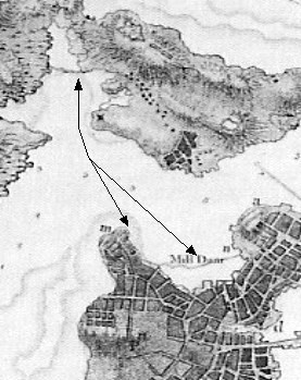
From time to time, the question arises: on which side of the Middlesex Canal was the towpath built? Aficionados are aware that the towpath was on the east side of the canal from the Charlestown Mill Pond north, and that it was on the west side from the Concord River Crossing on to the Merrimack River. So, questions that come immediately to mind include: where did the towpath change over? Did it change sides more than once? How were changes accomplished? And why was this done?
Where did it change? -- Among the corporate records of the Middlesex Canal Company, there is a copy of an 1829 canal survey1 that provides at least partial answers to these questions.
Examination of the survey shows:
Traveling north from the Charles River tidal lock, en route from the Charlestown Mill Pond to the Merrimack River, the towpath remained on the east side of the canal for about 11¾ miles, to Carters Accommodation Bridge2. This was at a point about 20 chains (1 chain = 66 feet) north of the original site of the Baldwin Mansion.
Here it crossed over to the west side and remained there for only a short distance, a little less than 1¼ miles, to Tays Accommodation Bridge, about two chains south of Tays Tavern.
From Tays Tavern, the towpath remained on the east side of the canal for about 3¼ miles, to an accommodation bridge situated about on the line between two property owners, i.e. the families Walker and Carter, at a point about 10 chains beyond the 16 mile marker; or about 26 chains north of Gillis Lock.
From above Gillis Lock, the towpath ran on the west side of the canal, crossed the Concord River on the floating towpath3 and remained on the west side for the remaining distance to the Merrimack River.
So, the rough tally is that the towpath was on the east side of the canal for about 15 miles of the distance from the Charles River to the Merrimack; and on the west side for about 12¼ miles.
How were the changes accomplished? -- There is a related question, how did the tow animals get from one side of the canal to the other without stretching the towline over a bridge at each of the crossings?
Except that we know the changes were made at accommodation bridges (such dual use bridges were also referred to as Change Bridges), and the survey tends to confirm this, nothing more has been found in the Middlesex Canal Companys records to explain how changes were made on this canal.4 But, Loammi Baldwins (the Supervisor of Constructions) mentor was William Weston, an English canal engineer, and so it seems reasonable to assume an answer based upon how this was done on the English canals.
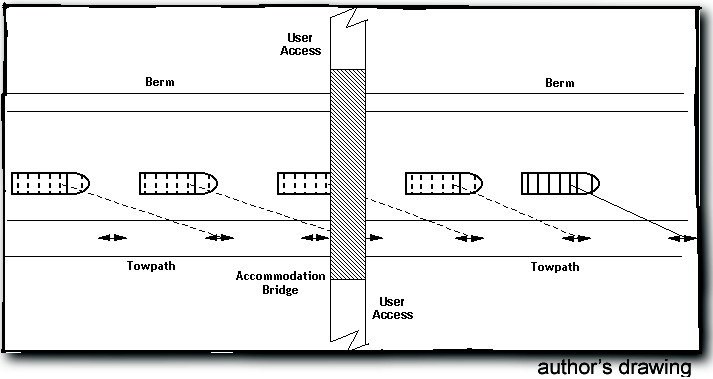
Figure 1: Accommodation Bridge and the path of travel used to avoid connecting the towline
First, it is useful to understand that the accommodation bridges passed over both the canal channel and the towpath, as shown in Figure 1. Said another way, the towpath did not "sweep out" to pass around the end of bridge, while the channel passed under, as this would have resulted in the towline passing over the bridge. This was done so that it would not be necessary to disconnect and reconnect the towline at each bridge. Considering that there were almost 50 such bridges on the Middlesex Canal, this was a serious time-saver for the boatmen. (See also the inset "How important was it " on the second page following.)
Where it became necessary to change the towpath from one side of the canal channel to the other, a "single-petal cloverleaf" was commonly used on one side of a change bridge, with a "U-shaped" return path on the other. By this means, the object under tow, the tow-animal and the towline all ended up on the correct side of the bridge.
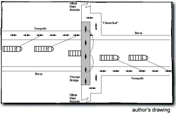
Figure 2: Change Bridge with Cloverleaf and Return Path and the path of travel to move from one side of the channel to the other.
Figure 2 shows this arrangement, and the path of the tow animal (either a horse or oxen, on the Middlesex Canal). If traveling left to right, the tow animal would pass beneath the change bridge, then turn away from the canal to walk up onto and across the bridge. Upon reaching the end, the animal would turn to walk back down to the towpath on the opposite side, where it would resume traveling in the direction it had been going. Using this procedure, very little time was lost and it was never necessary to detach and reattach the towline.
If traveling right to left, the tow animal proceeded through the above sequence in reverse.
Why were these changes made?
Nothing has yet been found in surviving documentation to directly answer this question. But one approach to try to answer it would be to look for reasons in the 1829 survey. Of course, this will yield possible reasons, but not necessarily THE reasons. And theres the additional question - what, exactly, should one look for?
To develop a "what to look for" guide, inputs were solicited from members of other canal societies - through the American Canal Society - to determine why the towpaths of their respective canals were changed from one side to the other. Responses generally fell into two categories: to yield to or take advantage of terrain and rivers - with construction economy being a major subset; and to avoid obstructions or enable facilities to be built on the side of the canal opposite the towpath.
To take each of these down one more level:
How important was it to avoid disconnecting and reconnecting a towline? It is difficult to assign a value to this, but consider that, at some sites in England where space was severely constrained, and thus the towpath had to pass around the end of a bridge, change bridges were sometimes cantilevered from one side of the canal only. From a single abutment, these bridges passed all the way across the channel so as to not quite touch the abutment on the other side. This left a slight gap between the end of the bridge and the opposite side through which the towline could be passed. In other places, two half-bridge sections were cantilevered out from each side, so as to not quite meet in the center. The gap between the two bridge sections was made just large enough to pass a towline through. All that said, nevertheless there were places where detaching and reattaching a towline was unavoidable. If the tow (i.e., a boat, raft, or band of rafts) was such that it would continue to glide forward on its own momentum, then the towline could be detached, the tow animal walked across (or under) the channel to the other side, and the towline tossed back to the tow boatmen to be reattached. If the tow did not have sufficient momentum to continue on, such as at a bridge by a lock, sometimes a monkeys fist, or equivalent, would be attached to (or tied into) the towline. From one side of the bridge, the towline, with this heavy knot on the end, would be swung back and forth below the bridge, gaining both line length and momentum with each swing, until the line was long enough and had enough momentum to fly up on the opposite side of the bridge. With the towline thus extended beneath the bridge, it was then tossed back to the tow boatmen to be reattached. |
To yield to or take advantage of terrain and rivers -- the berm side of a canal was often allowed to extend into hills to save the cost of constructing a berm bank. And, rather than incur the expense of cutting into a hillside to provide space for the towpath, it made sense to construct it on the built up side. This also gave "level walkers" easy access to the vulnerable side of the canal, to inspect for leakage and other problems. -- When a canal crossed a river valley (e.g., on an aqueduct) and proceeded along the side of the hill opposite, it was essential to have the towpath change sides too. This was usually done at the most convenient point, such as a lock or accommodation bridge. -- Changing sides was also necessary if the canal crossed a slack-water. (A "slack-water" is a pool, basin or lake impounded behind a dam, so called because the current within is slight.) to keep the bridge upstream of the tow; or if the canal water course entered a river and proceeded along a slack-water. If it stayed on the same side of the river, it would be necessary to cross the canal on entering the slack-water and again where the canal left the slack-water. (The change was usually done at a lock or guard lock.)
To enable (or avoid existing) structure or facilities construction on the opposite side -- This allowed port facilities, landings and basins to be built on the berm side. -- Similarly, it was done to facilitate the connection of towpaths at a canal junction. -- And it was done to avoid a prior structure, or if a landowner objected.
How many of these situations appear on the 1829 survey? -- In the 11 plus mile stretch between the southern terminus and the point where the change was made, the towpath was on the east side of the canal almost certainly because both the Charlestown Mill Pond (where timber and other goods brought down the canal were held until they could be disposed of) and Horn Pond and the Horn Pond feeder canal (the source of auxiliary water for the canals eastern division) were on the west side.
In the area between seven and eight miles north, roughly between Gardners and Stone Locks, the canal passed through both cuts and swampy land. The survey suggests that in some of these, high ground may have been used in place of constructing a berm. In others, berm may not have been built at all, allowing the water course to extend into co-level ponds, which resulted in natural basins and/or a very irregularly shaped channel in several places.
Also, if a towpath was constructed along the Medford Branch Canal, then, when that branch was constructed a few years later, having the Middlesex towpath on the east side would have facilitated merging the branch canal towpath with it.
In the mile-plus section between Carters and Tays bridges, no compelling features are shown in the survey to suggest why the towpath was moved to the west side. The change was made near the north end of Loammi Baldwins own property, and so the question arises of the change having been made for the chief engineers personal gain. But this doesnt appear to be the case; the change was made well north of Baldwins home and so it is difficult to see why moving the towpath would produce any gain not easily attainable by simply crossing over Baldwins accommodation bridge; a bridge that also carried a significant road across the canal, and thus was not even placed there for his exclusive use.
There is an interesting geological feature, once called Tays Hill, near the north end of this stretch. It is a mound or cone that rises quite sharply from the surrounding land, and the historical record indicates that there was a pond at the top of it. Contemporary local people refer to it as an extinct volcano. But a local geologist insists that there has been no volcanic activity in this area for more than a million years, and all remnants from that period were scraped clean during the ice age, tens of thousands of years ago. Apparently there is a lot of basalt ledge in this area. Whether this had anything to do with the location of the towpath, or not, is not known.
The towpath returned to the east side of the canal just south of William Tays Tavern. Crossing at this point may well have been driven by the fact that, in addition to providing hospitality services to canal travelers, Tays was also a horse changing station and thus a facility of considerable importance to the daily operation of the canal.
There is high ground on the west side of the channel in approximately the lower half of the three miles north of Tays, which suggests that construction economies may have been realized by not having to build a berm in these areas. Beyond this, continuing north, the ground is shown as being swampy, and what should be the berm side is shown as being very irregular. This suggests that a berm wall may not have been constructed in this area either, to achieve additional construction economies.
Why the towpath changed from the east to the west side of the channel just north of the 16 mile mark is not apparent. And this remains the case for the next six miles. But from this point on, the dominant reason for having it on the west side, where the canal crossed the Concord River slack-water, would almost certainly have been to place the route of boats and rafts under tow on the downstream side of the floating towpath. This insured that the river current would naturally hold them away from the towpath while being towed across.
The towpath conveniently remained on the west side past the basin where boats and rafts were held awaiting their turn to be towed across the Concord. Later, from 1837 on, this basin also served as a turning basin for boats traveling through Red Lock and on down the Concord River to the mills at Lowell. Continuing north, there was no reason to change to the other side, and so the towpath remained on the west side for the remaining distance to Middlesex Village.
Within Middlesex Village, retaining the towpath on the west side of the canal kept it opposite Hunnewell and Gores Chelmsford Glass Works, also the Bent and Bush Hat Factory, two Chelmsford industries that were erected on the east side of the canal around the same time that the canal itself was built.
| Consisting of warehousing facilities and a dock, the Middlesex Canal Companys Landings served the public. Customers could take goods there to be shipped on the canal and river network, and retrieve items that had been shipped to them. |
Of interest, when a company-owned Landing (see inset, opposite) was eventually built here, in East Chelmsford, it was located on the west side of the canal, at the very end of the towpath immediately above the Merrimack River locks. This was the Middlesex Canal Companys Landing #8. This being the case, was a new towpath then constructed on the east side of the Merrimack Locks, so that tow animals could assist boats and rafts to negotiate the three-lock staircase?
Having completed this south-to-north examination of the factors that may have influenced the location of the towpath along the canal, a new thought arose - though the survey proceeded south-to-north, the canal was actually constructed north-to-south. Would the findings be any different if the survey was examined proceeding in the opposite direction, more aligned with the order in which obstructions, impediments or other influences were encountered? That task will be left for the reader to investigate!
Endnotes:
1 Baldwin, James Fowle; Hand drawn notes from his survey of the Middlesex Canal, 1829; 50 pages. Corporate Records of the Middlesex Canal Company; archived in the Patrick Mogan Center, Lowell MA
2 In Hahn and Kemps "Canal Terminology of the United States", West Virginia University Institute for the History of Technology and Industrial Archaeology, 1999, p-1, an accommodation bridge is defined as one used to carry the towpath from one side of the canal to the other, designed and constructed to take the tow animal and the towline to the other side of the canal without unhitching the boat. On the Middlesex Canal, this term was used more broadly and included bridges that carried established roads over the canal, as well as those that enabled property owners (e.g., farmers) to access parcels of their land cut off by the canal.
3 The Floating Towpath was, essentially, a floating bridge that carried the towpath across the Concord River.
4 Lawrences manuscript contains a reference to the need for capstones to reduce the debris kicked into the canal by the tow animals, where the towpath passed beneath accommodation bridges.
THE CANAL THAT BISECTED BOSTON
by David Dettinger
This account was originally presented on November 5, 2000 at the Boston National Park in the Charlestown Navy Yard by its author, David Dettinger. It was the eighth in a series of events celebrating the Bicentennial Decade of the Middlesex Canal, and was titled "On to Boston: Extending the Middlesex Canal." Mr. Dettinger is a director and a proprietor of the Middlesex Canal Association. He has incorporated some minor changes based on information received since that presentation.
For someone exploring present-day Boston it may be hard to believe that at one time a sea-level canal passed through the center, connecting the Charles River with the waterfront. Constructed beginning in 1810, such a canal operated for about 25 years, finally giving way to a railway, also gone. To trace its origin we must revisit some of the significant events in the early history of Boston.
Boston was established by the English in 1630 as a base for the Massachusetts Bay Colony. The determining factor was its fine harbor, one of the finest on the Atlantic coast, protected by offshore islands, deep enough for any ship, and offering a waterfront with ample locations for docks.
A navigational map dated 1781 shows at its center the Shawmut Peninsula (renamed Boston by the British), attached on the south by a neck of land to Roxbury. On the east is the Town Cove with its waterfront on the harbor. On the west is the Back Bay, formed as part of the Charles River estuary. The North Cove at the top of the peninsula faces the Charlestown Peninsula across the Charles. To the north of Charlestown lies the Mystic River, which turns to enter the harbor beside the Charles.
The little settlement of Boston prospered, so much so that a wealthy merchant class arose. Commerce with other colonies was minor; in fact, it was actively discouraged by the Crown. Boston could be thought of as a "tight little island".
The American Revolution brought significant changes for Boston. The new republic faced a fresh challenge: how to build a viable unified country out of thirteen former British colonies. As insisted by the Federalists, notably Alexander Hamilton, this demanded close connections among the states plus greatly improved access to the interior.
This urgent requirement for better transportation came at a time before railroads and when roads were notoriously poor, often little more than dirt tracks through the wilderness. The preferred solution was waterways. In this respect, Boston found itself at a disadvantage relative to other Atlantic ports. For example, New York had the Hudson River, Philadelphia the Delaware, Baltimore the Susquehanna. Boston had but the Charles River, navigable only as far as Watertown, and the Mystic River, navigable only as far as Medford. The only sizable river near Boston was the Merrimack, coming down out of New Hampshire. However, as it reaches the Massachusetts line it turns due east, emptying into the ocean at Newburyport; it is 25 miles north of Boston at its nearest.
In Europe the need had been met with networks of canals, and the technology had become quite advanced. In Boston many canal proposals were floated, most of them totally unreasonable. One scheme caught the attention of an enterprising lawyer, James Sullivan, later to become governor of the Commonwealth, and for whom Sullivan Square is named. Its objective was to construct a waterway all the way from Boston to Concord, New Hampshire, thereby opening up the "North Country" with its rich resources.
The specific concept was to construct a canal towpath through Middlesex County, thereby connecting the Mystic River at Medford with the Merrimack River just above the formidable Pawtucket Falls at present-day Lowell; the southern terminus was subsequently changed to the Charles River at Charlestown. From its northern terminus the waterway would continue up the Merrimack to Concord. (Some effort had already gone into overcoming the main obstacles along the river, but further improvement would be necessary.) From the southern terminus in Charlestown boats could be drawn across the Charles to the Boston peninsula.
Sullivan recruited a group of "Proprietors", drafted an Act, and shepherded it through the Massachusetts General Court in early 1793. The Act authorized such a private venture; the canal was to be completed in ten years. He proceeded to form the Middlesex Canal Company to implement it, and served as its President for the rest of his life.
Under the supervision of Col. Loammi Baldwin of Woburn the Canal was completed on schedule and began operation in 1804. It was a marvel of its day, hand dug for 27 miles with 20 locks and numerous aqueducts, culverts, bridges and landings.
At Charlestown the Canal entered a tidal millpond formed by walling off a bay of the Charles River estuary, which had been constructed in the years 1670-75 to furnish power for mills along the western shore to grind corn and saw lumber. Building the wall for the milldam was no mean feat. Its overall length was over a half a mile, and its height great enough to extend above high tide. It must have been a communal effort, since there appear to have been only about 200 able-bodied men in Charlestown at the time. The wall was probably constructed by laying rocks and adding fill out from the shore, perhaps on a footing of timber. However it was done, the wall lasted 150 years with occasional repairs.
|
|
Interrupting this wall was a platform of mills plus a gate permitting the pond to be filled at high tide and held at that level. The water could then be directed onto the mill wheels when the tide was out; boats could enter or leave by the gate at flood tide. The mill might operate several hours out of the 12-hour tide cycle each day. Unfortunately, there are no explicit records to support this scenario, only various clues. Later the gate was replaced by a lock to permit boats to pass at other times.
With foresight the Middlesex Canal Company purchased the entire millpond complex and set about improving all its features. For example, to cross the pond a floating towpath had been introduced between the Canal entry and the existing lock; this was replaced by a permanent embankment. The lock itself was improved; the mills were renovated and access improved; the dam was reinforced where needed.
From the millpond Boston destinations could be reached by either of two options, that is, by loading cargo onto wagons and hauling them across Charlestown to the bridge which had opened in 1786; incidentally, Col. Baldwin had been active in its design and construction. Alternatively, canal boats could be pulled across the Charles River to a wharf and warehouse rented on the northern tip of the Shawmut Peninsula. From here it was about a mile to the center of Boston on a rough road.
Crossing the Charles River was not a trivial matter. Canal boats, long and narrow, were designed to be towed, not navigated in open water with current, wind, and along a curving route, as shown in Figure 1. Rather, they must be hauled hand-by-hand along a cable called a "warp". However, such a cable must not interfere with traffic on the river itself.
Col. Baldwins solution, shown in Figure 2, was ingenious. He placed buoys along the route tethered to anchors below. A heavy iron ring was slipped over each tether, and the cable was attached to each ring in turn. With this arrangement the cable would rise as it was being pulled, bringing the ring with it; after passing a buoy the ring would pull the cable to the bottom, again, out of the way of passing boats.
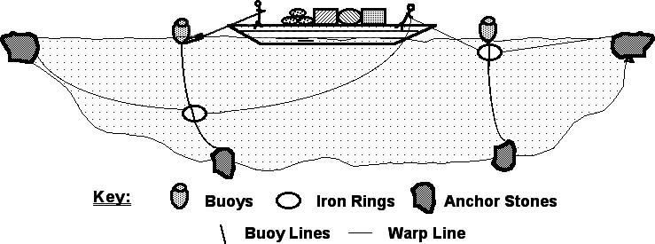
Figure 2 - Editor's Concept of Baldwin's Warp Line Arrangement
The Canal Company had a standing offer to supply a "pilot" for each passage at the price of one dollar. Presumably the pilot did not actually pull the boat, but was responsible for controlling the warp, adjusting for current, tidal flow and wind, and assuring that the boat never went adrift.
Either of the above options had the serious disadvantage of requiring cargo to be loaded on wagons and hauled to their final destination in Boston. Fortunately, a third option appeared a few years later. This option is the feature of this account; once again an historical review is in order.
First, some topography: Let us examine a map of Boston as it appeared in 1635, see Figure 3/1a, page 19. Beside the North End lies the North Cove. Within the Cove is shown a swampy island which extends almost across the opening. A trail ran through it apparently used by the Indians. As early as 1630 a settler named Crabtree observed that this island could be extended on both ends to form a tidal millpond such as the one previously described, and he set about doing it. However, as you can imagine it was far too much for an individual and he had to give up.
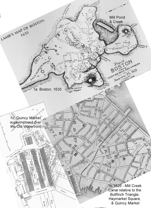
Figure 3 - Boston Mill Pond (1635); Mill Creek Canal rel. to prominent (1826)
landmarks; and Quincy Market rel. to the Canal and Waterfront
Thirteen years later the project was taken up by Henry Symons and five associates. They secured the grant of this cove from the town on the condition that they construct a Mill Pond and erect one or more mills. They were to provide a floodgate ten feet wide for the passage of boats, and had the right to cut a channel through the marshy portion of the pond to a creek leading southeast to the Town Cove, providing they erected passable ways for crossing by horse and cart. The group proceeded to complete the dam and to dig out what became known as Mill Creek leading to the waterfronts. They erected three mills, one at the western end of the dam, one at the northeast end, and one at the junction of the Mill Pond with Mill Creek.
Mill operations continued for almost 150 years during which there were various changes in the mills. The mills at the western end of the dam, which had its own floodgate was the first to cease operation. The mill at the northeast end of the dam burned about the time of the Revolution and was replaced by three others. Two mills were located near the entrance to Mill Creek, also later replaced.
Over time, the Mill Pond itself began to become polluted. When the western mill closed, its gate remained closed, and that corner of the pond began to develop a stench due to debris that was carelessly dumped in, including dead animals and local privy runoff. Likewise other parts of the pond became filthy, bringing complaints from neighboring settlers. This unhealthy condition joined with another factor to force a significant change to this segment of the route in the early 1800s. With the steady growth of Boston, land was becoming scarce. On all sides land making was in progress. The Mill Pond inevitably became a target both because of its central location and because of its stench, which in those days was presumed to breed disease. Resistance came from those who felt that the mills were an asset, as well as from those who thought open bodies of water should be preserved as a source of cooling breezes.
In 1804, a town committee was appointed to investigate the possibility and desirability of filling the Millpond. Before the committee was ready to report, the mill owners, who were the successors of the ponds original proprietors, obtained an Act of the legislature incorporating them as the Boston Mill Corporation (BMC), with the clear intention of filling the pond. Spirited discussion at meetings and articles in the press followed, debating the desirability of filling and the constraints that should apply. A fresh element that entered into consideration was the completion in 1803 of the Middlesex Canal. It became evident a canal through Boston would constitute a logical extension, providing direct access to the waterfront and to businesses along the way.
Finally in 1807, an agreement was reached between the town and the BMC on filling, subject to various restrictions, such as requiring the BMC to pay the cost of filling, reserving some land for town use, providing proper sewers, streets, etc. One special provision was that Mill Creek would be kept open and extended through the (filled) pond to the Charles River. According to Dr. Nancy Seasholes, an archeologist who specializes in the topographical history of Boston, this latter provision was directly attributable to the recent completion of the Middlesex Canal and the desire to extend its benefits all the way to the Boston waterfront and intermediate locations, notably Haymarket Square.
A street plan was laid out by Charles Bulfinch, a member of the committee of selectmen, to include the canal; a sketch shows his concept superimposed on the boundaries of the pond. The plan is basically a triangle with the canal at its center, its base on Causeway Street, and its apex at Haymarket Square. Note that the Mill Creek continues through to the waterfront thereby completing the bisection of Boston. A later map, see Figure 3/1b, page 19, shows the plan as it was implemented.
Completion of the project, including filling the entire area and adding bridges, etc., took almost 21 years; that is a story in itself. However, the canal was a priority, and the first contract for its construction was let in 1809; other contracts followed. The walls were built free-standing across the Mill Pond, 40 feet apart over most of the 1,000 foot length, narrower at Causeway Street; the width was later increased to 60 feet.
As to the structure of the canal walls, my information comes from Dr. Seasholes dissertation at Boston University, dealing with land making in Boston. Typically, such walls were built of stone on a footing of timbers. The footing consisted of "grillages", that is, latticed rafts of pine pinned together with oak treenails, or trunnels as they were called, and floated into position. These were set into the bottom except where the clay was sufficiently firm to support the wall. On top was a "battered" wall of rock laced with horizontal and vertical timbers. Presumably the grillages, never being exposed to the air, last indefinitely and prevent individual rocks from sinking into the mud; the weight of the rocks holds them in place.
The level of water in the canal was a matter of concern. It would be convenient for users if the water were constantly held at a few feet below the top of the walls; this would require a guard lock at each end to adjust for the variation of tide level. However, a source of water at the highest level is required to replenish the water released during each locking operation. No such source existed in mid-Boston. The result is clear: the canal must operate at sea level. In short, the water level is governed by the rise and fall of the tide, and the walls must be high enough to contain high tide.
The contract for the walls called for them to be 8 feet high. Considering that the average range of height of tide is 9 feet in Boston harbor and often more, it is evident that boats will be stranded at low tide. However, they can be moved half of the time or more, which is not unreasonable since the process of loading takes time, and boats can be left for another cycle.
At its eastern end this canal was joined to Mill Creek, already deepened and improved. Together these two segments provided a waterway from the Charles River to the Boston waterfront. In so doing they actually bisected Boston during their active years, about 25 in all. Crossing the canal required bridges, half a dozen or so. Three were drawbridges; the others were permanent or makeshift.
The completion of the canal through Boston brought immediate benefits to Boston merchants. It also lifted the spirits of the investors of the Middlesex Canal as it multiplied the traffic and increased revenues. In 1819 for the first time the Canal Company was able to pay a dividend; this continued for almost 20 years. Unfortunately, this revenue never fully recovered the full cost of construction, maintenance, and operation.
Traffic on Mill Creek was never great. Besides being constrained by tide level, it reached the harbor at a single location from which most of its cargo must be transported to other wharves. Finally, increasingly business was principally transacted near Haymarket. As the creek became polluted and fell into disuse there came pressure to fill it and use its land for other purposes. When Faneuil Market (later renamed Quincy Market) was begun in 1824 under Mayor Josiah Quincy, it was necessary to relocate the end of Mill Creek to another wharf; see Figure 3/1c, page 19. A few years later the entire creek was filled in. Incidentally, the granite for the market was transported down the Middlesex Canal and through Mill Creek.
The main portion of the Boston Canal ceased operation twenty years later, losing its traffic to that nemesis of canals, the railroad. In 1845, the Boston and Maine Railroad acquired the right of way, built a depot at Haymarket Square, filled the Canal, and laid track in its place, thus bringing our saga to an end, though Middlesex Canal itself hung on for several more years before its demise.
By the middle of the 19th century the Cross Boston Canal had passed into history almost forgotten. Nevertheless, together with bridges across the Charles River, it had broken the image of Boston as a "tight little island", and played on instrumental role in building a thriving commercial hub at its center. Furthermore, in enabling a continuous waterway from Boston to central New Hampshire, it established a corridor that fostered healthy development all along its route.
What can one find today? Gone is the Millpond. Gone is the canal that crossed it. Gone is Mill Creek. All that remains to remind us of that early period are street names: Causeway Street, the boundary of the Millpond; Traverse Street, the location of one of the three drawbridges that crossed the canal; and Canal Street, once the towpath of the Cross Boston canal.
References:
Baker Library, Historical Collections of the; Harvard School of Business Administration. Folder on Boston Mill Corporation formed in 1804; legal and administrative matters.
Berkland, Ellen, Boston City Archeologist. Various materials including excerpts from part 3, "The Urban Environment of Boston" by Joseph F. Balicki, published by the Journal of Historical Archeology 1998, an 1836 survey including the intersection of Causeway Street and the Boston canal, and photographs of an archeological excavation at the junction of Mill Creek with the Boston Mill Pond, 2000.
Drake, Samuel A., "Old Landmarks and Historic Personages of Boston", James R. Osgood and Co., 1873.
Drummey, Peter, Librarian, Massachusetts Historical Society files related to this topic, 2000.
Elia, Ricardo J., et al., "Archeological Investigations of the Central Artery/Third Harbor Tunnel Project in Boston, Massachusetts", Phases I and II, printed via Boston University in 1989 and 1999 respectively. Also "Archeological Data Recovery", Volume I, the Mill Pond Site, prepared by Timelines, Littleton, Massachusetts, 2000.
Krieger, Alex and David Cobb with Amy Turner, contributing essays by David Bosse ... [et al.]; vignettes accompanying the plates, Anne Mackin; map descriptions, Nancy S. Seasholes and David Cobb, "Mapping Boston", MIT Press, 1999.
MacQuarrie, Brian, "Little dig, big find", The Boston Globe, January 14, 2000.
Savage, Edward K., "5000 Boston Events 1630 to 1880", Tolman and White, 1884.
Seasholes, Nancy S., "Landmaking and the Process of Urbanization", Doctoral dissertation, Boston University, 1993.
Shurtleff, Nathaniel, "A Topographical and Historical Description of Boston", third edition, Rockwell and Churchill, City Printers, 1891.
Weston, George F., Jr., "Boston Ways: High, By and Folk", second edition, Harvard University Press, 1957.
Whitehill, Walter M., "Boston: a Topographical History", second edition, Harvard University Press, 1968.
Bibliography:
Archives of the Middlesex Canal Company, Mogan Cultural Center, Lowell, Massachusetts.
Clarke, Mary Stetson, "The Old Middlesex Canal", Hilltop Press, Melrose, Massachusetts, 1974.
Historical records and books at local libraries: Charlestown, Medford, Winchester, and Woburn.
Lawrence, Lewis M., "The Middlesex Canal", 1942, printed by the Middlesex Canal Association, 1977.
Linscott, Louis, prints by; "The Middlesex Canal", published by the Middlesex Canal Association, 1978.
Records of the National Historical Park, Lowell, Massachusetts.
Roberts, Christopher, "The Middlesex Canal 1793-1860", Harvard University Press, 1938.
Seaburg, Carl and Alan, with Thomas Dahill, "The Incredible Ditch: A Bicentennial History of the Middlesex Canal", Anne Miniver Press for the Medford Historical Society, 1997.
Towpath Topics (originally Canal News), the newsletter of the Middlesex Canal Association, October 1963 to date.
VerPlanck, Burt, "Middlesex Canal Guide and Maps", Middlesex Canal Association, 1996.
THE ANCHOR STONE
a photo by Howard Winkler
The Floating Towpath once spanned the Concord River in North Billerica. Photographs of the stone, with heavy iron rings, that is believed to be the anchor stone for the Floating Towpath, are usually taken from the shore. Last winter, Howard walked out onto the river ice to take a picture from a different perspective, shown below.
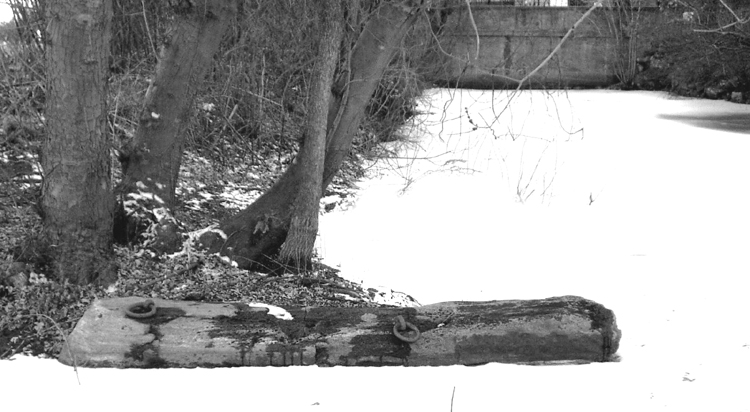
Floating Towpath Anchor Stone and Canal Channel
GEORGE WASHINGTON AND THE POTOMAC CANAL
by Jim Peters
Few sixty eight year old people take it upon themselves to spec out a new canal. Looking for a canal route is usually an arduous process, involving more than two people, who must climb hills and mountains, transport canoes and boats across streams, portaging difficult streams. It takes sheer muscle, something most elderly citizens may have, but they probably would not use it to track down a canal route to the Potomac.
After his presidency, George Washington had time on his hands and a goal in his mind. He wanted to investigate the possibilities of putting a canal from the Potomac River into the western lands. Unlike the Middlesex Canal, this canal would be constructed using existing brooks and streams, use explosives in its manufacture because the Appalachian Mountain valley chosen was very rocky and very steep.
Washington was a remarkable president. He established precedence in a number of ways, from being addressed simply as "Mr. President," to establishing the method of addressing the Congress as required by the Constitution. He was not exactly the most unbiased canal builder however. He detoured to check on his personal western lands, and found people occupying his land in Pennsylvania. It did not really slow his progress however, and he was genuinely interested in the idea of establishing a Potomac Canal.
He and his companions, including his personal slave, started on their journey in individual canoes paddling up the Potomac, looking for a place to enter into a canal route. It did not take them long to find a place. He found an inlet that looked comfortably large enough to be a canal entrance. He paddled up that stream until it became unnavigable. Faced with the choice of either continuing on or looking for another inlet, Washington chose to continue on. The location of this small river was exactly on the route that Washington envisioned.
Washington continued on a tour of the stream, making notes in his journal, drawing his interpretations of what the locks would look like. After navigating miles into the wilderness, he gave the order to turn back. He had decided that he had found the Potomac Canal. Pieces of the canal are still in existence, and it is a National Park. The man I feel was our greatest President had used his few months left to chart a very difficult course for the new Potomac Canal.
RUM
Excerpt from A History of the World in Six Glasses, Walker and
Company, 2006, pp. 113-118., copyright 2005 by Tom Standage
Rum was a staple of the taverns that served the canal boatmen and travelers. Unable to make beer or wine of any quality, the early colonists stumble upon a new drink which some authors regard as the drink that built America.
"Amid [the New World] hardship, securing a reliable supply of alcohol assumed great importance. ... When a third English colony was established, in Massachusetts, the settlers made sure they brought plenty of beer. In 1628 the ship Arbella, which carried the leader of the Puritan colonists, John Winthrop, had among its provisions 42 Tonnes of Beere, or about ten thousand gallons.
"Owing to the harsh climate, European cereal crops, which could be used to make beer, were very difficult to cultivate. Rather than rely on imported beer from England, the settlers tried to make their own from corn, spruce tips, twigs, maple sap, pumpkins, and apple pairings. ... The colonists [also] tried to introduce European vines, but their efforts failed due to the climate, disease, and, since they were from northern Europe, lack of wine-making experience. They tried to make wine from local grapes instead, but the result was revolting. ...
"Everything changed in the second half of the seventeenth century, however, when rum became available. It was far cheaper than brandy, since it was made from leftover molasses rather than expensive wine, and did not have to be shipped across the Atlantic. ... Rum was stronger too, ... [and] quickly established itself as the North American colonists favorite drink.
"From the late seventeenth century, rum formed the basis of a thriving industry, as New England merchants--primarily in Salem, Newport, Medford, and Boston--began to import raw molasses rather than rum and do the distilling themselves. ... In 1733 ... rum accounted for 80 percent of [New Englands] exports, ... [and] was being consumed at a rate of nearly four American gallons per year for every man, woman, and child in the colonies. ... In addition to selling rum for local consumption, the New England distillers found a ready market among slave traders, for whom rum had become the preferred form of alcoholic currency with which to purchase slaves on Africas west coast.
"It played an important role in election campaigns: When George Washington ran for election to Virginias local assembly, the House of Burgesses, in 1758, his campaign team handed out twenty-eight gallons of rum, fifty gallons of rum punch, thirty-four of wine, forty- six of beer, and two of cider--in a county with only 391 voters."
QUIBBLES, QUARRELS AND QUESTIONS!
by Bill Gerber
Please let me know if discussions of this nature are of interest to you. And if you have information to contribute, by all means, please do contact me.
Having researched the Middlesex and related canals from many sources, over several decades, Ive found it interesting to reread both Christopher Roberts and Lewis Lawrences books. I now have a considerably different perspective on some of the things they wrote, and understand other things that meant nothing when I read these books the first time.
At the outset, understand that I have great respect and admiration for the work that both Roberts and Lawrence did. They were thorough and careful researchers; and I aspire to someday do as well as they did. Their books are among the very best sources of information available about the canal system.
But, that said, there are a few their observations and conclusions that I now disagree with. Following are discussions of some of the points of disagreement, significant and otherwise. Also included are questions about several items that I still dont understand. If any readers have leads to sources for "enlightenment", Id appreciate your pointing me toward them.
QUIBBLE - On page 101, Christopher Roberts states "about one year after the date of the contract with Bemis and Stearns for stone laying at the locks, the superintendent made the following laconic entry in his diary: "Opened Lock and Canal Merrimack River and the first lock broak and failed""; this from a diary entry dated October 18, 1796: Baldwin MSS. - Lewis Lawrence echoed this observation on page 24 of his manuscript. Both Roberts and Lawrence are correct in their observation that a lock failed on that date. However, it was not a lock belonging to the Middlesex Canal Company. This was the day that the Proprietors of Locks and Canals on Merrimack River (PLC/M) attempted to open the Pawtucket Canal, and it was on this day that one of THEIR locks failed. (See my article entitled "The Pawtucket Canal at Lowell" in the March 2004 issue of Towpath Topics (www.middlesexcanal.org/towpath). The Merrimack Proprietors referred to this as a "disagreeable incident"; but a Chelmsford reporter wrote a colorful description suggestive of disaster only narrowly avoided.)
It should not be surprising that Baldwin (Supervisor for construction of the Middlesex Canal) would make an observation relating to the Pawtucket Canal, he was involved with it as well. According to Baldwin family papers (at Baker Library, Harvard University), Loammi Baldwin held 13 shares of stock in the other (PLC/M) company; also, in the fall of 1794, he headed a team that surveyed the six rapids below Pawtucket Falls for the PLC/M. (See my article in the March 2004 issue of Towpath Topics entitled "The Proprietors of Locks and Canals on the Merrimack River: What else did they do?"). Of course, the work on the Pawtucket Canal was running considerably ahead of what Baldwin was doing on the Middlesex, and both companies were learning as they worked. As an engineer, Baldwin would also have had an intense interest in the work the PLC/M was doing, the means by which they were doing it, the extent of their success, whatever mistakes they made and the lessons they were learning from all they did.
QUARREL AND QUESTIONS - Tom Raphael and I have long argued about the Concord River - was it ever "improved" to support commercial shipping on it, and if so, how far up the river did this go? Documentation on this is sparse, but there is some to be found.
The original act of incorporation stated: "That said Proprietors ... shall be empowered to render the waters of Concord River boatable as far as Sudbury causeway, and as much farther as the same can be usefully improved for that end, and to open any canal, at any place in the said County of Middlesex, that may be necessary to connect the said Concord River with the said Middlesex Canal, for that purpose, and ...." (Where was or is the Sudbury causeway? Is this by the current Rt. 117 bridge?)
Most of us are aware that the floating towpath could be opened so that logs could be passed through, and any debris that got caught on the upstream side could be cleared. Boats could also pass through this opening, but did any do so?
It is also fairly common knowledge that, in 1837 (two years after the Rail Road opened between Boston and Lowell), the Middlesex Canal Company built Red Lock to allow boats, etc., to depart the canal to travel down the lower Concord River to Lowell. So, Red Lock and the provision to open the towpath, together, provided a path around the dam at North Billerica and thereby enabled travel on a considerable length of the river. Were these the full extent of the "improvements"?
Apparently not. In his report to the Proprietors, John L. Sullivan noted a number of expenditures for the year 1808. Under "For improvements" he included: "Clearing the falls of Concord River, so as to connect it with the Canal ... $86.14. (Lawrence, p - 52.) Then, in his 1810 report to the Proprietors, Sullivan gave a detailed accounting of expenses for the preceding year. One item on his list was "Work done on the falls of Concord River to make them more practicable, $15.02. (Lawrence, p - 55.) In 1818, reviewing his ten years of service as agent for the canal, Sullivan made the following observation: "... and Concord River, before mentioned as appurtenant to the Canal, was opened for ten miles to old Concord, and such toll levied as the business would bear." (Lawrence, p - 61.) This last point is restated as follows: "Above the dam, the river "was opened for ten miles to old Concord, and such toll levied as the business would bear." (Lawrence, p - 119)
However, Lawrence also offers conflicting information on this point. On pg. 53, he states "It does not seem that much serious effort was made by the proprietors to make the Concord River navigable for canal boats. Its infrequent use is indicated by H.D. Thoreau who said formerly, once in a year or two, one of these boats came up the Concord River, and was seen stealing mysteriously through the meadows and past village. Nevertheless the General Court continued to extend the time for rendering the Concord River "boatable and navigable." An act was passed June 19, 1809, extending the time four years, to June 22, 1813, and on February 26, 1813, it was extended five years more, to June 22, 1818. Then the effort was abandoned."
The above raises several questions.
If the river was "improved" as far as "old Concord", why did the General Court continue to extend the time to render it "boatable and navigable"? Did they expect additional work on the part of the river that had already been opened? Or were they looking for the navigable portion to be extended, e.g., up the Sudbury and/or Assabet Rivers, perhaps to Sudbury and/or Acton? Extension to Sudbury causeway certainly would have been consistent with the authorization granted in the original Act of Incorporation.
How much credence should one give to Thoreaus observation? How much of the daily life of Concord was he in position to observe? How much of daily activity beyond Concord was he able to observe?
Furthermore, "old Concord" was not the only point along that length of river. The Concord River is crossed by several significant roads which probably had equivalents at the time the canal was operating. These include Rt. 3A in Billerica; Rt. 4 near the Billerica/Bedford Line; Rt. 225 near the Carlisle/Bedford line; Rt. 126 (extended) on the north side of Concord; and Rts. 2A and 62 in Concord itself. (These crossings show up on an 1860 map, prepared as part of a law suite against those who acquired and raised the level of the mill dam at the Concord Crossing and thereby flooded out farm fields upstream.) Were cargoes exchanged at any of these points? (Are any of you aware of any historical records that would shed light on any of the above?)
QUESTION - In Lawrence, p-33 - mention is made of the Packet Boat "Washington" departing from "Beachum Landing" in Charlestown (bound for Middlesex Village). On p-43, the locations of eight landings are listed. Among these are: "Landing Number One, on the east side of the Mill-Pond in Charlestown" and "Landing Number Two, at the Bason in Charlestown". So, is Beachum Landing the same as either of these numbered landings; or is it an adjunct to either of the same; or is it a third landing, perhaps erected specifically to accommodate the passenger trade? Did Beachums Landing belong to the MCC? Or was it a private enterprise?
QUESTION - In the booklet "The Middlesex Canal; prints by Louis Linscott", p-3, there is the following caption - "Abbotts Landing; Samuel Abbotts landing and lumber yard on the Middlesex Canal was located approximately in back of the present Woburn Public Library and was a shipping and receiving point for building materials and other merchandise. Loads of bark were brought down the canal from New Hampshire and teamed by ox cart to the tanneries of Woburn." Linscotts drawing of Abbotts Landing appears on page eight of the same booklet. In Lawrence, p-43, the list cited above includes "Landing Number Five, to be established in Woburn, ... ." So, is Abbotts Landing the same as Landing Number Five; or is it yet another landing, perhaps a private landing?
QUESTION - Who owned the various other landings, particularly those along the Merrimack? Which were privately owned; and by who? Which were MCC owned? Which were "jointly" owned; and who owned which parts?
At the Registry of Deeds, in Nashua, for the year 1806 (yes, 1806!), there are records of John Langdon Sullivan having purchased a hundred or so acres of land, at each of multiple sites in New Hampshire. Ive not yet cross checked these, but I expect that most of these will correlate with the Landing sites that Sullivan claimed as his own. These included: Litchfield, Merrimack, Dunbarton, Pembroke, Concord and East Concord. Sullivan also claimed ownership of Landings in Boston, Charlestown, Medford, Billerica, and Chelmsford. At each of his Landings, Sullivan claims to have built warehouses, tenements, barns, workshops and docks.
There is also an entry indicating that Sullivan later transferred ownership of one (repeat, only ONE) of these tracts to the Merrimack Boating Company (MBC). And still later indications that he transferred ownership of all, or most of, the other Landings on the Merrimack to his brother, William Sullivan. I suspect that the transfer was done in 1823, to keep the properties from being seized by the MCC for non-payment of debt. (The debt was incurred from lockage fees incurred during the feud between the MBC and the Union Boating Company, that resulted in the bankruptcy of both companies, and the formation of the Boston and Concord Boating Company which assimilated the assets of both.)
Contrast Sullivans claims and actions, with his statement reported in Lawrence, p - 56, part of his 1810 report to the Proprietors, of 1809 expenditures, "The boating up river has been attended at the outset with some little extra expense - in fixing the landing places at Tyngsboro and Nashawa with the proper machinery to unload, and in assisting the neighborhood to erect stores at them for the reception of goods."
So, who owned what? How many Landings were there - public, private and joint? (And do any of you have experience that could be applied to sorting out the ownership of each of the sites?)
Thats all of this for now; but there may be more in the next issue!
 |
Web Site - As you may have noted from the mast-head, www.middlesexcanal.org is the URL for the Middlesex Canal Associations web site. Our webmaster, Robert Winters, keeps the site up to date, thus events and sometimes articles and other information will often appear there before we can get it to you through Towpath Topics. Please check the site from time to time for new entries.
Museum & Reardon Room Rental - The facility is available at very reasonable rates for private affairs, and for non-profit organizations meetings. The conference room holds up to 60 people and includes access to a kitchen and rest rooms. For details and additional information please contact the museum at 978-670-2740.
Canal Game and Puzzle - The National Canal Museum has made a canal related game and a puzzle available on their web site http://www.canals.org/funandgames/. These include: a Boat Captains Game (Can you run a canal shipping business successfully?) and a Canal Lock Puzzle (Would you know how to construct a canal lock and make it work?). Give them a try.
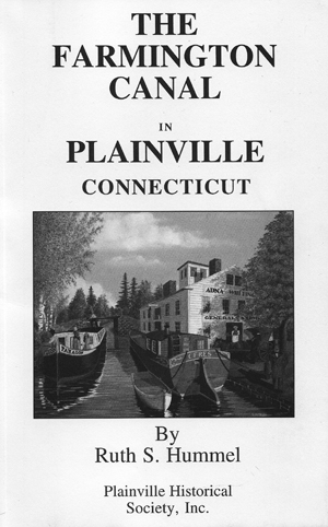
Book - Farmington Canal - Theres a new canal book out. Written by Ruth S. Hummel; printed by the Briarwood Printing Company of Plainville, 2007, and issued by the Plainville Historical Society, its title is "The Farmington Canal in Plainville Connecticut".
Ruth has been President of the PHS for many years, and an aficionado of the Farmingon (aka the New Haven - North Hampton) Canal for almost as long. In that time, and successively with partners Mel Schneidermeyer and Dr. Carl Walter, she has taken a strong hand in: restoring a segment of the canal in Plainville, publishing a map of the entire Farmington Canal, collecting and studying photos, diaries, artifacts and stories about it, and leading tours to key sites. She has written over 900 articles on local history for local newspapers and over 90 shows for public access TV (locally Nutmeg, Channel 5). Many years ago, we brought her to Lowell, MA, to lecture to participants of an American Canal Society weekend to explore the canals of New England. (Hers was a hard act to follow!) Now, at age 77, she has written a book to make the stories she has learned more widely available.
Clearly, the book is a wonderful compilation of Ruths stories, drawn from the scope and depth of decades of research. It is an "easy read", with 27 short chapters and illustrations about the planning and construction of the canal, the boats, the people, the "tow critters", the cargos hauled and other uses, and finally its demise; in short, just about every conceivable aspect of the old Farmington Canal. And Ruths observations pertain to life on many other of our historic canals as well.
The book (available from the PHS, 29 Pierce Street, Plainville CT 06062; $15 mail order, plus $2.50 S&H, or call 860-747-6577 for price and ordering) is a "must-have" for anyone interested in the history of the canal era in the USA.
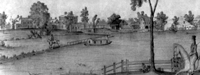
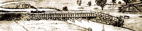
Front page - Excerpt from a watercolor painted by Jabez W Ward Barton, c. 1825, entitled "View from William Rogers House". Shown, looking west, is the Floating Towpath with the Packet George Washington being towed across the Concord River at North Billerica.
Back Page - Excerpt from an August 1818 drawing of the Steam Towboat Merrimack crossing the original Medford Aqueduct (artist unknown).
This issue of Towpath Topics was edited by Bill Gerber with production assistance by Robert Winters.