![]()

Middlesex Canal Association P. 0. Box 333 Billerica, Massachusetts 01821
VOL. 27, NO.
1
OCTOBER, 1988
NOVEMBER 13 MEETING AND PROGRAM
THE MIDDLESEX CANAL ASSOCIATION will hold a general meeting at the Lowell State Heritage Park, Mack Building, 25 Shattuck Street, Lowell, at 2:00pm on Sunday, November 13, 1988, in the upstairs meeting room.
Our featured speaker will be Mr. Richard Scott, the Park Supervisor. Mr. Scott will talk about the Lowell State Heritage Park, and its role in interpreting and presenting the living history of the area. The meeting will be followed by refreshments and an opportunity to socialize with other members and guests.
To get to the Mack Building, follow the brown park signs from Route 3 and the Lowell Connector. Parking is available in the lot near the National Park Visitors’ Center. The Mack Building is two doors away from the canal workers’ memorial fountain, and has a huge drive wheel on display at its entrance.
All are welcome to come meet our speaker, and to learn about the Middlesex Canal Association and its efforts to promote awareness of our regional heritage.
PRESIDENT’S MESSAGE
MIDDLESEX CANAL HERITAGE PARK? Part Two.
In the previous issue of Towpath Topics, I wrote that the Canal’s coming bicentennial would be a good occasion for a project such as creating a Middlesex Canal Heritage Park.
The months since that article have underscored the statement that "there will never be a better time" for such a project. In fact, disturbing events show that now may be the only time for such an idea. A portion of the canal earthworks next to the Shawsheen aqueduct was bulldozed this summer, virtually eliminating any possibility of improving access to this site or expanding it. Portions under roads in Billerica have been redug and replaced with culverts and rip rap, obscuring original stonework and changing the water flow and retention patterns.
This issue includes reprints of some portions of the Middlesex Canal Heritage Park Feasibility Study prepared in 1980. It proposed a multi-purpose park in the area of the Mill Pond on the Concord River in North Billerica, with museum facilities and an interpretive center (for both canal and mill history). The stretches of canal originating here could be included in the park and eventually restored to recreational use, including the lovely wooded sections of canal which our annual fall walk follows.
Our speaker on September 25 described ambitious and exciting plans for the Blackstone State Heritage Park. Our November meeting will be at (and about) the State Heritage Park in Lowell. These projects took vision.
I urge you to read these pages with an imaginative eye. Envision what you would like the next generation to see, when they come to look for the route of the old Middlesex Canal.
What will we accomplish between now and 1993? Can we set a goal for ourselves, and reach it? Will the Middlesex Canal become a lost memory, or a living one?
Let your officers and directors know what you think.
David Allan Fitch, President
Middlesex Canal Association
SPEAKERS NEEDED
Do you know of someone who’d make an interesting speaker for a meeting of the Middlesex Canal Association? (Including yourself?) Or is there some special author or scholar you’ve always wanted an excuse to call and introduce yourself to? Why not invite him or her to be a guest speaker at one of our meetings? For further information, or just to pass along your ideas, please contact any of our association’s Officers and Directors.
TENNESSEE GAS COMPANY TO RESTORE SECTION OF MIDDLESEX CANAL
by Betty M. Bigwood
In 1950 a 12-inch gas main was installed parallel to Butters Row in the Town of Wilmington. The process transsected a section of the Middlesex Canal bed – and leveled it. Attempts to have it restored went unresolved.
Now, the Tennessee Gas Company needs to install an additional pipeline 24 inches in diameter parallel to the existing one. While the Middlesex Canal Association cannot stop "progress," we now feel it to be an excellent opportunity to restore the berm and towpath.
Indeed, on July 21, 1988, at the Wilmington Town Hall, six members representing the Tennessee Gas Company and seven Directors of the Middlesex Canal Association (B. Bigwood, D. Dettinger, L. Eno, D. Fitch, N. Hazen, F. and B. VerPlanck) met informally to discuss various problems connected with restoring the Canal. We took this opportunity to explain what we wanted – a full restoration with respect to contour (but not to require a clay liner).
On September 6, 1988, four representatives of the Tennessee Gas Company, Libby Sabounjian from the Wilmington Conservation Department, Donald G. Jones, Assistant Director of the Office of Public Archaeology, and Betty Bigwood of the MCA, met at the Butters Row site to discuss the manner of procedure. Mr. Jones wanted to be present during any backhoe work to take soil samples. General agreement was reached to place the pipeline five feet away from the existing one to prevent further damage to the Canal, but ten feet away in all other areas. After the pipeline is fully installed, Tennessee Gas will bring in fill to replace the contour of both the berm and towpath.
On September 21, 1988, Betty Bigwood met with the Wilmington Conservation Board to enlist their aid and support. They agreed to back this restoration.
Maps, cross sections of the Canal, and a description of the quality of fill have been sent to Stone Webster, engineers for the Tennessee Gas Company.
It is our great hope that an area now an eyesore can be restored to its original beauty. This undertaking is planned for spring/summer of 1989.
BRITISH INLAND WATERWAYS HOLIDAY CRUISES
We recently received a brochure from this company describing trips available on their boats. "These inland waterways have retained the atmosphere of an age gone by.... This is a holiday for those who take pleasure in the quieter things of life, in the beauty of everchanging landscape, ... in good food and the company of interesting and friendly people." The cost this year was approximately $450 per person per week, which includes board. The address is Inland Waterway Holiday Cruises, Preston Brook, Runcorn, Cheshire, WA7 3AL, England. If you wish simply to look at the brochure for 1988, please call Martha Hazen at 617/484-3634.
EXCERPTS FROM THE MIDDLESEX CANAL HERITAGE PARE FEASIBILITY STUDY (1980)
Prepared for: Middlesex Canal Commission
Prepared by: Metropolitan Area Planning Council, Northern Middlesex Area
Commission
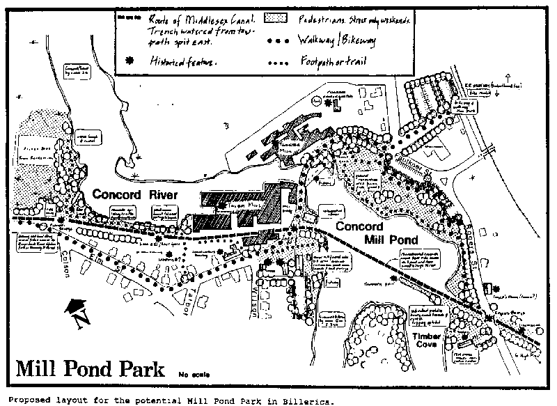
Segment BIL-5. The Concord Mill Pond/Talbot Mill Area
Overview
The Concord Mill Pond/Talbot Mill area has exceptional potential for historical
recognition and recreation on a very broad scale. Because the locale has been
prominent in industrial and transportation development since the early
eighteenth century, there is a wealth of historical material for preservation.
This same material could be the stimulus for a range of interpretive exhibits
that enliven North Billerica’s past and relate it to the larger New England
scene.
The river is currently enjoyed for boating; swimming will once again be possible as the river is cleaned up. Some of the shoreline is devoted to parking, nonetheless, the pond edges of the lots and the bridge/dam area are well-used fishing spots. From any shore vantage point – looking down the river, across at the mills, or from the mills to the woods on the other side, the prospect is tranquil and rural. Neither too large, nor too small, the pond seems prototypical of the classical New England mill pond. The quality of this tranquil landscape has remarkable strength. It is enough to overcome the incongruously heavy traffic on the bridge, the bustle of the crammed parking lots, and the deterioration of large parts of the surrounding residential neighborhood.
The area offers the additional benefit and developmental challenge of the current enterprises at the Talbot and Faulkner Mills. Both support ongoing enterprises that continue the industrial heritage of the area. It is their presence that will bring the exhibits and demonstrations that could be established here to life: these industries provide a reference point that sets earlier operations in the same place into a framework of evolving reality: replacing the glamour of nostalgia for the more valuable truth of daily work.
Any recreational or educational activity that is conducted here must take these current businesses with the utmost seriousness. It is possible, with good will and clear goals on all sides, to create a situation in which a variety of desirable goals that will benefit all elements of the area can be achieved.
Study Focus
This study focuses in particular on clarifying the image of the Middlesex Canal
in North Billerica. It will not attempt to lay a foundation for broadly based
neighborhood revitalization nor will it seek to establish long range goals. It
will recommend first, minimal steps that could be taken immediately to heighten
the visibility of the Canal in the area. These actions will have very little
impact on the community as it stands, requiring only the addition of signs and
limited development of existing public or semi-public land.
This is a sober and realistic set of recommendations. Much more could be accomplished. An additional description, more for the sake of showing one alternative that could be developed around Mill Pond than to present a firm recommendation, is included. It is hoped that it will stimulate interest in carrying out a more extensive, more inclusive study of the Mill Village area to determine how land use around the pond might be reorganized to preserve its character, enhance the sense of the past, and provide amenity for those who live and work there.
The Mill Pond Area Today
The Mill Pond was formed, at least as long ago as 1807, by damming the Concord
River flowing north to the Merrimack at a point just above the falls. The dam
and falls can be seen today from the Faulkner Street bridge crossing the river
just below them. The bridge is handsome, but narrow for the workday traffic that
crowds it. On either side of the bridge stand the late nineteenth century brick
mill buildings and their later additions, replacing earlier grist, saw, and
fulling mills. The Talbot Mill houses the Cambridge Tool and Die Co. as well as
several smaller ventures. The Faulkner Mill is still a textile concern. Parking
spreads out from both mill complexes around the pond and back along the Concord
River.
The predominantly residential surrounding neighborhood includes two churches, a school, and a fire house. There is a spa-type grocery store. Some of the housing on Wilson Street and Talbot Avenue was built by the Talbots in the late nineteenth century to house mill workers. Today it has deteriorated and, like much of the rest of the area, is rental housing owned by absentee landlords.
Behind the firehouse on the shores of the river is a 29-acre tract of town-owned land, known as the Old Filter Bed Land. The Kohlraush playing fields serve the Talbot School. Nearby is the Talbot Oval, a half-acre Town common area. The Billerica Historical Society owns a small (1 acre), but key tract off Rogers Street on the river near the old towpath spit.
The Boston/Lowell train stop is a five-minute walk from the Talbot Mill building. Another bridge crosses the Concord half a mile to the south of Pollard Avenue.
The Canal and the Mill Pond
The Canal came in from the east, under Rogers Street near a house, still
standing, that may have been used as a tavern. A spit of land built out into the
Mill Pond led to the floating towpath – a bridge enabling a draft animal to
pull its canal boat to the other side, just south of where the Talbot Mill now
stands. The canal went through what is now the mill yard, running east towards
the fire house and down Lowell Street.
There were several locks along this section to control the water from the Concord and to permit rafts of timber to bypass the dam and falls on their Concord River route to the saw mill. Some of the guard lock in the mill yard is visible; an anchor bolt for the floating towpath can also be seen. The canal trench in the mill area is filled.
Two canal related structures still stand on the west side of the river. The Mears Tavern, at the corner of Elm and Wilson and the ‘Canal Block’ of housing across the street, by all accounts a particularly outstanding example of its type, are worth preservation effort.
Basic Recommendations
A first step in raising consciousness concerning the Canal will be to locate
signs and interpretive material in key locations.
1. Rogers Street crossing.
Standard Canal identification sign.
Additional information regarding Rogers House, Rogers Bridge, and the nearby Lincoln Lock.2. Faulkner Street crossing.
Standard Canal identification sign.
Plaque on mill wall referencing guard lock.3. Bridge area.
Weatherproof diagrams explaining canal route and technology in as much detail as possible. Could be placed on shore below parking lot with path leading by the sluice gate.
4. Land owned by Historical Society.
The land could be developed by volunteer labor with path and cleared picnic area on river’s edge. Signs and weatherproof drawings to explain the towpath arrangement could be installed. Possibly a simple one sheet guide to the area could be placed in a weatherproof dispenser. The guide would include a map showing the trails along the extant canal trench both east and west.
In addition, small signs should identify the location of the Raft Gate, the Red Lock, the Farmer’s Bridge, and the Landing. Extant buildings with canal history: The Mears Tavern and the ‘Canal Block’ housing should be marked.
These measures would complement a walkway/bikeway developed along the eastern and western spurs of the canal. Some of the suggestions described below could be added: the reconstructed floating towpath would be especially interesting. Bike rental could be available at the railroad station, a canoe launch could be easily constructed on the Historical society land.
Mill Pond Park
The above are minimal measures. The importance of the entire area in terms of
Massachusetts history is great – it has been suggested for, and should be
nominated to the National Register of Historic Places. It has good potential for
development as a State Heritage Park. The following description offers one
complete alternative for increasing public awareness of the historical assets of
the Mill Pond area and for permitting increased public use of the land around
the pond. Sub-parts of this plan can be developed independently.
The plan assumes that two major changes in the use of land will be possible. Both of these have been successfully adopted elsewhere. The first change dedicates the edges of the Mill Pond and a buffer strip to natural scenery and public use; the second, that Faulkner Street between Wilson Street and Carleton Street be closed to traffic at certain times.
The Mill Pond is the focus of activity. Two centers for interpretive exhibits, recreational facilities, and food services are connected by paths around and across the pond. These in turn connect to paths along the linear segments of the canal linking the park to more distant facilities.
It is possible to approach the park in several ways. The rail traveler heading for Lowell might stop here on the way, rent a bicycle and, after spending some time in the park, bicycle the six miles to Lowell, returning by train, or by bike and train. The canoeist from up the Concord or from Lowell will find canoe launches available. Visitors coming by car, or workers in the sill buildings will find parking along the edge of Faulkner Street, near the railroad station off Wilson Street, and in other small lots throughout the area. Bicycle and canoe rental are provided for those who wish to change their mode of transportation on arrival.
Foot paths lace the natural area round the pond. A traffic-free zone in front of the mill buildings and across the bridge is established on weekends. Traffic is routed over the Pollard Avenue bridge half a mile south.
The towpath exhibit area includes picnic tables, a snack-type restaurant, rest rooms, a logging exhibit, and individual paddle boats to be rented by the hour for exploring Timber Cove, as well as canoe rental for the more serious boater. The focus in this area is on the Canal and its towpath. Canal boat replicas could travel the reconstructed Canal section east to High Street and back, crossing the Mill Pond to the larger interpretive center.
Here is a larger, more formal restaurant and an indoor museum devoted to both mill and canal, emphasizing their relationship to similar developments in other parts of New England, especially Lowell.
The foot path system surrounds the Mill Pond and follows the old canal route to the Filter Bed recreational land with its canoe launch and rental. There is a portage around Talbot Mill starting near the site of the Raft Gate, ending at the mouth of the canal. The foot path rejoins the canal on Lowell Street. The bikeway follows Faulkner Street to Lowell Street beyond the firehouse and continues westward towards Chelmsford.
This low-key park would be a distinct recreational asset in North Billerica. It would best be carried out as part of a comprehensive neighborhood plan.
APRIL MEETING:
EARLY HISTORY OF CIVIL ENGINEERING IN THE UNITED STATES
WITH REFERENCE TO CANAL DESIGN AND CONSTRUCTION
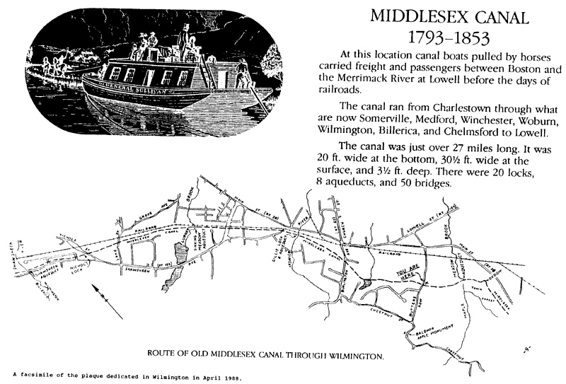
On Sunday, April 10, members of the Middlesex Canal Association met at St. Thomas Catholic Church function hall in Wilmington to hear a talk on the early history and development of civil engineering in the United States, with particular reference to canal design and construction, given by Daniel L. Schodek, Professor of Architectural Technology at Harvard University. Prof. Schodek is the author of the book "Landmarks in American Civil Engineering" published by the MIT Press, which includes a chapter on early canals, including the Middlesex Canal.
Prof. Schodek discussed the contributions of many engineers both in this country and in England, many years before formal civil engineering training was available. Canal work was one of the main places these engineers learned their trade; the Erie Canal could be called America’s first great "School of Engineering."
In France, by contrast, where the 16th and 17th centuries saw the erection of great public works of stone, a school for roads and bridges was founded in the 18th century. When, in 1794, Thayer founded the U. S. Military Academy in West Point to educate engineers for public as well as military tasks, he studied the system in France. Later, Rensselaer Polytechnic Institute and Union College initiated engineering programs to feed engineers to the Erie Canal work. Finally, the year 1852 saw the founding of the American Society of Civil Engineers.
So, when Loammi Baldwin first started on the Middlesex Canal in the 1790’s, he had no source for trained engineers; but, by the 1850’s, thanks in large part to the enthusiasm for canal building in this country, the formal field of civil engineering was firmly established.
WILMINGTON SPRING CANAL WALK
contributed by Betty M. Bigwood
Our Spring Canal Walk was held on Saturday, April 30 at 2pm. The clouds parted and the sun came through for a good outing.
About 50 of us met in the parking lot of the Wilmington Town Park and walked over to Patches Pond Road. On the way, we passed the famous oxbow turn where the canal bent sharply to bypass a hill of granite, and saw the rope marks made by the boats pulling at an angle. We also visited the Maple Meadow Aqueduct site – indeed, Wilmington is the location of four of the eight aqueducts. Since Maple Meadow Brook was too full of water to cross, we turned back at this point.
After transferring our cars to Butters Row, we paused for a few moments to pay tribute to a new Canal plaque and monument just off Butters Row. It is one of the plaques placed by funds given to each of the eight towns through which the Canal passed, by the Commonwealth of Massachusetts. The brass plaque here has a map of the Canal in Wilmington, the logo of a horse pulling a canal boat, and Dr. Kopycinski’s concise synopsis of the Canal’s passage (both the logo and Dr. Kopycinski’s text appear on all the plaques).
In celebration of the new plaque, lemonade and chocolate chip cookies were served at the monument site. Afterwards, the walk continued along the Canal section between Butters Row and Maple Meadow, and finally along the remaining section north of Butters Row.
SEPTEMBER MEETING:
BLACKSTONE CANAL HERITAGE STATE PARK
On Sunday, September 25, members of the Middlesex Canal Association met at the Crawford Memorial United Methodist Church in Winchester for a presentation by Monica Fairbairn, Project Manager for the Blackstone Canal Heritage State Park.
After discussing briefly the history of the Heritage State Parks and showing a video presentation on these Parks, Ms. Fairbairn gave us a most absorbing presentation on the efforts that are being made to preserve the remains of the Blackstone Canal and to turn the sites into parks for the enjoyment of all.
The Blackstone River drops 460 feet from its origin in the Worcester area to its mouth in Narragansett Bay. Because of the many falls available for power along the River, textile mills were built along it in the early 19th century, most notably in Pawtucket, RI and Uxbridge, MA. Between 1824 and 1828 the Blackstone Canal was built along the River, making Worcester into a port almost overnight. The Canal met its demise in 1848, partly due to a rivalry among the mills for the water from the Blackstone River, but mainly because of the advent of the Providence and Worcester Railway in 1835. (This should be a familiar story to Middlesex Canal devotees!) The Railroad actually bought the canal out to use part of the towpath as its bed. The Railroad itself suffered later on with the arrival of the internal combustion engine.
In early 1984, funding was authorized for the Blackstone River and Canal to be developed as part of the Heritage State Parks system. The Commonwealth owns 1000 acres of land north and east of Uxbridge, which includes an old mill building and one of the best preserved sections of the old Canal. The Commonwealth has also acquired other pieces of land along the route of the Canal. Rhode Island has plans to continue the park from their border with Massachusetts to make a National Heritage Corridor.
The final goal is to have four Visitors’ Centers, located in Worcester, Uxbridge, Pawtucket (RI), and at the Slater Mill; it is the policy of the Heritage State Parks to locate these in urban areas. The Park also expects to have a horse-drawn canal boat, the Lady Harrington II, in operation in Uxbridge. Its predecessor, the Lady Harrington, was the only passenger boat on the Canal.
There is the inevitable conflict arising between the pressure to build housing and commercial buildings to cope with the prosperity coming to the area, and the drive to preserve as much open space as possible. The Heritage State Park is working to foster cooperation between the Commonwealth and the developers along the Blackstone Valley.
Ms. Fairbairn brought with her a large number of slides which very beautifully illustrated the history of the region and the Blackstone Canal, the steps being taken by the Heritage State Park to restore and beautify the remains of the Canal, and the plans for future preservation and development in the area.
THANKS TO A GOOD FRIEND
The Board wishes to acknowledge Malcolm Choate’s years of faithful service as Treasurer of this organization. Mac "retired" this spring, after serving as Treasurer for 12 years. Thanks, Mac.
ARLINGTON USED TO BE A MIDDLESEX CANAL TOWN
by Howard B. Winkler
Resident of Arlington, Massachusetts
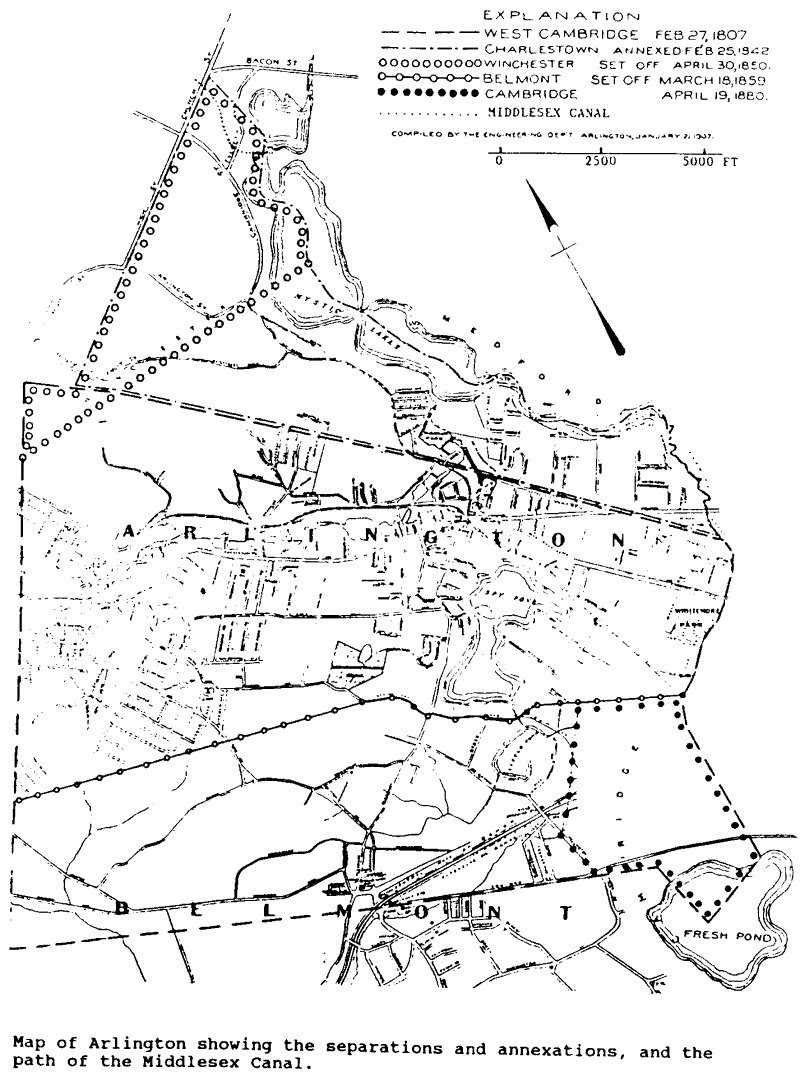
The time line which follows shows that, for a period of eight years during the mid-nineteenth century, the Middlesex Canal passed through what is now the Town of Arlington.
| YEAR |
EVENT |
| 1803 | Middlesex Canal opens to boat traffic. |
| 1807 | The Second Precinct of Cambridge separates and is organized as the Town of West Cambridge. |
| 1842 | A section of the Town of Charlestown is annexed to West Cambridge that includes the Canal north and west from its crossing of the Upper Mystic Lake to Edgewater Place and along Sheffield Road to its intersection with Church Street (using current Winchester place names). The total length of the West Cambridge section of the Canal is about 2,500 feet. |
| 1850 | The Town of Winchester is organized, and a part of Charlestown annexed to West Cambridge which includes the Middlesex Canal is annexed to Winchester. |
| 1853 | The Middlesex Canal is closed to boat traffic. |
| 1867 | The Town of West Cambridge changes its name to Arlington. |
From the above sequence of events it can be concluded that the Middlesex Canal passed through Arlington from 1842 to 1850.
[The accompanying map (from Parker) indicates the separations and annexations. The path of the Middlesex Canal has been added and is shown as a dotted line in the upper left quadrant.]
References
Guide to The Middlesex Canal 1793-1853 by Mary Stetson
Clark.
Town of Arlington, Past and Present by Charles S. Parker.
STRANGER IN A STRANGE LAND
by Jeremy Frankel
[Editor’s note: The following article appeared in American Canals, the Bulletin of the American Canal Society in February 1988 and is reproduced here by permission. Jeremy Frankel gave a presentation to the MCA in February 1988 on canals in Britain.)
As a visitor from England touring America and looking at your canals several curious aspects of the waterways have struck me. It would appear that any canal that exists today in a navigable state in no way resembles the one that was built 200 years ago. The New York State Barge Canal and the Chesapeake and Delaware are typical examples of this category. Otherwise any canal as originally built is generally in a derelict state today, apart from one or two very small sections that have been rewatered. Another facet that astonished me is that apparently there are no surviving examples of original boats, barges or batteaux afloat today.
With these facts in mind and comparing what I have seen with the English canal system it is apparent to me that the people of America, not just canal buffs, are missing out on something very important.
The attitude that seems to prevail whereby derelict waterways are just left as they are to further deteriorate is more than a shame but a criminal negligence of one’s history and heritage. Even if a length of canal is incorporated into a park very little restoration is carried out apart from preventative measures to stabilise dangerous structures. My view is that where it is practical and economically viable, waterways should be restored to a navigable condition so that people can experience for themselves how boatmen navigated along canals and through the locks.
When canals were first constructed they were used purely for commerce moving raw materials like coal, wood, pig-iron and tobacco to towns and returning with manufactured goods. Canals were a watershed in man’s history, be it in England, Europe or America changing the country from an agricultural based society through the industrial revolution to form the basis of the industrial society we now live in.
Canals were probably the last things to be built by man that was in harmony with nature. To see a working canal today in England one can see that the scale is human because man did not possess heavy construction equipment, they were all dug with picks, shovels and wheelbarrows.
They are a monument to the early engineers, surveyors and navvies – the navigators who toiled, sweated and died building embankments, cutting aqueducts, tunnels and locks. That their waterways can still be seen today albeit derelict is a tribute to their skill.
Although the political and financial systems of our countries are different I’m sure a way can be found to combine the abilities of state government, business corporations and the enthusiasm of canal societies to restore some waterways. The expenditure on restoration can be partially offset in the long term by trip-boats, stocking the canal for fishing and charging for rod-licenses. If the length restored is long enough one can rent boats out for personal use.
Promoting the waterway as part of one’s heritage will boost the tourist business along the route – shops, restaurants, hotels and so on. By using them and not fencing them off or metaphorically putting them in glass cases, one can, to borrow the slogan employed by the New York State Department of Transportation to publicise the Erie Barge Canal “experience the legend.”
|
OFFICERS AND DIRECTORS 1988-1989 |
|
|
PRESIDENT VICE-PRESIDENT RECORDING SECRETARY CORRESPONDING SECRETARY TREASURER/MEMBERSHIP EDITOR, TOWPATH TOPICS |
DIRECTORS: Malcolm Choate Jane B. Drury Wilbar M. Hoxie Daniel Silverman Frances B. VerPlanck
|