Middlesex Canal Association P.O. Box 333 Billerica, Massachusetts 01821
www.middlesexcanal.org
Middlesex Canal Association P.O. Box 333 Billerica, Massachusetts 01821
www.middlesexcanal.org
| Volume 62 No. 1 | October 2023 |
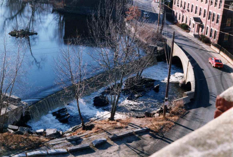
Talbot Mill Dam
This picture was taken in 1998 from the tower of the Faulkner Mill. The Talbot Mill dam has been the center of many controversies
over the past three centuries. Much of this issue is devoted to presenting an opposition to the proposed removal of the dam.
Picture Courtesy of Alec Ingraham
MCA Sponsored Events – 2023 Schedule
Fall Walk, 1:30pm, Sunday, October 15, 2023
Meet at the southeast corner of the parking lot at the Woburn Cinemas,
25 Middlesex Canal Drive, Woburn, MA 01801
Fall Meeting, 1:00pm, Sunday, October 29, 2023
Speaker: Howard Winkler Topic: “My Sixty Years as an MCA Member”
Location: TBA Details will be posted on the MCA website
The Visitors Center/Museum is open Saturday and Sunday, Noon – 4:00pm, except on a holiday.
The Board of Directors meets the 1st Wednesday of each month, 3:30-5:30pm, except July and August.
Check the MCA website for updated information during the COVID-19 pandemic.
TABLE OF CONTENTS
MCA Sponsored Events and Directions to the MCA Museum and Visitors’ Center
President’s Message from J. Jeremiah Breen
MCA Letter in Opposition to the Talbot Mill Dam Removal - by Betty Bigwood
Letter in Opposition to the Talbot Mill Dam Removal - by Bob LeBlanc
Letter in Opposition to the Talbot Mill Dam Removal - by Bill Kuttner
Letter Concerning the Removal of the Talbot Mill Dam - by Bob Thorson
2023 MCA Fall Bicycle Ride Report - by Bill Kuttner
Creating the Documentary: Journey along the Middlesex Canal - by Roger Hagopian
The Allen Tavern - by Alec Ingraham
Editors’ Letter
Dear Readers,
In this issue we will focus primarily on the Talbot Mill Dam and the efforts to demolish it. The first item is a letter sent to Brona Simon of the Massachusetts Historical Commission from Betty Bigwood. It is an impassioned history of the MCA’s attempt to establish at this historic site a museum dedicated to the Middlesex Canal.
The second entry is a response to MEPA by Bob LeBlanc about the removal. He asks questions and makes comments on the survey and studies by proponents of the removal. MCA member Bill Kuttner has also submitted a letter originally submitted to MEPA, stressing that with the loss of the dam would also be the loss of the fabric needed to tell the story of the Mill Pond and dam to future generations. The last item by Robert Thorson, former MCA meeting speaker, on historic attempts to remove the dam, comparing them to the current MEPA project.
Finally, for a change of pace we have reports about from the MCA Annual meeting and the 2023 Fall Bicycle Ride, a construction update of progress at the proposed museum, a very interesting piece by Roger Hagopian recounting his experiences filming his often viewed Middlesex Canal Documentary and finally an article concerning the story of the Allen Tavern in East Billerica. As usual, dates of upcoming events, directions and miscellany are included.
Thanks for Reading,
The Editors
MCA Sponsored Events
Fall Meeting: The MCA Fall Meeting will be held on October 29, 2023 at 1:00pm at the Middlesex Canal Museum and Visitors’ Center, 71 Faulkner Street, North Billerica, MA 01862. After a brief business meeting Howard Winkler will speak on his experiences during his sixty-year membership in the MCA. In addition to serving many years as the organization’s treasurer, Howard is a frequent contributor to Towpath Topics and is currently serving on the MCA Board as corresponding secretary. It proves to be a fascinating talk. Don’t miss it! (This event may be available on ZOOM. Please access the MCA website, www.middlesexcanal.org, for additional information.)
Note: Walks and Bicycle Tours: For more detailed information please access the MCA website at www.middlesexcanal.org about a week prior to the scheduled event.
Directions to Museum: 71 Faulkner Street in North Billerica, MA
By Car
From Rte. 128/95
Take Route 3 (Northwest Expressway) toward Nashua, to Exit 78 (formerly Exit 28) “Treble Cove Road, North Billerica, Carlisle”. At the end of the ramp, turn left onto Treble Cove Road toward North Billerica. At about ¾ mile, bear left at the fork. After another ¼ mile, at the traffic light, cross straight over Route 3A (Boston Road). Go about ¼ mile to a 3-way fork; take the middle road (Talbot Avenue) which will put St. Andrew’s Church on your left. Go ¼ mile to a stop sign and bear right onto Old Elm Street. Go about ¼ mile to the bridge over the Concord River, where Old Elm Street becomes Faulkner Street; the Museum is on your left and you can park across the street on your right, just beyond the bridge. Watch out crossing the street!
From I-495
Take Exit 91 (formerly Exit 37) North Billerica, then south roughly 2 plus miles to the stop sign at Mt. Pleasant Street, turn right, then bear right at the Y, go 700’ and turn left into the parking lot. The Museum is across the street (Faulkner Street). To get to the Visitor Center/Museum enter through the center door of the Faulkner Mill and proceed to the end of the hall.
By Train
The Lowell Commuter line runs between Lowell and Boston’s North Station. From the station side of the tracks at North Billerica, the Museum is a 3-minute walk down Station Street and Faulkner Street on the right side.
President’s Message, “Woburn and the Middlesex Canal”
by J. Breen
The water highway of the Middlesex Canal made possible rapid development of Middlesex County as shown in population growth recorded in the US census. The table below records that Middlesex County grew 4x faster than Essex County between 1810 and 1820 and more than 2x times faster for the next 20 years.
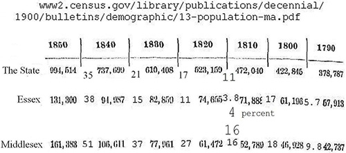
Population Growth of Essex and Middlesex Counties Compared
One source of growth was the tanning industry in Woburn. Prior to low cost transportation, each farming village would have a tannery using the hides of local cattle and tanbark from nearby producing leather for local use.1 With the Middlesex Canal, bark from the forests of New Hampshire could be delivered at low cost and hides from around the world could be delivered at low cost from Boston. The brig Pilgrim, built in Medford in 1825, sailed to Mexico’s California in 1834 to buy hides, a voyage described in the Harvard Classics book, Two Years Before the Mast by Richard Henry Dana, Jr. Woburn had the businessmen to build tanneries using the Middlesex Canal and water from Woburn’s many brooks.2 With leather produced in Woburn and later in neighboring cities, Boston had become by 1935 the largest sole-leather market in the world.3 Massachusetts likely became a shoe manufacturing center because the Middlesex Canal was the beginning of major leather manufacturing.
Notes:
1. “That is, there were no particular places in the United States where the tanning industry was centralized. There was no system of transportation whereby hides could be gathered from far and wide into one center, tanned, and shipped to the manufacturers of leather goods.” Riley, George Archibald, “History of Tanning in the State of Maine” (1935), Page 27-134pdf. Electronic Theses and Dissertations. 2419. http://digitalcommons.library.umaine.edu/etd/2419
2. Woburn: A Leather City, a documentary by John McElhiney, (6) Woburn: A Leather City - YouTube.
3. “Boston has the largest sole-leather market in the world”. Riley, op. cit, page 87- 134pdf.
MCA Letter in Opposition to the Talbot Mill Dam Removal
by Betty Bigwood
Dear Massachusetts Historical Director Brona Simon, Billerica Town Manager John C. Curran and MEPA,
The Middlesex Canal Association, The Middlesex Canal Commission and the Town of Billerica Historic Districts Commission oppose “the Talbot Mills Dam Removal on the Concord River.”
This letter is written to explain why.
HISTORICAL
In 2014, the Middlesex Canal Association accepted from Pace Industries an 1870’s brick building at 2 Old Elm in much need of repair to be our new Museum. We have operated a museum at 71 Faulkner Street since 2001.
It is important to realize that it was the site and not the building at 2 Old Elm that drew us to start this adventure. The building, constructed decades after the Canal ceased operation, is to be the museum and visitor center, which will tell the story of the site. We accepted legally 2 Old Elm in March of 2014. In December of 2014 - ~8 months later - NOAA under the leadership of Eric Hutchins filed for their removal permit. Mr. Hutchins is now in semiretirement.
The building is part of the Faulkner/ Talbot Mill and Talbot Dam Historic Mill Districts and is on the National Register. It sits aside the Concord River Mill Pond – our summit pond - which was created by the Talbot Dam in 1707 to serve the people of Billerica as a grist and saw mill.
The dam was elevated by a few inches to serve as the primary water supply for the operation of the entire Middlesex Canal in 1794. The entire Middlesex Canal was designated a National Register site in 2009. It was here that Loammi Baldwin officiated at the ground breaking for the Middlesex Canal in 1793. Today, for all to see, are the rock and rings which served as attachments for the famous Floating Towpath which carried horses pulling boats across the Concord River. The tip of the spicule of land across the river served as the other attachment. It is an official Native American historical site. Most important is the dam itself which produced the force to operate the mills and the water to operate the Middlesex Canal. The dam is the centerpiece of the entire site.
What better protection could one have than three intersecting National Register Historic Site designations? Has appropriate thought been given to the many hours of hard work and dedication that have been given to accomplish this? Leonard Harmon, our first Middlesex Canal Commission chairman, and Thomas Raphael, MCC Chairman, spent years of their lives documenting the Middlesex Canal. Rep James R Miceli provided funding to pay for the mapping etc to accomplish this. What an asset to have in the Town of Billerica!
When we accepted 2 Old Elm as our future museum it was the site, not the building, which was our main emphasis. The building was to be used to tell the story with pictures and exhibits. Yet the site is at risk today.
The area between the Pollard Street Bridge and the dam will be unrecognizable - just a fraction of its former self – if the dam were to be destroyed. There is a 50 foot strip of land around most of the Mill Pond which we own. The legal implications of this are yet to be determined.
THE TALBOT DAM IS NOT ALONE
As the fish swim up the Concord River, they encounter two formidable dams; the Essex dam which provides power for the Town of Lawrence and the Centennial Dam which produces power for Lowell. They both have fish ladders. There has been no real attempt to repair and bring up to date the Centennial dam. In fact there has been little study of the numbers of fish which pass these two ladders. Do the small numbers not support the removal of the Talbot dam? Is that the rationale for not doing the study?
WATER SUPPLY TO THE TOWN OF BILLERICA
The entire water supply for the Town of Billerica – all 42,112 residents who expect water to pour from the tap when it is turned on - comes from the Concord River. Their multimillion-dollar water treatment plant is only 15-16 years old.
A good water supply is and will be a challenging necessity forever. Gomez and Sullivan, engineers for NOAA’s removal, say that the Fordway bar is “unlikely “ to disappear. Is unlikely acceptable? No guarantee? At a recent (7-18-23) open meeting at the dam Eric Hutchins said for all to hear that “We will never allow anything to happen to Billerica’s water supply” in response to TM Curran’s question “what about our water supply”. Get that in writing please.
The Talbot dam provides an additional four-inch water cushion of comfort above the Fordway Bar which should not be taken lightly. I think that NOAA should be required to carry a multi-million dollar bond for the next 100 years to protect the Town of Billerica in case Gomez and Sullivan’s calculations are incorrect.
DAM OWNERSHIP
The Martin Family owns the Talbot dam. There were numerous meetings with former MCC chairman Thomas Raphael over the years as a solution was sought. They want to rid themselves of the cost and liability for their descendants. While we sympathize, there must be a better way than to destroy such a magnificent structure with such a rich history. The loss to the Town of Billerica is huge. The loss to the Middlesex Canal Association and Commission would be overwhelming.
THE MIDDLESEX CANAL MUSEUM AND VISITOR CENTER AT 2 OLD ELM
When we decided to accept the building at 2 Old Elm, we took on a large responsibility. It has been far more expensive to restore than we ever thought possible. We have now spent in excess of $2,000,000. Covid, inflation and delays have been pricey. Members of the Middlesex Canal Association have put countless hours into the project. Our Contractor, Bill Cogley, frequently reminds us how much we have saved by doing the project in house – especially when you compare the cost of restoring the Howe School. ($10,000,000) Our property – the area between the Pollard Street Bridge and the dam, will be severely degraded – unrecognizable. If $6,000,000 is the price tag to destroy the dam surely an equal amount should be allocated to, as best we can, repair the damage. Is NOAA prepared for what lies ahead in request for reparations? Can Federal money be used to destroy a National Register site?
HOW DO WE KEEP THE DAM?
We had hoped that the Town of Billerica would take up the charge. Surely with more creative thinking from their legal department some plan to solve this problem could emerge. For instance - what about a Limited Partnership - with funds designated for the removal - instead be used to maintain the structure and remove their legal liability. They could build a state-of-the-art fish ladder, maintain it and use it as a community project every spring as fish fight their way upstream. The Town of Winchester has started such a project with numerous civic minded people working around the clock for 3-4 weeks in the spring to help the migration into Horn Pond. Of the 1000 dams in the Commonwealth of Massachusetts the Talbot dam is very unique.
But most of all we need a “white knight” who with expertise can process all the concerns into a project to save the Talbot dam.
Betty M Bigwood
gbchwilm@verizon.net
Treasurer of the Middlesex Canal Commission
Lead Director of the Building Project for the Middlesex Canal Association Museum and Visitor Center at 2 Old Elm St.
The following is letter, penned by Bob LeBlanc, in response to MEPA regarding the proposed removal of the Talbot Mill Dam.
Questions / Observations / Comments for the EIR on Talbot Dam Removal
by Robert C. LeBlanc, Aug 23, 2023
These comments are presented as questions with short explanations where possible, and others are followed by background information. Much of the background information is in the form of direct quotes usually from prior reports. Direct quotes (some are multiple paragraphs) from past reports are shown in italics. Readers of these comments are encouraged to go to the source document if they are interested in other related information.
Question: The EENF indicates that there will be a single, final, EIR rather than a draft that is circulated for review and comment, followed by a final EIR that is presented to the decision maker. For this proposed action it would seem that the extensive Cultural/Historic impacts alone would warrant a draft EIR, and there will likely be other areas where questions are addressed for the first time in the EIR. Will the decision authority consider reverting to the standard procedure of a draft EIR followed by a final EIR?
Question: Will the following recommendation, from the Streamworks Sep 2022 review of the 2016 G&S Concord River Diadromous Fish Restoration Feasibility Study. shown on page 20 of the Jan 22 G&S report be addressed in the EIR?
• Fish Passage Contingency Estimate
Question: Figure 4.4.3-1 page A-72 of the appendix of the 2016 G&S Feasibility Study shows the bottom of the sluiceway that allows water to flow to Faulkner Mills is at elevation 105. After Talbot Dam is removed the Water Surface Elevation (WSEL) is below 105 feet much of the time (for all flows lower than the 2-year flood flow (2354 cfs) and no water will be able to be diverted to Faulkner Mills. Will this be discussed in the EIR?
Question: Is the Pump Intake Study recommended by the firm “Streamworks” in their 1 Sep 2020 (page 6) review of the Gomez and Sullivan (G&S) 2016 Concord River Diadromous Fish Restoration Feasibility Study going to be done and presented in the Environmental Impact Report (EIR)? This study would provide a definitive answer as to what the minimum water surface elevation at the pump intake is that will not impact the pump station performance (determining this minimum elevation has not been accomplished in past studies).
Observation/Background: Two reviews of the impact of removing Talbot Dam on the Billerica water supply pump station intake have been done. One by Streamworks on 1 Sep 2020 and the other by Woodard & Curran on 15 Apr 2022. These were both based on different Water Surface Elevations provided by G&S in different reports G&S had completed prior to the reviews. In both reviews, it was determined that for the given Water Surface Elevations there would be no negative impact on the pump station or the intake. However, in the Streamworks review dated 1 Sep 2020, it was recommended that “ …, record drawings, pump curves, and suction head calculations for the existing pumps at the raw water intake should be reviewed to confirm the maximum permitted withdrawal of 14 million gallons per day (mgd; MassDEP, 2010) can be withdrawn at the anticipated lower water depths without adversely impacting the pumps. Note the average annual permitted withdrawal rate is 5.3 MGD, however the maximum daily permitted rate is 14 MGD.” If such a review were done for 5.3 MGD and 14 MGD the minimum Water Surface required could be calculated.
Question: If the Water Surface Elevation at Fordway Bar were at around 107 for some reason after Talbot Dam were removed rather than 108 as calculated with a flow of 33 cfs in the G&S Jan 22 report would the lower average depth of the Concord River Reservoir (up to and beyond the confluence of the Assabet and Sudbury Rivers) impact the quality of the raw water being pumped to the treatment plant and therefore drive changes to the treatment during days of low flow? Would concentrations of chemicals in the reservoir from the effluents of upstream sewage treatment plants increase (their average discharges remain constant) in the shallower reservoir? Would the shallower water experience increased solar heating and organic material growth?
Observation:
With Talbot Dam in place the water surface of the Concord River is always at least 108.2 feet no matter how low the flow is (assuming the leakage through the damaged slice gate were repaired). While the average depth of the reservoir is not known, it is known that the channel bottom in many areas is at around 102 feet, so with the Dam the average depth might be about 6 feet (108-102). If for some reason the Water Surface Elevation at Fordway Bar were 107 feet at low flows (33 cfs), the average depth of the reservoir would be 5 feet. Incidentally, flows for many days in the month of August 2022 varied between 25.3 and 47.4 cfs at Talbot Dam.
Question: If the Water Surface Elevation at Fordway Bar were at around 107 for some reason after Talbot Dam were removed rather than 108 as calculated with a flow of 33 cfs in the G&S Jan 22 report would lower average depth of the Concord River (up to and beyond the confluence of the Assabet and Sudbury Rivers) impact current recreational uses (like boating and water access for swimming)? With the dam in place the water surface is always at least 108.2 no matter what the flow is.
Question: If the Water Surface Elevation at Fordway Bar were at around 107 for some reason after Talbot Dam were removed rather than 108 as calculated with a flow of 33 cfs in the G&S Jan 22 report would lower average depth of the Concord River (up to and beyond the confluence of the Assabet and Sudbury Rivers) impact Great Meadows Wildlife Refuge? With the dam in place the water surface is always at least 108.2 no matter what the flow is.
Question: Will sensitivity analysis in the reach between Talbot Dam and Route 3A be accomplished and the results presented in the EIR using alternative assumptions and estimates that could result in a lower than 108 foot elevation at Fordway Dam for low flows if Talbot Dam were removed?
Observations/Background:
The change in the character of the reach between Talbot Dam and Route 3A will be considerable if Talbot Dam is removed. Talbot dam creates a subcritical flow regime in this reach and at low flows it controls the water surface elevation up to the confluence of the Assabet and Sudbury Rivers (and beyond). Basically, for all flows, everything in the reach between the Dam and the Route 3A Bridge is protected from high velocities, instability and erosion. Without the dam, banks, channels, rapids and falls that have been underwater for 200 years will be exposed to natural erosive forces. The current hydraulic model, based on several assumptions, predicts that water surfaces for a low flow of 33 cfs will be at about 108 feet at Fordway Bar. And this elevation is similar to the elevation at the confluence of the Assabet and Sudbury Rivers (as it is are with the Dam in place). In fact for the lowest three flows considered, the elevations at Fordway Bar and the confluence are don’t change much. This effect can be seen in the tables below which are based on information presented in Appendix A of the G&S 13 Jan 2022 report. For lower flows, Talbot Dam is the primary hydraulic control for the Concord River to its confluence with the Assabet and Sudbury Rivers (and for some distance up those rivers). Intervening features which may greatly impact Water Surface Elevation (WSEL) at higher flows do not seem to have much impact at these flows.
With Talbot Dam
| Station 28107 | Fordway Bar | Station 85925 | Confluence | |||
| Q (CFS) | WSEL (FT) | Q (CFS) | WSEL (FT) | Delta (FT) | ||
| 33 | 108.33 | 32 | 108.37 | 0.04 | ||
| 105 | 108.7 | 100 | 108.99 | 0.29 | ||
| 463 | 109.8 | 444 | 110.62 | 0.82 |
If Talbot Dam is removed it is likely that Fordway Bar will become the “dam” for the Concord River upstream of that point and will be the control for the River up to the confluence and into the Assabet and Sudbury (and beyond). As modeled in the Jan 2022 study, the WSEL at Fordway Bar and the confluence are shown below:
Without Talbot Dam
| Station 28107 | Fordway Bar | Station 85925 | Confluence | |||
| Q (CFS) | WSEL (FT) | Q (CFS) | WSEL (FT) | Delta (FT) | ||
| 33 | 107.98 | 32 | 108.06 | 0.08 | ||
| 105 | 108.45 | 100 | 108.71 | 0.26 | ||
| 463 | 109.48 | 444 | 110.49 | 1.01 |
Based on the Jan 2022 report one of the assumptions used for the model study appears to be that some relatively high roughness coefficients (aka “n” values) that are often associated with brush and other vegetation, will exist in the thalweg of the stream where much of the low discharges will flow after the dam is gone. Information from the January 2022 report (pages 11 and 12) on n value selection is shown below ( reader’s of this comment are encouraged to read the actual report).
“… Each of the three steps [Consult tabular guidance, consult photographic guidance, and apply a quantitative prediction methodology (quasi-quantitative and/or fully quantitative) ] … was applied where applicable to several locations on the Concord River for both a low flow (215 cfs as observed on August 19, 2021) and a high flow (5402 cfs as observed on March 17, 2010). Both of the flows used for this analysis were associated with known water levels and/or high-water marks. The locations assessed include: upstream of Talbot Mills Dam, at the islands downstream of Pollard Street, at the Town water supply intake, and at the Boston Road (Route 3A) bridge. Overall average Manning’s n values as determined through this analysis ranged from 0.038 for high flows at the Boston Road (Route 3A) bridge to 0.056 for low flows at the islands downstream of Pollard Street.”
The low flow (215 cfs) and the high flow (5402 cfs) used were compared to known water levels with Talbot Dam and any aquatic vegetation in the channel in place. If the dam were removed, the configuration of the channel that contained the flows evaluated would be quite different for locations upstream of Talbot Mills Dam like the islands downstream of Pollard Street and possibly at the water intake and Fordway Bar. Any correlation for “n” value calibration using known water levels with Talbot Dam in place at those locations would not necessarily be a valid calibration for “n”values without the dam since the water is sitting at 102 feet rather than 108.2 feet and is therefore “seeing” a very different channel and banks. They continue stating that:
“Following determination of the range of appropriate Manning’s n values, these values were refined for use in the model with a preference for values appropriate for low to normal flows, since these flows are of more importance for this study. The values were then further adjusted in order to calibrate the model to known water levels as described above, particularly to known water levels for low to normal flows [with Talbot Dam in place] to conservatively estimate impacts to the Town’s water supply intake. The following channel Manning’s n values were selected for the revised existing conditions model:
• 0.04 – From upstream model extent to just downstream of Boston Road (Route 3A)
• 0.045 – From downstream of Boston Road (Route 3A) to upstream of Billerica water intake
• 0.05 – From Billerica water supply intake to Pollard Street
• 0.055 – Fordway Bar and downstream islands
• 0.05 – Downstream of Fordway Bar islands to upstream of Interstate 495
• 0.045 – Upstream of Interstate 495 to downstream model extent (mouth of river)
“As suggested in the Streamworks review, Manning’s n values were not adjusted from those used for existing conditions in the lower impoundment for the dam removal scenario.”
Note that for this analysis, conservative means making assumptions that lead to the lowest water surface one might reasonably expect at the water intake. This selected set of “n” values may or may not be the lowest “n” values one might reasonably select. It is not possible to directly use photographic guidance for the channel between the site of Talbot Dam and Route 3A since it is covered with water backed up from the dam. And unfortunately, between the dam and Fordway Bar, there are no historic water levels without the dam to compare the model results to, thereby allowing the refinement and calibration that has been done for other reaches and this reach with the dam in place. The cost of a physical model study to determine the effect of removing the dam is prohibitive. Since the model can’t be checked against historic conditions, one possible way to increase confidence in the mathematical model results is to conduct sensitivity analysis that engineers could review to consider many, possibly different, results as they make their final assumptions regarding the”n” values (which incidentally, will still be unknown). After review of the results of sensitivity analysis, engineers may well determine their initial assumption of “n” value to be the best estimate. Many other important variables used in the model are not known as they were not included in the appendices or the report. Some are, the n values beyond the user defined limits of the main channel, expansion and contraction coefficients and what flow regime was assumed to run the model. And there are other parameters the model is sensitive to. If engineers are asked to conduct sensitivity analysis as part of this EIR, they will know which of these to test in addition to estimated “n” values.
One possible set of test cases for “n” value that could be modeled might be:
Talbot Dam removed
The reach extending from a few sections downstream of the former Dam site to Route 3A
Main channel n values of: 0.03, 0.035, 0.04, 0.045,
Discharges of: 33cfs, 105cfs and 463 cfs
Report 12 WSEL at station 28107
Question: Will sensitivity analysis be accomplished for drought flows lower than the 7Q10 flow (26 cfs) studied. The lowest flow recorded on the Concord River was 4 cfs at the gage downstream of Meadow Brook at Lowell MA on 29 Sep 1957. This flow was likely impacted by water diversion to Lowell that was ongoing at the time but still illustrates the extent of possible low flows. While it is not known if low flow augmentation arrangements exist between Billerica and upstream dams, particularly on the Sudbury River, in an extreme drought any augmentation would be effected as well. To determine whether extreme drought flows could draw WSEL below 108 at Fordway Bar. 4 flows could be inserted in the model and tested in the reach between the former Talbot Dam site and Route 3A. The results could be presented in a table showing 4 discharges and WSEL at River Station 28107 (Fordway Bar) using flows of:
20 cfs
15 cfs
10 cfs
5 cfs
Question: How is the removal of Talbot Dam which has been in place for over 200 years, compensation for “restoration, replacement, and acquisition of the equivalent of natural resources and natural resource services that were harmed when hazardous substances and materials, primarily mercury, were released from the Nyanza Site located south of the Sudbury River in Ashland, Massachusetts between 1917 and 1978.” The dam was not directly, or for that matter, indirectly, involved with Nyanza’s harm to the river 100 years after the dam was built. If one were to make the argument that chemicals from Nyanza were trapped in sediment behind the dam, a similar argument could be made for upstream sandbars and other obstacles all the way up the river. And an alternative for removing chemicals trapped in the sediment would be to dredge the sediment. One would not have to remove the dam.
Background:
Concord River Diadromous Fish Restoration Final Report
Feasibility Study December 2016 (page 3)
This project was approved for implementation by the Nyanza Chemical Waste Dump Superfund Site (Nyanza Site) Natural Resource Damages (NRD) Trustee Council in the 2011 Nyanza Restoration Plan, and received funding from the Nyanza Site NRD Settlement. The Trustee Council—composed of the Massachusetts Executive Office of Energy and Environmental Affairs (EEA), represented by the MassDEP, USFWS, and NOAA—is responsible for planning, implementing, and overseeing the restoration, replacement, and acquisition of the equivalent of natural resources and natural resource services that were harmed when hazardous substances and materials, primarily mercury, were released from the Nyanza Site located south of the Sudbury River in Ashland, Massachusetts between 1917 and 1978. To compensate for natural resources and natural resource services injured as a result of contamination, the Trustees seek to restore wetland, floodplain, and riverine habitats and species that utilize or historically utilized these habitats, particularly birds and riverine fish (Stratus Consulting, 2012).
Question: At what point did the project purpose change between 2016 and 2022? Will the EIR present the time line and documents that led to the current EENF and proposed EIR?
Comment/Background and additional derivative questions
In the 2016 report the stated project purpose was: The purpose of this project was to evaluate the feasibility of restoring populations of diadromous fish to the Concord, Sudbury, and Assabet Rivers (page 1).
In the Jan 2022 report the stated project purpose was: “The purpose of this study was to conduct a targeted impact analysis to evaluate potential effects of the proposed removal of Talbot Mills Dam on the Concord River in Billerica, Massachusetts on an upstream raw water intake operated by the Town of Billerica approximately 1.25 miles upstream of the dam, as well as address other Town concerns with the proposed project” (page 1).
At what point did the project purpose change between 2016 and 2022? Were there intermediate reports to present results of comprehensive studies of various alternatives made and presented to a down selection decision maker along with recommended possible decision criteria? Who was the decision maker? Without seeing these intervening studies and just reviewing the 2016 report and the 2022 report it appears the decision to remove the dam may have been arbitrary and capricious. If there were such studies of alternatives they should have been better publicized and should be part of the EIR. The Executive Summary of the 2016 report clearly states that: This phase of the project is not intended to result in a decision document or action at the Talbot Mills Dam; rather, it is an initial study to evaluate whether diadromous fish restoration in the Concord River may be feasible. So the 2016 report was not the document that supported the decision. In fact, the Executive Summary for the 2016 report stated “Installation of a fishway (Alternative 3A) – including a Denil ladder, eel ramp, and downstream bypass notch – would provide effective passage for target species.” (page ES-4).
One other point of confusion about when the decision was made to remove the Dam is in a letter from NOAA (Mr Eric Huchins) to several officials. The letter states that in 2014 a feasibility study was done and it was decided to remove the dam. This could simply be a typo and the letter might be referring to the 2016 study which stated it was not a decision document, or it could be a typo and be referring to some later decision document. Or it could be an accurate date and the decision to remove the dam could predate the 2016 feasibility study. In any event, will the EIR present the alternatives studied to restore populations of diadromous fish to the SuAsCo River system and the evaluations of these alternatives that led to “Removal of Talbot Dam” as the selected alternative?
Question: When did the proponent of the proposed action in the EENF change?
Background:
In the 2016 and 2022 studies it appeared that the Massachusetts Department of Fish and Game (DFG) Division of Marine Fisheries (MarineFisheries) were the “proponent” of the project with support from the National Oceanic and Atmospheric Administration (NOAA) Restoration Center, the US Fish and Wildlife Service (USFWS), and the Massachusetts Department of Environmental Protection (MassDEP).
This assumption is based on the introduction section of the (Concord River Diadromous Fish Restoration Final Report - Feasibility Study December 2016), which states “This project has been led by the Massachusetts Department of Fish and Game (DFG) Division of Marine Fisheries (MarineFisheries) with support from the National Oceanic and Atmospheric Administration (NOAA) Restoration Center, the US Fish and Wildlife Service (USFWS), and the Massachusetts Department of Environmental Protection (MassDEP).” The EENF states that the proponent of the action to Remove Talbot Dam is CRT (a privately owned company).
Question: To date, what has been the source(s) of funding for activities related to evaluating the feasibility of restoring populations of diadromous fish to the Concord, Sudbury, and Assabet Rivers. If the proposed action in the EENF goes forward, what will be the source of funding? Are any Federal or State funds that have been allocated to restoration of fish passage due to expire. If so, when? Will this information be presented in the EIR?
Question: A matrix similar to the one shown below, providing fish counts (actual, not estimated) for the following years, locations and species would be an excellent tool to help readers understand the urgency of removing Talbot Dam now. Will such a matrix be included in the EIR? If not, what is the rationale for not doing so?
| Blueback Herring | Alewife | American Shad | American Eel | Sea Lamprey | ||
| Essex Dam Lawrence MA | ||||||
| 2015 | ||||||
| 2016 | ||||||
| 2017 | ||||||
| 2018 | ||||||
| 2019 | ||||||
| 2020 | ||||||
| 2021 | ||||||
| 2022 | ||||||
| Centennial Falls Dam Lowell MA | ||||||
| 2015 | ||||||
| 2016 | ||||||
| 2017 | ||||||
| 2018 | ||||||
| 2019 | ||||||
| 2020 | ||||||
| 2021 | ||||||
| 2022 | ||||||
| Immediately D/S of Talbot Dam Billerica MA | ||||||
| 2015 | ||||||
| 2016 | ||||||
| 2017 | ||||||
| 2018 | ||||||
| 2019 | ||||||
| 2020 | ||||||
| 2021 | ||||||
| 2022 | ||||||
Question: Since 2016 what improvements have been made to get target species past two obstacles to fish passage on the Concord River downstream of Talbot Dam? Have the improvements made significantly improved the numbers of target species that reach Talbot Dam? Will this information be included in the EIR?
Background:
The following is a description of fish passage obstacles downstream of Talbot Dam that target fish species must overcome to reach Talbot Dam. It is taken from pages 18 -24 of the 2016 Feasibility Study.
“2.2.1 Middlesex Falls
The first potential obstacle to fish passage in the Concord River is Middlesex Falls at river mile 0.44 in Lowell. The drainage area at this location is approximately 400 square miles 19. This is the site of the former Middlesex Dam, which was breached in the early 1980s. The site now consists of a large island flanked by a main channel on river left 20, defined by the remains of the concrete dam abutments, and a minor channel on river right, defined by the remains of the former mill race/power canal. Figure 2.2.1-1 shows an aerial image of the site with key features labeled. Photographs of the site can be found in Appendix B.” [These can be found in the 2016 documentation]
19 Estimated using the USGS StreamStats program.
20 “River left” and “river right” refer to the direction when facing downstream.
Middlesex Falls (looking upstream), showing major (river left) and minor (river right) channels. See Figure 2.2.1-1 for a labeled version of this aerial image (Bing, 2015).
In 2000, the NRCS worked with the USFWS to conduct a survey of the main channel at Middlesex Falls. Existing plan and profile drawings of the site developed from this survey are provided in Figures 2.2.1-2 and 2.2.1-3. The survey found no remnants of timber crib or stone/concrete footings in the channel. However, the natural bedrock ledge of the falls creates turbulence, making it hard for fish to pass upstream. A preliminary hydraulic assessment indicated that during low flow (approximately 650 cfs) conditions in spring, fish passage could be impeded, particularly for river herring and American shad (McKeon, 2002).
The NRCS determined that the best potential passage route lies along the island side dam abutment and adjacent ledge in the main channel. Recommended modifications to improve fish passage involve the creation of a channel of less turbulent flow along the island side abutment. It was proposed that sections of ledge in the river channel (indicated by the dashed lines in the drawings) that result in turbulence along the island side bank be removed using a combination of mechanical equipment, explosives, and manual labor (McKeon, 2002). Approximately five major ledge outcrops would need to be removed (D. Quinn, personal communication, March 20, 2001).
The project had received $25,000 in USFWS National Fish Passage Program funds for dam remnant removal to improve fish passage at the site. It had progressed to the permitting stage and was scheduled to be implemented in the summer or fall of 2002 (McKeon, 2002). However, it was unclear whether or not most flows at the site would present a severe impediment to fish passage, and the funds were subsequently used for other activities (Smithwood, 2012).
Additionally, the possibility of fish navigating the old raceway channel on river right was discussed (J. McKeon, personal communication, August 4, 2014). However, no fish passage improvements have been implemented at the site to date. It is known that American eel and at least some river herring can migrate through Middlesex Falls, as they have been observed at upstream locations.
2.2.2 Centennial Falls Dam
The next obstacle to fish passage in the Concord River is the Centennial Falls Dam (National Inventory of Dams (NID) ID MA01190) at river mile 1.55 in Lowell. The drainage area at this location is approximately 373 square miles
21. The dam provides hydraulic head for the Centennial Island Hydroelectric Project (Federal Energy Regulatory Commission (FERC) Project No. 2998), a run-of-river facility owned and operated by Centennial Island Hydroelectric Company (a subsidiary of Olson Electric Development Co. (OED)). The project was granted an exemption from licensing by the FERC in 1981 and commercial operation commenced in 1990 (OED, 2011). Figure 2.2.2-1 shows an aerial image of the site with key features labeled. Photographs of the site can be found in Appendix B.
The circa 1900, irregularly shaped Centennial Falls Dam is approximately 8 feet high by 320 feet long and is constructed of granite slabs topped with 8-inch-high plywood flashboards. It impounds an area of about 20 acres and is classified as a “Low Hazard” dam. The dam diverts water into the 2,300-foot-long Wamesit Canal to achieve an average net head of approximately 22 feet at the powerhouse, which contains a 640-kW vertical Kaplan turbine with a hydraulic capacity of 450 cfs (OED, 2011).
Fish passage structures were added to the dam in 1990, including an upstream fish ladder and a downstream bypass sluice located between the river left side of the dam and the power canal. The upstream fishway is a 4-foot-wide, approximately 80-foot-long concrete Denil ladder with wooden baffles (Brady et al., 2005). The fishways are regulated by stoplogs and also operate as the structures for the release of minimum flows. The upstream fish ladder typically begins operating one week after migrating fish are first observed in the Lawrence Hydroelectric Project fish lift on the Merrimack River, and closes July 31. The downstream fishway is operated to pass out-migrating adults starting two weeks after the upstream fish ladder opens and closing July 31, and then again to pass juveniles from September 1 through November 15 (OED, 2011).
The LPCT, whose volunteers have performed fish counts in the past, has reported that fish are utilizing the fishway. However, the NMFS and the DFW report that fish may be attracted to the base of the dam rather than to the entrance of the fishway due to differences in attraction flows (Stratus Consulting, 2012).
Per the FERC exemption, the project is required to maintain a minimum flow of 57 cfs (or the natural inflow to the project, if it is less than 57 cfs), in the bypass reach and also to provide suitable fish passage facilities for anadromous fish. The FERC exemption does not include a requirement for American eel passage. It appears that eel are able to pass above the leaky, relatively low Centennial Falls Dam, but passage efficiency is unknown. Based on the project’s approved Streamflow Monitoring Plan, minimum flows are to be provided through the fishways and through leakage at the dam. However, the USFWS has reported that, on several occasions, no water was observed flowing through the fish ladder outside of the passage season (USFWS, 2004).
The Centennial Island fishways have a long history of deficiencies documented in various inspection letters submitted by the USFWS to the Centennial Island Hydroelectric Company and/or the FERC, beginning with the fact that they were not constructed in accordance with the final plans approved by the USFWS. Subsequent issues have included missing or inadequate stoplogs, stoplogs in exit channel, missing or misaligned baffles, holes in the fishway, broken V-gate, missing tailrace screen, failure of the non-overflow section, debris clogs, excessive dam leakage, crumbled rock barrier dam, lack of legible staff gages, and others (USFWS, 2004).
On December 27, 2004, the Centennial Island Hydroelectric Company filed a fishway operations plan and schedule of repairs for the operation and maintenance of the fish passage facilities in response to concerns raised by the USFWS, which was approved with modifications by the FERC on February 23, 2005 (FERC, 2005). The plan includes the following measures:
• By March 20 of each year, an inspection of all fish passage facilities and flow monitoring devices will be conducted (including the barrier dam, non-overflow section, and tailrace screen) to assess their condition and need for repairs.
• By March 30 of each year, a schedule of repairs will be developed for the facilities, which will accommodate normal 22 maintenance and repair of the facilities prior to May 1 of each year.
• By March 30 of each year, the operator of the Lawrence Hydroelectric Project (FERC No. 2800) at the Essex Dam will be contacted in order to coordinate the commencement of the project’s fish ladder.
• For each year of the project’s operation, the commencement of operation of the fish ladder will be initiated by the removal of all stop logs and installation and alignment of baffles in a state of good repair. The tailrace screen will be installed and maintained in operable condition for the duration of each upstream fish passage season.
• At the start of upstream operation, stoplogs will be placed in the entrance and lower end of the fish ladder sufficient to create a 4- to 6-inch head difference between the tailwater and water surface inside the entrance, as measured at the upstream and downstream faces of the stoplogs.
• Upstream fish passage operations will be terminated on August 1 each year and any adjustments to stoplogs, baffles, and other facilities will be made.
• The downstream fish passage facilities will be operated 14 days after commencement of the fish ladder operation and continue through November 15 each year.
22 The project owner defines normal repairs as those that can be accomplished without dewatering any area other than temporary closure of the Denil fish ladder. Repairs requiring dewatering or other extraordinary actions will have a separate schedule and proposal for action with notification given to state and federal agencies.
Flow in the downstream bypass facility shall be controlled with stoplogs at the lower control weir set to elevation 96.5 feet with no stoplogs in the upper weir. During the most recent inspection conducted by the USFWS on May 19, 2015, the following outstanding issues were identified (USFWS, 2015, June 23):
• Fish ladder entrance drop – The low tailwater level during the time of the site visit caused an excessive drop from the water surface within the entrance channel as well as negative hydraulics (e.g., turbulence, aeration) just downstream of the lowermost baffle. The USFWS recommends that the fishway be operable through a range of flows equivalent to the 95% exceedence flow (low flow) to the 5% exceedence flow (high flow), which corresponds to approximately 100 cfs and 1800 cfs according to a flow duration curve provided by the project owner. However, during the site visit in which the river flow was about 300 cfs, the fishway was not conducive to fish passage. The project owner was advised to work with USFWS engineering personnel to implement additional weir boards to appropriately backwater the lowermost baffle. The boards would be cut as v-notch weirs and could be affixed to the concrete via angle iron. Boulders could also be configured downstream of the entrance to provide additional backwatering.
• Tailwater staff gage – The USFWS recommended that a tailwater staff gage be placed on the downstream face of the fish ladder entrance wall or other convenient location that could be easily tied into the fish ladder elevations in order to collect tailwater data. Tailwater elevations should be recorded at flows within the full range of fish passage flows and sent to USFWS affiliates. This information would be utilized to develop a tailwater rating curve and assist in the design of entrance channel weirs.
• Trash rack – A trash rack did not exist at the exit of the fish ladder. Debris within a Denil fish ladder can cause the entire system to be non-functional. The USFWS recommended that a trash rack with 8-inch clear spacing be implemented at the exit to prevent coarse debris from entering the fish ladder.
Additionally, the fish ladder should be inspected for debris on a daily basis during the upstream migratory season. Additionally, the 2015 inspection report noted that lower flows, such as during the site visit that day (approximately 300 cfs), seem to be more conducive to fish passage through the bypass reach than higher flows. This further validates the need to have the fishway fully functional at lower flows (USFWS, 2015, June 23). OED has been actively coordinating with the USFWS to address the items noted in the most recent inspection report in what has been a mutually positive working experience.
The recent inspection also noted that 2015 was the first year in which river herring were observed using the fish ladder (USFWS, 2015, June 23). This success is in part due to the continued cooperation and active management of the fishways by OED.
Question: It is noted that the borings taken at Fordway Bar at Pollard Street Bridge reveal that granite is encountered at 93 feet and below at that location. Above that elevation the borings reveal sand, gravel and other fill. It seems that there is no information about the material in the 700 foot long bar other than the borings at Pollard Street. Will additional data be collected for the rest of the channel bottom materials for the entire length of the bar and presented in the EIR. Will the EIR provide illustrations showing all the cross sections along 700 foot bar that were used in the hydraulic model, plotted with WSEL for 26 cfs or less. This would help EIR readers visualize the thalweg of Fordway Bar as it acts as a dam. A plan of the thalweg could even be developed and presented by using the cross sections. These simple manipulations of known data from the hydraulic model would provide very good understanding of flows on the bar. And in the unlikely event that the bar erodes, it would provide a good starting point for Billerica to plan and execute activities to place fill on the bar assuming permits to fill the river can be obtained from appropriate regulatory agencies.
Background:
Assessment of the Erodibility of Fordway Bar (Talbot Mills Dam Removal 6 Draft Report Impact Analysis January 2022)
A review of existing information and recent observations was conducted to assess the erodibility of the Fordway Bar to determine the likelihood that it would serve as a grade control following dam removal.
The Fordway Bar is a natural bar of hard gravel that is about 700 feet in length and was formerly used as a ford to cross the river. According to an 1861 survey, the Fordway Bar lies between points approximately 2,700 to 3,400 feet upstream of the dam, passing through the location of the present-day Pollard Street Bridge (which is 2,935 feet upstream of the dam). About 400 feet below the downstream end of the bar, the river flows swiftly through an approximately 500-foot-long section of narrow, rocky channel formed by broken ledge and obstructed by boulders and small islands (Alvord, Storrow, & Shedd, 1862). This bedrock formation likely serves as the hydraulic control for the bar and may have led to its formation. Figure 2.2-1 shows a historical plan and cross-sections of the Fordway Bar and the downstream islands and rapids (Avery, Jr., 1859).
Attempts were made in the 1600s to cut into the Fordway Bar in order to reduce flooding in the meadows along the Concord River upstream of the bar. However, “despite some digging and blasting, cutting through the bedrock obstruction of the Fordway lay beyond their engineering capabilities” (Thorson, 2017, p. 55). Henry David Thoreau spent many years studying the Concord, Sudbury, and Assabet Rivers, in part to support the dam removal effort at that time. Robert Thorson’s book The Boatman: Henry David Thoreau’s River Years, provides historic and modern accounts of the hydraulics and features of the Concord River, including at the Fordway Bar:
At “the Fordway and the rapids immediately below it…the combined flow of the main stem drains through a notch cut slightly down into the bedrock lip of the Musketaquid (Native American name for the flat alluvial valley upstream of the Fordway Bar) basin by subglacial streams. There Thoreau found many “lumpish boulders” carved by flowing sand and pebbles into the shape of low pedestals that were stained “black as ink” below the water. He interpreted this as having once been the bed of a rushing gravel stream like those he had seen in the Maine wilderness. This is indeed what had happened during the transition between the Pleistocene and Holocene epochs. (Thorson, 2017, p. 40). At the Fordway, the solid granite bedrock in a long channel of low slope was very resistant to being widened or cut down, and the roughness of its “lumpish” boulders forced the water to flow above and around these obstacles” (Thorson, 2017, pp. 182-183).
According to the borings conducted for construction of the Pollard Street Bridge at the Fordway Bar in 1994, the channel substrate in the area consists of very dense sand and gravel atop granite bedrock (boring plan and logs shown in Figures 2.2-2 through 2.2-4).
Observations by local project partners indicate that the substrate at the Pollard Street Bridge / Fordway Bar consists of gravel that is hard packed or founded on bedrock (E. Reiner, personal communication, September 27, 2021). Additionally, when Streamworks conducted a site visit during low flow conditions on July 29, 2020, field staff observed large cobbles and some boulders in the vicinity of the Pollard Street Bridge. Regarding the extent of the Fordway Bar, Streamworks observed a noticeable decrease in overall flow depth along the Fordway Bar as compared to downstream and upstream reaches of the Concord River. While the flow depth was found to vary laterally across the bar, Streamworks observations indicate that the Fordway Bar spans the entirety of the Concord River, from bank to bank (Streamworks, 2020).
As similar material was not observed in the same proportions upstream, Streamworks inferred, and Gomez and Sullivan concurs, that the material composing the Fordway Bar predates the Talbot Mills Dam and was not deposited as the result of the dam. Considering the historical persistence of this feature over centuries, Streamworks would anticipate the Fordway Bar to have a low susceptibility to downcutting or erosion (i.e., the Fordway bar appears to be a stable feature) (Streamworks, 2020).
Considering the available information, including boring data and historical and recent observations, it was determined that the Fordway Bar is a natural geomorphic feature that is resistant to erosion and would likely serve as the new hydraulic grade controlling upstream water surface elevations at or near its current elevation following a dam removal scenario.
Question: The following language from Massachusetts General Law Chapter 130, Section 19, seems to state that the Commonwealth will pay to construct a fishway if the dam owner can’t afford to. Is this a correct interpretation? If not please explain what it means.
“If the owner of such dam or obstruction refuses or neglects to repair or construct a fishway after written order therefor has been received from the director, the director may after such time as he may deem sufficient enter with workmen and material upon the premises of such person required to construct or maintain such fishway and may at the expense of the commonwealth, if in his opinion such person is unable to afford such expense,…”
Background:
Concord River Diadromous Fish Restoration Final Report Feasibility Study December 2016 page 2 cites Chapter 130, Section 19 as one of the reasons to pursue fish passage restoration. See below:
“Reasons for pursuing fish passage restoration include the following:
• Ecosystem Functions – The target species are important forage species for many types of fish and wildlife (e.g., striped bass, trout, cod, bluefish, tuna, ospreys, herons, cormorants, otters, seals, whales, etc.) and facilitate the transport of nutrients between marine and freshwater environments.
• Fisheries – Because they are forage species, diadromous fish are important for commercial and recreational fisheries of other species. Historically, fisheries for river herring, shad, and sturgeon were important throughout New England.
• Cultural Values – Diadromous fish provide cultural benefits to citizens who value fish runs for food, bait, and as a sign of a healthy river. Many towns celebrate their arrival each spring with festivals.
• Range – The impact of these species extends far beyond the site of a single restoration project, as the target species have a broad migratory range and are distributed along the entire Atlantic coast from Newfoundland (alewife) to Florida (blueback herring), from Greenland to South America (American eel), and even the European coast (sea lamprey).
• History – The historical presence of river herring and other diadromous target species in the Concord River is well documented.
• Legal Statute – Massachusetts General Law Chapter 130, Section 19 allows for the requirement of dam owners to provide fish passage at dams.
Here is the text of Section 19:
Providing passage for salt water fish into fresh water to spawn; refusal or neglect to repair or construct fishway; operation and maintenance of fishways
Section 19. For the purpose of providing suitable passage for salt water fish coming into fresh water to spawn, the director or some person thereunto authorized by him in writing, may (1) seize and remove, summarily if need be, at the expense of the owner using and maintaining the same, all illegal obstructions, except dams, mills or machinery, to the passage of such fish, (2) examine all dams and other obstructions to such passage in brooks, rivers and streams, the waters of which flow into coastal water, where in his judgment fishways are needed, and (3) shall determine whether existing fishways, if any, are suitable and sufficient for the passage of such fish in such brooks, rivers and streams or whether a new fishway is needed for the passage of fish over such dam or obstruction; and he shall prescribe by written order what changes or repairs, if any, shall be made therein, and where, how and when a new fishway shall be built, and at what times the same shall be kept open and shall serve a copy of such order upon the person maintaining the dam or other obstruction. A certificate of the director that service has been so made shall be sufficient proof thereof. The supreme judicial or superior court shall, on petition of the director, have jurisdiction in equity or otherwise to enforce any such order and to restrain any violation thereof.
Before the director makes any such order for the construction of a new fishway, as provided in this section, upon any stream or portion of a stream not in coastal waters, he shall in writing notify the director of the division of fisheries and wildlife of such proposed order, together with plans for such proposed construction, and said last mentioned director shall within ten days after receiving such notice, if he desires to object to such construction, in writing request a hearing before the commissioner, whose decision on the matter shall be final.
If the owner of such dam or obstruction refuses or neglects to repair or construct a fishway after written order therefor has been received from the director, the director may after such time as he may deem sufficient enter with workmen and material upon the premises of such person required to construct or maintain such fishway and may at the expense of the commonwealth, if in his opinion such person is unable to afford such expense, otherwise at the expense of such person, improve an existing fishway or cause one to be constructed if none exists and may, if necessary, for such purpose, take, by due process of law, the land of any other person who is not obliged by law to maintain such fishway. If a fishway has been constructed in accordance with an order of the director as provided in this section no alteration thereof shall be required within a period of five years after such construction.
All damages caused by taking land hereunder shall, upon the application of any party in interest, be recovered from the commonwealth under chapter seventy-nine. The amount so recovered shall be a charge against the person required by law to construct and maintain such fishway and shall be recovered in contract in the name of the commonwealth, with costs and with interest at the rate of six per cent per annum.
The director shall determine all matters relating to the operation and maintenance of all fishways constructed for the passage of anadromous fish, including the time and method of opening and closing thereof, in such manner as will, in his opinion, give adequate protection to such fish passing to or from the coastal waters, and shall prescribe the same by written order. For the protection of any such fishway and the fish using the same, he may set aside a certain area adjacent to the fishway and may prohibit all persons from fishing or entering, or both, within such boundaries by posting notices thereon to that effect, giving a description of the bounds thereof; provided, that the area so set aside shall not extend for a distance of more than one hundred yards from any such fishway; and provided, further, that the prohibition of entrance into such area shall not deny to the owner or other lawful occupant of the property on which the fishway is built or maintained the right of reasonable access to or passage through such area for the necessary care of such property; and provided, further, that such closing and prohibition shall not interfere with the lawful operation of any special fishery established therein.
The following is a letter, written by Bill Kuttner, to MEPA regarding the proposed removal of the Talbot Mill Dam.
Few locations in North America offer the rich variety of industrial history grouped together as at the mill village in North Billerica. Granite and earthen remnants of the Middlesex Canal (1803-1853) and the grand, Victorian Faulkner and Talbot Mills have landmark status. The critical feature that enabled these transportation and industrial enterprises was the dam on the Concord River, behind which a millpond supplied water to the canal and power to the mills. Adding to the uniqueness of this complex, the locale has not been overwhelmed by modern development. Also, as the mighty iron horse began to dominate 19th century transportation, a station was built one block from the mill complex and passenger trains now run every hour to Lowell and Boston.
The dam impounding the millpond, now called the Talbot Mills Dam, is under threat of removal. If the dam is removed, the damage to the historic fabric of the location will be severe, and of course, irreversible. The critical feature that is now tangible will become a mere abstraction. I love hosting schoolchildren at historic sites. I might ask a busload of students “how did the Union soldiers in the Civil War get their blue uniforms?” Will I need a preface “imagine a dam here and a small lake over there . . .” ?
If the many required permits for dam removal are obtained, the mitigation efforts to appropriately memorialize this critical feature and create new interpretive materials and structures will be substantial. All jurisdictions reviewing or impacted by this action should be cognizant of and acknowledge a moral obligation and its prospective magnitude. A coherent interpretive vision and committed funding sources should be in place in advance of any irreversible actions being undertaken.
Sincerely,
Bill Kuttner
Charlestown resident
Letter Concerning the Removal of the Talbot Mill Dam
by Bob Thorson
TO: Public Comments Portal. Massachusetts Energy & Environmental Affairs
Project 16731 - Talbot Mills Dam Removal
https://eeaonline.eea.state.ma.us/EEA/PublicComment/UI/searchcomment
FROM: Robert M. Thorson
SUBJECT: Public Comment as pro bono scholarly engagement
DATE: July 21, 2023
Though I strongly support the removal of the Talbot Dam at Billerica, MA, I have concerns that the “Previous Work” sections of the many reports and memos have ignored three previous exhaustive studies of the river system associated with the “Flowage Controversy” between 1858-1862. These are summarized and explained in the book cited below:
The Boatman: Henry David Thoreau’s River Years by Robert M. Thorson, Cambridge: Harvard University Press, 2017
THE FLOWAGE CONTROVERSY
One of these, Report of Experiments and Observations on the Concord and Sudbury Rivers, in the Year 1861 by Alvord, Daniel W., Storrow, Charles S. and Shedd, Herbert J. (published in 1862 in Boston by William White, printer to the state), involved 35,000 measurements taken in 1861 by 46 paid observers over a period of months from 34 stations located along the full length of the Concord-Sudbury segments as far south as Beaver Hole Meadows that were linked to a careful re- survey of the river. This study reports the results of a series of drawdown experiments (lowering and raising the flood pool of the lower impoundment) linked to a series of longitudinal stage profiles for various flood and drought conditions. This report provides hard, quantitative, evidence for how the river behaved under conditions similar to what might happen if and when the Billerica dam is removed. Quoting that report: “A drop [of the dam level] of 16½ inches at low flow will, in the ordinary summer conditions of the river, reduce the level 8 inches at the fordway, 6¼ inches at Barretts Bar, and disappear above Robbins Bar.” [quoted on page 224 of The Boatman]
A previous, and even more extensive 607-page report written by a special committee of the Massachusetts Senate and House recommended tearing town the Talbot Dam in 1861 to “improve” by upstream by enhancing the drainage and decreasing the wetness. Report of the Joint Special Committee Upon the Subject of the Flowage of Meadows on Concord and Sudbury Rivers, January 28, 1860 by the Massachusetts Joint Special Committee, Boston: William White, Printer to the State, 1860. This report provides the broadest context.
The more scientifically rigorous published understanding of the river system in the 19th century is the Journal and archive of Henry David Thoreau. He spent 18 months of field research on a river system he had studied for the previous ten years and lived on for a lifetime. In 2017 I published a summary of his work under the title: The Boatman, cited above.
The dearth of attention to the historical record in the review process provides serious gaps in our understanding of what might happen if and when the Talbot Dam is removed. Consider this one example.
Page 18 of the Expanded Environmental Notification Form prepared by Gomez and Sullivan for CRT Development Realty, LLC, to facilitate review by the MEPA Office of Energy and Environmental Affairs (dated June 15, 2023) presents a yes/no question: “Is the project site located wholly or partially within a defined river corridor of a federally designated Wild and Scenic River or a state designated Scenic River.” The provided answer is “Construction activities associated with the proposed dam removal will not directly impact the Wild and Scenic designated segment of the rivers; however, water level will be slightly lowered after the dam removal as far upstream as the first dams on the Sudbury and Assabet Rivers. Reductions in water surface elevation will be limited to less than 0.3 feet (3.6 inches) for modeled flows ranging from the 7Q10 drought to the 500-year (0.2% AEP) flood.
I find the response wanting for several reasons.
First, the response must be (and is) a clear “no” because there is only a binary yes/no choice. Second, the question is explicitly a matter of location, not potential upstream impact. In the response text, the answer is “not directly,” which implies an indirect yes. The reported “reductions in water surface elevations” of 3.6 inches or less are based on forward modeling. In contrast, quantitative measurements based on the 1861 hydraulic experiments report that: “A drop [of the Talbot Dam water level] of 16½ inches at low flow will, in the ordinary summer conditions of the river, reduce the level 8 inches at the fordway, 6¼ inches at Barretts Bar (nearly twice that of forward modeling) and disappear above Robbins Bar.”
Third, the question being asked is ambiguous. The 1999 designation of the Concord, Sudbury, and Assabet River units of the National Wildlife Refuge as “Wild and Scenic Rivers” was due in large part to the legacy impacts of a series of dams culminating in what is now called the Talbot Dam. In a process-response cascade: (1) Dam construction (2) created a flat reservoir, which (3) submerged the Fordway, which (4) reduced the hydraulic efficiency of this channel during floods, which (5) raised the flood stages and extended the flood durations for upriver reaches, which (6) raised the base level for sedimentation at the mouth’s of the more powerful (unit stream power) Assabet River and Pantry Brook, which (7) created and(or) raised, and(or) enhanced, and(or) strengthened bars of gravel and sand (Barretts Bar, boat-place bar, Robbins Bar), which (8) raised the thalwegs of the rivers crossing these bars, which (9) became the outlets for base-flow and drought discharges, which (10) backed up water on the meadows to a higher level than before, which (11) compromised the agricultural utility of the meadows, which (12) led to their general abandonment, which (13) led to the creation of riparian wetlands claimed as wildlife refuges in the 20th century. In short, construction of the dams made the natural meadows wetter to the point that they had to be abandoned for utility other than as wetland refuges.
Given that dam constructions in the 18th and 19th centuries caused such a dramatic changes in upstream meadows, and given that the 1860 Special Committee concluded that removal of the dam would reverse many of these perceived negative changes, the fundamental question for us today is whether removal of the dams will cause a reversion back to the original, drier conditions? This may be an example of fluvial hysteresis, in which forward and backward processes follow different pathways.
Consider this climate change scenario. If drainage through the Fordway is enhanced by dam removal, then locally intense storms in the Assabet watershed could cause its stage to crest before still water in the Concord River backs behind the hydraulic dam at the Fordway to reach the mouth of the Assabet. This transient inequality in stage may focus erosive stream power on the sand- gravel-filled channel on what Thoreau called the Rapids Reach between the Assabet bar and Barretts Bars, steepening its gradient and bringing many tons of sediment into the lower river. Conceivably, this steeper reach on the Rapid Reach could then headcut southward into the Sudbury and westward into the Assabet, propagating upstream to dry the meadows more than in the last two centuries.
FROM THE BOATMAN
The Journal of Henry David Thoreau for May 17, 1860 reports on the Fordway. [quoted in The Boatman, 232] “‘That it is not used as a fordway of late years’ Thoreau concluded, was the single ‘best evidence that the water is deeper there than formerly.’” The “water lines” on the rocks there do not lie.”
“Quantitative proof came from the drawdown experiments...Dropping the dam pool 16 1/2 inches brought the water level at the Fordway down by half that amount, proving bottom-up control by the dam. When the dam pool was allowed to come back up, the result was a much gentler gradient and a stagnant channel at depth, both of which reduced the hydraulic efficiency of Musketaquid’s natural outlet. This meant higher and longer-lasting floods, which meant higher gravel bars at the T-junction [confluence of Assabet and Sudbury at Egg Rock].
Figure 23 on page 225 reproduces a portion of an extensive data set from the 1861 report by Alvord, Storrow, and Shedd. Regarding this illustration: “a river’s base flow discharge takes place within channels set by high-flow conditions...the three most important sediment bars (Barretts, boat- place, and Robbins) were submerged and being shaped by the August [16-17] flood...When the flood subsided, each bar became a sediment dam that created an upstream lake-like reach that kept the water high on the meadows.”
SELECTED RESPONSES TO REPORTS
Upstream Extension of Hydraulic Model Memo Hydraulic Models - Gomez and Sullivan, Jill Griffiths, PE, June 30, 2022
Why is the probabilistic “500-year flood” still being used when climate change has negated the fundamental assumption of statistical stationarity required for the prediction?
Page 4 reports that there will be “no significant changes to water surface elevations or average channel velocities within the Assabet and Sudbury Rivers.” This is based on forward modeling. Why not examine the historic reports? Above the Fordway, the water surface elevations for different flood stages are set by fluvial geomorphic responses to flood events.
Page 4 reports a “drop in surface elevations... upstream of Fordway,” will be very low, “0.34 feet (4.1 inches) for the 7Q10 drought flow, and 0.13 feet (1.6 inches) for the median annual flow” when the historic record shows a greater amount.
Conceptual Sediment Management Plan
To my understanding, the sediment being managed is only that limnic sediment of the lower reservoir, and only that above peat of glacial material. The fact is that the entire length of the rivers except for rare bedrock reaches is sedimentary and available for erosion. For example, the loose sandy sediment on which Concord was founded is still sediment available for the sediment budget of the river. And much of the current sediment on bars above and below the Assabet junction originated as sediment pollution from upstream reaches on that river. This is labile sediment that could be reactivated again.
The formula for the sediment delivery ratio used in the model My Watershed has only one variable, that of watershed area, when, in fact, dozens of factors are involved. Hydraulically, much of the lower river is lake-like, which captures and holds sediment.
MCA Annual Meeting Minutes
April 30, 2023 Annual Meeting of the Middlesex Canal Association
At 1 o’clock J. Breen as chair ex officio called the meeting to order and announced that Betty Bigwood of the nominating committee says that the present officers and directors would continue to serve. The vote of the proprietors present in the room and via ZOOM was unanimous. Neil Devins, membership secretary, announced the members of the Association who had in the past year applied for election as proprietors as follows:
| Peter Brown 22 Butman Avenue Gloucester, MA 01930 |
Lou Dimambro 210 School Street Woburn, MA 01801 |
Brenda & Mark Komarinski 45 Ridgeway Avenue Billerica, MA 01821 |
| Brenda Monahan 31 Barbara Street Lowell, MA 01854 |
Joseph Cigna 48 Hathaway Road Wilmington, MA 01887 |
Dr. William Fowler 323 Franklin Street Reading, MA 01867 |
| Bill Matheson 17 Garden Brook Road Billerica, MA 01821 |
Velma Montgomery 12 Colson Street North Billerica, MA 01862 |
John G. Covino 21 Porter Steet Everett, MA 02149-3111 |
| Charles J. Gangi Post Office Box 841 Andover, MA 01810 |
David Miller 3 Velma Road Wakefield, MA 01880 |
David Pinals 37 Dudley Road Billerica, MA 01821 |
The vote of the proprietors to elect the named was unanimous. After questions from the audience and answers, the chair adjourned the meeting and introduced Doug Chandler, the speaker on the topic, “Towpath to Bike Trail.” The audience of eighteen with approximately six more via ZOOM (were in attendance). Refreshments were provided, coffee, pizza, pastry, chocolate dipped strawberries by Russ Silva, Betty Bigwood, Traci Jansen, respectively.
Fall 2023 MCA Bicycle Ride
by Bill Kuttner
The weather forecasting industry with its ultra-powerful supercomputers was unanimous: Saturday would be a washout. Plan something else. Seven riders didn’t get the message, didn’t care, or were convenient enough to the route to just chance it. Well, the weather was, dare I say, perfect. Cool and dry, a very gentle tailwind, and just enough clouds to prevent sunburn.
The small group was quick and maneuverable and easy to pull together, talk about things, and exchange ideas. We were a rolling seminar that reviewed a number of current active transportation (bicycle and pedestrian) proposals at or near the Middlesex Canal route. Of course, we also shared the history of the canal and visited many canal remnants.
The Northern Middlesex Council of Governments (NMCOG) is a regional planning agency responsible for recommending transportation investments for both long- and short-term time horizons. Lowell, Chelmsford, and Billerica are part NMCOG’s planning region, and its small staff is receptive to public input about potential transportation investments and policies. As NMCOG geared up to prepare its quadrennial long-range transportation plan (LRTP), a small working group of active transportation advocates, several of whom are MCA members, started weekly meetings to identify active transportation opportunities to propose to NMCOG.
After several months we had about a half-dozen ideas, about half of which touched the Middlesex Canal corridor. The high point of this planning campaign was a day-long visit in June by the MassDOT’s statewide bike-ped coordinator, Pete Sutton. The working group was joined by NMCOG and municipal planners at the sites of our proposed improvements. Pete Sutton brought his bicycle and was escorted to all the sites, experiencing their importance first hand. Pete was supportive of all the our proposals. These were submitted to NMCOG which then incorporated them into its LRTP. Local officials will consider these projects for future implementation knowing that federal funds are now allowed to be used because the projects are enumerated in the LRTP.
Back to the fall bike ride. Our small group visited or discussed all the proposed improvements that were submitted to NMCOG. The workings of government can be mysterious, especially if it involves different levels of government. The fall ride was an opportunity to talk a bit about the process of actually getting some of these projects done and illustrating how the public will be served if we’re successful.
The trip began with a short (and cautionary) inspection diversion. The Department of Conservation and Recreation (DCR) had recently opened a multi-use path extension in Charlestown, just across the Mystic River from the Encore casino. After a few weeks the path was dug up because the trendy permeable paving material (largely ground up car tires) began to deteriorate immediately and was hard to ride on. It had just reopened the previous day after being completely replaced with conventional asphalt. Let’s not make that mistake up in NMCOG!
The ride visited the usual locations: the southmost physical canal remnant, the southmost remnant with water, picnicking at the Baldwin Mansion, the rope grooves in the oxbow, and the Maple Meadow and Shawsheen aqueduct sites. We crossed the canal and rail line on Pond Street and then crossed the rail line back on High Street, stopping at the Iron Mountain facility next one of the better-restored sections of the canal. At this point, the agenda of visiting the proposed active transportation improvements was presented. Across the canal at this point is a walkable path that lacks good access to Rogers Street. We left this site, rode by the Iron Horse Park industrial site, and turned north on Rogers Street.
Two proposed improvements abut Rogers Street. A parallel lightly used rail spur has a right-of-way (ROW) that could accommodate a rails-plus-trails configuration. Also, an unused town-owned street ROW is available that could be improved for active modes and connect Rogers Street, the new path parallel to the rail spur, and the Middlesex Canal section.
After a brief stop at the current Middlesex Canal Museum we rode to the granite guard lock next to the nearby Faulkner Mill driveway. A proposal for a trestle path along the alignment of the canal’s historic floating towpath (leading past our new museum directly to the guard lock) was explained. The case made to NMCOG is that this will be an important active transportation link given the challenges for bicycles and pedestrians of using existing roadways with their condition, antiquated standards, and extensive missing sidewalks. Of intense interest to the historical community is the need to memorialize the floating towpath, a singular canal feature, if the Talbot Dam is ever removed.
We proceeded west on Lowell Street adjacent the canal to Route 3A. It was pointed out that the canal with its berms and towpath continues on the other side of Route 3A on the McLennan Way alignment. This was also proposed as an active transportation link that will require investment in some trestle-like treatment. We rode from Route 3A to Brick Kiln Road on the parallel, dry Alpine Street. Canal remnants, usually flooded by beaver dams, extend all the way from Brick Kiln Road to Riverneck Road, over a mile to the northwest. Traveling by road between the canal crossings at Brick Kiln and Riverneck Roads is long and hilly and requires a number of non-intuitive turns. An improved connection between Brick Kiln and Riverneck would be the piece de resistance of the area’s active mobility network.
Following Riverneck Road west of the Lowell Connector and US 3 there are a couple recommended path improvements not related to the Middlesex Canal. A path could be built on the south side of I-495 within the MassDOT ROW that would allow users to travel from Riverneck Road to the Bruce Freeman Rail Trail (BFRT) close to its underpass under I-495 and its crossing of Golden Cove Road. This would allow users a convenient connection to the BFRT and to bypass problematic intersections on Route 129. The extension of the BFRT from the former Wang towers into central Lowell is already a priority with MassDOT. Several options were explored during the June field trip and some of these features were visible from our commuter rail coach as we left Lowell after the ride.
The ride ended with a visit to the golf course as the Middlesex Canal continues public service as a water hazard. We then saw the earlier Pawtucket Canal and the Francis Gate, AKA “Francis’ Folly”, and finally the mighty Pawtucket Falls. A lot of rain can ruin a ride, but after a bout of strong rain waterfalls are magnificent. If the ride leader seems to have a penchant for cracking the whip a little, when you finally reach the falls you know the hustle was worth it.
Creating the Documentary: Journey along the Middlesex Canal
by Roger Hagopian
As far back as the fourth grade, at the age of 9, growing up in the Dorchester neighborhood of Boston, love of history began with the delivery of the big Yellow Pages telephone book, around 1958, which displayed a drawing of Boston’s historic colonial-era buildings across the cover with a backdrop of the 20th Century skyscrapers existing at that time. I proceeded to draw the older buildings, which inspired me to learn about each one of them on the Freedom Trail.
During my college years I spent many an hour doing research at the Boston Public Library and would wander up to the Rare Book Department, today’s Special Collections, and browse through old books and maps of New England. Looking for old railroad routes, I noticed a thin blue line labeled Old Middlesex Canal at the top of a USGS topographical map of the Boston area. What was this peculiar waterway? Well, I was able to explore some of the remnants and structures on the canal identified in The Middlesex Canal 1793-1860 by Christopher Roberts.
Many decades later I became a member of the Middlesex Canal Association in 1992 and a few months later was invited by the president, Burt Verplanck, to be on the board of directors. After several months of listening and learning from this dedicated group of history-loving intellectuals, and realizing that I wasn’t making much of a contribution to the mission of the association, I offered to create a documentary film about the history of the Middlesex Canal.
Now the first thing I wanted to do was to record imagery of the canal - old maps, documents, paintings, prints, photographs, and artifacts of this great pioneering transportation endeavor. This led me to various libraries and historical societies in the towns along the route of the canal. I purchased a new Sony 8mm analog video camera. This was before the advent of the digital age so all still shots had to be created by videotaping each subject for several seconds at a time. The editing process itself was done in a studio using multiple VHS recorders. The source video on the camera’s 8mm tape was converted to VHS format which was edited scene by scene onto the master tape. Each of these steps would cause a generation of loss in quality of the final product, something that would not occur with digital video editing today.
My plan was to spend a full day or two in each of the canal towns with various Middlesex Canal Association board members and others, exploring and documenting the canal route.
In late March 1994, I met with board member, Nolan Jones, to begin videotaping scenes of the extant canal. This is the best time of year to explore when the leaves are down and the brush is thin. We began where water still mysteriously flowed into the Merrimack River from a railroad culvert at the site of the northern terminus of the canal in Lowell.
Bill and Jane Drury, board members, were my hosts for exploring the canal in Chelmsford. There is a paper street there called Canal St. which is the towpath. Years later while co-leading a walk there with board member, Bill Gerber, we were confronted by an irate “gentleman” with cutoff sleeves in a pickup truck. Claiming we were trespassing he asked “Who’s in charge here?” Well, I just went right over to him and said that we are on a public street. He said “Didn’t you see the signs I put up?” I told him we (intentionally) came in from the other end - no signs, it’s all public. It would be another 2½ years before we returned to this segment of our walk cycle - which we did, without incident.
Board member, Bill Gerber, brought his canoe on the canal at the Widewaters in Billerica and we will always lament the day the big gray heron lounging on the canal got away because I wasn’t “camera ready”. Bill was “paddlin’ Madeline” with me at the bow toward a low branch ready to knock my block off, all in jest, of course, I think.
In Wilmington, Board member Betty Bigwood drove me to a large canal basin as well as the lock tender’s house and various aqueduct sites.
Well, back to Bill and his canoe, we launched from the grounds of the relocated Baldwin Mansion in Woburn. I finally got the camera working in time to film the introduction to our documentary - in Bill’s canoe along the canal in Woburn, where the last watered segments of the canal on our journey still exist. As we move closer and closer south toward Boston the suburbs become more developed and even the dry canal bed is a rare site.
Thomas Raphael, head of the reactivated Middlesex Canal Commission took me to the Winchester Town Forest to see a pile of cut stone blocks, the remnants of the Symmes River Aqueduct at today’s Mystic Lakes blown up in the early 20th century to relieve the area of ice jams in the winter.
At the Mystic Lakes I followed the sewer line built in the 1890s in the bed of the canal as it meandered in and out of today’s Mystic Valley Parkway into Medford and found a short, but well-preserved, berm in the woods there as well as the canal prism carved along a hillside, the last remnant giving way to urban encroachment.
Along with board member Carl Seaburg, I picked up Bill Corbett, an interested resident of Medford, whose manuscript describing the canal through that town, served as a guide as we traced the route along streets, parking lots, and backyards.
In this film, board member Thomas Dahill’s artistry is evident through his colorful renditions of scenes along the canal.
Burt Verplanck drove me to points along the canal and I would walk the towpath wherever possible meeting him at the next street crossing, where I would take notes, draw maps, and report to him the condition of the canal - watered, a dry prism, or a completely obliterated route. We repeated this drop-off/pickup routine multiple times a day in several of the canal towns. He was working on his Middlesex Canal Guide and Maps, and he wanted to identify the canal remains and route accurately.
In 1996 I finished the film and it has served an adequate purpose, screened at various venues, including Lowell National Park, the Middlesex Canal Museum, where it is available in DVD format for sale, and on the MCA website, middlesexcanal.org.
David Medzorian, whose company, Daval Video edited and produced the documentary, was very enthusiastic about the project once he found out that the canal, which he was unaware of, was so close to his home.
My personal trek creating The Journey along the Middlesex Canal was one of discovery and fellowship, a true team endeavor.
Sources used for research for this film in the mid-1990s include:
Tufts University Library archives Munroe photos - Bill Corbett’s manuscript, Route of the Middlesex Canal through Medford. - Medford Historical Society - Billerica Historical Society, Peter Woodbury - Fred Lawson’s Cutler glass slides of Leon Cutler’s canal images transferred to hard copies by Thomas Raphael - Middlesex Canal archives, Mogan Center, Lowell MA - Somerville Public Library - Woburn Public Library Collection - History of a neighborhood in East Billerica by Christopher Mills - Louis Linscott prints - Medford on the Mystic by Carl and Alan Seaburg - Middlesex Canal Maps and Guide by Burt Verplanck - Middlesex Canal Heritage Park & Feasibility Study by the Middlesex Canal Commission - The Old Middlesex Canal by Mary Stetson Clarke - The Payro Paintings – A Short History of the Mill Dam at North Billerica 1653-1995 by Alec Ingraham
The Allen Tavern – East Billerica, MA
by Alec Ingraham
Local legend has the Allen Tavern built in circa 1737, the year that David Baldwin married Sarah Hill. She was the daughter of Samuel Hill who was an officer in the local militia and a deacon at the First Parish Church. The couple had five children, but only one lived to maturity. In 1750, Sarah passed away and two years later David married Keziah (Wilder) Bennett of Lancaster, MA. It was her second marriage as well. The couple had six children by the time David Baldwin sold his home in Billerica to Samuel Allen in 1762. Following the sale, it appears they moved to Lancaster where David died in 1770, although there seems to be some dispute surrounding his death date. There is no indication that Baldwin operated a tavern stand although his home was conveniently located on the road to Andover at the junction with the road to Salem.
Before coming to Billerica, Samuel Allen, was a successful merchant in Manchester and Newbury. He was twice married and had nineteen children, 5 with his first wife. Allen family records indicate he retired to Billerica at the age of 63. The deed transfer for the 140-acre Baldwin property mentions mansion house, barn and outbuilding. Although the barn has since been razed, the main house remains extant today. Although not a matter of certitude, it is thought that Samuel Allen began the tavern trade.
As is often the case with real estate, location, location, location is of primary importance. The Baldwin house was on the route from Amherst, NH (Hillsborough County Seat at the time) to the port of Salem, MA. At the time of the sale teamsters were driving large wagons, some pulled by four steeds, delivering raw material from New Hampshire and carting finished goods back north. These conveyances passed through Billerica daily. It is reported the trip took four days and most teamsters used the same team of horses. Drivers and their animals needed nightly accommodations and Billerica was situated, not only on the trade route from New Hampshire to Salem but also on the way to the port of Boston. The Town supported as many as sixteen waystations. These served the large commercial transports, but even smaller carts driven by local farmers taking their crops to market.
In 1795, the first stage coach from Amherst, NH to Boston stopped in Billerica adding more customers to the tavern trade. Many of the stage routes followed the trails blazed by the earlier teamsters. Allen had good cause to open a tavern on the Salem route. Supplementing his already bustling the business, the route of the Middlesex Canal literally passed through his back yard. The twenty-six-and-a-half-mile Canal was chartered in 1793 and opened in 1803, ferrying passengers and freight from the Merrimac River to the Tidewater in Charlestown.
The following is a quote from MACRS; Form A; BIL.P; Middlesex Canal:
Several buildings are known to have related to the canal operations in Billerica. In close proximity to Allen’s Bridge was Allen’s Tavern at 286 Andover Road (ca. 1740) (MHC BIL.148). Most taverns were owned by the corporation and usually rented to the lock tender. He would make income off of the boatmen and their horses who paid for a place to rest, eat and drink. The bar at taverns were often the center of night time activity. The drink of choice at most tavern bars was blackstrap, a mixture of rum and molasses. Facilities for keeping horses were also available at most taverns. (From MACRIS-BIL.P; Form A) In August of 1793, Loammi Baldwin noted in his report to the Canal Proprietors’ that he and his survey crew stopped at Allen’s Tavern for a drink, costing 6 d (denarius Latin for penny).
In 1775, Samuel Allen deeded half of his property to his son Jeremiah who was born in 1752 along with a twin brother, Zerubbabel. After Samuel’s death, Jeremiah assumed complete interest in the tavern and his father’s extensive land holding in East Billerica. From what we know of Jeremiah, he was a large man, weighing nearly 400 pounds. In 1776, he married Abigail Rogers, a member of a prominent Billerica family. On April 19, 1775, he participated as a private in Captain Farmer’s regiment and Colonel Green’s Company. He must have been a big target!
In 1802, Jeremiah Allen sold to the Proprietors of the Middlesex Canal a parcel 83 rods in length by 5 rods wide for the purpose of digging and forming a navigable canal through his farm. The south side of the canal would be 3 rods from the center line and the north side 2 rods. The deed stipulated that the canal company would erect and maintain the bridge across the canal northeast of Allen’s dwelling on the road leading to Patten Mills. The Proprietors paid $200 for this 2-acre 95 pole tract. In 1851 Henry Allen purchased the same tract of land from the Proprietors for $40. The deed stipulated that Allen remove the bridge northeast of his dwelling house on the road to Patten Mills, dispose of same, and repair the way for travelers. These needed to be accomplished 3 months after the discontinuance of the canal and meet with the approval of the Billerica Selectmen.
In 1837 Jeremiah passed away, bequeathing all his Billerica property to his son, Henry, who was born in 1793 and married Eliza Ruggles of Taunton, in 1817. Henry continued the tavern trade, but by this time the advent of the Boston and Lowell Railroad, in 1835, had severely limited overland hauling and canal traffic would cease by 1851. After Henry’s death in 1864, the Tavern was sold for $1600 then again in 1868 for $3000 before being purchased by Samuel King in 1874.
In 1831, Samuel H. King and his twin brother, Jerusha were born in Landaff, NH. He presumably came to Billerica to work in the Pattenville cabinet works, which was situated on Content Brook near the intersection of Andover and Whipple Roads. In 1854, he married the proprietor’s daughter, Mary Jane Patten. For a brief period, the couple left Billerica to try their hand at farming in Fairlee, VT. By 1863, they had returned to East Billerica. Samuel resumed his trade as a cabinet maker. The same year he purchased a home (Figure #1) on ¼ acre from his father-in-law, Aaron Patten. The house was convenient to the furniture factory and was located in the Pattenville section of Billerica at 350 Andover Road. (This house was razed circa 2000.)
Patten’s furniture factory suffered losses during the depression of 1874 - 1878. The factory was sold and eventually burned. Samuel King, in 1874, realizing economic frailty of the cabinet mill, purchased the Allen Tavern and returned to farming the large East Billerica acreage that was adjacent to the tavern. By inference from the records, it is assumed that King continued the tavern trade, but he is listed in the census as a farmer. He was well respected by his neighbors and was a deacon at the Congregational Church in Billerica. In 1884, his first wife died and in 1895 he married Lucetta Butler, who was born in Franklin, ME but was living in Lowell. In 1904, Samuel King passed away. His son Herbert A. King was administrator of his estate. At the time, Herbert was Billerica’s Town Clerk.
 Allen Tavern Circa 1973 |
 Samuel H. King House Fig. #1 |
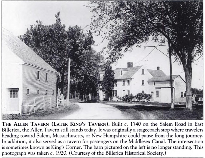 |
|
After Samuel’s death, his house and acreage were sold three times, in 1904, in 1911 and in 1913 before it was purchased in 1914, by Barnet M. Hein of Boston. Barnet was a land developer and quickly subdivided his recently purchased acreage into small lots, each averaging less than 3000 square feet. He hoped to capitalize on an anticipated local housing shortage resulting from the opening of the large Boston and Maine Railroad repair shop in North Billerica. The plan for the large subdivision was called King’s Corner and was advertised as being only a twelve-minute walk via the road from the railroad shops. It would be a fast-paced walk at best.
Although not typical, the lot including the tavern and outbuildings was much larger than others in the plot plan. In 1915, the 32,600 square foot lot with house and outbuildings was sold to members of the Currie Family. For the past one hundred eight years the house served as a private residence and more recently as a multi-family unit.
MISCELLANY
Back Issues - More than 50 years of back issues of Towpath Topics, together with an index to the content of all issues, are also available from our website http://middlesexcanal.org/towpath. These are an excellent resource for anyone who wishes to learn more about the canal and should be particularly useful for historic researchers.
Estate Planning - To those of you who are making your final arrangements, please remember the Middlesex Canal Association. Your help is vital to our future. Thank you for considering us.
Membership and Dues – There are two categories of membership: Proprietor (voting) and Member (non-voting). Annual dues for “Proprietor” are $25 and for “Member” just $15. Additional contributions are always welcome and gratefully accepted. If interested in becoming a “Proprietor” or a “Member” of the MCA, please mail membership checks to Neil Devins, 28 Burlington Avenue, Wilmington, MA 01887.
Museum & Reardon Room Rental - The facility is available at very reasonable rates for private affairs, and for non-profit organizations to hold meetings. The conference room holds up to 60 people and includes access to a kitchen and restrooms. For details and additional information please contact the museum at 978-670-2740.
Museum Shop - Looking for that perfect gift for a Middlesex Canal aficionado? Don’t forget to check out the inventory of canal related books, maps, and other items of general interest available at the museum shop. The store is open weekends from noon to 4:00pm except during holidays.
Web Site – The URL for the Middlesex Canal Association’s web site is www.middlesexcanal.org. Our webmaster, Robert Winters, keeps the site up to date. Events, articles and other information will sometimes appear there before it can get to you through Towpath Topics. Please check the site from time to time for new entries.
The first issue of the Middlesex Canal Association newsletter was published in October, 1963.
Originally named “Canal News”, the first issue featured a contest to name the newsletter. A year later, the newsletter was renamed “Towpath Topics.”
Towpath Topics is edited and published by Debra Fox, Alec Ingraham, and Robert Winters.
Corrections, contributions and ideas for future issues are always welcome.