
Middlesex Canal Association P.O. Box
333 Billerica, Massachusetts 01821
Volume 36, No.1 September, 1997
MIDDLESEX CANAL ASSOCIATION
TAKES TO THE BOATS!!
Exploring the Pawtucket Canal
Saturday, September 27, 9:30 am
Lowell National Historical Park Visitors Center
On Saturday, September 27, the Middlesex Canal Association will sponsor a boat ride on the Merrimack River and the Pawtucket Canal in Lowell, combined with historical background on this early waterway. The tour is presented in cooperation with the National Park Service, who will be supplying the boats.
This event, the fifth in the celebration of the Bicentennial Decade of the Middlesex Canal, will focus on this competing canal, built by entrepreneurs of Newburyport to connect their village with the resources of New Hampshire by bypassing the 30-foot high Pawtucket Falls. As a shipping and boat-building center, Newburyport, like Boston, needed access to the interior, principally for timber.
In 1792, a year before the launching of the Middlesex Canal, a Massachusetts corporation was formed that still exists today: The Proprietors of Locks and Canals on the Merrimack River. Its objective was to overcome restrictions to transportation on the river, such as falls and rapids. Their first venture, the Pawtucket Canal, was completed in 1796 and operated with marginal success for twenty years, after which it became the nucleus of Lowell's waterpower network. Dave Dettinger will describe the origins of this canal and its construction, along with additional commentary by Park Service rangers.
The event will begin at 9:30 a.m. at the Visitor Center Auditorium, with a trolley ride to the launch point. Reservations must be made in advance for the boat trip. A separate flyer will be mailed after Labor Day, including a reservation form and directions. All are welcome.
MIDDLESEX CANAL ASSOCIATION FALL WALK - 1997
A tentative date of Saturday, October 4, has been set for the annual fall walk of the Middlesex Canal Association. Additional details were not available at press time. A separate flier will be sent to members when plans become final.
PLANNING BEGINNING ON CANAL PARK
The Middlesex Canal Commission Chairman Tom Raphael has announced the selection of Icon Architecture as the consultants for planning the Canal Park to be located at the Concord River Mill Pond in North Billerica. The Plan will provide public access to the highest point on the Middlesex Canal. There are many proposed recreational activity and interpretive facilities under consideration.
Tom Raphael said that this is only the first phase of a multi-phase project, which may eventually link the whole Canal in a greenway park. There is good support among the public for such a project.
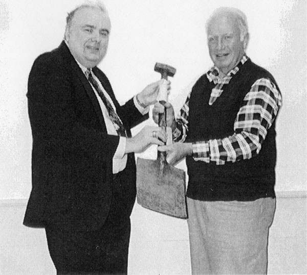
MCA President Nolan Jones presents one of the Middlesex Canal shovels to Lance Metz for
display at the National Canal Museum in Easton, Pennsylvania. (Photo by Joan Jones)
ANNUAL MEETING OF THE
MIDDLESEX CANAL ASSOCIATION
May 4, 1997
On May 4, 1997, members of the Middlesex Canal Association convened for their annual meeting in the Billerica Unitarian Church. Following the annual business meeting and election of officers, a program was presented by Lance Metz, Historian at the National Canal Museum in Easton, Pennsylvania. The talk was divided into two parts: a history of towpath canals in the United States, and an orientation to the National Canal Museum.
America was profoundly affected by the development of towpath canals. They were the origin of corporations in this country, since such organizations were needed to fund such large enterprises. The canal companies hired immigrants, since there were not enough local people to work; the immigrants usually stayed on when the work was completed. Towpath canals also represented the origin of civil and mechanical engineering in America. All this is represented in the Canal Museum.
Mr. Metz led the audience on a tour through the Canal Museum via slides and videotape. The Museum is on the upper floor of a building also housing the Museum and activity center for the company making Crayola crayons, and this was described briefly.
After Lance Metz's program, MCA President Nolan Jones presented one of the MCA's two remaining original shovels to the Canal Museum, as a loan to add to their display (see photo). Following this, the President called Burt and Fran VerPlanck to the front of the room. They were thanked for their many years of devoted service to the Middlesex Canal Association, and presented with a model of a canal boat as a reminder of the Association's gratitude. They were also made honorary directors. (See photo.)
Following the formal part of the meeting, the members enjoyed conversation and refreshments, including a canal boat cake in honor of the VerPlancks.
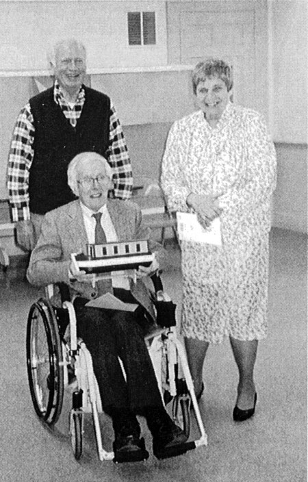
Burt and Fran Ver Planck, receiving a canal boat model in honor of their many years of devoted service to the
Middlesex Canal Association. Also shown is MCA President Nolan Jones. (Photo by Joan Jones)
MIDDLESEX CANAL SPRING WALK - 1997
by Bill Gerber
This spring we walked that section of the Middlesex Canal that passes through the Wilmington town forest. We assembled on Saturday, June 7, in the town recreation area parking lot along Route 38 and opposite the Continental Cablevision's offices, about 2½ miles north of Route 128. The actual trek began where Route 38 intersects the canal prism and proceeded north, passing the tow-line worn rock at the Ox-bow, crossing Maple Meadow Brook, traversing the road at Butter's Row and continuing on to Patch's Pond. From there we returned by the same route in reverse. The leaders consisted of Gerry and Betty Bigwood, Roger Hagopian, Carolyn Osterberg and Bill Gerber. The turnout was light, perhaps consisting of two dozen people. Prior to the appointed meeting time, to aid the Maple Meadow Brook crossing, a hand-line was rigged between several convenient trees to form a "railing" adjacent to a low log bridge that had been constructed by a local cub scout troop. This was much appreciated by several of the participants.
In years past, we have conducted the spring walk in late April or early May. This year, because of several external events that were scheduled to take place on June 7 (National Trails Day and a local historical celebration) we elected to conduct the canal walk on that same day. Now, many of us have become aware that every so often in life one does something that serves as a reminder as to why that something is normally done somewhere or sometime else. So it was with the early June canal walk. The mosquitoes were fierce! This reminded us all, of course, that we would be better advised to schedule the walk in late April or early May when there are no mosquitoes, as we have often done in years past. Ah! Will we remember this lesson the next time we schedule a walk in Wilmington?
SOME STRUCTURES IN THE MERRIMACK RIVER
by Bill Gerber
[Editor's note: the following was contributed last May, but should still be of interest to MCA members - Bill says there is a high level of speculation in his discussion.]
The water level behind the Pawtucket Falls Dam is currently down, probably by at least a foot, maybe more. This has exposed a spit of land at the upstream side of the river walk, along the Merrimack River in Lowell, that casual inspection suggests may have been a canal. The spit extends upstream as far as I can see. Downstream, it eventually disappears underneath the river walk; but it does so just upstream of the apparent remains of the entrance locks for the Middlesex Canal.
If these are canal remains, they may have once joined the Wickasee Lock, which (though I am not certain of the location of this lock) was probably located between the island now occupied by the Vesper Country Club and the north shore of the Merrimack River. If this speculation hangs together, the picture that I get is one of a canal that extended from the Wickasee Lock down to almost opposite the entrance to the Middlesex Canal. Traffic on the river could have left the downstream side of Wickasee under tow by a draft animal until nearly opposite the Middlesex, then ferried across the river to the canal, there to proceed into the locks of the Middlesex, or vice versa if transiting up the Middlesex Canal and the Merrimack River. (It is not clear to me that the spit would have extended down river as far as the entrance to the Pawtucket Canal, but that is also possible.)
As you probably know, in the first half of the 19th century, canal and river navigation existed all of the way between Charlestown, Massachusetts, and Concord, New Hampshire. From the north end of the Middlesex Canal, in Middlesex Village, it extended up to Concord through a total of 28 locks contained in a succession of seven Merrimack River canals. (Also, there were an additional eight locks in two canals that existed along the Merrimack between Newburyport and Concord.) The number of locks in several of the canals, including the Pawtucket, was reduced by the Union Canal Company during major consolidation and reconstruction that occurred, I think, about 1824. (A lot of this is written up in the Middlesex Canal Association's newest publication, Lewis Lawrence's manuscript.)
Also, from the river walk, just below the community boat house, looking across the river to the south shore of the Merrimack, a cupped "bulge" can be seen in the opposite bank. This appears to be just upstream of the auto storage yard, and so, I am guessing, it may once have been the backfill around the entrance lock to the Middlesex Canal (probably around the bottom lock). If so, then a bit more of the Middlesex has survived than I was previously aware of.
To view for yourself what I have been describing, I suggest that you find your way to Community Boat House on the north side of the river, park there, and walk
up under and beyond the Roark Bridge. All along your way, take a look at the debris-laden spit immediately below you, which continues upstream when the river wall turns out toward the street. Then walk down below the boat house, maybe 20 yards, find the auto storage yard, and look at the river bank just upstream of it. The cupped "bulge" can be seen very low above the level of the river.
APPLICATION FOR NATIONAL REGISTER UNDERWAY
A small "working group" has begun gathering information for the application for designation of the Middlesex Canal as a National Historic Site. The intention is to include all of the Canal in the new application. A previous designation included only some extant pieces of the Canal. The working group has been working with the Massachusetts Historical Commission, who will review and approve the final application.. The Middlesex Canal Commission is coordinating the town-by-town GIS mapping, which will eventually incorporate all the assessors' maps and owners of record for all properties within the Canal boundaries.
The first phase includes hiring a consultant historian to refine the historical data for the application. Gray Fitzsimmons of Lowell National Historic Park and Tom Mahlstedt of the Metropolitan District Commission have drafted a scope of work for this phase. MCA will act as the fiduciary agent for this. Tom Raphael, Chair of the MCC, is seeking funding sources to support this work.
Public meetings are a requirement of this process. Mike Wurm and David Malone of Lowell NHP are working with Bruce McHenry, secretary of MCA, to put together a public meeting. The Town of Billerica has been targeted for the first public meeting. This project will take about two years, it is estimated.
FINAL CANAL MARKER IN PLACE
In Billerica, on June 28, 1997, the ninth and final bronze plaque marking the Middlesex Canal was dedicated in a ceremony held by the Middlesex Canal Commission. The plaque is located next to the Canal at the High Street overpass. MCA board members, also Canal Commission members, Thomas Raphael and Carl Seaburg took part in the ceremony. In his invocation, Rev. Dr. Seaburg said:
We come together this morning to dedicate this monument to the work of our predecessors. It is fitting that we do this as once again we are about to celebrate America's birthday. For it was the release of energy with the birth of a new nation which inspired them to undertake this enterprise for the benefit of their new, their own country.
For fifty years the Middlesex Canal provided a vital link between Boston and the country, until improved modes of transportation replaced it.
But we should never forget the ingenuity of those people who envisioned this project. Nor forget their faith, their hope, their daring in undertaking it.
May we, their heirs and successors, not forget their remarkable accomplishment and their pioneering spirit. May that same spirit be in us. May it continue to inspire us to similar acts of daring and courage, of faith and hope, that will enrich this, our beloved country. Amen.
Shayne Reardon and Helen Knight, members of the Middlesex Canal Commission, unveiled the monument (see photo).
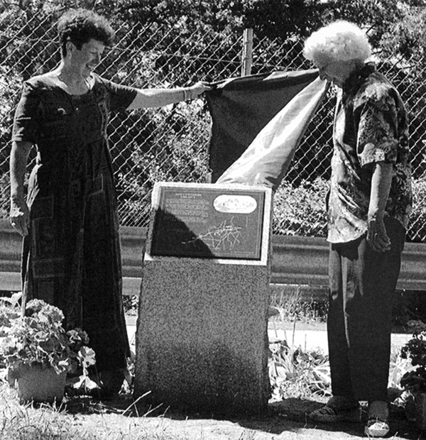
Unveiling of the Middlesex Canal monument in Billerica by Shayne Reardon (left) and Helen Knight,
members of the Middlesex Canal Commission. (Photo courtesy of Community Newspapers)
EXHIBIT GUIDELINES PUBLISHED
The Middlesex Canal Guidelines for Wayside Exhibits and Site Identification Signs was supported by a Greenways small grant two years ago. Originally Maryann Suttie, a graduate student and teacher was given the task of preparing the plan. Due to family health problems she was forced to give it up. Bruce McHenry of the Board of Directors of MCA volunteered to have his consulting firm, Team Interpretation, pick up the planning project. Bruce and Ray Price, a leader in this field, were given a detailed tour of the Canal by President Nolan Jones and Roger Hagopian.
The purpose of the project was to provide guidelines for the future development of wayside exhibits and identification signs along the Canal. The Plan was coordinated with the "Middlesex Canal Guide and Maps" by Burt VerPlanck. Sites identified for wayside exhibits all had public access and public parking, such as the Sandy Beach in Winchester or Wilmington Town Forest. Each wayside exhibit is described in the Plan.
Every road crossing with the Canal is targeted for an identification sign featuring a simplified logo. This would make the Guide more useful. The Plan also includes cost estimates. We hope the Middlesex Canal Commission is able to fund the next phase, Wayside Exhibit Design.
MIDDLESEX CANAL ASSOCIATION
OFFICERS AND DIRECTORS
1997-1998
| Nolan T. Jones, President 65 Summer St. Milford, NH 03055 |
Bettina Harrison, Vice-Pres. 19 Priscilla Lane Medford, MA 02155 |
Thomas Dahill, Vice Pres. 223 Broadway Arlington, MA 02174 |
| D. Bruce McHenry, Secy. 15 Chilton St. Belmont, MA 02178 |
Howard Winkler, Treasurer 10 Sleepy Hollow La. Arlington, MA 02174 |
William Drury, Mem. 24 Buckman Dr. Chelmsford, MA 01824 |
| David Fitch 15 Andover Rd. Billerica, MA 01821 |
David Barber 16 Ballou Rd. Hopedale, MA 01747 |
Betty Bigwood 300 Chestnut St. Wilmington, MA 01887 |
| Edith Choate 429 West St. Reading, MA 01867 |
Jean Potter 15 Pleasant View Rd. Arlington, MA 02174 |
Dave Dettinger 3 Penn Rd. Winchester, MA 01890 |
| William Gerber 16 Princess Ave. Chelmsford, MA 01863 |
Roger Hagopian 9 Cummings Ave. Lexington, MA 02173 |
Martha Hazen 15 Chilton St. Belmont, MA 02178 |
| Wilbar Hoxie 31 Green St. Reading, MA 01867 |
Thomas Raphael 90 Grove St. Winchester, MA 01890 |
Carl Seaburg 10 Rio Vista St. N. Billerica, MA 01862 |