
![]()
| Middlesex Canal Association P.O. Box 333, Billerica MA 01821 |
Volume 39 No. 1 |
CONTENTS:
Middlesex Canal Association Fall Walk
Fall Meeting - Extending the Middlesex Canal
President's Message - by Nolan Jones
The Faulkner Mills - by Alan Seaburg
Grand Opening of the Middlesex Canal Visitors Center
Two Weeks on the Canal Du Midi - by Martha L. Hazen
World Canals Conference 2000 - by Nolan Jones
The Middlesex Canal Seal Revisited: Translation of the Words on
the Banner
Locks and Canals of the Merrimack River - by Bill Gerber
MIDDLESEX CANAL ASSOCIATION
FALL WALK
Date: Saturday, October 14, 2000
Time: 1:30 pm
Place: Lowell branch from the Mill Pond in Billerica
Members and guests of the Middlesex Canal Association will join the Appalachian Mountain Club for a walk this fall, north of the Concord River Mill Pond in North Billerica. There will also be an opportunity for early arrvers to visit the new Middlesex Canal Visitors Center in the Faulkner Mill. Meet at 1:30 at the Mill Pond. Directions: Exit 29 from Route 3 (N of Rt. 128). At ramp end, take Route 129 toward Billerica. Turn right at Route 3A intersection, go about 0.1 mile. Turn left (at traffic light by a Mobil station) onto Treble Cove Road, go about 0.3 mile to a fork. Go straight and to the end of Wilson street. Turn right onto Old Elm Street and right again within about 100 feet into the Cambridge Tool Works parking lot.
Leaders: Roger Hagopian (781-861-7868) and Bill Gerber (978-251-4971)
FALL MEETING OF THE MIDDLESEX CANAL
ASSOCIATION
ON TO BOSTON: EXTENDING THE MIDDLESEX CANAL
Date: Sunday November 5, 2000
Time: 2:30 p.m.
Place: Hull Room, Boston National Historical Park, Charlestown
On Sunday afternoon, November 5, Dave Dettinger will present a talk describing the extension of the Middlesex Canal from its terminus in the Charlestown Millpond across the Charles River into the heart of Boston and the harbor. The meeting will take place at the Boston National Historical Park in Charlestown (formerly the Navy Yard) beginning at 2:30 p.m.
This presentation is the eighth in the series celebrating the Bicentennial Decade of the Middlesex Canal. In it, Dave will describe the background and layout of the four segments of the route: the Charlestown Millpond, the Charles River Crossing, the North Boston Millpond and its transformation into a canal to Haymarket, and finally the Mill Creek that reached the waterfront at Boston Harbor. Of this important waterway little evidence remains, save Canal Street, the one-time towpath through Boston.
Features of special interest include the design of an unusual cable system for hauling barges across the Charles River, locks capable of handling tidal rise and fall (bidirectional water flow), extended rock walls, and the exploitation of Mill Creek, which separated the North End from the Shawmut Peninsula itself.
Attendees may wish to explore other activities before and/or after the lecture. These might include boarding the USS Constitution and the destroyer escort USS Cassin Young, visiting the Constitution Museum and the Bunker Hill Pavilion where a video is shown, "Whites of Their Eyes," and touring Drydock No. 1, designed and built by Loammi Baldwin II during the 1830s.
Directions: Take Route 93 South to Exit 28, Sullivan Square and Charlestown. Stay to the left and go up the ramp and onto Rutherford Ave. You will pass Bunker Hill Community College on your right. Continue on Rutherford Ave. to the traffic light just before the Charlestown Bridge (Shell Gas Station is on the left). Turn left at the traffic light onto Chelsea Street. Continue to the next traffic light and take a right onto Warren and an immediate left onto Constitution Road. On the right will be the Bunker Hill Pavilion and the Visitor Center. Just past the bus loading area turn right and continue to the marked parking spaces near the USS Constitution. The meeting place is the handsome Hull Room, located on the second floor of Building No. 5 (no elevator), the building directly ahead of the Constitution’s prow. Enter by the north entrance.
PRESIDENT'S MESSAGE
21 September 2000
Many things are happening in our canal world. The biggest and best was the World Canal Conference in Rochester, NY, celebrating the 175th anniversary of the Erie Canal, described in a separate article.
The Billerica section of the Middlesex Canal Commission put in herculean efforts and opened the Visitors' Center on September 16 and 17 for the Billerica Yankee Doodle days. There was a steady stream of visitors to the Center. The Billerica section should be commended for their effort.
The fall walk is noted on the front page of this Towpath Topics. I have arranged for the Visitors' Center to be open at the beginning of the walk, so come early and take in the Center.
The PAL work was completed a year ago. The recommendation was that we need to establish the exact location of the canal in several areas by means of research into the deeds of the properties. We are preparing a statement of work to do that. If anyone is interested in doing that please let us know.
About 20 years ago we had a few excursions to other places of interest to Canalers. There are several places that could be one-day trips, such as the Cumberland and Oxford canal near Portland, ME, and numerous others that could be an overnight or weekend trip, like the Delaware and Hudson Canal in New Paltz, NY. If you are interested in such excursions please let me know.
Nolan T Jones, President
THE FAULKNER MILLS
by Alan Seaburg
Faulkner Mills is adjacent to the Concord River’s milldam at North Billerica. The area was originally meadow land and its hay and grass were used by the early English settlers as food for their farm animals. As it was subject to annual floods, attempts were made to curtail the problem. In 1659 William Sheldon received permission to construct a mill to grind corn, but it was not until 1708 that Christopher Osgood successfully erected an effective dam here. All future owners of this spot trace their deed to Osgood and his dam. By the end of the 18th century there were five grist mills, three saw mills and one fulling mill at work here.
During the period of the Middlesex Canal’s operations, its Proprietors were in charge of the area and continued to run the mills as well as a fishway. For them, Loammi Baldwin replaced Osgood’s old worn dam with a new one near the current dam at Faulkner Street bridge. In 1828 the Proprietors again built a new dam on this site. At the Canal’s demise, the control of the area passed to two families: the Faulkners and the Talbots.
Francis Faulkner had run a textile mill in North Billerica since 1811. He began with a fulling mill but eventually had several other buildings. Unfortunately, these were destroyed in 1818 by fire. Undaunted, Faulkner rebuilt his business and in 1825 purchased in England new looms run by water power. By now, his son James Robbins Faulkner had joined his father’s business. Additional land and buildings were added to their original holdings, and the firm went from manufacturing cloth to flannel. A steam boiler was added in 1834. Two years later a second fire destroyed much of the property.
As a result, the three-story brick factory familiar today was constructed, with its Georgian-style cupola; a four story brick edifice which became the Mill’s main building was added during the Civil War. The business prospered: in the late 1870s it provided work for 70 men and women. This staff included several young girls, and so James’s three daughters established for their education the Faulkner Kindergarten. About the time of the First World War, the company was re-organized as the North Billerica Company. It had a staff of 135, who produced wool blankets and various colored cloth. In spite of the changing economic conditions that now began to affect New England’s mill business, the company remained in operation until the 1980s. For some time after the plant closed, the structures remained vacant, until their current rebirth.
GRAND OPENING OF THE
MIDDLESEX CANAL VISITORS CENTER
The new Middlesex Canal Visitor Center in the restored Faulkner Mills in North Billerica opened Saturday, September 16, and Sunday, September 17, 2000, during Billerica’s Yankee Doodle Days celebration. The great amount of work invested in restoring the old textile mill was evident everywhere. The walls, floor, and ceiling all had been cleaned by a dedicated group of people from the Billerica Section of the Middlesex Canal Commission. Leading the group was John Reardon, who devoted much hard work and organization to the restoration. Many others donated time, talent, and money to the project. Grants from Welch’s Grape Juice and the Greater Lowell Foundation also helped and are acknowledged with thanks.
Tom Dahill, a member of the Exhibit Planning Team designed and set up the current temporary exhibit, which features the drawings and paintings he made for the book The Incredible Ditch. The exhibit also includes copies of early documents pertaining to the Canal, models of a canal boat and the Shawsheen Aqueduct, and one of the original shovels used in the construction of the Canal. There are also short videos available for viewing. The temporary exhibit will serve as a guideline for the permanent exhibits to be installed later.
The Middlesex Canal Association is a partner with the Billerica Section of the Middlesex Canal Commission in supporting the Visitors Center. The opening was well attended, and refreshments were provided by members of the Billerica Section. Members of the MCA helped to staff the Center for the event.
The Visitors Center is currently open by request only. Call John Reardon at 978-667-1787.
TWO WEEKS ON THE CANAL DU MIDI
by Martha L. Hazen
On Sunday, May 21, 2000, at the Annual Meeting of the Middlesex Canal Association, Martha Hazen and Bruce McHenry gave a slide talk on their trip the year before by rental barge on the Canal du Midi. On this trip they were accompanied by Martha’s brother Nate Hazen and his wife Roddy.
In the mid-17th century, Paul Riquet presented to the French finance minister his proposal to build a "Canal de Communication des Deux Mers," or a canal connecting the Mediterranean Sea with the Atlantic Ocean, north of the Pyrenees, and thus bypassing the Iberian Peninsula. This canal comprises an eastern and a western half; the latter is known as the Canal latéral á la Garonne (that is, parallel to the Garonne River which reaches the Atlantic at Bordeaux, and the former is the Canal du Midi.
We flew to Marseille via Paris, and took a train to Montpellier, near the coast of the Mediterranean. Nearby we picked up our barge from Locaboat, the outfitter. Designed to sleep a maximum of seven, it was very comfortable for the four of us. There were two sleeping areas with double beds, with the head, sink and shower in between, a raised wheelhouse, and a well-equipped galley and dining area.
A short distance down a feeder canal put us in the Canal du Rhône à Sète, which went through several Étangs, or sections of the Sea divided from the main Mediterranean by barrier beaches. The last one of these, the Étang de Thau was large and lined on the north side with miles of oyster beds. From this, we entered the Canal du Midi, and suddenly we were greeted with the sight that accompanied us all along. Huge plane trees, planted at regular intervals, lined the Canal on both sides, giving a wonderful green shade. And yellow flags (iris) were frequent along the water line.
Our second night was spent outside of Agde, where the Canal du Midi joins with the Hérault River for a short distance. The river leaves the Canal to go over a dam, and the Canal feeds into a unique round lock with three gates: one to enter from the Canal, one to leave on the Canal, and the third used to lower boats to the lower level of the River. The second gate for the Canal actually has two sets of gates, one pointed in each direction. In Agde, we had our only misfortune. While we were in town picking up supplies, someone broke into our boat and relieved us of several things, making a bit of a mess in the process. They stole two (matching) suitcases, a couple of jackets, a pair of trousers, and a few small things; unfortunately they also stole Bruce’s back pack, which had his passport in it. The net result was having to buy two new suitcases in the largest town we went through - Carcassonne - and having to return to Marseille one day early to obtain a replacement passport. Both turned out to be quite easy.
Two days later, we passed through one of the most interesting features on the trip - the staircase of locks at Fonserannes, near Béziers. Today, only six of the locks are necessary, although they originally numbered eight. Originally, the Canal joined the River Orb before Fonserannes, and was lifted up out of this by a lock no longer in use. Instead the Canal remains higher than the River and crosses it on a beautiful aqueduct. The staircase is run in an upward direction for a couple of hours, and then in a downward direction. We entered the round lock (the seventh, and currently not used as a lock) at the bottom just after lunch. We were not prepared for the way the éclusiers (locktenders) ran the lock; when the gate was shut behind us, the next gate was open and we were greeted with a gigantic waterfall heading in our direction. We held on tight to our ropes, until we were told to move forward into the second lock, and the gates again closed behind us. Another two times we were greeted by torrents, as we passed through the remaining four locks. We were now far above the Orb valley.
The Canal du Midi then began its meandering. To avoid ups and downs as much as possible, the canal follows the contour of the land in this hilly area. On the left, we looked out below us over vast acres of vineyards - this area is, of course, one of the big wine-producing areas of France. And on the right were pastures sometimes, or more wine trellises, mostly above us. We tied up in small towns near other boats (the experience at Agde was not repeated), and often walked to town for exercise and to pick up bread, wine, local patés, and local cheeses. At one town we were able to tour the winery and sample the wines. Not far from that, we were able to see the snow-covered Pyrenees in the distance. From time to time, we crossed rivers on ancient aqueducts, many dating from the 17th century. And there were always locks, sometimes two, three, or four at a time.
After a week, we stopped in at the Locaboat base at Argens-Minervois to have some servicing done, and get clean linens. Then we were on our way for the second week of winding and twisting through the spectacular countryside. We happened to be in one small town for its market day, and picked up some delicious fish, as well as a raincoat for my brother to replace the stolen one.
Midway through the second week we tied up in Carcassonne, the heavily restored old city with its impressive citadel. We toured this in the pouring rain; there were not many tourists around that day. For a remarkably low price, we picked up two suitcases to replace the ones stolen so we could get our clothes home.
Two afternoons later, we negotiated a four-lock staircase going into Castelnaudry in a violent rainstorm with large hail. The éclusier, in his windowed tower overseeing all four locks, didn’t seem to notice the weather, so we pressed on, with the now-familiar torrent of water greeting us in the locks. The following day, we reached the summit level of the Canal du Midi. Here, the builder Riquet captured numerous small streams into one large reservoir to feed the Canal. The reservoir itself was too far to walk, but we saw the feeder canal as well as the obelisk built to honor Riquet.
That night we spent in Villefranche. Bruce and I had to leave the next morning for Marseille to negotiate his passport, while Nate and Roddy took the barge on to the little town of Negra, where Locaboat has its terminus at the éclusier’s house.
We did have the extra day in Marseille, and found it a spectacular and very interesting city. The U.S. Consulate made it very easy for us to get the needed passport, so we had a lot of time to poke around. (Note that having a photocopy of the pertinent page of the passport separate from it made getting the new one much simpler - in by 11a.m., out by 3p.m.) Nate and Roddy joined us the next day for a last tour of Marseille before going home. We left Marseille on a crystal clear Sunday morning, with gorgeous views of the Alps on the way to Paris.
WORLD CANALS CONFERENCE 2000
by Nolan Jones
The World Canals Conference 2000 in Rochester, NY, also celebrated the 175th anniversary of the opening of the Erie Canal. The Canal Society of New York and the New York State Canal Corporation were the co-sponsors. There were several major corporate supporters that produced a grand and gala conference. There were 425 attendees.
The present Erie canal flows east and west about one mile south of the center of Rochester and crosses the Genesee River at water level. The Genesee flows north into the center of Rochester. The conference started on Sunday, September 10, the "Public Celebration Day". A flotilla of 75 boats paraded from the Erie Canal up the Genesee River into the new Corn Hill dock/park area where they were greeted by four high school/college bands, fire boats, and thousands of spectators.
The following five days were filled with papers, receptions, excursions, field trips, meetings and meals. There was a laser show in the "Genesee Gorge" that was quite spectacular. We enjoyed four boat rides. The governor opened the conference at the first luncheon. Other dignitaries included the county executive, the mayor, the senator and other politicians.
One item of some interest to our community is that the Deleware and Hudson Canal Historical Society is sponsoring a play entitled "Tales of the Middlesex Canal", to be presented on Sunday, November 5th, in High Salls, NY. My first reaction was to propose that some of us attend the play but it is the same day as our fall program. I suggested that they send us a copy of the script in the interest of accuracy.
The mechanism for setting future world canal conference dates is still unresolved. The Inland Waterways International (IWI) has proposed an eleven member international committee and the American Canal Society (ACS) has agreed to that for two years. Since the World Canals Conferences have become so elaborate and expensive to produce the ACS is considering an alternative to WCCs, namely regional inter-canal conferences in the USA when the WCC is scheduled in Europe. The present schedule has WCCs on alternating sides of the Atlantic. Last year the conference was in France/Belgium. This year in the USA. Next year it will be in Ireland. The following year in Ontario, etc.
Eight members of the MCA attended - Tom and Elva Raphael, Arthur Sweeton and his wife, Joan and me, Bill Gerber and Karen Hull.
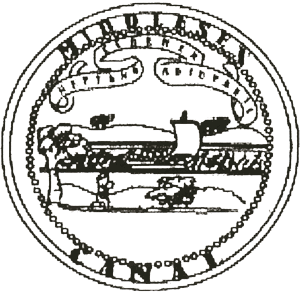
THE MIDDLESEX CANAL SEAL REVISITED:
TRANSLATION OF THE WORDS ON THE BANNER
In the March issue of Towpath Topics, there was an article about the Middlesex Canal seal. At the top of the seal there is a decorative banner bearing the words
CEREREM NEPTUNO ADJUVANTE
According to the Department of Ancient and Modern Languages at Arlington High School the English translation is
Neptune, The God of the Sea Helping Ceres, the Goddess of Grain
[Editor’s note: We reproduce the seal again below; the description of the seal appears in the March 2000 issue of Towpath Topics, on p. 8.]
LOCKS AND CANALS OF THE MERRIMACK
RIVER
by Bill Gerber
[Editor’s note: this interesting piece of research by Bill Gerber produced a document that is too long for a single issue of Towpath Topics, so the first half is presented here. More discussion of shipping and a description of the archaeological remains, as well as the bibliography, will appear in the next issue.]
Caveat: The information in the paper to follow has been generated, for the most part, from secondary sources. However, there are enough disagreements among sources to suggest that a more comprehensive study of both the Merrimack River and the Middlesex Canals, together, using primary source materials, could result in significant changes to the findings presented below.
Introduction
In 1847, the Providence and Worcester Railroad opened in competition with
the Blackstone Canal. Business quickly migrated to the railroad and that canal
ceased commercial operation in November of the following year. This was perhaps
an extreme example, but not atypical, of the fate that confronted most of our
historic canals.
The Middlesex Canal fared somewhat better in the face of railroad competition. The Boston and Lowell Railroad began operations in 1836, and the canal continued to operate. The railroad reached Manchester in 1842, and still the canal persisted. It was not until it reached Concord, NH, in 1848, that the railroad was able to deliver a mortal blow to the Middlesex Canal. Even then, the canal struggled along for another few years, logging its last toll in 1851 but continuing to serve a dwindling customer base for a few years beyond that date. [NB. Other sources indicate that the railroads came earlier, apparently between Nashua and Concord by 1842, and the canal competed successfully for a longer period of time than originally believed.]
Background
There appear to be several reasons for the Middlesex’s tenacity. Foremost,
the Middlesex was only part of a much more extensive transportation system.
North of the Middlesex Village (now part of Lowell) end of the Middlesex Canal,
there were another eleven canals, encompassing as many as 23 locks (the number
varied over time), which formed a transportation corridor extending between
Boston, MA, and the areas well above Concord, NH.
Second, there was a diversity of shippers who used the canal and a wide range of goods that were shipped on it. For example, about a third of all the goods carried into eastern Vermont and western New Hampshire came by canal and river, as did a much larger share of the goods seeking the seaboard. A very substantial factor was the existence of many private shippers who operated on the canal, in much the same way as free-lance truckers ply the highways today. That the principal shipping company established an effective infrastructure to support their operations and eventually became quite efficient in the way they conducted their operations may also have contributed, but appears not to have been a factor for very long.
There may have been another contributor. Little mention is made of the competition for water between the mills and the canals that caused significant conflict elsewhere. Yet, any water used to operate the locks at Amoskeag, owned by the Proprietors of the Middlesex Canal, was then not available to turn the wheels of industry in the Manchester Mills. However slightly, this improved the competitive position of the Lowell Mills. En route, there was no significant competition for the water used by the Union Canals. But water through the locks of the Middlesex Canal added slightly to that available to power the mills in Lowell. This was probably not a factor of great significance but may have contributed in some small way.
The Merrimack River Canals
After the Middlesex Canal was opened for travel, in 1803, attention turned
to making the Merrimack River navigable for canal boats. Many obstacles had to
be overcome to accomplish this. From Concord NH to Chelmsford MA, the river fell
a vertical distance of about 135 feet in 12 waterfalls and difficult rapids.
Traveling up the river, from the head of the Middlesex Canal, the first
obstruction encountered was Wicasee Falls at Tyngsborough, where the river fell
3 feet in about a third of a mile. Fifteen miles further up was Cromwell’s
Falls with a 6 foot drop in a little less that three-quarters of a mile. In the
nine miles upstream of the town of Merrimack, itself four miles above Cromwell’s
Falls, there were a total of six falls, as follows: Moor’s Falls, with a fall
of 6 feet in about 650 feet; Coos (Cohas) Falls, 3 feet in 500 feet; Goff’s
Falls, 6 feet in about 1100 feet; Shorts, 7 feet in about 30 feet; Griffin’s,
drop not stated; and Merrill’s Falls, 3 feet in about 160 feet. Half a mile
above Merrill’s Falls was Amoskeag Falls at Derryfield (now Manchester). Here
in a series of three falls the river fell 54 feet in half a mile. The river was
then clear upstream for about 8 miles to Hookset Falls, where there was a drop
of 16 feet in about 800 feet. Seven miles beyond was Garvin’s Falls, with a
drop of 25 feet; and one mile beyond Garvin’s there was a 5 foot drop at
Turkey Falls. There were still additional falls north of Concord, but the
railroads came along before these could be effectively conquered.
Over the period from 1809 to 1817, canals and locks would be built at all of these except the last; this would be rendered unnecessary by raising the water level behind a dam at Garvin’s Falls high enough to flood Turkey Falls. Each of these canals is briefly described below.
Wicasee Falls Canal - In February 1813, following authorization by the Massachusetts Legislature, the Proprietors of the Middlesex Canal initiated work on the Wicasee canal. It consisted of building a 600 foot stone and timber dam across the rapid from Wicasee Island west to the opposite shore of the river, and a lock, probably 10 x 82 feet, between the island and the east shore, about 1900 feet in from the north end of the island. This was accomplished by or before 1815, at a cost of $12,000 to $14,000. A lock-tender’s house was added by 1817. The lock and the dam at Wicasee were short-lived. In 1824, the Pawtucket Dam was built, which raised the water level to a new height, about 5 feet higher, such that it flooded the Wicasee structures. Subsequently, the lock was abandoned and the dam was breached to allow passage of boats on the 18-mile slack-water lake created behind the Pawtucket Dam.
Cromwell’s Falls Canal - On December 17, 1812, the New Hampshire Legislature authorized the Proprietors of the Locks at Cromwell Falls to build locks and wing dams on the westerly side of the river. A single lock, similar to the one at Wicasee, was built along with a 2000-foot dam that extended to the head of the rapid. This effort appears to have completed by 1815 and cost about $9000. The Legislature also authorized the transfer of the rights and privileges of this endeavor to the Union Locks and Canal, as an addition to their charter, which was done in August of the following year.
Taylor’s and Hill’s Falls - Unspecified work (possibly the construction of boat chutes) was done at these two sites in 1812, in conjunction with improvements to the Wicasee and Cromwell’s Canals, to improve navigation through or around them. The total expense for all of these efforts was $158.78.
Moor’s Falls Canal - Construction of this and the next five canals was undertaken by the Union Locks and Canal Company. Jonathan and Ebenezer Eastman, Isaac Chandler, and Winthrop Fifield were incorporated as the Proprietors of the Union Locks and Canal(s) by the New Hampshire Legislature in December of 1808. They were empowered to clear the Merrimack River from Reed’s Ferry to Amoskeag Falls and to construct the necessary locks and dams. The effort at Moor’s Falls consisted of constructing two 10 x 82 feet drop-gate locks in a towpath canal about 2000 feet in length at the foot of the falls, and a dam about 3200 feet long. In addition to stock shares, lotteries were authorized by the New Hampshire and Massachusetts Legislatures to help raise money to fund construction. By 1811, the Middlesex Canal Company had acquired a three-quarters interest, such that they effectively controlled the Union Locks and Canal Company. The work was completed by 1813, at a cost of about $15,000.
Coos (Cohas) Falls Canal - The second of the six Union Canal Company endeavors, the effort at Coos consisted of a single 10 x 82 foot drop-gate lock in a short towpath canal on the east side of the river and a dam of about 2500 feet in length. This work was completed by 1811 at a cost of about $5,000.
Goff’s Falls Canal - Another Union Canal Company endeavor, the effort at Goff’s consisted of the construction of a single 10 x 82 foot drop-gate lock in a short towpath canal on the west side of the river, and a dam of about 2500 feet in length. This work was completed in 1811 at a cost of about $7,000.
Griffin’s Falls Canal - The fourth of six Union Canal Company endeavors, the effort at Griffin’s consisted of the construction of a single 10 x 82 foot drop-gate lock in a short towpath canal on the east side of the river, and a dam of about 2500 feet in length. This work was completed in about 1813 at a cost of about $4000.
Short’s Falls Canal - Also a Union Canal Company endeavor, the effort at Short’s consisted of the construction of a single 10 x 82 foot drop-gate lock in a short towpath canal on the east side of the river, and a dam of about 2500 feet in length. This work was completed in about 1813 at a cost of about $6,000.
Merrill’s Falls Canal - This was the sixth of the six Union Canal Company endeavors. The effort at Merrill’s consisted of the construction of a towpath canal about 1600 feet long with a single 10 x 82 foot drop-gate lock, on the east side of the river, and a dam about 2500 feet in length. This work was completed in about 1813 at a cost of about $10,000.
Blodget’s/Amoskeag Canal at Amoskeag Falls - Construction of Blodget’s Canal at Derryfield (now Manchester) NH was begun by Judge Samuel Blodget following authorization by the New Hampshire Legislature in December 1798. This effort ran into extensive financial difficulties and, on several occasions, the legislatures of both New Hampshire and Massachusetts authorized lotteries to raise the money to continue the work. The canal initially opened in 1809 with 9 locks, apparently 11 x 100 feet, in a channel that ran in the river below the falls and extended for more than a mile and a third. The canal was partially rebuilt and fully repaired in 1812; and then was renamed the Amoskeag Canal in 1815 and rebuilt the following year. At that time, it appears that a new channel may have been cut into the eastern bank and the number of locks was probably reduced from nine to seven. As they did with the Union Canal, the Proprietors of the Middlesex Canal acquired a controlling interest in the Amoskeag Canal by or before 1817. The Amoskeag Canal Company acquired the canal in 1835.
Hookset Falls Canal - Robert McGregor and William Duncan were incorporated as the Proprietors of the Isle of Hookset Canal in February 1794. The Middlesex Canal Company began to invest in this endeavor as early as 1810 and thereafter had provided such extensive support that by 1811 they effectively held controlling interest. Construction consisted of a 1300 foot long canal containing a guard-lock and two 10 x 82 foot lift locks, and a 250 foot dam. This effort was completed in 1811 at a cost of $13,000.
Bow Canal at Garvin’s Falls - This consisted of a 1900 foot long canal containing a guard-lock and three 10 x 90 foot lift locks, and a 450 foot dam across the river at the head of the falls. The canal was authorized in June 1808 and completed by 1812 at a cost of about $19,000.
Nashua and Piscataquog River Canals - These are suggestions that canals may have been built, early on, near the junction of these rivers with the Merrimack, to provide access to the respective villages. But, at the time of writing of this paper, the only known effort was begun by the Nashua Manufacturing Company in 1824, under the supervision of Colonel Baldwin, and completed in 1826 at a cost of $30,000. This included the building of a canal with four stone locks and a dam at Mine falls on the Nashua River.
Operation of the Canals
On the average, the canals were open for business for a full eight months of
each year. It took nine days to make the round trip between Boston and Concord
NH; five days up and four returning. This remained the average for twenty years.
Shipping charges were set to reflect the longer time and greater expenditure of
labor required to ascend the canals and river.
Boat sizes ranging from 45 to 75 feet in length and from 9 to 9.5 feet in width were permitted to operate; most of the boats were of the larger size. The higher limits held likewise for rafts, of which as many as ten were frequently fastened in tandem. Normally, these were separated only when transiting the locks.
Speed of travel on the canals was regulated. Passenger boats were permitted to travel at four miles per hour; cargo craft could travel at 2½ miles per hour. On the towpath canals, except when locking through, manpower was not permitted to draw the boats; this function was relegated to the use of oxen or horses. On the river, multiple forms of propulsion were employed. These included scull oars, poles tipped with iron, and sails.
Locking after dark was forbidden. Dark was defined as after 7 p.m. in the spring and fall, or after 9 p.m. in the summer, except during the moonlit nights when lock-tenders stayed on duty until 10 p.m. Travel on Sunday was permitted; however no horns were permitted to be sounded to disturb the worshipers.
At the time of their incorporation, the canal companies were authorized by the legislatures of the respective states to hold a limited amount of property and to collect tolls. Typically, the schedule of tolls was described as part of the legislation. A simple example, "... for every ton of Oak timber and logs that passes through said canal [the toll] shall be thirty-two cents; for every ton of pine timber, sixteen cents; for every ton of pine logs, ten cents; for masts, sixteen cents for each ton; and no more anything in any former act to the contrary notwithstanding."
Shipping
There were a number of private boats that regularly operated on the
Merrimack River and Middlesex Canals. Private carriers, known in those days as
"transients," usually carried the bulk of the freight to Boston. One
source indicates that about fifty of these transient boats were employed during
a busy season; another puts the figure between 200 and 250. In either case, it
was observed that their operation was often casual in nature, with the boatmen
interrupting their service to tend to essential agricultural duties at certain
times of year. In terms of reliability, it is said that they occupied a position
between "irregular and uncertain," on the one hand, and that of the
Merrimack Boating Company, which ran freight boats through on a regular schedule
between Concord NH and Boston, on the other. However "irregular and
uncertain" they may have been, there are indications that they captured
most of the non-through shipping business well before the canals closed in the
mid-1800s.
By the late 1820s, at least one private boating company had been established, by the Hamilton Mills, the sole purpose of which was to transport manufactured goods from the textile mill to market, and return with raw materials and other related items. But the historic descriptions of boats engaged in commerce suggest that this was not the only private company that operated on the canals.
Several companies were organized to operate commercial boats on the Merrimack River and the Middlesex Canal. The principal ones were the Merrimack Boating Company, 1811-1823, which was closely allied with the proprietors of the canal; its successor was the Boston and Concord Boating Company, 1823-1842. The Union Boating Company, 1820-1821, was briefly a rival of the Merrimack Company.
In 1809, in a report to the proprietors of the Middlesex Canal, John L. Sullivan (soon to be the agent for the Merrimack Boating Company) stated: "Our own boats not going further than to the head of the Canal, transportation on the River has been left up to private enterprise. A number of boats constantly ply from Boston as far up as the town of Merrimack, twenty three miles from the head of the Canal and seven miles short of the Amoskeag Canal."
The following year, Sullivan noted: "... boating up river has been attended ... in fixing the landing places at Tyngsboro and Nashawa with proper machinery to unload, and in assisting the neighborhood to erect stores ... for the reception of goods." As soon as this was done, two boats went regularly, twice a week, from the Boston landing to those places. On another occasion, Sullivan stated: "As early as 1810, I commenced on my own account and risk, the transportation of goods by water as far as the state of the river would allow. And previously to its being fully opened to Concord, erected warehouses there and at other places where the principal roads diverge from the river into the country."
(To be concluded in the next issue)
NOTE FROM THE EDITOR
Your editor would be delighted to receive comments about this newsletter at any time. Also, submissions are very welcome. She can be reached by email (removed) or by snail mail: Martha Hazen, 15 Chilton Street, Belmont, MA 02478 (Note: Martha has since passed away.)