
![]()
| Middlesex Canal Association P.O. Box 333, Billerica MA 01821 |
Volume 42 No. 1 September 2003 |
Contents:
MIDDLESEX CANAL ASSOCIATION FALL WALK
FALL MEETING OF THE MIDDLESEX CANAL ASSOCIATION
EDITORS NOTE by Martha Hazen
THE SPRING CANAL WALK 2003 by Bill Gerber
FOR 300 YEARS, TWO NEIGHBORS HAVE BEEN TAKEN FOR GRANITE by Libbie Payne
SPRING MEETING 2003 by Roger Hagopian
CROSSING THE CONCORD RIVER THE MIDDLESEX CANALS FLOATING TOWPATH by Bill Gerber
COST TO BUILD THE MIDDLESEX CANAL IN THE 21st CENTURY by Howard Winkler
MIDDLESEX CANAL ASSOCIATION FALL WALK
Date: Saturday, October 18, 2003
Time: 1:30pm
Place: Woburn
Our fall walk will include two watered sections of the Middlesex Canal in Woburn. We will meet at 1:30 pm at the parking lot behind the Woburn Cinemas on Middlesex Canal Drive, off Route 38 just south of its intersection with Route 128 (Interstate 95) at Exit 35.
The walk will be conducted in two segments. The first will proceed south along the watered canal from the parking lot to Winn Street and return. After returning to our cars, we will drive to park again for the second segment, north of Route 128.
Leaving the Cinemas parking lot on Middlesex Canal Drive, take a left back onto Route 38 heading north. After passing under Route 128 (95), take a right turn at the lights onto Alfred Street to the Baldwin mansion, a few hundred feet on the left. The second segment of the walk will proceed north from the parking lot behind the mansion, most recently known as Baldwins Landing Restaurant.
For more information please call (no later than 10pm) Bill Gerber 978-251-4971 or Roger Hagopian 781-861-7868.
FALL MEETING OF THE MIDDLESEX CANAL ASSOCIATION
THE CAPE COD CANAL: A HISTORY
Date: Sunday, November 2, 2003
Time: 2:30pm
Place: Middlesex Canal Museum & Visitor Center, 71 Faulkner Street, North Billerica
Speaker: Col. Wilbar Hoxie, U.S. Army Corps of Engineers, retired
Wil, a long time member, Board member, and former President of the Middlesex Canal Association, grew up on Cape Cod and has a connection with the Cape Cod Canal dating back to his youth. He will outline the Canals history and share his personal insights with us.
Directions: From Route 3, take exit 28, Treble Cove Road. Turn towards North Billerica. At about ¾ mile bear left at a fork. After about another ¾ mile, cross Route 28 at a traffic light. Go about ¼ mile to a 3-way fork; take the middle road, which will put St. Andrews Church on your left. Go about ¼ mile; bear right, then turn right onto Faulkner Street. Go about ¼ mile. The Museum & Visitor Center is on your left, and you can park across the street on your right, just beyond the falls.
The annual Canal Heritage Days celebration with the Lowell National Heritage Park (LNHP) will be held on the Columbus Day weekend, October 10-13. The American Canal Society will be meeting with us also. It promises to be a busy and interesting weekend. This will be an opportunity to meet canawlers from other areas and compare notes on their work on their canals. (See fuller schedule elsewhere in this issue.)
The exhibits in our museum have been "refreshed" by new exhibits of the New Hampshire canals along the Merrimack River, extending our Middlesex Canal "waterway" up to Concord. Bill Gerber pulled together that display. Dave Dettinger prepared an exhibit of the extension of the Middlesex into Boston as a new exhibit. If you have toured the museum in the past you should go back again for the new material. The merchandise area has been upgraded with new display cases and counters. There is a model village in one corner for the entertainment and education of young visitors. We continue to need more docents.
Recent speaking engagements have included Medford library and retired Boston & Maine employees. On September 8, I gave a talk to a group of seniors in North Reading.
Nolan T. Jones, President
(603) 672-7051
2003 CANAL HERITAGE DAYS
Celebrating the 200th Anniversary of the Middlesex Canal and 25 years of Lowell National Historical Park.
Join us as we celebrate over 200 years of canal history in the Merrimack Valley, the 200th Anniversary of the completion of the Middlesex Canal, and the 25th Anniversary of the establishment of Lowell National Historical Park. Over the Columbus Day weekend you can participate in special presentations, hands-on activities, tours, and exhibits all commemorating Americas canal heritage.
The weekend of events begins with free daytime programs, an evening reception at the American Textile History Museum, and keynote address on Friday, October 10 by Nolan Jones, President of the Middlesex Canal Association and Tom Raphael, Chairman of the Middlesex Canal Commission.
On Saturday, October 11, Lowell National Historical Park, Tsongas Industrial History Center, and American Textile History Museum will host a variety of free programs and activities for all ages.
Sunday, October 12, the Middlesex Canal Museum-Visitor Center in the Faulkner Mills in North Billerica will host activities from 10:00-4:30pm. Storytelling, lectures by Middlesex Canal Museum and Commission staff, boat rides on the Concord River (if water level and weather permit) and family activities will be offered free of charge throughout the day. Alec Ingraham will narrate a 1½ mile walking tour of the historic Mill Village (1:00-2:00), beginning at the red locks, right next to the North Billerica Fire Station. A catered lunch will be available at a nominal charge. At 1:30, transportation planner and volunteer guide Bill Kuttner will offer a ten-mile guided bike tour of the remnants of the Middlesex Canal beginning at Lowell National Historical Park Visitor Center and finishing at the museum and historic Mill Village in North Billerica at about 4:00pm.
On Monday, October 13, American Canal Society Vice-President Bill Gerber will lead a car tour of the canals of the Merrimack River
For more detailed information call (978) 970-5000 or check the website: http://www.nps.gov/lowe
For 16 years, I have been editing, producing, and mailing Towpath Topics. The interval has seen the transition from paste-ups to be photocopied to complete electronic production and addressing. I have received invaluable help from Kwik Kopy in Arlington Center during recent years, and thank them for this. Beginning with the Spring 2004 issue, the MCA webmaster, Robert Winters, will assume the responsibility of the newsletter. He can be reached through our website: www.middlesexcanal.org. My very warm thanks go to all who have helped me over the years; I have thoroughly enjoyed my term as editor, and wish Robert every success in his.
THE SPRING CANAL WALK 2003
by Bill Gerber
Normally, I enjoy introducing people to a little known era of American History, in general, and, more specifically, to a significant piece of local heritage. But every so often a walk is scheduled where, as a walk leader, I truly hope that no one will show up. Alas, Spring 2003 was one of those times.
Our Spring event was, as usual, a joint endeavor with the Appalachian Mountain Club. We planned to walk part of the Lowell section of the Middlesex Canal, from the Mill Pond in North Billerica to Riverneck Road in Chelmsford. Normally this is a delightful section of the old canal. It proceeds in a nearly straight line along roads, through wooded areas, and across a swampy area. Both the towpath and the canal are readily recognizable for most of the way, and pauses can be made to show off the anchor stone for the floating towpath (on the western shore of the Concord River), the entrance gate segment of the western Guard Lock (within the iron fence by Talbot Mill), and the remains of Oak Lock together with its turning basin (by the North Billerica Fire Station). The walk is easy and requires very little trail clearing or other preparation.
Well, all that is true if the weather is good, or even reasonable. But on this particular day, the weather was anything but reasonable. About a dozen people showed up in spite of cold and torrential rains, most of them even came a bit early to allow time to tour the museum, and a few of them quite enthusiastic about the canal and the promised events. But by the scheduled start time the rain was still falling very hard and it showed no sign of stopping. We put Roger Hagopian's excellent video on the museum's TV to try to entertain folks in a vain hope that the rain would soon stop. No joy! Half an hour later it was coming down as hard as ever.
Perhaps it was the enthusiasm of the participants that finally got to us. (One had to be incredibly enthusiastic to come out this weather!) Ultimately Roger and I decided that we just had to do the walk; and so we started out, about a dozen of us, in full rain gear and umbrellas, the rain still falling in torrents. We made it to the anchor stone and the Guard Lock, and Oak Lock, then on along Lowell Street, across Rt. 3A and onto the towpath through the woods. Eventually we crossed from Billerica into Chelmsford at Brick Kiln Road and started along the towpath through the swamp. This section has suffered badly over the past few years. The multiple effects of work on Route 3, local beavers (the four-legged variety, not the MIT grads), and a wet spring combined to considerably raise the water level in the swamp. This has resulted in a flow across a length of the towpath at the southern end, the surface of which is now substantially washed away for perhaps 50 yards. Surely, I thought, this area will be impassable and we will have to turn around there. Wrong again! Yes, there was a flow across the towpath but enough tree limbs, boards and other debris had been thrown across the gap that we were able to get by. And so we trudged on.
Perhaps half way between Brick Kiln and Riverneck Roads we passed one of the pumping stations that serves the East Chelmsford Water District. ECWD had been doing some of work to the station and/or the area adjacent to it and it was obvious that heavy trucks had been operating on the section of the towpath beyond this point; it was heavily rutted and washboarded. As much as I deplore the damage, it did produce pools that were impassable without wading through them. By then, of course, the only obstacle that this presented was purely in our heads; we were soaked through from head to toe. But any excuse will do, and so we declared this our turn around point. The return was about as soggy as the trip out but less noticeable since we were already about as wet as we could get.
One wonders, don't parents impart enough sense in their children these days to know when to come in out of the rain?
FOR 300 YEARS, TWO NEIGHBORS HAVE BEEN TAKEN FOR GRANITE
by Libbie Payne
[Editors note: The following column by Libbie Payne appeared in the Boston Globe on July 6, 2003, and is reproduced here with permission from the author.]
Chelmsford and Westford were once one town, at least partially, until 1729. Beyond that, though the two communities share a rich geological history, with granite from their quarries literally supporting many of Americas most revered and prestigious buildings.
Dating back to Colonial days, granite and stone were used not only for housing and other types of buildings but also for paving and cobblestones and for creating the great wharves and smaller jetties that were so crucial to the shipping and commerce needs of the country.
Although granite was a much-sought-after building material, it wasnt until architect Charles Bulfinch championed the method of splitting the stone with wedges, rather than dropping huge iron balls onto heated boulders, that its use and popularity expanded and its price dropped.
Bulfinch, whose credits include the US Capitol, utilized the wedge method in building the Charlestown Prison. Later, the buildings prisoners would be the stonecutters for many of Bulfinchs local buildings, including University Hall at Harvard, Massachusetts General Hospital, and the Massachusetts State House.
By the early 17th century, several spots in New England were known for their granite. In Massachusetts, Quincys great quarries, some owned by the Presidents Adams, and those in Rockport, Monson, Westford, and Chelmsford could barely keep up with the orders. Other busy quarries wee operating in Westerly, R.I.; Hallowell, Maine; and Concord, N.H.
One large-scale granite buyer was Bostons second mayor, Josiah Quincy, who sought to revive Peter Faneuils marketplace. First built in 1742, the wooden market structure burned in 1761 and was rebuilt in stone in 1763. Bulfinch expanded the site in 1805. But by 1824, the busy market area was smelly and crowded, with pigs roaming through its sewage-strewn streets.
Architect Alexander Parriss plans for the markets rebirth called for using white granite, available only in Chelmsford and Westford quarries. The portal columns of the center building were of Chelmsford granite, hewn from boulders in the northern part of the town by Charles Hollis.
According to the just released history "Quincys Market: A Boston Landmark," by John Quincy, Jr. (one of Josiah Quincys descendants), 90 percent of all the granite used for the new market came from quarries in Chelmsford and Westford, and most of the stone was shipped to Boston through the Middlesex Canal.
When the marketplace was completed, in 1826, three buildings that housed offices, stores, and warehouse facilities became known as Quincys Market. Faneuil Hall was relegated for use as municipal offices and for public meetings.
By 1972, the market was in sad shape, and renovations were undertaken. White Chelmsford granite was again needed. Enter the Westford-based Fletcher Granite Co., successor owner of the quarries from which the original granite had come. The company was able to match the granite used a century and a half earlier.
Founded in 1881, Fletcher Granite owns nine quarries in Massachusetts, New Hampshire, and Maine. In addition to Quincy Market, its building projects have included the Treasury and Federal Judiciary buildings in Washington, the US Mint in Philadelphia, and the Theodore Roosevelt Memorial in Arlington, Va.
And why wasnt Quincy granite used for Josiah Quincys market?
Turns out that the Quincy quarries had only enough stone for the markets foundation. Quincy granite was being used at the time for another project the Bunker Hill Monument.
SPRING MEETING 2003
by Roger Hagopian
Our Spring Meeting speaker was historian, J.R.Greene, whose topic is the history of the Quabbin Reservoir in west central Massachusetts. His slide show chronicled the evolution of the water systems of Boston leading up to the flooding of the valley of the Swift River and the destruction of four towns for this immense feat of engineering known as the Quabbin reservoir.
While the earliest means for obtaining drinking water was from springs and cisterns, the first reservoir to serve the Boston was the already-existing Jamaica Pond, with long, underground, hollowed-out tree trunks acting as the conduit for delivery. Loammi Baldwin, the engineer for the Middlesex Canal, constructed this system in 1795. It lasted until 1848 when the Cochituate Aqueduct was built from Long pond in Natick to the Brookline Reservoir, where water was distributed to South Boston and Beacon Hill, thus putting to an end the epidemics which had plagued the city since its settlement.
Following the massive influx of Irish immigrants fleeing the devastating famine of the 1840s and 1850s the population of Boston increased by 30%. and two Chestnut Hill reservoirs were built. After the great Boston fire of 1872 proved that the water supply was insufficient and inadequate for firefighting, it soon became apparent that a larger series of reservoirs needed to be constructed at Framingham and along the Sudbury river in Southboro, a total of six. At the turn of the century the Wachusett Reservoir was built in Clinton and West Boylston and portions of the two towns were destroyed setting the tone for the flooding of the Swift River Valley - the Quabbin Reservoir.
Here, the towns of Dana, Enfield, Prescott and Greenwich were destroyed and its residents moved out without any relocation and employment assistance. They were given compensation for their land and homes, the value of which was determined by the government, and sent on their way. Small town lawyers and regional representatives were no match for the forces advocating for the needs and demands of metropolitan Boston.
Called an accidental wilderness, the Quabbin Reservoir watershed is truly stunning in its natural beauty and a habitat for endangered wildlife. Ruins of the four towns can be seen along the original town roads, which can be hiked to the shoreline where they disappear below the surface of the reservoir. Quabbin is among the purest artificial bodies of water in the world.
CROSSING THE CONCORD RIVER
THE MIDDLESEX CANALS FLOATING TOWPATH
Thoughts on an Unusual Solution
by Bill Gerber
One of Americas early canals, the Middlesex was built at the dawn of America's great canal building era and may well have been the most ambitious undertaking of its time. Because of this, the men who built it had few models to follow, which may account for some of the unusual solutions they developed to meet their design and construction challenges. One of these challenges was how to carry the canal across the Concord River at the summit level mill pond in North Billerica. A bridge might seem like the obvious choice, but instead, the builders elected to use a floating towpath.
The Concord is not a wide river; where the Middlesex Canal intersects it, at the Concord Mill Pond, it may only be about 600 or 800 feet across from shore to shore. It appears that the builders filled part of this distance in with a peninsular causeway that extends perhaps a third of the way across the river from the east shore. Quite possibly, the causeway was constructed of earth taken from the "Deep Cut" immediately to the east of the mill pond; and one can only wonder if the "core" of the causeway might be constructed of timber cribs filled with rubble stone and earth. At the west shore there is a great stone, Figure 1, often referred to as the anchor stone for the floating towpath, into which two very large iron rings were attached with embedded eye-bolts. The floating towpath spanned the remaining distance between the end of the causeway and either the anchor stone or a point nearby.
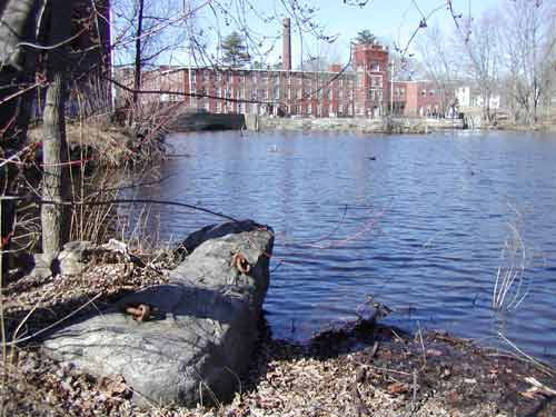
Figure 1. Floating towpath anchor stone (foreground); Middlesex Canal Museum and Visitors Center, Faulkner Mill (background).
Photo by Robert Winters
According to the historical record, a prominent feature of the floating towpath was that it could be parted or opened to allow debris to be cleared away from the upstream side, to enable boats or rafts of logs to enter or exit the canal from the river, and, in conjunction with the nearby Oak Lock, to allow boats traversing the river to bypass the mill pond dam. (This feature may have accommodated the passage of Henry David Thoreau and his brother, in 1839, when they made the trip that became the basis for the book A Week on the Concord and Merrimack Rivers, published a decade later.) But how was this opening accomplished?
By whatever means, it seems probable that some sort of device would have been needed to draw at least a segment of the towpath apart, possibly like a gate, from a larger fixed section. Likely, this gate would have been drawn upstream using a block and tackle or winching mechanism or the strength of animals. If the former, some hard point would have been required, some distance upstream, to anchor the fixed end of the mechanism. The location of such a hard point has not yet been discovered and may have been destroyed when a parking lot was built in the area immediately adjacent to the shore at this site.
Initially, boats were pulled across the river by one of the crew who walked the floating towpath, the first version being inadequate to support the weight of a draft animal. At this time, the animals were detached from their towline and led by another of the crew over the dam and around to the opposite shore. Later, the floating towpath was enlarged to carry the weight of an animal. Eventually a railing was added, reportedly to reduce the tendency for animals to spook. (Its purpose may also have been to keep the draft animal from being swept off the towpath if the boat or towline snagged on something or the object under tow was pulled away by the river current.) In its ultimate form, given that rafts of logs constituted frequent cargo on the canal, it seems probable that the flotation would have had to be sufficiently robust and buoyant to support at least a single ox, and perhaps the two of a single yoke.
There were other requirements that would have been met. The towpath would have had to accommodate to changes in the level of the Concord River. And it would have had to either be pulled out before the river froze over at the end of the season, or be otherwise protected to avoid ice damage; and then reinstalled after ice-out in the spring. (If the towpath was constructed in lock-lengths and widths, then upon disassembly, the sections might have been floated into the canal beyond the guard gates and "grounded" by draining that section of the canal.)
All very intriguing; and until recently the above description and speculation would have been a reasonable summary of about all that was known about the floating towpath. But how was it actually built?
Regrettably, no builders notes that describe the actual design and/or construction of it are known to exist. But in the Mogan Center for Lowell History (repository for those papers that belong to the Middlesex Canal Association) there is a book of photographs of the Middlesex Canal (compiled in March, 1968, by Charles T. Sheldon using his own photographs together with some from other, earlier contributors). Among the many photos are a few of the Concord Mill Pond basin at a time when the pond had been completely drained.
Clearly visible in these photographs is a single stone-filled timber crib at the western tip of the causeway. Then, increasingly out of focus, there appear to be two additional timber cribs spaced perhaps one quarter and three quarters of the way between the tip of the causeway on the east side of the river and the western shore. (These are eyeball estimates; the photographs are pretty fuzzy.)
With the timber cribs in mind, a careful examination of an 1825 painting of the floating towpath (possibly of the early packet George Washington under tow) reveals a small dark line at the junction between the causeway and the floating towpath, between the horses rear hoofs. See Figure 2. Could this be artist's depiction of the timber crib at the end of the causeway? Is this the abutment for the east end of the floating towpath?
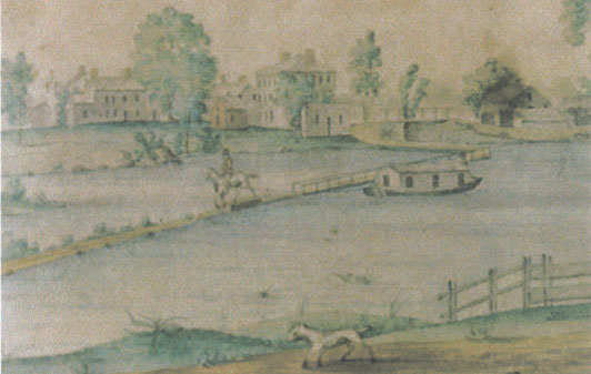
Figure 2. The Floating Towpath across the Concord River at North Billerica. Water color by William Barton, 1825.
From the Harriet B. Rogers Collection of the Billerica Historical Society
There is a also question regarding the function of the anchor stone. Though impressive in size, it seems puny in comparison to the power of a raging river; i.e., if the stone really was the primary anchor and the towpath was subjected to great strain, e.g., from spring freshets acting against it and whatever debris might have accumulated, this stone would likely be ripped from its perch.
Furthermore, aerial photography of the site suggests that the causeway points not to the stone but to a perturbation in the bank a short distance upstream of the stone. Could this point have been another timber crib. And if so, then what purpose would the anchor stone have served? Could it, instead, have been used in some way for the seasonal disassembly and assembly of the towpath? Or could it have been the hard point for a means to close the towpath, after it was opened to accommodate the cleaning of debris or the passage of river traffic? Could it have been used simply to stabilize the towpath itself?
If this is correct interpretation, then the arrangement of timber cribs and anchor stone might be somewhat as shown in the plot-plan of Figure 3.
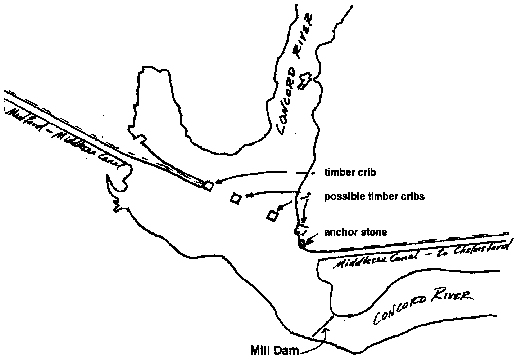
Figure 3. Possible placement of Timber Cribs to support the Floating Towpath
At this point we can only speculate about the remaining construction features. It seems likely that the towpath would have been floated on barrels or hulls, something that would not become water logged over time and which could be serviced and repaired as needed. And likely it would have been built in manageable sections that would have been assembled over or between each of the several timber cribs. And finally, was a timber crib (or the anchor stone) the pivot point for the section of towpath that could be opened? If so, might an opened towpath look about as shown in Figure 4?
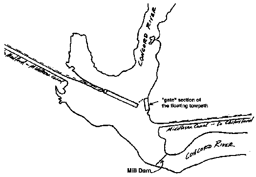
Figure 4. The Floating Towpath with a section gated open
Other interpretations of the photographs and their captions are possible, as are other interpretations of what is known and said about the floating towpath. A modicum of archaeology work in the pond might shed additional light on its design and construction. Or perhaps, someday, someone will find builders notes that will further define the design and construction of it. But until then, the foregoing descriptions and speculation may be about as good as we can do based upon what we think we know.
COST TO BUILD THE MIDDLESEX CANAL IN THE 21st CENTURY
by Howard Winkler
Background
I have been a member of the Middlesex Canal Association since 1967, and over the many years I would from time to time think about the cost of constructing the canal. In 2001, David Dettinger, a long time director, and the premier host and principal presenter of our bicentennial talk series, asked me if I would give the tenth talk the next year. How does one say no to a person such as Dave who has set an example of diligence in putting together so many interesting presentations? I said that I would do it and kept my apprehension to myself. I had my topic in mind, and now all I had to do was to develop it into a one-hour graphic presentation in a years time. On Sunday afternoon, November 3, 2002, I delivered the Tenth Annual Bicentennial Talk titled Building the Middlesex Canal in the 21st Century at the Middlesex Canal Museum. Roger Hagopian videotaped the talk for the record, but nothing is better than hard copy for long-term documentation, so I chose to write up the cost part of my talk, and it follows with a few changes.
Historical Cost
After William Weston completed his survey of the canals route in 1794, he estimated the cost of the undertaking to be £100,000 or $333,333 lawful money of Massachusetts. This estimate only covered the cost of construction from the Merrimack River to the Mystic River, a distance of 17 miles. It was decided later to build the canal to Boston Harbor rather than to use the channel of the Mystic River as the conveyance. Rivers are not dependable, often being too full in the spring and having insufficient water in late summer. (The canal was eventually dug to the Boston Harbor requiring an additional 10 plus miles of construction.) In Gallatins report, it was stated that the total cost of the canal was $536,00 of which $478,000 was for the capital expended on the work and $58,000 for the water rights and land costs. Construction cost has to be in terms of current costs to be meaningful, so it is necessary to put 18th/19th century costs in terms of 21st century dollars. Canal construction was initiated in 1794 and completed in 1803.
Two approaches were followed. The first approach was to find an historical price index that spanned the period from the ten construction years to 2001, and the second approach used was to estimate the cost of building yesterdays canal today based on the original canal design. Both approaches were fraught with uncertainties, and it was hoped that that the results would be consistent and so support each other.
Cost Based on Historic Price Estimate
Price indices for the ten years of construction were averaged to obtain a starting reference.
The first historic price index that comes to mind is the Consumer Price Index. Using this measure it was found that the 18th/19th century cost of $536,000 projects to about $8 million dollars in 2001. This was patently too low. The Consumer Price index fails as an index to project canal costs because it is comparing things that the average household buys such as food, housing, clothing, transportation, and medical services. It does not, for example, include bridges and bulldozers.
Gross Domestic Product (GDP) was also considered. GDP is a measure of all the goods and services produced by the economy in a year. The $536,000 cost in the 18th/19th century translates to $11 billion in 2001. The GDP figure gives a sense of how large a project we would have to undertake today to be of the same scale to reflect the same share of GDP. Use of GDP as a measure of relative construction cost also fails because there are so many more Americans today contributing to the economy than in 18th/19th century time period.
(It is worth noting that an $11 billion effort today is within the cost range of the Big Dig. John Ciriello, an MCA member, referred to the construction of the Middlesex Canal as the First Big Dig. It is certainly an appropriate name.)
The measure that was ultimately used to assess the relative cost was the GDP per capita which is an index of the economy's average output per person. Using this measure, the construction cost of $536,000 in the 18th/19th century translates to a $208 million cost in 2001.
Cost Based on Engineering Estimate
The requirements for construction were to build a canal 1) from the Merrimack River to Boston Harbor a distance of 27.25 miles with a prismatic cross section that is 20 feet across at the bottom, 30.5 feet across the top, and 3.5 feet deep, 2) capable of carrying a boat whose length is not more than 75 feet, whose width is not more than 9.5 feet, and 3) using the effort of one horse.
The design specification for construction in 2001 was unchanged from 1794, and required 20 locks, eight aqueducts, one towpath bridge, and 48 public and private (accommodation) bridges.
It was assumed that only modern construction techniques would be used. In 1794, men and animals were the only source of power. To build the canal today as it was constructed then would be very labor intensive, and the construction skills used then have been largely lost today. For example, in 1794, locks were constructed of stone or wood, and today wooden forms with reinforcement bars would be put in place and filled with concrete.
If the canal were built today, it would be straighter and so shorter because modern power equipment could cut the hills, fill low areas, and remove and replace unsuitable soils more expeditiously. Unsuitable soils are those for which settlement would be expected and so require significant preparation. An example would be the sinking meadow as it was called in the 18th century. Therefore, today, there would be no ox bow in Wilmington. The ox bow represented a limitation in construction ability. Rather than filling in an unsuitable soil, the builders of that time chose instead to go around. A shorter canal would also result in less land taking. It would be further expected that there would be fewer locks and they would be deeper through the use of modern power equipment to prepare the canal bed.
Cost assumptions assumed 1) construction through undeveloped land, 2) no relocation of roads and buildings, 3) no relocation of utilities, that is, water, sewer, power, telephone, coax, 4) no remediation of contaminated soil, 4) no unusual legal impediments, and 5) a three year construction period.
Todays design and construction would have to consider rules and regulations imposed by 1) Environmental Protection Agency, 2) Occupational Safety & Health Administration, 3) Americans with Disabilities Act, 4) Army Corps of Engineers, 5) Chapter 91, Massachusetts General Laws requiring no impediment to waterway navigation, 6) US Department of Transportation, 7) Department of Labor, and 8) union rules. In the 18th/19th century period of construction, these constraints did not exist, save for infringement of water rights.
Special consideration was given to 1) sealing the prism of the canal against leaks, 2) construction of a canal prism in unsuitable soils, 3) land acquisition costs, and 4) the floating bridge.
During construction of the canal, a process called puddling was used to abate the leaking and weeping of water from the embankments in porous soils. Fine soil would be mixed with clay and water until it was in a plastic state. This material would then be spread as a thin layer and built up by repeated applications. The resulting puddle could be two to three feet thick. It did not work well, and puddling is too labor intensive to be considered in modern times. Instead, for 21st century construction, the entire 27.25 miles of the prism of the canal was lined with a 0.060-inch thick high-density polyethylene membrane. This membrane is used as a field lining system in landfills, reservoirs, lagoons, wastewater ponds, farm ponds, and canals. Sandwiching the membrane between two six-inch layers of sand protects it from damage. The top layer of sand is covered by six inches of riprap for additional protection.
In the 21st century, if it was found that it was not feasible to excavate the unsuitable soil and replace it with stable backfill, e.g., sand, then the area would be crossed with a concrete flume with a prismatic shape similar to the canal, supported by piles driven into bed rock or load bearing glacial till.
Care was taken in developing the cost of land acquisition, lest it overwhelm all other costs and so distorts the result. The cost numbers presented in the Gallatin report indicated that the water rights and land costs were almost eleven percent of the total cost. The approach taken was to try to keep the ratio of land acquisition cost to total estimated construction cost including land acquisition cost about the same. Much of the canal route was built over wetland, the virtue of which is that it is level and reduces the need to cut and fill. Information obtained from the assessors offices in Billerica and Wilmington indicated that the current price of wetland is about $70,000 per acre which is the cost used in this analysis. It is interesting to compare land costs in eastern Massachusetts today with the current cost of land in rural Aroostook County Maine where 50-acre parcels are selling for $645 per acre. No water rights were purchased in developing the 21st century cost. Land cost acquisition assumed no impediments, so there would be no extraordinary legal fees. This is a big assumption in our litigious age.
A fixed bridge supported on pilings was substituted for the floating bridge. Since there are no longer log drives on the Concord River there is no need to design a structure that does not impede the flow of the river at the dam in Billerica.
Annotated cost elements are presented in the accompanying Middlesex Canal Cost Buildup table in descending order of magnitude. It is shown that the total estimated project cost including land acquisition cost is $189.9 million and the land acquisition costs are estimated at $21.3 million. The total area of the canal is 231 acres including the berm and towpath. It was assumed that twice the area was required. The additional acreage would provide space needed for road construction, working space, and for sites to store building materials and equipment. The 462 acres would be purchased at a cost of $70,000 per acre. After construction, 231 acres would be sold at $50,000 per acre. The net land cost would be $19.3 million plus $2 million for legal fees for a total land cost of almost $21.3 million or about eleven percent of the total cost.
The total estimated project cost is shown in the accompanying table is $213.9 million.
21st Century Estimate
Two cost estimates were developed for building the Middlesex Canal today. It was fortunate that they are in approximate agreement. The estimate arrived at using an historic price index resulted in a cost of $208 million, and the estimate made based on pricing construction yielded $214 million. Both of the analyses were given equal weight so it was decided use the arithmetic mean value that is $211 million, and round off the result. It was concluded that the cost to build the canal today, in the 21st century would be about $200 million.
To give this cost estimate perspective, it should be realized that the canal is but a precision bulldozed ditch with some expensive appurtenances.
Bibliography
Report of the Secretary of the Treasury (Albert Gallatin) on the Subject of Public Roads and Canals, 1807, an annex of A Treatise on Internal Navigation, 1817
Christopher Roberts, The Middlesex Canal, 1793-1860, 1938
Lewis M. Lawrence, The Middlesex Canal, 1942
EH.Net (consortium of economic history organizations), What is its Relative Value?, www.eh.net/hmit/compare
Camp Dresser & McKee, Inc., Cambridge, MA, cost estimating data
Acknowledgments
I want to thank my younger son, James Winkler, a chemical engineer, for developing the cost estimates, my daughter, Anne Winkler, an economist, for finding measures of relative value and helping me to interpret these measures, my older son, Mitchell Winkler, a civil engineer, for providing some modern design approaches, Wilbar Hoxie, an MCA Director, who helped me understand some of the design features of the original canal, and David Dettinger, another Director, who made available to me his books on the subject.
MIDDLESEX CANAL COST BUILDUP
| Task | Cost, millions of $ | |
| bridges (48); public and private (accommodation) | 36.0 | |
| canal; cut and fill sections with polyethylene membrane sandwich | 22.0 | |
| canal supported sections; concrete flumes resting on piles | 12.5 | |
| aqueducts (8); river crossings | 8.0 | |
| locks (20); chamber, gates, and machinery | 6.0 | |
| waterway connections (4); Charles (1), Concord (2), Merrimack (1) | 4.5 | |
| landings (8); cargo and passenger loading and storage facilities | 4.0 | |
| towpath bridge (1); fixed structure | 3.0 | |
| support infrastructure; roads and storage areas for materials and vehicles | 3.0 | |
| fencing; safety | 3.0 | |
| clearing and grubbing; cutting trees and removing stumps | 3.0 | |
| basins (28); to allow boats to pass and anchor | 3.0 | |
| additional fill volume; leveling | 2.0 | |
| additional cut volume; leveling | 2.0 | |
| sluiceway and guard locks (28); gates to spill water and prevent spillage | 1.0 | |
| culverts (20); carry small streams under canal | 1.0 | |
| blasted rock; beyond earth moving equipment until reduced in size | 1.0 | |
| environmental protection; silt fences and hay bales to retard runoff of soil | 0.2 | |
| construction cost | 115.2 | |
| contingency - 20% | 23.0 | |
| construction cost with contingency | 138.2 | |
| engineering (survey & design) - 9% | 12.4 | |
| construction management | 18.0 | |
| total estimated construction cost | 168.6 | |
| land acquisition costs | 21.3 | |
| total estimated construction cost and land acquisition cost | 189.9 | |
| linkage to communities for inconvenience; nine cities and towns | 9.0 | |
| environmental impact assessment; technical and community impact | 8.0 | |
| permits; State and Federal | 5.0 | |
| OSHA compliance; on-site staff | 2.0 | |
| 21st century considerations | 24.0 | |
| total estimated project cost | 213.9 | |