![]()

Middlesex Canal Association P.O. Box
333 Billerica, Massachusetts 01821
www.middlesexcanal.org
| Volume 43 No. 1 |
September 2004 |
43rd Annual Old Middlesex Canal Fall Walk
Middlesex Canal Association - Appalachian Mountain Club
Date: Saturday, October 23
Time: 1:30pm
Depart from: Middlesex Canal Museum, North Billerica
Our 43rd Annual Fall Walk will originate at the Middlesex Canal Museum and Visitor Center at the Faulkner Mills on Faulkner St. in North Billerica. The Museum and Visitor Center, and bookstore, will be open from 12 noon to 4pm. The walk will cover the route of the canal south of the mills. Sites will include a lock, an anchor stone for the floating towpath that once spanned the Concord Mill Pond, and many stretches of watered canal. The walk will cover about 3-4 miles over generally level wooded terrain and streets in about 2-3 hours, rain or shine.
Directions: From Route 3 , take exit 28, Treble Cove Rd. At end of ramp turn left toward North Billerica. At about ¾ mile bear left at a fork, and pass through traffic light crossing Route 3A. Follow the winding road then straight passing to the right of St. Andrews Church. Bear right onto Elm Street as you approach the mills and continue across the bridge at the dam. Immediately turn right into the parking lot on the right just after the dam. The Middlesex Canal Museum and Visitor Center is directly across the street.
For more information call walk leaders: Bill Gerber 978-251-4971 and Roger Hagopian 781-861-7868, or check out our web site: www.middlesexcanal.org
Upcoming Events:
Fri, Sept 17, 6:00pm: Free 50’s Band Concert at the gazebo area across from the Faulkner Mills next to the Concord Falls. Sponsored by the Faulkner Mills. The Middlesex Canal Museum will be selling hot dogs, drinks, popcorn and candy all at $1.00 each to support the Museum. Bring a chair and come watch the concert.
Sat, Sept 18, 12:00-4:00pm: Yankee Doodle Homecoming (Billerica)
Annual town celebration. Parade and events behind the High School and at the
Museum.
Sat-Mon, Oct 9th, 10th, and 11th – Canal Heritage Days:
Sat, Oct 9 (Lowell): NHPS speakers, canal boat rides, evening walk. See Lowell National Historical Park website (www.nps.gov/lowe) for details.
Sat, Oct 9, 9:00am-3:00pm: Bike ride along route of southern part of Middlesex Canal from Sullivan Square to North Billerica. Meet at Sullivan Sq. at 9am. See Middlesex Canal website for more details.
| Sun, Oct 10 (Middlesex Canal Museum, N. Billerica) | |
| All Day | Ongoing tours of Museum |
| 10:00 - 10:45am | Dave Dettinger – “Overview of Middlesex Canal” |
| 10:45 - 11:30am | Nolan Jones, President, MCA – “Canal as it is Today” |
| 12:00 noon | Lunch available (Home Cookin’ Café) |
| 12:30 - 1:00pm | Paul Wiggin, Canal Troubadour – Singing |
| 1:00 - 2:00pm | Mill Village Narrated Walking Tour by Alec Ingraham |
| 2:00 - 3:00pm | Kevin Gilligan (CREST) – “Concord and Merrimac River” |
| 3:00 - 3:30pm | John Ciriello - “Artifacts·uncovered in Tay Tavern, Woburn” |
| 3:30 - 4:00pm | Betty Bigwood - “Patch’s Pond, Wilmington, MA” |
| Ongoing children’s activities at the Museum –
Scavenger hunt; Drawing area - “What is a Canal to You” mural; Tabletop weaving area; Make a canal boat. |
|
Sun, Oct 10, 1:30pm: Bike Ride from Lowell NHP Visitors Center along Riverwalk and Northern Canal to Francis Gate, then following Middlesex Canal route to Museum in N. Billerica. See website for details.
There will be 3 stamp cancellation stations (Lowell National Historical Park, American Textile History Museum, Middlesex Canal Museum) where visitors can purchase a postcard or collector’s envelope and stamp for cancellation by the USPS on the day of the event. The Middlesex Canal Museum will be “Faulkner Mills Station” and will have envelopes with the special cachet printed on it. Tom Dahill’s painting “Floating Tow Path 1810” is this year’s logo and will be featured on posters and as the cachet on the envelopes. Stamp collectors can go to each of the sites to obtain individual cancellations.
Sat, Oct 23, 1:30pm: MCA-AMC Fall Walk (North Billerica)
Sun, Nov 7, 3:00pm: Fall Meeting - Nolan Jones will speak on “The Middlesex Canal Today” and show new color slides of historic buildings and canal sites to support our application for the National Registry of Historic Places.
2nd Annual New Year’s Day Celebration 2005
As the Town of Billerica begins its 350th anniversary, the Museum will host an
opening of “Pictorial History of North Billerica.” Photographic exhibit
focusing on the Faulkner Mills and the developing community of North Billerica
around the mills between 1890-1910. This is an Eagle Scout Badge presentation by
Zeb Couch. After a private ceremony, the exhibit will open to the public for
viewing from 3:00-5:00pm. Refreshments will be served.
President’s Message
Tom Raphael and Susan Keats are almost finished with our application for the National Registry of Historic Places. We are getting organized for the final phases of public meetings and presentations. I am committed to shooting slides and prints for this. I will use those new slides in talks that are coming up including the Canal Heritage Days.
Canal Heritage Days planning is underway. They will be held on the Columbus Day weekend, October 9 & 10. The program on the 9th will be at the Lowell National Historical Park (LNHP) and the 10th will be at our Museum in North Billerica. A group from the Canal Society of New Jersey will be visiting the event.
In addition to a talk as part of the Canal Heritage Days, I have three talks planned: October 19 at the Middlesex Community College; January 18 at the Peabody Museum in Andover; and April 19 at the Wakefield Historical Society. If you or your group would like an illustrated program relating to canals here or in Europe, please let me know.
Nolan T Jones, President
The Pleasure Barge
by Howard B. Winkler, Treasurer
In preparing the Tenth Annual Bicentennial Talk, “Building the Middlesex Canal in the 21st Century,” I was struck by a passage on page 110 in Christopher Robert’s The Middlesex Canal which described a pleasure barge.
Junketing trips for directors, for shareholders whose morale was flagging, and for prominent personages visiting the region were frequent after 1800. Records of Babylonian feasts, always a feature of such occasions, show amazing lists of meats consumed at one sitting. John Coffin Jones, Samuel Parkman, and ten other shareholders, many of whom had never seen the canal, plus servants, comprised one such party; Governor Trumbull of Connecticut, General Pinckney of South Carolina, and Colonel Humphreys were among the principal figures in another. Gaudier than a circus wagon was the pleasure barge that bore them. The black bottom and white wale line contrasted with the vivid red of the wale and quarter railing; the awning, the posts, and the inside of the top were a light blue; the seats and the interior to the coping above the timber heads, “a strong high Orange.” Such voyages were an outward show, a painted veil thrown before the ugly face of facts. On the ground, over the line of work, Baldwin toiled and struggled with unforeseen problems, made mistakes, and bore the consequences.
These junketing trips were the 18th century equivalent of the very modern booze cruises provided by the Massachusetts Port Authority for people it sought to influence. I sent Tom Dahill, our Vice President and resident artist, an email and asked him to please put the words into a picture, and this resulted in the water color painting that follows.
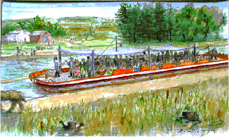
The Pleasure Barge - watercolor by Thomas Dahill
Tom Dahill’s painting shows James Sullivan who conceived the idea for a canal, and who was also its principal promoter, as well as the first president of the canal company lading out adult libations to his guests. It is guessed that the painting shows the state of things at the beginning of the voyage since the guests are all standing, and no one has fallen overboard! The creatures in the foreground are muskrats which were the bane of the canal due to their habit of digging and breaching the watertight integrity of the sides of the canal.
It makes you wonder what was going on when the pyramids were being built.
Our Spring Walk 2004
By Roger Hagopian, with contributions by Howard
Winkler
Our Spring Walk commenced at Winchester, where the remnants of the Middlesex Canal meanders from the land of the (former) Metropolitan District Commission to the streets and neighborhoods of Medford. The climate was perfect for this event. As usual our walkers, which numbered about 30, consisted of a mix of historians, nature lovers, bird lovers, and fitness folk.
Led by co-leaders Howard Winkler and Roger Hagopian, the group proceeded from Sandy Beach on the Mystic Lakes in Winchester to the site where an aqueduct once carried the canal over the Aberjona or Symmes River at the north end of the upper lake. During the canal era this was location where the river entered into the lakes. However, in 1863, a dam was constructed between the Upper and Lower Lakes, once known as Medford Pond, thus elevating the water level for conversion into a reservoir for the city of Boston’s drinking water supply. As a result, the Aberjona/Symmes River has now taken the form of a smaller third lake just above the aqueduct site.
In 1865 the aqueduct was blown up to relieve ice jams created by the stone arch structure. Its remains were used in the construction of the house and stable of the nearby Shepard Brooks estate, as well as a barn on the Brooks family estate. The remaining stones lie scattered in the Winchester Town Forest and at the base of the aqueduct site, where some were reused when the Metropolitan District Commission built an overlook platform there.
Not far from the aqueduct was a canal basin for packet boats and barges awaiting their turn to cross the narrow trough. The semi-circular depression is still clearly visible.
Based on an article in the New England Magazine, 1898, and a map of the installation of the sewer line between Medford and Winchester, it is clear that the pipes had been laid in the bed of the Middlesex Canal with manhole covers sporadically marking the route. Realizing that the canal, the Boston and Maine Railroad (formerly Boston and Lowell), the parkway, built in the 1890s, and the sewer line all occupied the same strip of land along the eastern shore of the Mystic Lakes, our group of walkers traced the course of the canal to Medford.
We never quite made it to the Mystic River, our intended terminus, and, perhaps in the future we will arrange to have a car shuttle as we have in the past, to avoid the redundancy of retracing our steps.
The North Canal at Lawrence
by Bill Gerber
[I wish to thank Dave Barber, President of the American Canal Society, Jim Beauchesne, Historian at the Lawrence Heritage State Park, and members of the Chelmsford Writer’s Group for their assistance in preparing this article.]
The Past
The Essex Dam and the North Canal, at Lawrence
Massachusetts, were built to provide water power to the textile mills of
Lawrence. The inclusion of a transportation component within the North Canal was
required by the legislature of Massachusetts to maintain river navigation. Prior
to construction of the dam and canal, boats, rafts and masts negotiated the
Merrimack using bypass canals or other improvements at a succession of the river’s
falls and rapids.
Timber products remained important for ship building in Newburyport and for the construction industries in all the towns along the Merrimack River. Water powered saw mills were opened in Lowell, and probably other river towns as well, to satisfy an ever increasing need for materials. To meet the demand, timbering companies continued to float rafts of logs down the Merrimack throughout the 19th century, well after the upper Merrimack Canals were abandoned. The North Canal, and that other survivor of the canal era, the Pawtucket Canal, provided the means to bypass the principal dams in Lowell and Lawrence.
At least one reference states that the Essex Dam was built at the site of Bodwell’s Falls, and it appears that the lake created behind the dam flooded out at least three other falls further upstream: i.e., Peter’s, Parker’s and Varnum’s. Two additional falls, Mitchell’s and Hunt’s, remained exposed downstream and upstream, respectively, of the North Canal.
The North Canal was completed and opened for service in 1848, only a few years before the system of canals on upper Merrimack River and the Middlesex Canal were abandoned. As shown in Figure 1, the North Canal was about a mile in length and incorporated a guard lock at the west end of the channel, and three lift locks in a staircase at the east end. The three-lock staircase provided a lift of about 29 feet to overcome the height of the Essex Dam. A lock tender’s house was located near the top lock of the staircase.
The locks were of rough masonry with a wood liner and used wooden miter gates. Their chambers were 20’ wide by 100’ long, similar in size to those of the Pawtucket Canal, which had been 25’ x 110’. However, by the time this canal was built, the Proprietors of Locks and Canals on [the] Merrimack River had obtained permission from the legislature to reduce the size of their locks to a width of 12’ to save water, which by then was needed to power the mills of Lowell. This action was complete by 1841, several years before the North Canal was built.
The North Canal continued in operation until it was abandoned in the early 1960s. At that time, the upper gates were removed from the guard lock and the channel was blocked above the sill with an arched wall of concrete blocks. The lower guard lock gates remain in place. At the other end of the canal the lower locks appear to have been completely filled in with earth.
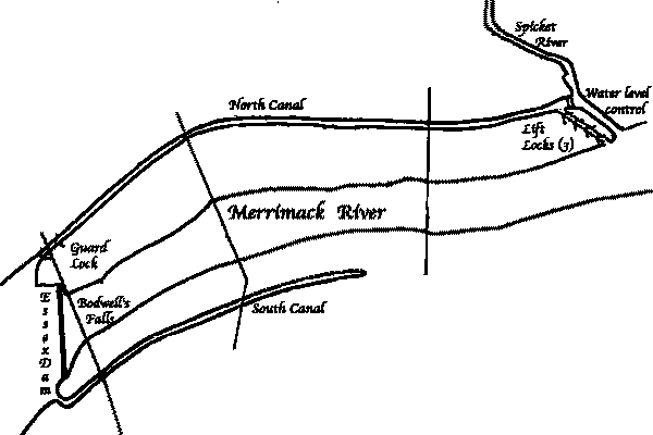
Figure 1: The North Canal at Lawrence, showing the original transportation
components; i.e., the guard and lift locks
The Potential
In England, several thousand miles of old canals have
been restored throughout the country for recreational and commercial tourist
boating. In the cities and towns, parks have been built focused on the restored
canals and hundreds, if not thousands, of pubs have been built or adapted to
face out onto the canals. On a sunny summer day, throngs of people turn out to
watch colorful boats negotiate locks or simply pass by. Recreational boaters are
frequent visitors to onshore stores, markets, museums, other tourist sites and,
of course, the pubs. And anglers by the dozens try their luck at catching the
fish that inhabit the canals. (The canals, by the way, are usually cleaner than
some of the rivers.)
In contrast, in Lowell Massachusetts, the National Park Service has restored portions of the old Pawtucket Canal, including Warren Locks at the outlet to the Concord River. Immediately adjacent to these restored locks is the Double Tree Hotel which boasts a patio abutting Warren Locks. But, alas, no one goes there! This is similarly true for the Chesapeake and Ohio (C&O) Canal, in and west of Washington DC, also restored by the Park Service, though there at least the tow path is used by walkers and bicyclists.
What’s the difference? The most obvious difference is that no boats lock through either the Pawtucket or the C&O canals. In both cases, civilian boats are not permitted by park service regulations; and, in the case of Warren Locks, even the service’s own boats don’t use them. And so there is nothing of more than passing historical interest in a pair of restored locks to draw people to this site.
More than a century and a half ago, the Merrimack was navigable from Concord NH to Newburyport MA and there was a significant amount of commerce that depended upon the river for transportation. Could at least a portion of the Merrimack be restored for through navigation today? Could the North Canal be reopened? Dave Barber, President of the American Canal Society, has investigated the potential for restoring the North Canal. Many of the remaining observations are summarized from several of his recent reports, also from comments of Jim Beauchesne, Historian at the Lawrence Heritage State Park.
Presently, the Essex Dam and the North Canal are owned by Enel, an Italian-based company which recently bought the hydroelectric plant on the South side of the dam. Enel is now the legal successor to the Essex Company. Although no mills are currently drawing water from the North Canal, two mill-owners are in discussions with Enel about resuming the use of canal water for power. (Currently, a paper mill draws water from the south canal, a post-Civil War power canal which had no transportation function.)
To a considerable extent, unless the river was dredged, the size of craft that could negotiate the Merrimack would be limited by whatever channels exist or could be cleared in Mitchell’s, possibly Varnum’s (which can sometimes be seen during low water conditions), and Hunt’s Falls. These are shallow ledges downstream and upstream, respectively, of the North Canal. That even small boats will be able to reach the North Canal will likely depend on the restoration and maintenance of whatever “improvements” were made to these falls long ago.
In about 1796 or ‘97, these and other falls since flooded out were “improved” by The Proprietors of Locks and Canals on [the] Merrimack River, to make the river navigable for boats, rafts and masts in accordance with the terms of their act of incorporation. However, no current authority or mechanism is known to be responsible for performing such restoration or maintenance.
In the summer, the Merrimack is marked by buoys up to Haverhill, but not navigated beyond due to rocks. It may be that people don’t boat from Haverhill to Lawrence because the channel isn’t marked; and it may not be marked because it’s no longer the established practice.
There appear to be no barriers to navigation at Haverhill. Here the river is wide and crossed by three bridges. The first bridge carries road traffic. It consists of multiple spans, all but one of which are supported by concrete arches of 1930’s era construction. However, there is a control tower at the third span from the north end and the span itself is a two-leaf, steel bascule drawbridge. This drawbridge is now fixed in place and carries an insulated pipeline along its side, but the free space between the bridge and the water is about 30 feet with the bridge closed.
About two city-blocks upstream there is a multiple span steel truss railroad bridge. While most of the spans are of the deck truss variety, the second span from the north shore is a through-truss type that provides an obviously navigable channel beneath it. Furthermore, this channel lines up with the bascule span of the first bridge.
Just upstream of the railroad bridge there is a highway bridge that, according to its placard, was built in 1906. This is a multiple span, through-truss, metal bridge. It is now closed to vehicle traffic, but the sidewalk on the downstream side is open and in excellent condition. The piers of this bridge line up with the railroad bridge, and the height of this bridge above the water is adequate to clear anything that could pass under the other two bridges.
There was a World War I era proposal to build a ship channel to Lawrence, which probably explains the bascule bridge and the alignment of specific spans of the other bridges at Haverhill.
Proceeding west on Rte. 113, there appear to be no obstructions upstream along the north bank. The only other bridges are for I-495 and these are all quite high above the level of the water.
Delorme’s Street Atlas USA notes “Mitchell’s Falls” about half way between Haverhill and Lawrence. This part of the river is visible from Rte 110/113, but there is no significant drop in level and only a few rocks along the left bank. Obstacles were probably removed here, a channel cut and possibly a wing-dam constructed in about 1796. The historical record indicates that this was also done at five other falls further upstream, all but one of which have since been flooded out by the lake behind the Essex Dam.
In Arcadia’s “History of Lawrence”, volume 1, page 15, there is an 1897 view of the lower three locks of the North Canal with all west side gates open except the upper gates of the top lock. The east side gates are closed. The locks are lined with wood plank but there is masonry on retaining walls. The photo caption notes that a building in the background at the head of the locks is the lock keepers house. The buildings are now gone and the flight is filled in.
Today, there is a water level control facility and spillway at the east end of the canal. Just upstream of the spillway there is an interruption in the masonry wall along the south bank. Here, an earth fill extends into the canal that is on the same alignment as the locks shown on the map in the visitors’ center. The entrance to the top lock of the staircase flight was probably here. Nothing is built on the alignment.
At the west end of the canal the gates at the upper end of the guard lock have been removed and rows of concrete blocks have been laid above the upper sill to close off the channel. At the downstream end of this lock, there is space under the bridge to swing the balance beams of the intact lower miter gates, although the existing balance beams appear to have been cut short.
On several weekday surveys along the entire length of the one mile long canal, none of the intake gates to the factories were raised or in use. Thus it would seem that the North Canal is no longer used for power. It appears that it is a watered but unused canal with restorable locks at each end, on unused sites, in a financially depressed city.
Assuming that the lift locks were not destroyed, but simply been filled in, it would not take a monumental effort to restore this canal to navigation. Furthermore, if it could be reopened, the last set of locks on the Pawtucket Canal restored (i.e., Swamp Locks) and Park Service’s policies changed, then navigation for at least small boats could be reestablished over more than 50 miles of the Merrimack River, from tidewater all the way to Merrimack, NH. And, with a little work at Cromwell’s Falls, arguably the best preserved of the early Merrimack River transportation canals (located at the southeast corner of the Anhauser-Bush Brewery’s property) navigation could be extended up as far as Moor’s Falls at the north end of Litchfield, NH.
But if it was restored, would small boats use it?
[The author, Bill Gerber, resides at 16 Princess Ave., N.
Chelmsford MA 01863
and may be reached via e-mail at <bill_gerber@bostonbbs.org>.]
Canaling in “Old” Europe in 1876
by Alan Seaburg
Robert Louis Stevenson and his friend Walter Grindlay Simpson made in the summer of 1876 a canoe trip on some of the canals and rivers of “old” Europe. Two years later Stevenson published an account of their adventure as An Inland Voyage which is as delightful as the later tales of his Travels with a Donkey although one must say that Simpson was never as stubborn as was his donkey companion Modestine.
The young men launched their two canoes, one made from cedar and the other from English oak, from the docks of Antwerp harbor. “The sun shone brightly; the tide was making four jolly miles an hour; the wind blew steadily, with occasional squalls.” Using sail and with “a fluttering Union Jack on each” canoe they were soon a part of the river traffic to Boom where they spent their first evening. Their plan was simple: by daylight they were voyagers and at night hostelers. Their hope was to paddle by canals and rivers through to the Mediterranean but they only got as far as Belgium and north-eastern France. Paddling in all sorts of weather proved to be harder than they had anticipated. They also found that they missed the bustle and merry life of the city. In Stevenson’s case he also missed the ladies.
The next morning found them on the Willebroek Canal. The weather was chilly and rainy and as a result “the water of the canal stood at about the drinking temperature of tea.” They were well on their way to Villevord when the sun finally managed to come out of the clouds. Stevenson enjoyed watching the various barges he saw as they journeyed the canal and pondered himself the captain of one. “Of all the creatures of commercial enterprise,” he ruminated, “a canal barge is by far the most delightful to consider. It may spread its sails, and then you see it sailing high above the tree-tops and the windmill . . . [and] through the green corn-lands . . . [while] the horse plods along at a foot-pace as if there were no such thing as business in the world; and the man dreaming at the tiller sees the same spire on the horizon all day long.”
That night was spent near Brussels. The next day as there were fifty-five locks ahead of them and as the canal was jammed with barges, the boys and their canoes crossed the French border and traveled to Charleroi by train. Then by river they next reached with overnight stopovers Mabeuge and Hautmont.
Eventually they were sailing down the rather pleasant Sambre and Oise canals. Sometimes a youngster ran beside them along the towpath and sometimes their companions were solitary silent fishermen. “And surely of all smells in the world, the smell of many trees is the sweetest and most fortifying . . . Usually the resin of the fir predominates. But some woods are more coquettish in their habits; and the breath of the forest of Mormal, as it came aboard upon us that showery afternoon, was perfumed with nothing less delicate than sweetbrier. I wish our way had always lain among woods.”
During their voyaging the young men passed many barges waiting for their turn at a lock. They appeared to Stevenson with “their flower-pots and smoking chimneys, their washings and dinners” as “little cities by the canal side.” Here right now but maybe gone in an hour or two. They made Stevenson want to climb aboard one and see exactly what barge life was like. So he did just that and found that he heartily approved of a “water villa”.
Indeed he and his companion were soon daydreaming of “an old age on the canals of Europe. It was to be the most leisurely of progresses, now on a swift river at the tail of a steamboat, now waiting horses for days together on some inconsiderable junction. We should be seen pottering on deck in all the dignity of years, our white beards falling into our laps. We were ever to be busied among paint-pots; so that there should be no white fresher, and no green more emerald than ours, in all the navy of the canals. There should be books in the cabin, and tobacco jars, and some old Burgundy as red as a November sunset and as odorous as a violet in April.” And this idea almost came to pass for at the conclusion of their holiday they purchased a barge, christened it the Eleven Thousand Virgins of Cologne, and had it fixed up proper and neat. But they never sailed it and so their barge “rotted in the stream where she was beautified.” Eventually it was sold along with their canoes, which they had stored thereon.
This, then, is a sampler of Stevenson’s An Inland Voyage. And while it is too often like the account of the Thoreau boys on the rivers Concord and Merrimack – bumpy with thin philosophizing – it is nevertheless a pleasing sunny afternoon’s paddling.
Notes On Early Transportation In
Massachusetts
[This article is from a paper delivered by Prof. George L.
Vose of M.I.T.
to the Boston Society of Civil Engineers, in the later days of the 19th century.
It was previously published in the October 1978 issue of Towpath Topics.]
Importance
The pioneer work of actual internal improvement in
Massachusetts, if not in America, was the Middlesex Canal, the inception and
execution of which was due mainly to one of the most distinguished men of the
last century, James Sullivan. He saw, upon the map, the Merrimac river reaching
far up into the heart of a great state, which lacked only the means of sending
its products to market to set in motion a thousands wheels of industry. “The
connection of Boston,” says Mr. Amory, in his excellent life of Sullivan, “by
a line of navigable waters with New Hampshire and Vermont, and perhaps with
Canada, became early for Sullivan a favorite project. The Merrimac, after
issuing from Lake Winnipesaukee, 120 miles from Boston, ran southerly within 27
miles of that capital, and then turning abruptly to the northeast discharged
itself, after an obstructed course of 50 miles, at Newburyport. Between Concord,
in New Hampshire, and Windsor, Vermont, the Sunapee Lake gave facility for
connecting the Connecticut and Merrimac, and the latter could be made navigable
by locks at low cost. Should the undertaking succeed between Concord and Boston,
the gradual increase of population and traffic would in time warrant its
extension to the Connecticut, and perhaps to the St. Lawrence. The first step
was a canal from Chelmsford to Boston.”
General Description
The length of the canal was 27 miles; the rise from the
Merrimac river at Chelmsford to the Concord river mill-pond at Billerica was 27
feet, and the fall from the mill-pond to Charles river 107 feet. There were in
all 20 locks, 48 bridges over the canal, and 7 aqueducts. The work was under
construction from 1795 to 1803. The cost was about $500,000, of which about
one-third was for land damages.
History
In the month of May, 1793, several gentlemen, prominent
among whom were James Sullivan, Loammi Baldwin and Jonathan Porter, associated
themselves for opening a canal from the waters of the Merrimac, by Concord river
or some other way, through the waters of Mystic river to the town of Boston; and
a committee proceeded at once to obtain a charter from the General Court, which
was signed by Governor Hancock on the 22d of June, 1793. The company organized
by the choice of James Sullivan as president, and Loammi Baldwin and John Brooks
as vice-presidents, and proceeded at once to make the necessary surveys to find
the most eligible route between Medford river and the Merrimac.
An accurate survey in those days was almost unknown in this country, and a leveling instrument was an unheard-of thing. In January, 1793, Mr. Sullivan wrote to Gen. Knox: “We are under the necessity of procuring a man who is skilled in the business of canaling, who can point us to the place where, under all circumstances, the canal ought to be cut. We hear that such a person is in Philadelphia, who has come to America on the invitation of Mr. Morris. We beg the favor of your inquiring whether such an artist is there, and whether we can obtain his aid.” The “artist” referred to was Mr. Samuel Weston, an engineer brought up in England under James Brindley.
A preliminary examination of the ground was made in the summer of 1793 by Mr. Samuel Thompson, of Woburn. He appears to have made a very careful study of the country, but was not provided with instruments of sufficient precision to obtain the elevations accurately. In March, 1974, the directors voted to send Loammi Baldwin to Philadelphia, that he might try to get Mr. Weston to make the survey for the canal, which he succeeded in doing. The surveys were commenced in July, and on the 2d of August, 1794, a full report was made upon the work. It was found that the route of the canal would be crossed in Billerica by the Concord river, which at that point was 107 feet above tide water at Boston, and 27 feet above the Merrimac at Chelmsford, being at the summit of the canal, and able to supply water in both directions.
Building the Canal
The work of building the canal was commenced in the
spring of 1795, under the direction of Col. Loammi Baldwin the elder, and
continued in the face of numerous difficulties until 1803, at which time it was
so far completed as to be navigable from the Merrimack to the Charles river. The
canal was 18 feet wide on the bottom, 30 feet wide at the water line and 4 feet
deep. The locks were 11 feet wide and 76 feet long, with an average lift of
about 7 feet. Some of these locks were made of wood, and others of stone. In the
wooden locks the side walls, which were of wood, were inclosed between rough
walls of masonry placed a few feet back of the timber-work. The masonry was thus
the retaining wall for the earth, while the timber formed a tight box for the
water, and two walls being well braced apart by struts of wood. In this way
expensive masonry was avoided, but the cost of maintenance in after years was
increased.
Completion and Abandonment
Although the Middlesex Canal was completed in 1803,
great expense was incurred for many years, owing to imperfections in the banks
and other parts of the work, and nearly the whole income was expended in
additions, alterations, and repairs, so that no dividend was declared until Feb.
1st, 1819. One hundred assessments were put upon the shares, which with interest
added to the above date, amounted to $1,455. -25 on each share, making the whole
cost of the canal $1,164,200. From 1819 to 1843 there were paid in dividends
$504 a share, averaging $20.16 per annum, being an interest on the cost of about
1.39 per cent per annum. From the year 1819 to the time when the Lowell railroad
went into operation the receipts regularly increased, so that the dividends rose
from $10 to $30 a share. The year the Boston & Lowell road was opened, the
receipts of the canal were reduced one-third, and when the Nashua & Lowell
was opened they were reduced another third. The receipts of 1842-3 were not
enough to cover the cost of repairs and current expenses.
After 1846 the traffic was small, though boats continued to run until 1852. In 1859 the charter was declared forfeited. The property was finally disposed of for about $130,000, and after the final dividend little more than the original assessments had been returned to the stock-holders.
When the Middlesex Canal went into operation it was the greatest work of internal improvement in America. It had been twenty-two years in operation when in October, 1825, DeWitt Clinton made his triumphant passage from Lake Erie to the Hudson river. Like many more recent works it produced a large indirect benefit. It was said by Daniel Webster to have added $5,000,000 to the value of the New Hampshire forests.
The Route
Commencing at the Merrimac River in Chelmsford, at a
point just above the present “Middlesex” station of the Nashua and Lowell
railway, the canal ascended through a connected flight of three stone locks, the
location of which may plainly be seen by the deep depression on the line of the
canal between the hotel and the railway, and directly in front of a small house,
which was formerly the canal office. Passing under the Main street at Middlesex
village, and over an aqueduct across Black Brook, it continued across the long
swamp to River Meadow Brook, and thence to Billerica Mills, where it entered the
Concord river mill-pond through a stone guard lock, which is still standing in
the yard of Governor Talbot’s mill. The tow-path was carried across the pond
on a floating bridge or raft, and the canal, passing out through another guard
lock just south of the road, continued on to Shawsheen River, which was crossed
by a wooden trunk about 40 feet long, supported by two Abutments and a pier of
stone. This masonry is still to be seen directly below the common road, and from
its considerable height must have been one of the most imposing works upon the
line. Half a mile further south was Nichols’ lock, and a mile and a half
further Gillis’ or Jacques’ lock.
About two miles further, and near the Poor Farm, in Wilmington, the canal crossed Maple Meadow Brook, and made an abrupt bend called the Ox-Bow. A mile further south the canal entered the town of Woburn, running along close to the west side of the traveled road, passing under it near Wilson’s tavern, running a little east of the village of North Woburn, crossing the road nearly in front of the Baldwin Place, and continuing through the western part of Woburn village, passing the rear of the present public library, it soon after reached the site of one of the chief engineering features on the route, the Horn Pond or Stoddard’s locks.
At this point the canal made a descent of 50 feet by three sets of double locks, the middle set being separated from above and below by a basin-like expansion or widening of the canal, by which the draft of water by locking was equalized. Half a mile further, and just south of the crossing of the outlet stream from Horn Pond, was a stone lock, and a mile and a half further, and just north of Abbajona River, were Gardner’s locks, which were double.
From this point the canal ran close along the shore of Medford Pond, passed through the fine grounds of Peter C. Brooks, where there is still standing a handsome elliptic stone arch built to carry a farm road over the canal. Half a mile further south was Gilson’s lock, and directly afterward the aqueduct over Mystic River. The present highway bridge rests on the piers of the old aqueduct, which have been built up to suit the grade of the present road.
From this point the canal turned east, passing under the Lowell Railroad (though the canal was built first). The wing walls of the way under the railway may still be seen cropping out of the embankment, and the bed of the canal is quite plain to the eastward of the railroad for some distance. Just in front of the old Royal House the canal passed under the road, now called Main Street, and at this point a side or branch canal about a fourth of a mile long, with a lock and a basin at the upper end and a lock at the lower end, led to the river, passing under the old Medford turnpike, and entering just below the bridge. This branch was used for transferring ship timber to Mystic River.
From this point the canal followed very nearly the base of the highland, passing through what is now the Mystic Trotting Park, at the southwest corner of which it is plainly seen, then running to the sharp bend in the river at the old toll-house, it turned to the south and passed nearly through the middle of what is now Broadway Park, curved around to the base of Mt. Benedict (Ploughed Hill of Revolutionary times) and, crossing under Medford turnpike just at the foot of the present Austin street, to the north of which the bed may still be traced by the willows that grew along the bank, it reached a lock just east of the old road over Malden Bridge, and, curving around, passed the present locations of the Boston Maine and Eastern railroads a little north of Main Street, where on the east side of the railroads, the canal is plainly seen just back of the lead factory, and, crossing under Main street, it passed through a lock and entered the mill pond, from which the boats were let into the Charles River by a lock with double gates arranged to work in either direction according to the state of the tide.
Boston
Once in the river it was easy by poling, rowing or
sailing to reach any part of Boston; but the canal proper occupied the area on
which the Boston & Maine depot now stands, Canal Street being directly
alongside of it. Hale’s Map of Boston shows the old mill pond filled up,
except the canal, which extended from Causeway street to Haymarket Square, and
which was bridged over at Causeway and Traverse streets. This part of the canal
was connected with the harbor, near what is now North Market street, by a
waterway which followed nearly the present line of Blackstone street, and was
large enough for canal boats, and was bridged over at Hanover and Ann (North)
streets. It was through this passage that nearly all the stone for Quincy
market, which came over the Middlesex Canal from Concord, N.H., was brought. The
passage by Mill Creek is shown on Carleton’s Map (1800).
Traffic
The traffic, which was mostly freight, was carried in
flat-bottomed boats, with a rectangular midship section reduced a little toward
the ends. By the regulations of the canal, boats were required to be not less
than 40 feet nor more than 75 feet long, and not less than 9 feet nor more than
9½ feet wide. Each boat was drawn by one horse, the towing line being attached
to a short mast, which was placed a little ahead of the centre. The crew
consisted of one man to drive and one to steer, except in the case of boats
running up to Merrimac River, which had one man to steer and two to pole. These
boats carried from 16 to 30 tons, and drew about 2½ feet when loaded. Freight
boats were required to make 2½ miles an hour, and passenger boats 4 miles.
Boats of the same class going in the same direction were not allowed to pass.
The usual time for freight-boats between Boston and Lowell was about 18 hours
for the passage up and 12 hours coming down, and for passenger boats 12 hours
going up and 8 hours coming down.
These last, which were called packets were shaped much like the present Erie Canal boats, and had a covered cabin extending the whole length, excepting a small standing room at each end for working the boat. At first there were two of these packets, one running down daily; but this not proving profitable, one was taken off, the remaining one running up one day and down the next.
A horse could draw 25 tons on the canal as easily as one on the common road. Coal, salt, slates, raw cotton and imported goods were carried to the interior, while lumber, wood and country produce came to the city. A great many rafts of lumber and large quantities of ship timber were brought down the canal, a single yoke of oxen drawing no less than 100 tons, a load which would have required 80 teams on the common road. These rafts were 75 feet long and 9 feet wide, and were generally united into “bands” of from seven to ten rafts. The company’s charter allowed a toll of one-sixteenth of a dollar per mile for every ton of goods carried in the boats, and the same for every ton of timber floated in rafts. The actual rates ranged from $1 to $2 per gross ton for the 27 miles from Boston to Lowell.
Middlesex Canal Association Officers and Directors 2004-2005
| Officers: Nolan T. Jones, President Thomas H. Dahill, Jr., VP Howard B. Winkler, Treasurer D. Bruce McHenry, Secretary Neil P. Devins, Membership Honorary Directors: Leonard Harmon Arthur L. Eno, Jr Fred Lawson, Jr. Fran Ver Planck Edith Choate |
Directors: Betty M. Bigwood David Dettinger David A. Fitch William E. Gerber Roger K. Hagopian Martha L. Hazen Wilbar M. Hoxie Jean M. Potter Thomas Raphael, MCC Shayne M. Reardon Alan L. Seaburg Robert Winters |
|
Presidents of the Middlesex Canal Association |
|
| Arthur Louis Eno Douglas P. Adams Wilbar M. Hoxie Frances B. VerPlanck H. Lawrence Henchey, Jr. Nolan T. Jones Paul Pearsall David A. Fitch Burt VerPlanck Nolan T. Jones |
1962 - 1972 1972 - 1975 1975 - 1977 1977 - 1981 1981 - 1983 1983 - 1985 1985 - 1987 1987 - 1990 1990 - 1994 1994 - |