![]()

Middlesex Canal Association P.O. Box 333 Billerica, Massachusetts 01821
www.middlesexcanal.org
| Volume 46 No. 1 | September 2007 |
Bicycle Tour of the Historic Middlesex Canal
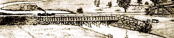
On Saturday, September 29, 2007, the Somerville Historic Preservation Commission, the Middlesex Canal Commission, and the Middlesex Canal Association will sponsor the 5th annual bicycle tour of the historic Middlesex Canal. The Canal was the big dig of the late 18th century. Completed in 1803, after 10 years of construction, the Canal connected the Merrimac River at Middlesex Village (in what is now Lowell) with the Charles River at Sullivan Square in Charlestown. In many ways it served as a model for later canals, including the Erie Canal.
The Canal remained in operation for 50 years, providing both passenger and freight service, but could not compete with the Boston and Lowell Railroad, and subsequent railroads, which began operation in the mid-1830s.
The ride will meet at the Canal plaque at the entrance to the Sullivan Square MBTA station at 9:00am. The entire ride is 38 miles, getting to Lowell in time to catch the 5:00pm train (arriving in Boston 5:43), but people can leave the ride after 20 miles at the Wilmington train station (1:24, arriving in Boston 1:53) or after 28 miles at the North Billerica train station (3:07pm, arriving in Boston 3:43pm). We will make a lunch stop in Woburn; we recommend that you bring a lunch but it will be possible to buy a sandwich there.
The route is pretty flat and level, and since the route includes many stops, we will average 5 miles an hour. The ride will be relatively easy for most cyclists. Along the way we will stop at a number of remnants and restored sections of the Canal, as well as the mansion of Loammi Baldwin, the chief engineer of the Canal, the abutments and piers of the two remaining aqueducts (which carried the Canal over rivers and brooks), and also the Francis Gate lock on the Pawtucket Canal in Lowell. At the North Billerica millpond, we will see the historic mill village and Canal Museum, and the northern end of the floating towpath that carried horses over the millpond.
The ride will be led by Dick Bauer of the Somerville Historic Preservation Commission, Robert Winters of the Middlesex Canal Association, and Bill Kuttner of the Shirley- Eustis House. Steady rain cancels. For more information, contact Dick at <dick DOT bauer AT alum DOT mit DOT edu> (617-628-6320), Robert at robert@middlesexcanal.org, or Bill at <bkuttner AT ctps DOT org>.
46th Annual Old Middlesex Canal Fall Walk
Appalachian Mountain Club - Middlesex Canal Association
Date: Sunday, Oct 14, 2007
Time: 1:30pm
Place: North Billerica
Our fall walk will originate at the Middlesex Canal Museum and Visitor Center in the Faulkner Mill, in North Billerica. The walk will cover the route of the canal south of the mills. Sites will include a lock, the anchors for the floating towpath bridge which once crossed the Concord River Mill Pond, and many stretches of canal, some still watered.
The walk will cover about 3 to 4 miles over generally level wooded terrain and streets in about 2-3 hours, rain or shine.
The Museum and Visitor Center will be open from 12 noon to 4 P.M. Our bookstore will be open as well.
Directions: From Route 3 toward NH, take exit 28, Treble Cove Rd. At end of ramp turn left toward North Billerica. At about 3/4 mile bear left at fork, cross Route 3A (traffic light). Follow the S turn in the road and continue straight (across Pollard St.) onto Talbot Street (passing to the right of St. Andrews Church). As you approach Talbot Mill, bear right onto Old Elm St. and cross the bridge by the dam (becomes Faulkner St.). Park in the lot on the right just east of the bridge. The Middlesex Canal Museum and Visitor center is directly across the street.
For more information: call walk leaders: Bill Gerber 978-251-4971 and Roger Hagopian 781-861-7868
Presidents Message
The past few months have been more than normally eventful. Following several years of effort, MCA members Tom Raphael and Susan Keats completed the work necessary to place the entire Middlesex Canal on the National Registry of Historic Places. This had been done in the 1970s for portions of the canal, but this is the first time that the entire canal route will be so designated.
The application package was turned into the Massachusetts Historical Commission in Sept 2006. Over the winter, abutters were notified and hearings held in the communities along the route (there was only one documented dissenter). MHC is currently adding other period sites to the package and will soon submit the expanded materials to complete the process. We have been working on this for about ten years and it is a great relief to have it completed.
We owe Tom and Susan our deep and enduring appreciation for their great work on this project. They were honored for their work at the Annual Meeting of the MCA, and at a dinner some weeks later.
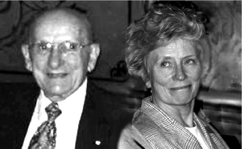
Tom Raphael and Susan Keats (composite photo)
Very sad news -- Doctor Martha Hazen, noted astronomer and long time member of the MCA Board of Directors, and about equally long term editor and publisher of Towpath Topics, passed away just before Christmas last year. Many of the BoD attended a memorial service for her in early January. You will find a tribute to her elsewhere in this issue of Towpath Topics.
In late winter, VP Bill Gerber gave a paper on the Merrimack River canals at the annual Canal History and Technology Conference in Easton, PA. We encourage our members to present historical and technical papers at suitable conferences.
The Annual Meeting of the MCA was held on April 28th. An election of MCA officers was held, with all incumbents agreeing to serve for another year. A listing of the officers and directors can be found on our web site. However, Shayne Reardon, one of our very active and exceptionally productive board members, submitted her resignation, effective the end of the summer, due to family health problems. I dread her impending departure, she will be sorely missed.
The speaker at the Annual Meeting was vice-president, Bill Gerber; the lead-in portion of his talk can be found elsewhere in this issue of Towpath Topics. The remainder of the talk consisted of a consolidation and update of information on the Merrimack River Canals.
At the end of the meeting, my wife, Joan, presented me with a surprise birthday cake in honor of my eightieth. Im now, easily, the longest serving President of the Middlesex Canal Association.
Other news: Tom Dahill has been working on an upgrade to the childrens corner of the canal museum -- Rob Winters has been doing a fine job of keeping up our web site; check it out at http://www.middlesexcanal.org. -- Tom Raphael has made considerable progress toward acquiring the Concord River Mill Pond, and some of the surrounding land and structures for the future construction of a park - commemorating the canals Concord Crossing. He has also identified other canal related properties for publicly accessible parks and greenways, and to define the improvements needed at the various parcels. -- Jean Potter, Tom Dahill, Debby Fox and Betty Bigwood (our Education subcommittee) have compiled a manual for elementary schools to use to teach the history of the Middlesex Canal. -- Jean Potter and Betty Bigwood served on the nominating committee for the annual meeting and were pleased that (as noted above) all members but one agreed to serve again.
In recent years, there have been a number of departures from the MCA Board of Directors. Several of these positions remain unfilled. If you would be willing to serve on the board, please contact our membership chairman, Neil Devins. We do need new blood, with new ideas, to fill our ranks.
The above should bring you up to date on most of the activities completed or underway, and at least one of our current needs.
Nolan Jones, President, 603-672-7051
MCA Fall Meeting
Date: Sunday, Nov. 4
Time: 2:00pm
Place: Middlesex Canal Museum, Faulkner Mill, North Billerica
The Fall meeting of the Middlesex Canal Association will feature Aurore Eaton, speaking about the life of Samuel Blodget. Blodget was the first to build a canal to bypass Amoskeag Falls at Derryfield (later Manchester) New Hampshire. This talk will celebrate the colorful life of Samuel Blodget (1724-1807), merchant, lumberman, inventor, and visionary.
Blodgets life was filled with schemes and drama, with great successes and spectacular failures. To honor Blodget, his fellow citizens of Derryfield changed the name of the town to Manchester (after the great industrial city of Manchester, England), as he had prophesied that the water power of Amoskeag Falls would someday lead to large-scale industrial development in the area. Blodget didnt live long enough to see his prediction come true. His transportation canal eventually became part of the Amoskeag Manufacturing Company power system, and Manchester grew into one of the most extensive and prosperous mill cities in New England. Ms. Eaton is the Public Program Coordinator for the Manchester (NH) Historic Association.
Calendar of Events
Saturday, Sept 29 - Bicycle Tour of Historic Middlesex Canal
Sunday, Oct 14 - Joint AMC-MCA Fall Canal Walk.
Saturday, Oct 20 - Rededication of the Baldwin Monument, and Tour
Sunday, Nov 4 - MCA Fall Meeting
First Wednesday of the Month - Board of Directors Meeting, 3:30 to 5:30pm
(2007: Sept 5, Oct 3, Nov 7, Dec 5; 2008: Jan 2, Feb 6, Mar 5, Apr 2, May 7)
Members Welcome
 A Tribute to Martha Hazen
by Betty Bigwood
On 23 December 2006, Dr. Martha Hazen McHenry passed away of leukemia. A memorial service was held for her at the Linden Ponds retirement community in early January.
Martha was a long time Director of the Middlesex Canal Association and, for 12 years, Editor of our biennial publication, Towpath Topics. She liked a well run meeting and every fall she promptly appeared with calendar in hand to organize meeting and event dates for the entire year. For many years, prior to acquiring our museum space, she had welcoming meetings in her home in Belmont, where her living room always seemed to expand to hold another guest.
Marthas professional career revolved around astronomy. She was recently honored by having an asteroid named after her number 10,024. The Boston Globe published a marvelous tribute to her life; see our website www.middlesexcanal.org for a reprint of the story.
Martha was also a quilter, and an unusual one at that. She loved to construct multicolored quilted vests which were very pleasing and very well made. And she loved to travel; the decor of her home revealed her eclectic tastes and her love of far away places.
Her later life changed for the better upon meeting sole mate, Bruce McHenry. Their life involved weekends at Bruces home on the Cape and hers in Belmont. When Bruces cardiac condition worsened she rose to the call and learned to construct low fat meals without salt or sugar. When the two houses became a bit too much, they folded shop and moved into Linden Ponds retirement community, on the south shore, and were very happy there.
Martha has two children and five grandchildren from a previous marriage.
Considering our Boards longevity, to end ones life at 75 seems far too short. She had such energy and so much more to see and give. We miss her very much.
Spring 2007 Canal Walk Report
by Roger Hagopian and Bill Gerber
As usual, our Spring event was a joint enterprise with the Appalachian Mountain Club. At the last moment, due to heavy rain and impassable vegetation that wed not had time to clear, we changed the intended direction of our walk. Instead of heading south from the Middlesex Canal Museum and Visitor Center, we elected to walk part of the Lowell section (north branch) of the Middlesex Canal, from the Mill Pond in North Billerica to Riverneck Road in Chelmsford.
Normally this is a delightful section of the old canal. It proceeds in a nearly straight line along roads, through wooded areas, and across a swampy area. (This latter stretch should also be attractive to birdwatchers.) Both the towpath and the canal are readily recognizable for most of the way, and pauses can be made to show off the anchor stone for the floating towpath (on the western shore of the Concord River), the entrance gate segment of the western Guard Lock (within the iron fence by Talbot Mill), and the remains of Oak Lock together with its turning basin (by the North Billerica Fire Station). The walk is easy and requires very little trail clearing or other preparation.
Due to the high level of the Concord River at the millpond, the anchor stone and rings of the floating towpath were submerged, so our group of about four dozen explorers headed over to the guard lock located within the Talbot millyard. Rob Winters noticed that one of the capstones of the inlet channel was precariously out of place, with the attached iron railing now keeping it from falling into the channel. This lock is all that remains of the 20 locks which once raised and lower boats traveling along the canal.
The shaped stone and iron rings, which held the hinge posts of the wooden gates, are still in place. The mill likely used the canal as a source of water and so this lock and section of the canal remained intact long after the demise of the Middlesex Canal.
Continuing our walk along the perimeter of the Talbot Mill, we arrived at the site of the Red Lock where a basin enabled boats to turn 90 degrees onto a channel leading to the lock and the Concord River. This was part of a late response to the Legislatures requirement for the Middlesex Canal Company to make the Concord River navigable.
From here, boats could travel around the Mill Dam to and from Lowell below the Pawtucket Falls on the Merrimack River; whereas boats on the Middlesex Canal arrived above the falls on their way to and from Nashua, Manchester and Concord, New Hampshire.
Walking along Lowell St. toward Boston Rd., Route 3A, we traced the route of the adjacent canal which has been landscaped by the Billerica Section of the Middlesex Canal Commission. From here to Brick Kiln Rd. the canal passes through a woodland.
Beyond, to Riverneck Rd. in Chelmsford, the canal passes through wetlands where it now merges with large and small ponds, some natural and others created by the damming of swampland water by Route 3 and Lowell Connector construction.
It was in this area, long before we got to Riverneck Road, that we encountered a very large puddle; which called out to us, About face! And so we retraced our steps back to the museum and called it a day.
Middlesex Canal Ox Bow
by Howard B. Winkler, Treasurer
The Ox Bow, shown in the figure, is located in the Wilmington Town Forest. It was the result of the canal builders inability to form a stable embankment through the swamp at Maple Meadow Brook. Directions to the Ox Bow can be found in Burt VerPlancks Middlesex Canal Guide and Maps, an Association publication.
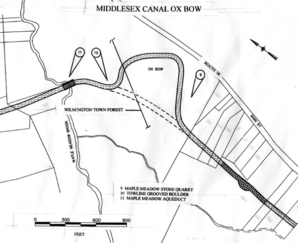
Background of the problem at the Wilmington swamp that resulted in the construction of the ox bow is found in Roberts, p.112 where he writes, At the annual October meeting during these years the directors were compelled to come before the proprietors with a skillfully worded apology. Sullivans efforts in this connection were frank, disarming and able. He noted in 1802 the great impatience among the proprietors, their long sufferance under the burden of assessments, but urged them to consider the magnitude of the work. and then quotes Sullivan.
This we can say with certainty, that from the most careful inquiry the Directors have been able to make, they are convinced, that the same quantity of work, in the business of canalling, has never been done in Europe, in less time, or at a less expense. . . .
One or two ledges, concealed by great depths of earth have been revealed by the spade, and one or two morasses have disappointed calculations formed from the most assiduous experiments within the reach of human power. These have called for great quantities of labour, and retarded the accomplishment of the proprietors wishes. . . .
Since the annual meeting of last year, the ledge in what is called Rogers ground near Concord river has been obliged to yield to the Canal. The sinking morasses at Lubbers Brook and in Carters field near Woburn meeting house have been rendered competent to bear the weight of the canal banks thrown on them. The banks, which appeared to be unable to retain the water, have become more consolidated and firm, so that they afford a certainty that no permanent injury will ultimately result from their leaking.
The morass [swamp] at Maple Meadow Brook was not capable of being rendered competent so the canal builders went around. The figure shows the possible path if an embankment was constructed through the swamp. The path through would have shortened the overall length of the canal by about 263 yards or about one-half of one percent. The cost for the additional length was probably greatly outweighed by the cost of the failed attempts to build a stable embankment.
The figure was created by splicing two maps taken from the Middlesex Canal Heritage Corridor, prepared for The Middlesex Canal Commission by the Waterfield Design Group Inc. Tom Raphael directed the effort to create a modern map of the canal. He is a Middlesex Canal Association Director and Middlesex Canal Commissioner, and is leading the effort to have the entire length of the canal, placed on the National Register of Historic Places.
The paving stone pattern shown in the trace of the canal indicates an existing or partial prism, and the herringbone pattern indicates the prism was built over.
Baldwin Family Papers at the Winterthur Museum Library, Kennet Sq., DE
as reported by Bill Gerber
Abstract: Baldwin family. Papers. 17841904, bulk 182034; 14 vols. 36 loose items: ill. (some col.)
The Baldwins were civil engineers from Woburn, Massachusetts. Loammi Baldwin began his career during the late eighteenth century and in 1804 oversaw the construction of the Middlesex Canal in Massachusetts. Three of his sons Loammi Jr., James Fowle, and George Rumford followed his chosen career. Loammi Jr. graduated from Harvard and began his professional life as an attorney. Finding the law distasteful, he turned to civil engineering. James Fowle pursued a career as a merchant before he became an engineer. He would eventually work for railroads and undertake a study of the quality of the water supply in Boston. George Rumford designed and built the Boston Marine Railway and consulted on the construction of waterworks in Charleston, Massachusetts, and Quebec, Canada.
Collection materials reflect the professional lives of the Baldwins as civil engineers. Projects mentioned in the papers include the Middlesex Canal, the Charles River Bridge, the Charlestown Naval Dry Docks, the upgrading of Bostons water supply, coal mining, canal construction in general, and soundings in Boston harbor. Illustrative material is chiefly in the hand of George Rumford Baldwin. Working in pen, watercolor, pencil, and wash, George Rumfords sketchbooks depict railroads, dams, canals, locks, waterworks, bridges, and buildings. Of particular importance are his drawings of wooden framing patterns.
Among the items, there is a hand-written, multi-page listing of many of the small construction contracts that were let to build the canal inside the front cover of a History of the Middlesex Canal. This History, part of the Baldwin Family Papers, is actually a hand-written ledger of the rationale behind major decisions and actions taken, under the supervision of Baldwin and the Proprietors, during the planning and construction phases of the canal. (Ive not seen anything comparable in the MCCs corporate records, or in materials at Harvard, Mass Historical Society or Peabody-Essex.)
The curator of that section at Winterthur, Mr. McKinstry, indicated that he would be willing to provide a copy of this document to the Middlesex Canal Association for the price of copying and shipping the (actually used/written on) pages - $0.50 per page. (My guess is that this will total to around $50.) I suggest that we obtain a copy and put it with the MCC records at Mogan Center. (Or ask for two copies and keep one at the museum.)
The collection also contains two books of George Rumford Baldwins sketches, which include such things as notes on the dimensions of the Brooks Bridge and a detailed sketch of the Medford Aqueduct, some of which are in color. Ive obtained xerox copies of those sketches that relate to the Middlesex, but I suggest that we consider asking for copies of the sketch books too.
Baldwin Green Restoration Project
City of Woburn - Summer/Fall 2007
Baldwin Green at the intersection of Elm Street and Main Street honors Colonel Loammi Baldwin, a famous Woburnite who contributed to our nations prosperity as a patriot leader and a visionary engineer. The purpose of this project is to repair and preserve the monuments, to increase their visibility and to beautify the surrounding landscaping. It is a collaborative effort involving Mayor McLaughlin, city officials, the Woburn Historic Society, and local businesses.
Scope of Work:
The Green showcases two historic monuments: a life size, bronze statue of Colonel Baldwin erected in 1917 and a historic cannon. Both monuments will be restored by Skylight Studios. Landscaping will be provided by Down to Earth Landscapers. Soot and acid rain are causing damage to the Baldwin monument. The surface will be fully refinished, protecting the original patina, to restore the full luster of the bronze.
Baldwins sword was vandalized years ago. A new one will be reproduced in bronze and securely attached. The granite base and its bronze plaques will be cleaned. The cannon will be cleaned, painted and sealed. Trees and shrubs obscuring the view of the monuments will be removed. Ground level lighting will be installed to illuminate the Baldwin Monument at night. New perennials, annuals, and grass will refresh the green.
Rededication of Baldwin Green:
October 20, 2007 marks the 200th anniversary of Colonel Baldwins death. The Rededication ceremony will be on Saturday, October 20th at 10:00 a.m., followed by a reenactment/graveyard tour of the First Burial Ground on Park Street at 1:00. Both events are free to the public, but the graveyard tour requires tickets. The Historical Society can be reached at 781 937-8848 or online at www.woburnhistoricalsociety.com to acquire tickets for the tour.
A Brief History of Colonel Baldwin (1745-1807)
Colonel Loammi Baldwin was a noted American engineer, politician, and a soldier in the American Revolutionary War. Baldwin is known as the Father of American Civil Engineering. He surveyed and was responsible for the construction of the Middlesex Canal; but today he is perhaps best remembered for the Baldwin apple which he developed at his farm.
Baldwin attended grammar school in Woburn, Massachusetts. Later he would walk from North Woburn to Cambridge with his younger friend and neighbor, Benjamin Thompson, later Count Rumford, to attend the lectures at Harvard College. When back at home, he and Thompson would then perform their own experiments. Baldwin received a Master of Arts degree from Harvard in 1785.
In 1774 Baldwin enlisted in a regiment, and commanded the Woburn militia at the Battle of Lexington and Concord as a major. At the beginning of the war he enlisted in the 26th Continental Regiment commanded by Colonel Samuel Gerrish. Here he advanced to colonel upon Gerrishs death. Till the end of 1775, Colonel Baldwin and his men remained near Boston, but in April 1776, he was ordered with his command to New York City. Later, on that memorable night of December 25, 1776, in the face of a violent and extremely cold storm of snow and wind and hail, General Washington and his army crossed the Delaware to the New Jersey side, and fought the Battle of Trenton. Baldwin and his regiment participated in the crossings, the two battles of Trenton, and the subsequent battle of Princeton.
In 1777, Baldwin resigned from the army because of ill health. He was subsequently elected to various public offices between 1780 and 1796. He was appointed High Sheriff of Middlesex County in 1780. From 1778 - 1984, he represented Woburn in the Massachusetts General Court. Baldwin was a member of the American Academy of Arts and Sciences, contributing two papers. His fine mansion still exists in Woburn.
Project Funding:
The restoration project is being funded through the donations of local business and private citizens. Recognition of contributors will be made during the re-dedication ceremony with the following Levels of Recognition:
Minutemen: $1,000.00 - or more
Compatriots: $500.00 - $999.00
Friends: $100.00 - $499.00
Please consider a contribution to this worthy, historic renovation.
For more information about the restoration project please contact: John Ciriello, Alderman, Ward 6; Woburn Common Committee.
Transportation Canals of Eastern Mass. and South Central NH
A Different Perspective
by Bill Gerber
It is well known that New England was in the forefront of Americas industrial revolution, which by the mid-1820s was centered in East Chelmsford (which later became the city of Lowell) and focused on the production of textiles. But few seem to realize that, three decades earlier, this same area was in the vanguard of a transportation revolution brought about by the construction of canals. Furthermore, the ready availability of a good transportation system, able to carry heavy loads, clearly contributed to the success of the subsequent industrial and commercial enterprises.
The success of this system inspired other states to proceed with their canals; notable among them, the Erie Canal, subsequently completed by the State of New York.
By 1815, more than 120 miles of canals and navigable waterways had been opened up throughout eastern Massachusetts and south-central New Hampshire. This network rendered the Merrimack River navigable from Concord NH to tidewater, near Haverhill MA, and linked the Merrimack with the Charles River, in Charlestown MA; which river itself became part of the network. Additional canals, made accessible by the Charles, were built in East Cambridge and Cambridgeport, across Boston through Haymarket Square into Boston Harbor. A branch canal was constructed from the Middlesex to the Mystic River in Medford; and another from the Merrimack up into Piscataquog Village in NH. There appear to have been still additional short industrial canals This network transported timber and wood products to build ships and homes, and for export; carried the stone and bricks to build the later mills, and also the raw materials used by the mills and the finished textiles produced by them. During its productive years, the canal network was overlaid by more than two dozen Landings located in most of the en route communities. These were publicly accessible cargo transfer points, consisting of a dock and warehousing space, which facilitated the exchange of all conceivable items of merchandise. Eventually, the network carried the materials of its own demise - rails and ties for the construction of railroads, and even the parts of a disassembled steam locomotive purchased from England.
The model by which the network was built was unusual. Unlike other locations, where canals were usually constructed either by the state or by major industrial firms, the MA/ NH network was completed by a dozen private, independently financed companies, each of which, collaboratively (though perhaps not deliberately so), took on a piece of the effort. Clearly, the Middlesex Canal accomplished the largest portion, but other significant portions were undertaken by those who built the Pawtucket and Amoskeag Canals, Bow and Hooksett Canals, the canals of East Cambridge and Cambridgeport, and the seven canals between Derryfield (later Manchester) and south Merrimack.
Following are some of the highlights in the development of this transportation network:
In 1792, The Proprietors of Locks and Canals on Merrimack River (PLC/M) was incorporated by the Massachusetts legislature. Their charter was to make the Merrimack navigable for boats, rafts and masts, from the New Hampshire border to tidewater . To fulfill the charter, the PLC/M built the Pawtucket Canal, improved seven other rapids (Wicasee, Hunts, Varnums, Parkers, Peters, Bodwells and Mitchells), and opened for traffic in 1797.
In 1793, the Middlesex Canal Company was incorporated to link the Mystic River, in Medford, to the Merrimack River above Pawtucket Falls. Before construction began, the southern end was changed to Charlestown. The MCC surveyed two routes for the canal in the summer of 1794, began construction in 1796 and opened their canal to through-traffic in early 1804.
In 1794, the Isle of Hooksett Canal Company was incorporated by the New Hampshire legislature to construct a canal around falls of the same name on the Merrimack River. This effort was completed in 1811.
Also in 1794, Judge Samuel Blodget was authorized to construct a canal to bypass Amoskeag Falls, a 45+ foot drop in the Merrimack River, at Derryfield NH (now Manchester). When opened in 1807, Blodgets canal may have consisted of nine locks in a mile long channel built partly in the east bank and partly in the river.
In 1805, Medford MA area shipbuilders formed a company to build a branch canal to link the Middlesex with the Mystic River. This two lock canal logged its first tolls in 1807. (Timber from New Hampshire contributed significantly to the construction of over 400 Medford built ocean-going sailing vessels during the years that the canal operated.)
In 1808, The Union Locks and Canal Company was incorporated in New Hampshire to make the Merrimack River navigable between Reeds Ferry and Amoskeag Falls. This company constructed six canals around discreet falls and rapids within this stretch of river. At least three of these canals were completed by late 1811 and the remainder by late 1813.
Also in 1808, The Bow Canal Company was incorporated in New Hampshire to render both Turkey and Garvins Falls navigable. This firm constructed the Bow Canal to bypass Garvins Falls. They built their dam high enough to flood out Turkey Falls, a mile upstream, through which channels were cleared. Bow Canal opened for traffic in 1812.
In 1809, three companies (i.e., the Middlesex Canal, Lechmere Point and the Newburyport Turnpike Companies) united to construct a bridge across the Charles River, from Leverett Street in Boston to Lechmere Point in East Cambridge. Towpaths may have been built along the sides of this bridge.
Also in 1809, the floating towpath, where the Middlesex Canal crossed the Concord River, was enlarged so that tow animals could draw their tow directly across the river. At the same time, additional gates were added to the guard locks there, so that bands of log rafts could be drawn across the river without requiring disassembly.
In 1810, the Boston Mill Pond Company constructed a canal from the Charles River into Haymarket Square. This connected with an enlarged natural waterway to connect with Boston Harbor.
At about that same time, the Lechmere Point Corporation began work on several canals in East Cambridge. These became known as the Broad, South, Portland (aka North) and Lechmere Canals. Together with the Millers River, and through the Middlesex Canal, they linked East Cambridge and Cambridgeport to the Merrimack Valley.
In 1811, the Middlesex Canal Company improved four rapids on the Merrimack River to facilitate safe passage. (Ascending the river, these were Wicasee, Taylors, Hills Crossing and Cromwells Falls.)
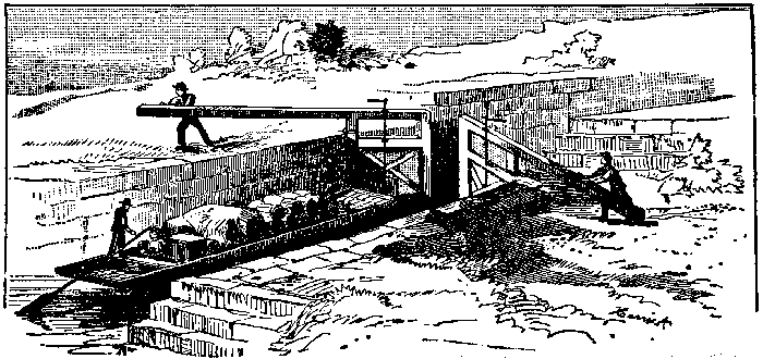
Also in 1811, John Langdon Sullivan (Agent for the Middlesex Canal Company since his appointment in 1808), established the Merrimack Boating Company. The MBC became the principal shipping company on the canal. (it was succeeded by the Boston and Concord Boating Company in 1823.)
In 1812, Sullivan, launched his first successful steam tow boat (his third design), which, thereafter, operated on the Merrimack River (where it was impractical to build towpaths). During initial trials on the Charles River, with its 20 hp Oliver Evans steam engine, this boat traveled 7 miles and six furlongs in one hour (i.e., 7-3/4 mph, for an hour). Normally driven by chain-floats drives on either side of the boat, it also featured a warping windlass, to which the power of the steam engine could be directed. This was used to warp the boat up rapids, probably the four improved in 1811.
Also in 1812, through the efforts of J. L. Sullivan, the New Hampshire legislature incorporated the Proprietors of Locks at Cromwells Falls. Management of this endeavor was transferred to the Union Canal Company the following year. This canal opened for traffic in 1815.
In 1813, the Massachusetts legislature authorized the Middlesex Canal Company to construct a canal around Wicasee Falls. This too was completed by 1815.
In April 1814 , following favorable resolution of a dispute with Robert Fulton, J. L. Sullivan was awarded a patent for a Steam Towboat with Warping Windlass, the first towboat patent ever issued in the USA, and the first of sixteen awarded to him over the next few years.
Thus by 1815, there were more than 120 miles of canals and navigable rivers in commercial and industrial use in eastern Massachusetts and through south central New Hampshire, with traffic facilitated by at least one steam powered towboat.
In 1816, J. L. Sullivan launched an improved version of his steam towboat, and two more patents were awarded to him the following year.
In 1817, New York sent a contingent to examine the MA/NH canal system; and on July 4th of that year, in Rome, that State began construction of the Erie Canal; first passage through the length of which was made in October, 1825.
Response to a Proposed Canal Engineer Survey Techniques Field Workshop
By Bill Gerber and Ryn Agnew
The idea of holding a field day to reconstruct the survey techniques used by early canal engineers was proposed in a recent issue of Canal Currents (CC), the newsletter of the Pennsylvania Canal Society (PCS). I (Bill) responded positively to the idea, and contributed a little background based upon what I know about how the Middlesex Canal was surveyed, and the very significant advance in the surveyors art that resulted, in this country, from that action.
Ryn asked to publish my response and this resulted in a collaborative article for the next CC. The thought occurred that such a workshop might also be of interest to MCA members, and so she agreed that I should offer the article to Towpath Topics readers as well. As of this time, no date has been set for the surveying workshop. The article follows.
In August, 1794, over a two to three week period, two different routes were surveyed for the Middlesex Canal by Loammi Baldwin and his sons under the guidance of William Weston, an English canal engineer. This action introduced a significant improvement to the state of the surveyors art in New England (and perhaps just a bit earlier in PA because of the chronology of Wm. Westons travels). This may have been the first time that accurate elevation measurements were made along an extended route of survey in North America.
Subsequently, the westernmost of the two surveyed routes was selected for the route of the Middlesex Canal. Forty years later, when the Boston and Lowell Railroad was built, the survey for the easternmost of the two routes was used.
Weston had been persuaded to come to the USA by Robert Morris (Financier of the American Revolution) to supervise construction of two canals in the Philadelphia area; the Schuylkill and Union canals. Dissatisfied with the earlier surveys that had been made, the Proprietors of the Middlesex Canal borrowed Weston for the cited period. (It may be that the only reason he agreed to come was that his wife wanted to meet and mingle with Boston society!) Baldwin had been designated Supervisor of Construction for the Middlesex Canal. His sons followed in his footsteps to become surveyors and engineers for many New England and nearby construction efforts.
The surveying improvement was made possible by the introduction of the Y-level (sometimes referred to a the Wye-level), an instrument that was a precursor to the surveyors transit, and the station (vertical measuring) rod. Weston brought several of these instruments with him from England, which had been fabricated by Troughton, of London. Initially the Middlesex company borrowed one instrument from Weston, but then persuaded Weston to come to Boston to oversee a survey. James Sullivan, principal promoter of the Middlesex Canal (and later governor of Massachusetts), subsequently purchased two such instruments from Troughton for use by the Middlesex Canal Company.
What difference did the Y-level make? In an 1793 survey of potential routes for the Middlesex by Samuel Thompson, it was estimated that, at the intended head of the Middlesex, the Merrimack River was about 16 above the level of the Concord River at the point where the canal would cross that river. The Weston-Baldwin survey later determined that the Merrimack was 24 below the level of the Concord; thus the difference between the two surveys represented an elevation error of about 40 in a distance of about 6 miles.
It appears that this amount of error was not unusual. Around the corner from the Middlesex, when water was first let into the Pawtucket Canal, it was found that the level of the channel bottom of that canal at the first locks (probably at the location of Swamp Locks) was the same as the surface level of the river at the inlet to the canal.
This would have amounted to an error of three or four feet in about a mile. This might have been the reason why, in the fall of 1794, the Proprietors of Locks and Canals on Merrimack persuaded Loammi Baldwin to lead a survey of six lesser rapids downstream of the Pawtucket Canal. Baldwin was about the only person in New England who knew how to do accurate elevation measurements.
Although Weston continued to assist Baldwin by providing structural designs and casting models for key canal parts, Bill is convinced that Loammi Baldwin has a legitimate claim to being the first American born, domestically educated civil engineer.
Similarly, his son, Loammi II, has a defendable documented claim to the title of Father of American Civil Engineering. Other researchers have afforded those credits to different individuals.
If possible, additional aspects of the Field Workshop that would be of great interest would be to differentiate the surveying art, and the instruments used, pre- and post- Y-level?
It would also be interesting to identify and include the instruments and techniques were used on various other early canals. (E.g., such as the Patowmac Canal in VA, the Cooper and Santee in SC, the inclined plane at South Hadley, MA, etc.)
-- Ryn and Bob, 570-538-3206 & Bill, <bill_gerber AT bostonbbs DOT org>
Tribute to Shayne Reardon
by Tom Dahill for the Committee on the Museum
One person has been involved with the functions of the museum from the spackling of panels for exhibitions to full organization of the office, and the personnel who contribute time and energies, as they will, to the successful operation of the organization. Shayne Reardon has been in place as the requirements of the museum have grown and has, with calm intelligent application of her talents directed the operation with the skill of a Diplomat and the oversight of a Prime Minister. As a result, visitors to the museum are filled with spontaneous praise for its appearance. There are always words of surprise when they wander through the exhibits and realize the intent of the displays.
Shayne Reardon has developed the office, the computer files, maintenance schedules, rentals from external patrons, coordinated docents and contributed her time to that activity, and just recently repaired a bare area in the exhibits by expanding a crowded display with the ease of a professional graphic designer. Quietly she has directed the museum, with modest dignity, in the direction long planned by decades of members of the Middlesex Canal Association: Exposition and Education of the Heritage of the great engineering endeavor. The existence of a fully volunteer museum is an anomaly and depends upon the unselfish determination of individuals. To have a person of great abilities of organization is rare. Shayne Reardon is both of these. We will miss her.
The Middlesex Canal Endowment Fund
Helping to Make our Vision a Reality
by Alan Seaburg
Your Board of Directors in October 2006 elected to use the memorial gifts given to the MCA to honor the long-time work of Fran and Burt VerPlanck as the founding gift for an Endowment Fund. To this start up source the fund has received several sizable gifts from members committed to helping the effort of the Association succeed. In addition, the general membership gave in the December annual appeal letter over $1,000 and the Board at its March meeting transferred $3,000 from the general account into the Fund. It stands today at about $15,000 which has been invested in the Fidelity Balanced Fund - FBALX - whose goal is to generate income and capital growth consistent with reasonable risk. We hope to raise at least $500,000 for the Fund - the interest on which will go to support our activities.
We hope too that all our members when they can will make additional gifts to the Endowment Fund and consider putting in their Wills a legacy to the MCA. We hope further that our members will encourage their friends, neighbors - and where possible business and social organizations - to make contributions to the Fund in support of canal projects. For gifts to create the bikeways, the walkways along restored areas of the canal, to expand our Middlesex Canal Museum and Visitors Center, and to realize the creation of a Heritage Park are really gifts to future generations of children, families, adults and senior citizens.
When the Middlesex Canal Association was formed in 1962 with Arthur L. Eno, Jr. as its first president, its mission was to recognize and preserve the Middlesex Canal for public, educational, and recreation use. That is still our Mission today. The purpose of our newly created Endowment Fund is to help make that vision a reality - today, tomorrow and tomorrow and tomorrow.
Over the decades the basic working capital of the Association has come from dues and occasional gifts. These support our members newsletter, Towpath Topics, our three public meetings a year that feature talks on a canal topic usually with slides, and our very popular spring and autumn walks along sections of the old Middlesex Canal.
Early on, however, the Association also began to secure canal land and to gather and care for canal artifacts and documents. To accomplish this latter responsibility a working relationship was created with the Patrick J. Mogan Cultural Center in Lowell.
Then, in the late 1970s, Leonard Harmon and others provided the leadership that resulted in the creation of the Middlesex Canal Commission - a mix of state officials, regional agencies and appointed members from canal towns/cities. Its objective is to restore awareness and public use of the canal property to the extent feasible under prevailing conditions. One way to do this was to create bikeways, walkways, and hiking trails along the old canal route and to establish a Middlesex Canal Heritage Park at the Concord mill pond site in North Billerica. Inadequate funding made it impossible to achieve quickly all these goals.
Today the Middlesex Canal Commission under the thoughtful and able leadership of Thomas Raphael, the right successor to Leonard Harmon, is moving ahead again to return the canal to public use. It has two contractors actively surveying all the extant segments of the canal for possible degrees of restoration and inclusion into a heritage corridor.
There are resources for the restorations but there are many problems of ownership, permission and permitting before actual restorations can be made. What we restore, we must maintain.
One of our MCAs most significant projects is the Middlesex Canal Museum and Visitors Center at Faulkner Mills, Billerica. The Museum is run by our Museum Committee with the wonderful support of the Middlesex Canal Commission and the enthusiasm of the Billerica Section of the Commission. The Museum is open on weekends from April to September and on other special occasions. Volunteer docents are on duty to help explain the canals history to visitors. Its exhibits are in the process of development and include from time to time special shows.
Our MCA Education Committee has over the last few years developed teacher research guides and other resources and in the spring works with - right now - schools in Wilmington and Billerica where students learn about the canal and spend a day visiting the Museum.
As our work and tasks have expanded to meet the lofty goals of our Mission it has become necessary to make plans for additional reliable financial resources. One of these is the newly created permanent MCA Endowment Fund. We hope, therefore, that all of us will want to be a part of a better Tomorrow and tomorrow and tomorrow.
Editors note: This issue of Towpath Topics was edited by Bill Gerber with production assistance by Robert Winters.
A current Calendar of Events is available at our website: www.middlesexcanal.org