
Middlesex Canal Association P.O. Box 333 Billerica, Massachusetts 01821
www.middlesexcanal.org
| Volume 50 No. 1 | September 2011 |
MCA ACTIVITIES
Please mark your calendars. The Fall Bicycle Ride, along most of the length of the Middlesex Canal, or optionally a part of it, will be held on Saturday, Oct. 1, 2011. The return, for most including those who depart early, will be via the Lowell commuter train back to Boston.
During October there will be special exhibits at the Middlesex Canal Museum coincident with Massachusetts’ Archeology Month.
The joint MCA-AMC Fall Walk will take place on Oct 16, 2011 in the Winchester/Medford area. Included in the agenda is a visit to the site of the Mystic River aqueduct in Medford, about which see Tom Raphael’s article, beginning on page 13 in this issue, detailing the circa 1827 upgrade of the structure.
Our Fall Meeting will be held at the museum on Sunday, Nov 6th, beginning at 2:30 PM. Jeff Ellis will recount his participation in this year’s 13th running of Cycling the Erie Canal. This tour began in Buffalo, NY and ended 8-days later in Albany; two-thirds taking place on the completed portion of the Canalway Trail System.
See the Calendar, following, for more information on our activities. Also included in the calendar are meetings and tours sponsored by other organizations, in which you may want to participate.
Please also check our web site periodically, at the URL noted above, which often lists canal-related events and topics of potential interest.
PRESIDENT’S MESSAGE
by J. Jeremiah Breen, jj@middlesexcanal.org
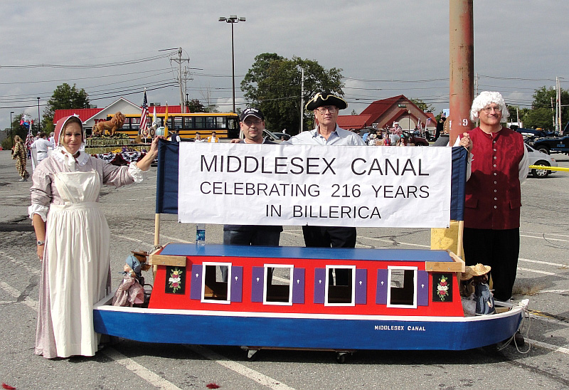
The Middlesex Canal Association needs more members and volunteers. Following the appeal in September 2010’s Towpath Topics, Russ Silva, a proprietor, walked into the museum the weekend of September 11th announcing ~ “I’m here to volunteer." The next Saturday he brought his father’s tricorn to the museum at 8 am, changed his clothes for those of a colonial, including a George Washington wig, and walked in Billerica’s Yankee Doodle parade handing out invitations to our museum. His picture is at http://middlesexcanal.org/images/YD800x600.jpg. Russ is the colonial at Celerity’s bow. The Canal needs more such volunteers.
Russ was elected a director of the Middlesex Canal Association February 13th at a meeting of the directors, held around the kitchen table in the museum prior to the Winter Meeting. After the vote, he was welcomed to the Board with spontaneous, joyful applause. The directors are really glad to have Russ pitch in with us. He was elected corresponding secretary by the proprietors at the May 1st annual meeting.
A volunteer is needed to research land titles at the Shawsheen Aqueduct. Once ownership of the land and its extent are defined, the plans for a park on the Shawsheen River centered on the aqueduct and part of both Billerica and Wilmington can proceed. Money is available from the 18.4-cent-a-gallon federal gas tax to build the park as a “transportation enhancement."
Our First Decade - The Middlesex Canal Museum and Visitor Center opened its doors in the Faulkner Mill the first week in July 2001 – just a few weeks before 9/11. An enormous effort by dedicated volunteers from the Billerica section of the Middlesex Canal Commission – such as Marian Potter, Shayne and John Reardon, Donna Doucette, and Karen Carpenito – and many others will be long remembered. In July 2011 we celebrated the start of our second decade with chocolate cake and ice cream.
“This Place Matters" is a presidential goal. Prior president Bill Gerber forwarded to the directors an email from a finalist in the 2011 This Place Matters Community Challenge: “… out of 265 entrants we were selected to compete! It’s a great honor to be among the 100 finalists across the country competing for cash prizes of $25,000, $10,000 and $5,000. Now we need your help! The cash prizes will be awarded to the organizations that rally the most supporters." The Middlesex Canal matters, and with supporters from Boston to Lowell, and the American Canal Society, we can win. The 2009 contest was won by a gas station with 7,000 votes (http://tinyurl.com/2009finalists). The 2011 contest with 80,000 total email votes cast was won by the Breakers of Newport RI. Now is the time to prepare supporters of the Middlesex for next year’s contest.
Leggett & Platt, Inc., a former owner of the Talbot Mill, has donated the land it owns between the Concord River dam and Pollard St to the Middlesex Canal Commission. This gift is due to the esteem Leggett’s representatives have for Tom Raphael, chairman of the Commission’s executive committee. With the land previously obtained by the Billerica Historical Society, most of the east bank and much of the west bank are now available for the Middlesex Canal Park.
J. Jeremiah Breen
TABLE OF CONTENTS
MCA Activities
President’s Message (Breen)
Calendar of Events
Remembering Two “Pillars" of the Middlesex Canal Association
Wilbar Hoxie
D. Bruce McHenry
Five Weeks at the West End Museum (Bigwood)
Towpath Topics Archive (Winters)
Symmes River Aqueduct (Raphael)
Extracts from Thoreau (Winkler)
Colonial Currency (Raphael)
Plans ... to restore local waterway (Bowen & Harrington-Davis)
Officers & Directors 2011-2012
Miscellany
CALENDAR OF EVENTS
Middlesex Canal Association (MCA) and related organizations
First Wednesday - MCA Board of Directors’ Meetings - Members and the public are invited to attend. The Board meets the first Wednesday of every month (except July and August), at the Museum, from 3:30 to 5:30pm.
Sept 19-24, 2011 – World Canals Conference in the Netherlands: provinces of Gronigen, Friesland, Drenthe, and Overijssel. More information at www.worldcanalsconference.org.
Sept 23-25, 2011 - Canal Society of Indiana fall trip, “Once on the Blue Moon," a six-hour cruise on the Tennessee River at Chattanooga, TN, passing through locks; Civil War Dinner Theater at Buttonwillow Church at Whitwell, TN; time for touring battlefields, museums, aquarium, etc. on your own. For info: indcanal@aol.com.
October, 2011 - Special Exhibits - Massachusetts Archeology Month
The Great Billerica Dam Controversy is the focus of the Report of the joint special committee upon the subject of the flowage of meadows on Concord and Sudbury Rivers, 1860, 370 pages. The title of the exhibit is taken from the 1982 Towpath Topics article, “The Great Billerica Dam Controversy" by Arthur L. Eno, available at http://www.middlesexcanal.org/towpath.
In 1825, Daniel Wilson put a bolt in a ledge five rods upstream of the Billerica dam (see http://tinyurl.com/page266). The bolt was found in 2010 (see http://www.middlesexcanal.org/photos/bolt.jpg). It was the datum for 35,000 measurements on the Concord and Sudbury Rivers. “The Great Billerica Dam Controversy" exhibit for October will be a presentation of the effect the dam has on the water level in the Concord River based on the 35,000 measurements.
Artifacts from a Canal Tavern. While adding a garden and orchard to his home, adjacent to the the site of Tay’s Tavern, former Woburn Selectman John Ciriello uncovered many artifacts from this canal era tavern. Through the generosity of the current owners, the Tay’s Tavern collection will again be on display through Archeology Month at the Middlesex Canal Museum.
Located along the Middlesex Canal, near the Woburn-Wilmington line, about midway between Charlestown and East Chelmsford, Tay’s Tavern was among the canal’s key logistics facilities. In addition to providing shelter and sustenance to boatmen and travelers, it was also a horse changing station. Evidence suggests that even the towpath, otherwise located on the west side of the canal north of today’s Rt. 128, was transferred to the east side for a short distance to provide access to Tay’s Tavern. (See “Which Side" in the March 2008 issue of Towpath Topics which can be found at http://middlesexcanal.org/towpath.)
October, 2011 - Successive Saturday dates 1, 8, 15, 22, 29. The 24th annual guided walking tour of all 58.89 miles of the Delaware Canal, from Easton to Bristol, PA. In 12-mile+/- sections. Visit www.fodc.org for full itinerary.
Sat, Oct 1, 2011 - 9th Annual Middlesex Canal Bicycle Ride. Meet 9AM at the Middlesex Canal plaque by the Sullivan Square “T" Station (1 Cambridge St, Charlestown). Follow the Canal route 38 miles to Lowell and return by train to Boston. For route details Google ‘canalridecuesheet’. Bring a lunch and snack at Kiwanis Park, Woburn (across the canal from the Baldwin Mansion, 2 Alfred St); visit the Canal Museum, 71 Faulkner St, N. Billerica. Riders who leave early can take a Lowell line train back to Boston. An abbreviated ride can be had by parking at Sandy Beach, at Upper Mystic Lake, Medford, meeting the trip at 10:30. Return by train to Wedgemere station, less than a half mile from Sandy Beach; arrive back at 3:28. Middlesex Canal Association, middlesexcanal.org. Leader Dick Bauer.
Oct 9 - Walk the Delaware & Raritan Canal from Alexander Road, Princeton, NJ, to Carnegie Road (5.5 miles). Meet at 10AM at the Basin parking lot on Alexander Road. Contact Bob Barth, 201-401-3121.
Oct 14-16, 2011 – Canal Society of New York State Fall Field Trip, Western Wayne County, with headquarters in Newark. For more details, please visit www.newyorkcanals.org.
Sun, Oct 16, 2011 - Fall Walk. Middlesex Canal, Winchester/Medford. ~4-mi. level history walk along canal route to site of Mystic River aqueduct in Medford. Meet at, 1:30 PM at the Sandy (Shannon) Beach parking lot by Upper Mystic Lake (4 Mystic Valley Pky, Winchester MA, 01890), 1.3 mi. N of Rte. 60. Joint with AMC Local Walks. Info: www.middlesexcanal.org or Roger Hagopian (781-861-7868 to 10pm). L Robert Winters (617-661-9230; robert@middlesexcanal.org).
Oct 21-23, 2011 - Pennsylvania Canal Society tour of the Juniata Division of the Pennsylvania Main Line Canal from Newport to the Raystown Feeder Dam. Based at the Quality Inn in Lewistown. Contact: Bill Lampert, indnbll@yahoo.com.
Sat, Oct 22, 2011 - Mystic River Celebration - a celebration of Medford’s connections to it, sponsored by Medford’s new Coalition of Arts, Culture and a Healthy Economy. It will be held on the grassy area near Medford’s Condon Shell between Route 16 and the Mystic River, from 11am to 4pm. There will be artists, non-profit organizations, businesses, and food vendors.
Oct 26, 2011 - National Mule Day. For event updates, please check www.lasallecanalboat.org or call 815-223-1851.
Oct 29, 2011 - The Society for Industrial Archeology, Northern New England Chapter, Fall Meeting and Field Trip will be hosted by the Manchester Historic Association and based at the Millyard Museum, 200 Bedford Street, in Manchester NH. The museum will open at 9 AM for a short SIA meeting and a ‘change-of-command’ as Dave Coughlin steps down and David Dunning takes over as president. The AM program will start at 9:30 and focus on the Canals of the Merrimack River with a presentation by member Bill Gerber and a visit to the sites of both Blodget’s/Amoskeag and Merrill’s Canals. In the PM, Aurore Eaton, Executive Director of the MHA will conduct a millyard and workers housing district tour. For additional information contact L. Dave Coughlin at ykforestry@yahoo.com.
Sun, Nov 6, 2011 -- MCA Fall Meeting -- in the museum, at 2:30 PM.
“In Search of Locks, a 400 mile Bicycle Tour of the Erie Canal".
Multiple New York organizations sponsored this year’s 13th consecutive running of Cycling the Erie Canal. This tour began in Buffalo on July 9th and ended 8-days later in Albany. Roughly two-thirds of the tour took place on the completed portion of the Canalway Trail System. When complete, this system will span more than 500 miles and connect the many cities, towns and villages along the Erie, Cayuga-Seneca, Oswego and Champlain canals, making it one of the longest multi-use recreational trails in the country. More than 500 cyclists from three dozen states participated, among them our speaker, Jeff Ellis, from Billerica who will regale you with photos and tales of his extraordinary experience. To ‘cram’ for Jeff’s talk you can find an extensive description of the tour at http://www.ptny.org/canaltour, and a copy of the tour handbook at http://www.ptny.org/pdfs/canaltour/handbook.pdf.
Directions to the Museum/Visitors Center: Telephone: 978-670-2740.
By Car:
From Rte. 128/95, take Route 3 toward Nashua, to Exit 28 “Treble Cove Road, North Billerica, Carlisle". At the end of the ramp, turn left onto Treble Cove Road toward North Billerica. At about ¾ mile, bear left at a fork. After another ¾ mile, at a traffic light, cross straight over Route 3A. Go about ¼ mile to a 3-way fork; take the middle road, Talbot Street, which will put St. Andrew’s Church on your left. Go about ¼ mile and bear right onto Old Elm Street. Go about ¼ mile to the falls, where Old Elm becomes Faulkner Street; the Museum is on your left and you can park across the street on your right, just beyond the falls.
From I-495, take exit 37, N. Billerica, south to the road’s end at a “T" intersection, turn right, then bear right at the Y, go 700' and turn left into the parking lot. The Museum is across the street.
By Train: The Lowell Commuter Line runs between Boston’s North Station and Lowell’s Gallagher Terminal. Get off at the North Billerica station, which is one stop south of Lowell. From the station side of the tracks, the Museum is a 3-minute walk down Station and Faulkner Streets on the right side.
Nov 20, 2011 - Walk the Delaware & Raritan Canal Feeder from the Ellarslie Mansion in Cadwalader Park, Trenton, NJ, to the junction with the main canal at Old Rose St. Meet at 10 AM at Ellarslie. Contact Bob Barth, 201-401-3121.
Mar 10, 2012 - Canal Society of New York State Winter Meeting and Symposium, Rochester, NY. For details, visit www.newyorkcanals.org.
Apr 13-15, 2012 - Canal Society of Indiana 30th Anniversary Tour, headquartered in Batesville, IN. Bus & Whitewater Valley Railroad tour of Whitewater Canal locks and dam (Connersville to Brookville). Visit Whitewater Canal headquarters, Gateway Park, Yellowbank Lock 21, railroad shops and yard. Meals at historic Laurel Hotel and Sherman House. Teddy Roosevelt re-enactor on NY and Panama canals.
May 4-6, 2012 - Virginia Canals & Navigations Society Annual Canal Conference, Covington, VA. Contact: Phil de Vos, phipfox@yahoo.com.
June 2012 - The Canadian and the American Canal Societies’ Historic Canals Conference, Hamilton, Ontario - will examine the Desjardins Canal (which will be celebrating its 175th anniversary), the Burlington Ship Canal, and Hamilton Harbour and its environs. L. Bob Sears, 416-285-7254; dawnofdestiny@sympatico.ca.
September 2012 - World Canals Conference, Yangzhou, China. See www.worldcanalsconference.org for details.
Sept 30 - Oct 2, 2012 - New York State Canal Conference, Oswego, New York. For updates, please check www.newyorkcanals.org.
September 2013 - The World Canals Conference in Toulouse, France.
REMEMBERING TWO “PILLARS" OF THE MIDDLESEX CANAL ASSOCIATION
by Bill Gerber with inputs from Betty Bigwood and Keith McHenry
In the period since the last issue of Towpath Topics the MCA has lost two of its Board members. Yes, they were Honorary Directors; in the last few years age and health issues had pretty well curtailed their making any further contributions. But in their times they had been major contributors as researchers, educators, enthusiastic supporters and sometimes just ‘worker-bees’.
The two here remembered are Wil Hoxie and Bruce McHenry, who follow a growing list of stalwarts who have ‘passed’. In my time on the Board (since sometime in the mid-seventies) I’ve worked with Bert and Fran VerPlanck, Bettina Harrison, Martha Hazen (later Bruce’s wife), Malcom and Edith Choate, Jane Drury, Edith Hoxie (Wil’s wife), Marion Potter, and I’m probably forgetting a few. All were bright and generous and hard working people who made significant contributions to the preservation of the old canal and our knowledge of it, and often in similar ways in other historical venues as well. They’ve all since ‘locked through’. It’s very sobering.
I’ll risk being tacky, here, and point out that there’s lots of room at the top (on the Board) for anyone looking to make a contribution; and the fact is that we’ve not had a full Board in quite a few years.
To recap something of the lives of our recently departed.
 Wilbar Marden Hoxie was born in Somerville in February, 1917, to Earle Marden Hoxie and Florence Wilbar Hoxie. He attended school in Haverhill where, in his senior year, he was valedictorian. He went on to college at the University of New Hampshire, graduating (perhaps as a Civil Engineer) with the class of 1937. While there he was enrolled in the ROTC program, which meant that he graduated before he was old enough to be commissioned. When he finally attained his 21st birthday, he was commissioned a Second Lieutenant in the US Army Reserves, the beginning of a military career that spanned decades.
In 1938, Wil and Genevieve Raycroft Walker married; they had one child, Caroline Stagg, now of Chuluota, FL. The couple divorced in 1959. In 1963 he and Edith Irvine married and made their home in Reading, MA. Edith died in August 2006 after 43 years of marriage.
Wil’s military service took him to the Pacific near the end of WWII. Subsequently he served in Coastal Defense, Military Reconnaissance and Civil Engineering assignments. Near the end of his career he served as a Civil Engineer and as the Safety Officer for the New England division of the US Army Corps of Engineers. He retired in 1987. Throughout the latter part of his career he served on the Board of Directors, Boston Post, of the Society of American Military Engineers.
Friends who knew Wil in later life describe him as possessing keen intelligence, insatiable curiosity and a flawless memory. It has also been said that he was an avid and loquacious historian, remembered for his detailed presentations at meetings of the many canal associations and historical societies in which he held membership.
Wil joined and became a Life Member of the National Society for the Preservation of Covered Bridges, in which he served as their Vice President for Engineering. It has been said that he studied and analyzed every covered bridge he ever encountered.
It must have been around the same time that he also joined the Middlesex Canal Association, where he is still remembered for several major contributions. He was responsible for the stabilization of the Shawsheen Aqueduct and, in 1967, having it recognized as a National Civil Engineering Landmark. A related story - the commemorative placard on the central pier of the aqueduct, it being the second such placard, is now affixed with “Hoxie’s Epoxy”. Wil’s choice of adhesive has since been more successful in thwarting the vandals who made off with the first one.
Wil was heavily involved with efforts to place extant sections of the Middlesex Canal on the National Register of Historic places. This was successfully completed in 1972. It was he who prepared “The Hoxie Map", a meticulously detailed, composite of the entire length of the Middlesex Canal, all 27.3 miles, which was used in the National Register application and remains the definitive record. For the 1975/76 bi-centennial celebration of the birth of our nation, the Woburn Historical Society and the Middlesex Canal Association, with Wil involved, collaborated in constructing a canal packet boat replica which they called the “Colonel Baldwin" (in honor of Loammi Baldwin, chief engineer for construction of the Middlesex Canal). Wil served as President of the Middlesex Canal Association from 1975 to 1977.
Wil also served on the Reading Historical Commission from 1993 to 2006.
Wilbar Marden Hoxie died peacefully in his sleep on Sunday, April 4, at the Bear Hill Rehab Center in Stoneham, MA, where he had been a resident for several years. He was predeceased by a brother, Dr. Lloyd B. Hoxie, of Macomb, Michigan, and survived by his daughter, and Lloyd’s widow, Luise Hoxie, and a cousin, Gerrie Bigelow.
 Douglas Bruce McHenry (January 6, 1932 - May 10, 2011) was born in Stillwater Oklahoma while his father Donald Edward McHenry was a biology professor at Oklahoma State University. His mother Bona Mae Ford was a student of Edward’s. The new family moved to the Grand Canyon soon after Bruce’s birth where his father started his career as National Park Ranger. After living at the Grand Canyon the family moved to Lock House Seven on the Chesapeake and Ohio Canal while Bruce’s father worked at National Capital Parks and his mother raised goats, chickens, rabbits and a Victory Garden on the hill below the Glen Echo Amusement Park. Edward finished his National Park service career as Chief of Interpretation at Yosemite.
Bruce and his brother Keith worked putting out forest fires when not going to school at Wasatch Academy in Mt Pleasant, Utah. Ansel Adams gave Bruce his first camera and taught him black and white photography. After graduating from Wastach Academy Bruce attended the University of Wyoming and worked as a cowboy on a large ranch near Laramie. He graduated from the University of Wyoming and met his first wife Martha Margret Phelan while attending a geology camp at Estes Park in Colorado. Bruce’s Mother and father met at this same geology camp.
Just before being drafted, Bruce joined the U.S. Army and was stationed in Germany with the Third Armored Division, flying helicopters and light aircraft. While there, Bruce and Martha had their first son Jonathan Keith. After his military service, he returned to Logan Utah to get his Masters Degree in Zoology at Utah State, while working part time for Morton-Thiokol testing the Minuteman intercontinental ballistic missiles. As he was finishing his Masters Degree he started working summers as a seasonal Park Ranger at Rocky Mountain National Park. Bruce and Martha’s second son Kenneth Bruce was born in Logan, Utah.
Bruce took a permanent position with the National Park Service as Ranger on the Colonial Parkway. Living at Yorktown, Virginia, he moved from law enforcement to his life long passion - park interpretation - when he transferred to National Capital Parks managing the Rock Creek Nature Center.
Later, he moved his family to the South Rim of the Grand Canyon where he lead nature hikes into the canyon and organized campfire talks. His daughter Martha, better known as Dolly, was born at the Grand Canyon Clinic. Bruce became a district naturalist at Big Bend National Park and assistant chief naturalist at Shenandoah National Park and finally at Everglades in Florida where he started the first Swamp Tromps. His last promotion was to assistant chief of Interpretation for the North Atlantic Region of the National Park Service at State Street in Boston where he retired in 1987.
During his years with the National Park Service he helped organize the first Earth Day, For Spacious Skies, and the National Association for Interpretation. After retiring, he worked with Team Interpretation, a group he started to help improve programs and museums around the world. He helped design the self-guided tour of the Bodhi Tree at the Mahabodhi Temple in Bodh Gaya and the Tiger Reserves of India. He also helped raise money for the restoration of the 171-foot three-masted Salem East Indian ship Friendship built in 1797 and now docked as an exhibit at the Salem Maritime National Historic Site.
Bruce was always an active volunteer. While living on the Cape he supported the Barnstable Land Trust and many local conservation projects. He volunteered with the Lions Club for all of his adult life and lost an eye building a structure for the club in Luray, Virginia. He was a Boy Scout, an Assistant Boy Scout Master. His first wife passed away at their home in Marston Mills on Cape Cod in May 1986. He volunteered with American Field Service and traveled to meet families who’s children had come to his Cape Cod home to stay. On one trip to the China he suffered his first heart attack and recovered in a small rural clinic near the location of the then proposed Three Gorges Dam. Bruce and his first wife also took in a young high school friend of their sons, Freddi Steel, and helped her attend Boston University and supported her desire to become a ranger with the National Park Service.
In 1991 Bruce married Dr. Martha Hazen, director of the Harvard College Observatory. Bruce and Martha moved to Linden Ponds in Hingham, Massachusetts, and continued to support astronomy programs and organizations supporting historic canals in North America. He joined his wife on many conventions of the American Association of Variable Star Observers where Martha was an officer. Martha passed away in 2006, after a short illness.
Bruce passed away, peacefully, early in the morning of May 10, 2011 at Massachusetts General Hospital. He leaves behind his first son Keith McHenry, now living in Taos, New Mexico, his second son Bruce who lives on Cape Cod and his daughter Dolly McHenry, her husband Greg Robinson and son Matthew, who live in Bellingham, Washington. Bruce’s ashes will be taken to their family plot at the cemetery on the South Rim of the Grand Canyon where his name will be added to the memorial. Douglas Bruce McHenry asked that his life be celebrated and not mourned.
FIVE WEEKS AT THE WEST END MUSEUM
by Betty M. Bigwood
The West End Museum in Boston, on Staniford Street off Causeway Street, is dedicated to the memory of Boston’s old west end. It brings the vibrancy of this multinational, multicultural melting pot back to life as it was prior to its 1959 demolition; a serious loss felt by so many.
Duane Lucia, WEM Director, arranges six special events each year and, to our delight, the Middlesex Canal Association was asked to participate for a six week showing, June 1 through July 6, 2011. This is a busy time of year for the WEM and the opportunity to access a good crowd was important to us.
The exhibit of the Middlesex Canal was located in a central area of the WEM, and the companion Boston Canal (aka Mill Creek Canal) exhibit was located in a freshly painted corridor to the side. At the opening reception our troubadour, Paul Wiggen, played his guitar while refreshments were served. We were pleased that many people came - especially Jim Healy, Historian for the Boston Duck Boat Tours, as we hope our information will in the future be included in the tour. A Duck Tour Boat seemed to pass by the exhibit about every 20 minutes.
By the end, over 1000 people had come to view our exhibit. One of them, Congressman Mike Capuano, representing the Eighth Congressional District and one of the founders of the Museum, asked Duane “What did the Middlesex Canal have to do with the West End?” To which Duane replied “Do you know Canal Street?" Mike said “Oh" realizing for the first time that the street really was once a canal. This impression was very common as visitors learned our history.
Development and construction of the exhibit required intense effort by many of our Directors. The show revolved around Director David Dettinger’s thesis “The Canal that Bisected Boston" which tells this story in detail: the three draw bridges which kept the eastern end from being isolated, Haymarket Square where hay was marketed - brought in by boat for the nourishment of horses, the connection with the Mill Creek, and the termination in the Boston Harbor where clipper ships exchanged their cargos.
Duane arranged for hundreds of excellent brochures to be distributed at strategic gathering points. Tom Dahill hung pictures in his professional way.
Many special events were held, lead by Duane, artist Tom Dahill, President of the MCA J. Breen, and aided by Bill Kuttner, Matt Ellis, Russ Silva and Betty Bigwood. Duane spoke one evening about Charles Bulfinch and the impact he had on Boston, especially the design and construction of many public buildings, many built of Chelmsford and Concord (NH) granite brought down the canal, and the layout of the Bulfinch Triangle. On separate nights, Roger Hagopian showed two of his DVD’s, Tom Dahill spoke about his illustrations in the book “The Incredible Ditch". Tom Raphael updated people about the ongoing work of the Middlesex Canal Commission - a sixteen year effort. Bill Kuttner had several signs made for window display. And several bike rides and local tours were scheduled.
All in all it was a good experience. Duane wrote each of us thank you notes for our efforts – a class act and much appreciated. No one worked harder for the exhibit than Duane Lucia – the West End Museum is very fortunate to have him!
TOWPATH TOPICS ARCHIVE
by Robert Winters
In sporadic bursts spread out over the last decade, you loyal webmaster (that’s me) has been creating an archive of past issues of Towpath Topics. As you may know, these past issue now span a half century and contain a wealth of historical information about the Middlesex Canal and about the Middlesex Canal Association. I am pleased to announce that the job is finally completed; the entire archive is now both human and computer searchable. My August 18, 2011 message to the MCA Board of Directors read as follows:
To: MCA Board
And so it was that at 10:00am on August 18 of the Year of Our Lord 2011 the last of the past issues of Towpath Topics was posted on the website of the Middlesex Canal Association. The cleaning up of those posted a while ago - discovering errors, adding missing images and improving less-than-stellar images, etc. will follow in due time.
The full index is located at: http://middlesexcanal.org/towpath; and the Tables of Contents at: http://middlesexcanal.org/towpath/towpathindex.htm.
I have to say that it was humbling to read all of these past issues chronicling the efforts of so many really great people - especially those who are no longer with us. I am honored to have had the opportunity to meet many of these people in person.
It would be a good and worthwhile project to gather up and post the best available photographs of all the people who have played significant roles with the Middlesex Canal Association over the last nearly 50 years.
I remain ever,
Your Obedient Servant,
Robert Winters
MIDDLESEX CANAL
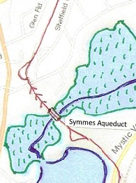
SYMMES RIVER AQUEDUCT
by Tom Raphael
Authorized in 1793 and constructed over a ten year period, the Middlesex Canal extended between the Charles River at Charlestown and the Merrimack River by East Chelmsford. Opening in 1804, it ran through Somerville, Medford, Winchester, Wilmington, Billerica and Chelmsford. For the best part of 50 years, the canal provided the principal means to transport natural resources from New Hampshire and Middlesex County to Boston, thereby contributing to that city’s economic and population growth and its becoming a world trading port. Returning inland, the canal carried the manufactured products and goods of the city and port. It was an immediate success. In his 1808 survey of internal improvements, Albert Gallatin, Secretary of the Treasury, called it “—the greatest work of its kind, to date, in the United States—".
 |
| Plan View: Symmes River Aqueduct and Gardiner’s Locks in Wilmington [Drawing by the Author] |
The canal channel was 30 feet wide and 3-1/2 feet deep, with an adjacent towpath 10 feet wide; it allowed “Luggage Boats" (freighters) and “Packets" (carrying passengers and light freight), up to 9-1/2 feet wide and 70 feet long, drawn by a horse, to travel in both directions; and rafts of timber, drawn by oxen, to travel down to market. Sixteen locks raised or lowered boats the 107 ft elevation between sea level and summit level at the Concord River, the principal source of water for the canal. Four more locks linked the canal to the Merrimack River.
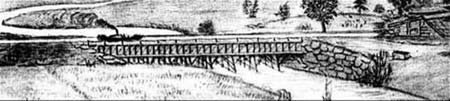
Eight aqueducts, all initially single-lane, carried the canal over significant rivers and streams. For that period, with no trained civil engineers, these were massive structures, initially of wood and later of stone. Traveling north, the first aqueduct spanned the Mystic River in Medford. Modified and improved several times in the last two centuries, it is now the Boston Avenue Bridge.
The next aqueduct, its location shown in the figure above and below, crossed the Symmes River, which ran through the meadows of the Symmes family.1 Today, these meadows are the middle and upper bays of Upper Mystic Lake in Winchester. But at that time, before the dam was built at the Partings, the water level of Upper Mystic Lake and its bays was 6 ft lower than it is today, and the meadows were dry. Immediately north of the aqueduct, a two-lock ‘staircase’, tended by a local Gardner family,2 raised or lowered the boats and rafts 12½ ft.
The Symmes River Aqueduct was laid out April 12, 1802, and completed the same year. It was 127 feet long, supported by two stone abutments, 120 feet apart, and three stone piers. The surface of the water in the aqueduct was 30 feet higher than that of the river. The aqueduct was thoroughly rebuilt in 1818 with new piers and abutments; it was then 103 feet long.3
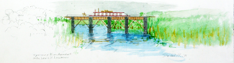
Original Symmes River Aqueduct
[watercolor, by Tom Dahill]
Still later, a January 17, 1826 report stated “the old aqueduct at Gardeners will need rebuilding in the course of a year".
A new aqueduct was built 100 feet long and 50 feet wide; its construction was described in a report dated January 17, 1828: - “Aqueduct at Symmes River was rebuilt, solid timber floors were sunk to the bottom of the river. 8 culvert walls 4 feet in thickness, 6 feet in height, and 100 feet in length, were laid six feet to seven feet apart, parallel with each other and directly under the old aqueduct. These culverts were covered with stones 8 ft in length and 18 x 18 inches in thickness resting upon the walls. A wall 6 ft in height and 4 ft in thickness was raised upon the ends of the culverts to support the banks of earth. After the stone work was completed, a bed of clay mortar 8 inches thick was laid on the covering stones. This platform was filled with soil to a level such that the canal continued across as if it was on solid ground, but it was made wider, 40 ft at the water line and 20 ft wide at the bottom with a depth of 5 ft ".4

Symmes River Aqueduct, as rebuilt in about 1827
[watercolor, by Tom Dahill]
The original aqueduct was single-lane, i.e., wide enough for one-way traffic at any given time, which eventually caused great delay. The new aqueduct was the full width of the canal and allowed boats to pass in each direction. An artist’s concept of this later structure is shown above.
This was a massive structure, comparable in size to the aqueduct at the Shawsheen River, the three double locks at Horn Pond in Woburn, or the flight of three stone locks entering the Merrimack River at Middlesex Village (now part of Lowell). Of these structures, the Shawsheen Aqueduct is the only one to survive by which to guage their size.
The quantity of stone, and number of blocks, required for this construction was as follows:
| Component | Calculation | SubTotal & Total |
| Piers | 4 ft x 6 ft x 50 ft x 8 piers | 21,600 cu ft |
| Covering | 100 ft x 50 ft x 2.25 ft sq | 11,000 cu ft of stone |
| Side Rails | 6 ft x 4 ft x 100 ft x 2 x 2.25 ft sq | 10,800 cu ft of stone |
| Total | 43,400 cu ft ÷ 18 cu ft/block | 2,411 blocks |
The Symmes Aqueduct was still intact long after the canal was abandoned. In 1864 a dam was built at the Partings between the upper and lower Mystic Lakes, to create a reservoir to supply water to Somerville and Charlestown. This raised the water level in the upper lake by six feet, thus filling the culverts supporting the aqueduct to the base of the stone platform.
As the winter ice broke in 1865, the culverts were blocked, causing an ice jam, which raised the waters of the river back to Bacon’s Pond and causing house basements in Winchester to flood. When this happened again the following winter, the townsfolk dynamited the aqueduct to free the jam.5
The remainder of the aqueduct was dismantled; thereafter the granite stones were strewn about and the town folks would haul them off for use as walls and foundations of houses. Several hundred were dragged up to the Brooks Estate and some can be seen in Winchester’s Town Forest. Photographs of these stones are shown here.
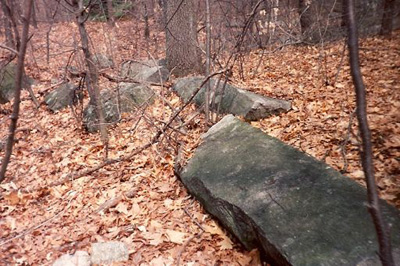 Granite Blocks from the Symmes River Aqueduct strewn about in the Town Forest [Photo by the Author] |
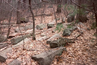 More Granite Blocks from the Symmes River Aqueduct [Photo by the Author] |
When the huge Brooks Estate was broken up, about half of the stones. were located in a subdivision adjacent to the portion that became the Winchester Town Forest. Later, when the owner planned to build Briarwood Lane and houses, the Middlesex Canal Commission negotiated to have the historic stones salvaged and delivered to a safe facility at the Winchester-Woburn line. Plans are for them to be used for a restoration at the site of the canal and aqueduct at Sandy Beach.
Today, the most obvious remnant of the aqueduct is the south end abutment, shown below. Since the upper basin of the Mystic Lakes was 6 ft lower when the aqueduct was built, what remains of the span of the aqueduct, its base and its stones, are mostly submerged or covered by earth.
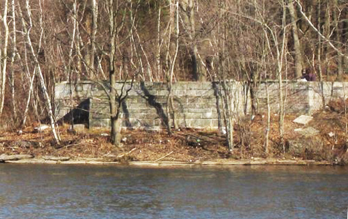
Symmes River Aqueduct, south abutment [Photo by the Author]
References:
1. On the river near Bacon Street, Symmes ran a mill which included a machine shop equipped with a lathe and trip hammer. At some point, John L. Sullivan purchased half interest in the machine shop where he built rotary steam engines on the design of Samuel Morey. These were derivatives of the engine used in the Merrimack, a steam towboat completed in 1818 and used on the Merrimack River. See the February 2010 issue of Towpath Topics, at middlesexcanal.org/towpath, for more information.
2. Another Gardner family ran the tavern, on Cambridge Street near what is now Church Street.
3. Lewis L. Lawrence; The Middlesex Canal, 1942 manuscript published by the Middlesex Canal Association, p-111.
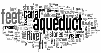
“Word Cloud" based on text from the previous article
generated by http://www.wordle.net/create
THOREAU ON THE CONCORD RIVER AND MIDDLESEX CANAL
by Howard B. Winkler
This article extracts the parts of Henry David Thoreau’s book, - A Week on the Concord and Merrimack Rivers - that relate to the Concord River and Middlesex Canal. The Thoreau brother’s excursion was actually a two week trip of boating on the rivers, overland travel to the base of Mount Washington, and climbing to its summit.
In his book, Thoreau frequently digresses from reporting on his travels to writing about history, poetry, religion, and philosophy. The entire book is available on line at http://www.gutenberg.org/cache/epub/4232/pg4232.html.
extracts from
A WEEK ON THE CONCORD AND MERRIMACK RIVERS
Outbound - down the Concord River, through the Middlesex Canal, to the Merrimack River
At length, on Saturday, the last day of August, 1839, we two, brothers, and natives of Concord, weighed anchor in this river port; for Concord, too, lies under the sun, a port of entry and departure for the bodies as well as the souls of men; one shore at least exempted from all duties but such as an honest man will gladly discharge. A warm drizzling rain had obscured the morning, and threatened to delay our voyage, but at length the leaves and grass were dried, and it came out a mild afternoon, as serene and fresh as if Nature were maturing some greater scheme of her own. After this long dripping and oozing from every pore, she began to respire again more healthily than ever. So with a vigorous shove we launched our boat from the bank, while the flags and bulrushes courtesied a God-speed, and dropped silently down the stream.
Salmon, Shad, and Alewives were formerly abundant here, and taken in weirs by the Indians, who taught this method to the whites, by whom they were used as food and as manure, until the dam, and afterward the canal at Billerica, and the factories at Lowell, put an end to their migrations hitherward; though it is thought that a few more enterprising shad may still occasionally be seen in this part of the river. It is said, to account for the destruction of the fishery, that those who at that time represented the interests of the fishermen and the fishes, remembering between what dates they were accustomed to take the grown shad, stipulated, that the dams should be left open for that season only, and the fry, which go down a month later, were consequently stopped and destroyed by myriads. Others say that the fish-ways were not properly constructed. Perchance, after a few thousands of years, if the fishes will be patient, and pass their summers elsewhere, meanwhile, nature will have levelled the Billerica dam, and the Lowell factories, and the Grass-ground River run clear again, to be explored by new migratory shoals, even as far as the Hopkinton pond and Westborough swamp.
As we said before, the Concord is a dead stream, but its scenery is the more suggestive to the contemplative voyager, and this day its water was fuller of reflections than our pages even. Just before it reaches the falls in Billerica, it is contracted, and becomes swifter and shallower, with a yellow pebbly bottom, hardly passable for a canal-boat, leaving the broader and more stagnant portion above like a lake among the hills. All through the Concord, Bedford, and Billerica meadows we had heard no murmur from its stream, except where some tributary runnel tumbled in.
But now at length we heard this staid and primitive river rushing to her fall, like any rill. We here left its channel, just above the Billerica Falls, and entered the canal, which runs, or rather is conducted, six miles through the woods to the Merrimack, at Middlesex, and as we did not care to loiter in this part of our voyage, while one ran along the tow-path drawing the boat by a cord, the other kept it off the shore with a pole, so that we accomplished the whole distance in little more than an hour. This canal, which is the oldest in the country, and has even an antique look beside the more modern railroads, is fed by the Concord, so that we were still floating on its familiar waters. It is so much water which the river lets for the advantage of commerce. There appeared some want of harmony in its scenery, since it was not of equal date with the woods and meadows through which it is led, and we missed the conciliatory influence of time on land and water; but in the lapse of ages, Nature will recover and indemnify herself, and gradually plant fit shrubs and flowers along its borders. Already the kingfisher sat upon a pine over the water, and the bream and pickerel swam below. Thus all works pass directly out of the hands of the architect into the hands of Nature, to be perfected.
As we passed under the last bridge over the canal, just before reaching the Merrimack, the people coming out of church paused to look at us from above, and apparently, so strong is custom, indulged in some heathenish comparisons; but we were the truest observers of this sunny day.
By noon we were let down into the Merrimack through the locks at Middlesex, just above Pawtucket Falls, by a serene and liberal-minded man, who came quietly from his book, though his duties, we supposed, did not require him to open the locks on Sundays. With him we had a just and equal encounter of the eyes, as between two honest men.
The movements of the eyes express the perpetual and unconscious courtesy of the parties. It is said, that a rogue does not look you in the face, neither does an honest man look at you as if he had his reputation to establish. I have seen some who did not know when to turn aside their eyes in meeting yours. A truly confident and magnanimous spirit is wiser than to contend for the mastery in such encounters. Serpents alone conquer by the steadiness of their gaze. My friend looks me in the face and sees me, that is all.
The best relations were at once established between us and this man, and though few words were spoken, he could not conceal a visible interest in us and our excursion. He was a lover of the higher mathematics, as we found, and in the midst of some vast sunny problem, when we overtook him and whispered our conjectures. By this man we were presented with the freedom of the Merrimack. We now felt as if we were fairly launched on the ocean-stream of our voyage, and were pleased to find that our boat would float on Merrimack water. We began again busily to put in practice those old arts of rowing, steering, and paddling. It seemed a strange phenomenon to us that the two rivers should mingle their waters so readily, since we had never associated them in our thoughts.
Rising at an equal height with the Connecticut, the Merrimack reaches the sea by a course only half as long, and hence has no leisure to form broad and fertile meadows, like the former, but is hurried along rapids, and down numerous falls, without long delay. The banks are generally steep and high, with a narrow interval reaching back to the hills, which is only rarely or partially overflown at present, and is much valued by the farmers. Between Chelmsford and Concord, in New Hampshire, it varies from twenty to seventy-five rods in width. It is probably wider than it was formerly, in many places, owing to the trees having been cut down, and the consequent wasting away of its banks. The influence of the Pawtucket Dam is felt as far up as Cromwell’s Falls, and many think that the banks are being abraded and the river filled up again by this cause. Like all our rivers, it is liable to freshets, and the Pemigewasset has been known to rise twenty-five feet in a few hours. It is navigable for vessels of burden about twenty miles; for canal-boats, by means of locks, as far as Concord in New Hampshire, about seventy-five miles from its mouth; and for smaller boats to Plymouth, one hundred and thirteen miles. A small steamboat once plied between Lowell and Nashua, before the railroad was built, and one now runs from Newburyport to Haverhill.
Return - from the Merrimack River, through the Middlesex Canal, and up the Concord River
When we reached the great bend just above Middlesex, where the river runs east thirty-five miles to the sea, we at length lost the aid of this propitious wind, though we contrived to make one long and judicious tack carry us nearly to the locks of the canal. We were here locked through at noon by our old friend, the lover of the higher mathematics, who seemed glad to see us safe back again through so many locks; but we did not stop to consider any of his problems, though we could cheerfully have spent a whole autumn in this way another time, and never have asked what his religion was. It is so rare to meet with a man out-doors who cherishes a worthy thought in his mind, which is independent of the labor of his hands. Behind every man’s busy-ness there should be a level of undisturbed serenity and industry, as within the reef encircling a coral isle there is always an expanse of still water, where the depositions are going on which will finally raise it above the surface.
…
We endeavored in vain to persuade the wind to blow through the long corridor of the canal, which is here cut straight through the woods, and were obliged to resort to our old expedient of drawing by a cord. When we reached the Concord, we were forced to row once more in good earnest, with neither wind nor current in our favor, but by this time the rawness of the day had disappeared, and we experienced the warmth of a summer afternoon. This change in the weather was favorable to our contemplative mood, and disposed us to dream yet deeper at our oars, while we floated in imagination farther down the stream of time, as we had floated down the stream of the Merrimack, to poets of a milder period than had engaged us in the morning. Chelmsford and Billerica appeared like old English towns, compared with Merrimack and Nashua, and many generations of civil poets might have lived and sung here.
…
We had made about fifty miles this day with sail and oar, and now, far in the evening, our boat was grating against the bulrushes of its native port, and its keel recognized the Concord mud, where some semblance of its outline was still preserved in the flattened flags which had scarce yet erected themselves since our departure; and we leaped gladly on shore, drawing it up, and fastening it to the wild apple-tree, whose stem still bore the mark which its chain had worn in the chafing of the spring freshets.
COLONIAL CURRENCY
HOW IT AFFECTED THE REVOLUTION AND THE MIDDLESEX CANAL
by Thomas Raphael
A recent article in Forbes Life, titled “Colonial Currency", by Jonathan Keats, reported that there has been a new interest in collecting and auctioning old colonial paper currency. One sheet of notes, totaling $370, was recently auctioned for $28,750 in New York. The potential value has prompted collectors to search for previously ignored old notes and they have been finding a wide variety of them, printed between 1690 and 1779.
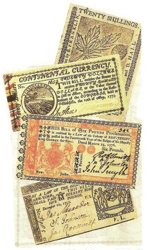 |
| At Auction, by Jonathon Keats, Forbes Life |
The article points out that the collecting of Colonial era currency requires one to be interested in searching out the vast variety of paper notes which have been around with little interest and value. Each has a story to tell, adding up to a history of American Independence and post-war development. Some of the stories have been used here to paint a picture of that period.
Massachusetts is credited with being the first in the Western world when in 1690 it issued paper currency with a face value totaling £7,000. A year later Massachusetts printed an additional £40.000 in various pound and shilling values. One 1790 Massachusetts issue had the motto “Come over and help us". Other colonies from New York to South Carolina followed suit and began issuing their own currencies.
In the 17th Century and even into the 18th Century there were still many alchemists in the American Colonies who were experimenting with transmuting common available metals into gold or silver. Both Paul Revere and Benjamin Franklin were known to have conducted such experiments. When all else failed they turned to printing “bills of credit" with simple numbers on slips of paper. It was common practice for many to barter for their basic needs, but with improving conditions in the colonies and the desire for the niceties of life, the need for currency other than gold and silver prompted people to use and accept promissory notes and script.
In England, the Crown watched these goings on with growing concern. One standard for collectors of Colonial Currency, Eric P. Newman’s “Early Paper Money in America" is like an 89 year history of the rising hostilities with England. This money, as well as the Continental Dollar script authorized by the Continental Congress, would fund the American Revolution, while causing serious inflation and thus giving rise to the phrase “not worth a Continental".
After shots were fired in Massachusetts in 1775, setting off the Revolution, the Continental Congress started printing the Continental Dollars. George Washington freely paid the volunteers and bought their uniforms, guns and powder, and provisions for his army with them as well with simple scripts. It was a smart move since these notes kept alive the entire American effort with nothing more to back them than printing the Revolutionary motto “Freedom is more precious than Gold".
Interest in these has become even greater when it was discovered that British operatives had tried to undermine the Revolutionary effort by printing and flooding the areas with counterfeit notes. One newspaper from Britain surfaced in New York offering to supply travelers with any number of counterfeit Continental Dollars for the price of the paper per ream. The volume of currency flooded the market and resulted in devaluation, causing the values to fall to 50% or even as low as 10%. Many Tories were identified by their refusal to accept the Continentals for face value.
As notes are found, they tell the story of the hostility of the Colonies to the mother country. A private 1734 New Hampshire note bears the slogan “Benificio Commerci" trying to predict a peaceful coexistence with the British. On the other hand a 1775 Maryland note shows an image of George III trampling the Magna Carta while burning an American city. The note was written in payment for the manufacture of gun powder.
Paul Revere, as a metal smith and engraver, cut private plates for Massachusetts depicting a sword wielding patriot with printing “Defense of American Liberty". Benjamin Franklin invented one of the earliest safeguards against counterfeiting by making a plaster cast of the unique pattern of a leaf and casting it into a plate for printing onto currency. Some of the notes contain the signatures of signers of the Declaration of Independence and thus have even higher value. Some bills have notes “Tis death to counterfeit". There were threats of capital punishment and branding or ear-cropping, but the sheer number and variety made it ineffective for judges to prosecute. However, some counterfeits have survived in the records and are particularly valuable.
After the Revolution, the value of the Continental collapsed from one tenth to as low as 1/40. In 1780, Alexander Hamilton, Washington’s Secretary of the Treasury, convinced Congress to issue $50,000,000 in 4% United States Bonds, establish the United States Bank, and pay off the notes at full value. Those who had accumulated the discounted notes were suddenly wealthy.
An interesting aspect was that, while all European coins were in use in the colonies, the Spanish silver Doubloon was one of the more popular. It paid an interesting role after the Constitution was adopted and Congress had to address the question of official United States currency. The Doubloon was accepted as official US currency up to 1843 and the Dollar was equivalent to one Doubloon or eight Real. Since the Spanish had based the value of the silver content of the Real on the weight of silver of one German Deutschmark, the value of the Dollar was in effect based on a silver standard. The Doubloon was scored so it could be cut into eight Real or “pieces of eight". It was also possible to cut into quarters or “two bits", the American slang for a quarter or 25 cents.
The wealthy merchants, in the thriving city of Boston, were faced with a city with the best port in the colonies, a full day’s sailing closer to Europe, but which had no navigable river to access the interior lands and tap the wealth of the natural resources. A group, formed and incorporated as the Proprietors of the Middlesex Canal Company, undertook to build a canal from Boston to a point above the falls, in what is now Lowell, connecting the Charles River with the Merrimack River and eventually to New Hampshire’s Capital at Concord. It was one of the first corporations and the Company sold bonds from a store in Boston, becoming the first stock exchange in the United States. An interesting point is the stock was sold in eights of a dollar and all stocks continued to do so until 2002, when the decimal system was adopted.
PLANS IN THE WORKS TO RESTORE LOCAL WATERWAY
by Max Bowen / Becki Harrington-Davis,
Billerica Minuteman, posted Jul 19, 2011
Reprinted with permission of Max Bowen
Billerica, Mass. —
These are visible remnants of Middlesex Canal, which ran 27 miles from Lowell to Boston, providing a cargo transportation route that helped launch the industrial revolution in Massachusetts.
Two centuries later, an organization hopes to restore remaining areas of the canal and pepper the route with historic signs to educate future generations. The Middlesex Canal Association [sic, Commission], which runs a museum in North Billerica, is seeking funding for a $3.5 million project restoring seven areas of the canal. One of these is in North Billerica at the Mill Pond, and is now 25 percent complete.
Tom Raphael, a Winchester resident and chairman of the state-appointed Middlesex Canal Commission Executive Committee, has been working to share canal history for 16 years. He said the association is seeking funding from the Federal Highway Enhancement Funds.
“We’re eligible for that money. I’m hoping I live long enough to see it," he said.
Raphael, 85 (sic, 89), became interested in the history of the canal after hearing a member of the association give a talk at the Winchester Unitarian Society. When Raphael suggested the association work to restore the canal, members asked him, “Why don’t you do it?"
Raphael is a former commodore of the Winchester Boat Club, chairman of the committee that designed Winchester’s water treatment plant, and a deacon of the First Congregational Church. Raphael is a World War II Navy veteran and also worked as an industrial chemist, including at Polaroid, until he retired in 1986.
Now, Raphael spends his time working toward canal restoration and giving talks on its history. Most recently, he spoke at the Middlesex Canal Museum’s temporary canal exhibit at the West End Museum in Boston.
“It’s very interesting, that’s why I spend all my time doing it," he said.
Canal history
After the Treaty of Paris ended the American Revolutionary War in 1783, American colonists began building factories, using watermills for power. Wherever there was a natural change in water level, people built factories to produce leather, mortar, iron, textiles, iron and pottery, according to Raphael.
At the time, Boston had no real roads or rivers for transportation. Seeing a need, Gov. John Hancock passed a charter forming the Middlesex Canal Corporation and charged it with building a canal from Boston to Lowell, where it would meet up with the Merrimack River.
The 27-mile canal was 30 feet wide at the top and 20 feet wide at its floor. It was only 3.5 feet deep. Specialized boats made for use in the canal were up to 75 feet long and could hold up to 30,000 pounds of cargo. Often, the cargo was building materials: Bricks, lumber or granite.
The boats had no motors — they moved slowly along the canal pulled by single horses, which trotted alongside the canal on the towpath. The weight displacement of the water allowed a horse to gently tug the boats along at about 3 nautical miles per hour, Raphael said, as opposed to needing several horses or oxen to pull a wagon on land. Rafts of lumber were also floated along the canal.
When the canal needed to change elevation, the boats would enter a lock, where gates would close and create a chamber filled with water to raise the boat to the higher elevation. For a boat going to a lower elevation, the chamber would be drained down to the lower elevation. The owners of the locks collected tolls. The Middlesex Canal contained 20 locks, nine landings where boats could be loaded, 50 bridges to connect land or roads and eight aqueducts, where the canal crossed rivers.
The canal, which was lined with clay, took 10 years to build, from 1793 to 1803. Loammi Baldwin, the namesake of the Loammi Baldwin Mansion in Woburn, was the superintendent of construction. Baldwin hired local laborers to build the canal, asking men to bring their own tools.
Part of the reason construction took a decade was the lack of tools and trained civil engineers.
“You couldn’t go to buy a tool. All the tools were made by blacksmiths," Raphael said. “If you wanted a wagon, you had to build a wagon."
The peak years of use for the canal were 1819 to 1836. The waterway helped develop Lowell, the first planned industrial city, because the cotton mills could ship fabric down to Boston.
In 1836, the canal began being phased out. The steam engine was invented and a railroad was built along an alternate route to Lowell. Ironically, Raphael said, sons of the Baldwin family built the railroad, putting the canal built by Loammi Baldwin out of business.
Its influence on Billerica
The Middlesex Canal has played a major role in Billerica’s development over the years, according to Raphael. The Mill Pond was the source of water for the canal, as well as its high point.
“The area of homes and taverns were the result of the canal," Raphael wrote in an email. “ It was one of the major landings of goods from NH going down to Boston as well as goods returning."
Some of the businesses which operated around the canal included a saw mill for, mill works and wood working shops, iron fabricating shop, storage buildings, boat yard, horse stables, a boat landing and lock tenders and operators quarters.
MISCELLANY
Endowment Fund - The Middlesex Canal Association Endowment Fund was initiated with funds given in honor of past President Burt VerPlanck at his passing. This represents our future. When you make your final plans we hope you will consider including us.
Web Site - http://www.middlesexcanal.org. Please check the site from time to time for new entries.
Museum & Reardon Room Rental - The facility is available at very reasonable rates for private affairs, and for non-profit organizations’ meetings. The conference room holds up to 60 people and includes access to a kitchen and rest rooms. For details and additional information please contact the museum at 978-670-2740.
Towpath Topics is edited by Bill Gerber and Robert Winters.
Corrections, contributions, and ideas for future issues are always welcome.