
Middlesex Canal Association P.O. Box 333 Billerica, Massachusetts 01821
www.middlesexcanal.org
| Volume 51 No. 1 | September 2012 |
MCA ACTIVITIES
Mark your calendars!
A Middlesex Canal Bicycle Ride: will take place on Sat, Sept 29 along the length of the Middlesex Canal, from Charlestown north to Middlesex Village, west of Lowell, with multiple stops along the way.
The MCA-AMC Spring Walk: will take place on Sun, Oct 21, in North Billerica, proceeding south toward Boston for 3 or 4 miles.
A Van Tour: in lieu of a Fall Meeting, to celebrate the fiftieth anniversary of the Middlesex Canal Association, there will be a van tour of the canal from Middlesex Village to Charlestown on Sunday, November 4th. J. J. Breen describes three parts of the tour in his President’s Message.
See the Calendar, following, for more information on our activities. Also included in the calendar are meetings and tours, sponsored by other organizations, in which you may want to participate. Please also check our web site periodically, at the URL noted above, which often lists canal-related events and topics of potential interest.
Golden Anniversary Issue The Middlesex Canal Association was founded in 1962 as the result of a rousing talk on the Canal at a meeting of the Billerica Historical Society in October 1961. The speaker was Harry J. Lasher, who challenged those present to do something about preserving the old Canal. |
PRESIDENT’S MESSAGE
by J. Jeremiah Breen, jj@middlesexcanal.org
“The Association was founded as the result of a rousing talk on the Canal at a meeting of the Billerica Historical Society in 1962. The speaker was Harry J. Lasher, who challenged those present to do something about preserving the old Canal.” So wrote Arthur L. Eno, President of the Association for its first decade, in the Sept. 1992 issue of Towpath Topics. To celebrate the fiftieth anniversary of the Association’s efforts to preserve the canal, a van tour of the canal from the Finneral plaque along the Merrimack to the Bostonian Society’s Landing No. 1 in Charlestown is being planned for Sunday, November 4th. Part of the tour will be the first success of the preservation effort, the gift in 1962 of 0.7 acre on the berm side of the canal between the summit pond and Rogers Street.
Signing the deed for the grantor, the North Billerica Co., owner of the Faulkner Mill, was John A. Morrill. The March 29, 1962 authorization by the board of directors for Morrill to sign doesn’t mention why the gift was made. Mr. Morrill’s mother bought the land, of which the 0.7s was a part, from the Faulkner Mfg. Co. in Aug 1919, but sold the land eight weeks later. This straw transaction was investigated to see if the Faulkners, who were coeval with the canal company, had some significance into 1962. None was found. The directors of the North Billerica Co. made the gift of the property contiguous to the canal because they were good fellows, according to Marshall Field, son of a director. Bill Taylor, a director who voted for the gift, says that Morrill owned 51% of the company.
The North Billerica Co. gave the property to the Billerica Historical Society because the canal association was not incorporated until 1964. The impetus for the gift probably came from Bob Valyou, president of the Historical Society, who was most persistent in seeking benefactors, according to Fred Lawson, a proprietor and honorary director of the Association, who was at that rousing Lasher talk in October '61. (The Association was founded in 1962 as stated in the quote at the beginning.)
In the future, the property will be landscaped as part of the canal park and also used for parking.
The fiftieth anniversary tour would include Boston Harbor and Concord NH if time were available in one Sunday to visit the ends of the interstate waterway of which the Middlesex Canal was a part. Instead, time at the ends of the Middlesex describing the interstate waterway will have to do.
The canal end at the Merrimack is shown on the 1840 survey of the estate of Cyrus Baldwin, agent of the canal company and eldest of Loammi’s children, and on Google Earth, based on the survey. With the locks buried and the river out of sight, the better location from which to talk about the northern terminus is from the north bank, where the Finneral plaque is directly opposite. (The mother of the sailor whom the plaque commemorates doesn’t know why the site opposite the canal was chosen by Senator Tsongas.) The plaque is 170' downriver of the UMass Lowell boathouse, 500 Pawtucket Boulevard, Lowell 01852. The tour van can park at the boathouse or at the curb forty feet from the plaque.
At Charlestown, the tide lock at the milldam is shown on the 1844 plan of the canal company’s property (http://tinyurl.com/char1844). The plan is on page 102 of Mary Stetson Clarke’s Middlesex Canal. Based on the plan, a Google Earth view (http://tinyurl.com/char2012) also shows the location of the Bostonian Society’s plaque, Charlestown Landing No. 1 at ~ 34 Essex St., Charlestown 02129. The tour van could park on A Street aside the tumulus in the corner with Rutherford Avenue. Rather than the grave of a Charlestown chieftain, the mound might cover the stones of the tide lock and mill, heaped there when new Rutherford Avenue was built. After Prof. Douglas Adams and Col. Wilbar Hoxie, president and vice-president of the Association, respectively, explored remnants of the lock at an excavation in Rutherford Avenue, they gave a talk with photos and maps at a 1972 meeting of the Association, but no article was done for Towpath Topics, leaving the location to be re-discovered.
Fortunately, the tourists of the fiftieth anniversary when parked aside the mound will have canal motif no. 1, the Charlestown Millpond, painted by Thomas Dahill and reproduced on a postcard, handed to them as a remembrance of the past and as a souvenir of the anniversary.
J. Jeremiah Breen
TABLE OF CONTENTS
MCA Activities
President’s Message (J.J. Breen)
Calendar of Events
Happy Birthday to Lou Eno
Remembering Cathy Lawson (Gerber)
Updates - Nolan Jones
Middlesex Canal Commission Receives Grant (Raphael)
The Convent by the Middlesex Canal (Seaburg)
Update - Baldwin Genealogy (Gerber)
More about the Baldwin Dry Docks (Gerber)
A Packet on the Merrimack? (Gerber)
A Boat Load of Cordwood & A Mystery (Gerber)
Miscellany
CALENDAR OF EVENTS
Middlesex Canal Association (MCA) and related organizations
First Wednesday - MCA Board of Directors’ Meetings - The Board meets at the Museum, from 3:30 to 5:30pm, the first Wednesday of every month, except July and August. Members are always welcome to attend.
Wed, Sept 26, 2012 at 7:00pm - The Historical Society of Watertown will host a documentary film by Roger Hagopian: “The Canal That Bisected Boston” in the meeting room of the Watertown Free Public Library, 123 Main Street, Watertown, MA. For more information please contact Joyce at 781-899-7239 or <joycekel at aol dot com>.
When initially completed, the Middlesex Canal terminated at the Charlestown Mill Pond near the Sullivan Square T Station. An ingenious method was devised for pulling boats across the Charles River using a warp line that spanned the distance, marked at intervals by floats tethered by weights at the bottom. Hand-over-hand, luggage boats and rafts of timber were pulled along this line, from the Charlestown Mill Pond across the river to Barton’s Point.
In 1805, a canal was dug through the causeway sand bar on the north side of the Boston Mill Pond, and boats were then taken across the pond and through a widened and deepened Mill Creek to reach Boston Harbor; thus Boston was completely bisected by the Canal. In 1808 Charles Bulfinch devised a plan to fill in the mill pond and designed the Bulfinch Triangle. At the top of the triangle, today’s Causeway Street marks the location of the sandbar. Paralleling today’s Canal Street, the Mill Creek Canal ran through the center of the triangle and continued along the creek.
Mr. Hagopian is a board member of the Middlesex Canal Association. A history lover since his youth, Roger is a 1972 graduate of the University of Massachusetts at Boston, where he received his degree in music. His films include: 1996 – Journey Along the Middlesex Canal; 1999 – Journey of an Armenian Family; 2002 – Memories of Marash, The Legacy of a Lost Armenian Community; 2006 – Victory at Van; 2006 – Our Boys, Armenienian-American World War II Veterans; 2007 – Memory Fragments of the Armenian Genocide; annd 2009 – Destination Watertown: The Armenians of Hood Rubber. He has presented his films at high schools, universities, libraries, community centers and private homes. “For me, video is a way of telling history that is educational, multidimensional, and compelling.”
Sponsored by the Watertown Historical Society, Edmund Fowle House, 28 Marshall Street, Watertown, MA; 617-923-6067, www.HistoricalSocietyOfWatertownMA.org. All meetings are free and open to the public.
Sat, Sept 29, 2012, Bicycle Tour of the Historic Middlesex Canal. MassBike, the Somerville Historic Preservation Commission, the Middlesex Canal Commission and the Middlesex Canal Association will sponsor the 11th annual bicycle tour of the canal which was the “big dig” of late 18th century Massachusetts. Completed in 1803 after 10 years of construction, the Canal connected the Merrimack River, west of what is now Lowell, with the Charles River at Sullivan Square in Charlestown. The Canal provided passenger and freight service for 50 years. It pioneered many innovations and in many ways served as a model for later canals, notably including the Erie Canal.
We will meet at 9:00 AM at the Canal marker on the Sullivan Square MBTA station. From there we will ride about 28 miles to the Mill Village and Canal Museum by the Concord River Millpond in North Billerica. We’ll stop for lunch in Woburn, so please bring a lunch. We should get to North Billerica in time for anyone who wants to catch the 3:07 PM train back to Boston. The ride will then follow the northern section of the Canal another 10 miles to Lowell in time to catch the 5:00 PM train back from there.
The ride will be an easy one for most cyclists; the route is pretty flat and we will average 5 miles per hour. Along the way we will stop at: several canal remnants and restored sections; the Mansion of Loammi Baldwin, chief engineer for the Canal (for whom the Baldwin apple is named, discovered during an early canal survey); the two remaining aqueducts (which carried the Canal over rivers and brooks); and the northern end of the floating towpath that enabled horses to tow boats across the Concord River.
The ride will be led by Dick Bauer of the Somerville Historic Preservation Commission and the Middlesex Canal Commission, Robert Winters of the Middlesex Canal Association, and Bill Kuttner of the Shirley-Eustis House. Steady rain cancels. For more information, contact Dick at <dick.bauer at alum dot mit dot edu> (617-628-6320), Robert at <robert at middlesexcanal dot org>, or Bill at <bkuttner at ctps dot org> (617-973-7132). For more information about the Middlesex Canal go to: www.middlesexcanal.org, &/or www.massbike.org/resources/rides.htm.
Sept 30 - Oct 2, 2012 - Canal Society of New York - State Canal Conference, Oswego, New York. For details www.newyorkcanals.org.
Oct 3-15, 2012 – Canal Society of New York - Canals and Waterways of Belgium – For details, see www.newyorkcanals.org.
Sat, Oct 13, 2012 - Canal Society of Ohio - Canal Days in Roscoe Village, Coshocton, Ohio. For details see http://www.canalsocietyohio.org/.
Sat, Oct 13, 2012 - Society for Industrial Archeology announces: The Friends of Wareham’s History, the Wareham Historical Society, and the Wareham Historical Commission will host an “Iron Heritage Trail” summit to be held at “The Old Methodist Meeting House”, 495 Main St., Wareham MA at 10:00 AM. Purpose is to discuss the “Iron Trail” and to organize to support the communities, organizations and individuals involved in the preservation and interpretation of their own iron industry sites, and the associated history and culture. Sara Wermiel will present ‘the History of the Iron Industry in Southeastern Mass’. Contact: Mack Phinney, P.O. Box 118, West Wareham MA 02576, (508-295-4225), <mbp43mack at gmail dot com>
Sun, Oct 21, 2012. Joint MCA-AMC Fall Middlesex Canal Walk. Meet at 1:30pm at the Middlesex Canal Museum and Visitor Center in the Faulkner Mill in North Billerica. The walk will be over 3-4 miles of generally level wooded terrain and streets, for 2-3 hours, rain or shine. The route follows the canal south of the Concord River. Sites to be visited include a guard lock, an anchor stone for the floating bridge which once carried the towpath across the river, and many stretches of canal, some still watered. The Museum, Visitor Center and bookstore will be open from 12:00pm-4:00pm. No dogs, please. Phone 1-978-670-2740. L Robert Winters ((617) 661-9230; <robert at middlesexcanal dot org>), CL Roger Hagopian ((781) 861-7868 to 10pm).
Directions to the Museum/Visitors Center: Telephone: 978-670-2740.
By Car:
From Rte. 128/95, take Route 3 toward Nashua, to Exit 28 “Treble Cove Road, North Billerica, Carlisle”. At the end of the ramp, turn left onto Treble Cove Road toward North Billerica. At about ¾ mile, bear left at a fork. After another ¾ mile, at a traffic light, cross straight over Route 3A. Go about ¼ mile to a 3-way fork; take the middle road, Talbot Street, which will put St. Andrew’s Church on your left. Go about ¼ mile and bear right onto Old Elm Street. Go about ¼ mile to the falls, where Old Elm becomes Faulkner Street; the Museum is on your left and you can park across the street on your right, just beyond the falls.
From I-495, take exit 37, N. Billerica, south to the road’s end at a “T” intersection, turn right, then bear right at the Y, go 700' and turn left into the parking lot. The Museum is across the street.
By Train: The Lowell Commuter Line runs between Boston’s North Station and Lowell’s Gallagher Terminal. Get off at the North Billerica station, which is one stop south of Lowell. From the station side of the tracks, the Museum is a 3-minute walk down Station and Faulkner Streets on the right side.
Oct 19-22, 2012 - Pennsylvania Canal Society’s tour of the Union Canal’s Pine Grove extension. Contact: Bill Lampert, <indnbll at yahoo dot com>.
Sun, Oct 21, 2012 - Miami and Erie Canal Corridor Association (MECCA) - “Walk With Nature”. Enjoy a crisp fall day along the Towpath Trail as you walk from St. Marys to Glynwood Road (or to shorten waiting time, the other way around) and take a bus back to your starting point. Along the hike you can enjoy the Fall Festival in Memorial Park, the Pioneer Encampment, car show, music, food and entertainment. These programs are free and fun for the entire family.
November 4, 2012 - The Middlesex Canal Association will celebrate its fiftieth anniversary with a van tour of the canal, “the greatest work of the kind that has been completed in the United States.” So wrote Albert Gallatin in 1808. The tour will include a dinner in the Baldwin Mansion, home of the canal builder, and birthday cake at the canal museum. Celebrants will be driven to and from their hotel in Boston or Lowell, Massachusetts, both of which are National Historical Parks. Preferred hotels and rates will be posted in October. The tour will leave the museum, 71 Faulkner St, Billerica MA 01862, at 10:00 AM and return at 4:00 PM for cake and ice cream. Dinner at 2:00pm will be served by Sichuan Garden II, located in the Baldwin Mansion, 2 Alfred St, Woburn MA 01801. A check for $50/person payable to the Middlesex Canal Association should be mailed to the MCA, P.O. Box 333, Billerica MA 01821, before October 22nd, including an email address or phone number where we can contact you. Our contact is jj@middlesexcanal.org and our phone, 978-670-2740, is answered by a person when the museum is open, noon to 4 PM, weekends.
Thurs, November 8, 2012 - Miami and Erie Canal Corridor Association (MECCA) will hold a Canal Diggers Affair at St. Marys Eagles. This is a fundraiser for MECCA. Social Hour at 6 PM, Dinner at 6:30 PM. Entertainment, Live and Silent Auctions, Raffles, Cash Bar. Dinner tickets: $25/person. Contact: Neal Brady at 419·733·6451 or <meccadirector at nktelco dot net>.
April 5-7, 2013 - The Canal Society of Indiana’s spring tour of the Wabash & Erie Canal, Attica to Montezuma, Indiana. HQ: Sleep Inn, Danville, Illinois. See canal remains, murals, a covered bridge, a war memorial museum, a waterfall, and much more on this three-day adventure. More information to follow. 260-432-0279.
September 16--19, 2013 - The World Canals Conference in Toulouse, France. See www.worldcanalsconference.org for details.
HAPPY BIRTHDAY TO LOU ENO
by Betty Bigwood with input from Tom Dahill
On April 27, 2012, Arthur L. (Lou) Eno, Esquire, first President of the MCA, celebrated his 88th Birthday. Lou and a small group of Billerica Historical Society members started the Middlesex Canal Association 50 years ago, after a stimulating lecture by Harry Lasher.
I don’t believe the MCA would have existed without Lou. He was the driving force and had the legal expertise to form the association, write its by-laws, etc. Granted it was Harry Lasher whose lecture first challenged the Billerica Historical Society to save the Canal - and when he first displayed his “Lasher Map” - but it was Lou who took the bait. He provided free legal advice for years.

When I asked Lou what his proudest moment was - he said the series of events when the Shawsheen Aqueduct was given national standing with its plaque as an Engineering Landmark, when sections of the Canal were given Historical Standing and the dedication, and restoration of the section of canal in Wilmington which crosses under Rte. 129 to Lubbers Brook. While it was before my time here, there was quite a party.
When the Association began Lou lived in Billerica but moved to Westford a number of years ago. He has always been a charming man to whom people migrate. His wife is a dynamo. Lou and Ann have three children. “Now legally blind - macular degeneration- Lou navigates about his home with ease. He has some peripheral vision and he uses a device on his computer to help, but he rarely goes out.”
Lou speaks fluent French as it was his first language in Canada. Later in his law practice he catered to a French speaking cliental in Lowell. He graduated from Phillips Academy, Andover, Harvard College and Harvard Law School.
Although Lou and Tom Raphael graduated from Harvard College the same year; they didn’t know each other until they met at a MCA function at the Billerica Mill Pond in 1994 - Tom spotted Lou’s Harvard jacket. Celebrating the 200th anniversary of the September 1794 start of Middlesex Canal construction; Tom was dressed as Loammi Baldwin, ‘turned the first shovelful of earth’ that day, and offered his memorable prayer “May the Eye of Wisdom and the Eternal Mind aid this work designed for the Present and all Future Generations”. This was all part of Dave Dettinger’s 10 year series of commemorative reenactments of important events that preceded the 1803 opening of the canal.
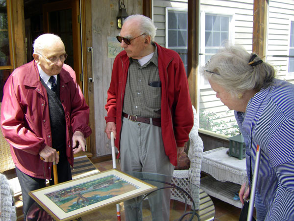
Tom Raphael, Louis Eno, and Betty Bigwood view a canal painting by Louis Linscott
Recently, Tom Raphael, Tom Dahill and I visited Lou at his home. While there we had an opportunity to examine an original canal-related painting by Louis Linscott. Linscott painted a series of Canal scenes for S. B. Goddard & Son Co’s calendars. His home was in North Woburn not far from where I live. Lou knew one of Linscott’s daughters; she was active in the MCA and gave him the painting. The MCA published eleven of his paintings in 1978, and copies of them have appeared as illustrations in various issues of Towpath Topics since then.
About Lou’s Linscott painting, shown below, Tom Dahill photographed it and writes: “I thought you might want a copy of the painting we saw at Lou’s house. I believe it is a tempera painting, an opaque watercolor. I had to do some work on it because the glass collected too many reflections. We have no name for it.” (I offer the one shown opposite. OTOH something calling attention to the beginning of another year’s operation might also be appropriate. BG)
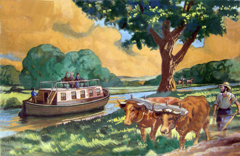
Springtime on the Middlesex Canal
REMEMBERING CATHERINE ANN (MASTERS) LAWSON
JUNE 29, 1937 - APRIL 23, 2012
By Bill Gerber
Catherine Ann (Masters) Lawson, of Billerica, age 74, died April 23, 2012, after a short illness. She was the beloved wife of Fred Lawson and mother of Zoe’ Lawson.
 I first met Fred and Cathy during preparations for, and the conduct of, the bicentennial re-enactment of Benedict Arnold’s 1775 march to Quebec (at the outset of our Revolutionary War). In our last time together, late last winter, Cathy cooked dinner for me. In the years in between I joined the Lawson’s and their friends in various marches and reenactments, in firing the return salutes from the State during the annual ceremonial July 4th turn-around of the USS Constitution, in re-roofing their house, and in many meetings and events relating to the Middlesex Canal. They were a delightful family to be with, usually pursuing some new quest, always playful and humorous, and sometimes a bit irreverent. Cathy’s passing leaves a void in my life too.
Born on June 29th,1937 in Brooklyn NY, Cathy spent most of her early life on her mother’s family’s farm in Billerica, Massachusetts. She graduated in 1954 from Howe High School, where she and Fred met. Last year, she and Fred celebrated their 50th wedding anniversary.
Cathy pursued a nursing career, graduated as an RN from Lowell General Hospital, earned a Bachelor of Science degree in nursing from Boston University in 1963 and worked at Boston City Hospital from 1957 to 1971.
Cathy led a life dedicated to helping others, and her interests were broad and deep. She was a member of The First Parish Church, Billerica and served on several of its boards and committees. She loved her gardens, maintained several at her home, and was a member of the Billerica Garden Club. She and her Great Uncle, A.Warren Stearns, planted many, many pine trees along Concord Rd. and along the Concord River in South Billerica.
She and Fred became heavily involved with 18th Century Reenacting, often with a Royal Irish Artillery Unit; Cathy was the 3rd woman in Massachusetts to become a licensed cannoneer. Zoe’s, their daughter’s, first pull-toy was a naval cannon carriage. A Mother’s Day present to Cathy, while pregnant with Zoe’, was an 18th century mortar, a ‘real one’ mounted on an authentic carriage. She also played the bass drum and was part of many Fife & Drum groups.
It was also her Great Uncle, Dr. A. Warren, who initiated her interested in the Billerica Historical Society and thereafter she often served on its board of directors.
Fred and Cathy were founding members of the Middlesex Canal Association (a BHS ‘spin-off’). In this endeavor it was Fred who was the researcher and often a speaker, both of which she fully supported. During speaking events, Cathy ran a ‘magic-lantern’ projector, with early 20th century glass slides, while Fred lectured on the canal.
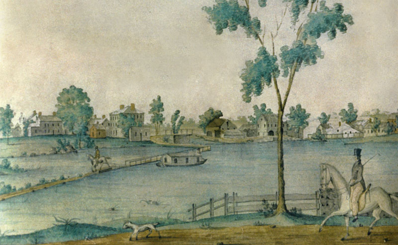
It was Cathy’s family, her Aunt Helen and Uncle Charlie Stearns, who donated funds to preserve the Jabez Ward Barton painting (ca1826) to the Billerica Historical Society - of a canal boat crossing the Concord River, towed by a horse on the floating towpath - see above. This painting has long been shared with the MCA, an extract from which has adorned the nameplate of Towpath Topics (MCA’s thrice annual newsletter) for the past five years.
A celebration of Cathy’s life was held at her home on June 30th. It was very well attended.
Fred and daughter Zoe’s address is: 187 Concord Road, Billerica MA 01821.
NOLAN & JOAN JONES - AN UPDATE
from input by Joan Jones
As most members know, Nolan, who served as President of the MCA for 18 years, had a stroke on the day of our May 2009 Annual Meeting. He never fully recovered and, eventually, he and Joan moved to Sacramento, CA, to be near Nolan’s daughter; they’ve been in an assisted living situation since arriving there. A few days ago, a note from Joan stated that they will be moving again, “to a larger facility with more in-house exercise classes and a PT center for Nolan plus lots more other kinds of activities. After August 27 you will find us at:
Atria Covell Gardens
111 Alvarado Ave., #C128
Davis, CA 95616
Davis is the town for University of California/Davis, 2 miles west of here. Should be nice. Our computers won’t be hooked up right away, but that’s not a surprise, is it?”
MIDDLESEX CANAL COMMISSION RECEIVES GRANT
FOR WALKING & BIKING TRAILS ALONG CANAL IN WOBURN
Adapted from a press release from OneWorld Boston
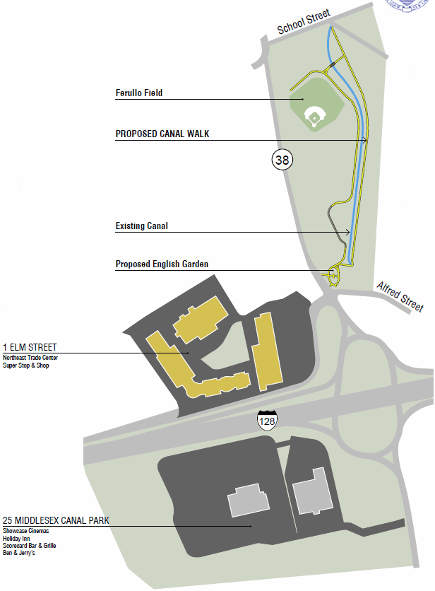
![]() ONEWORLD BOSTON, a Cummings Foundation affiliate, has awarded the Middlesex Canal Commission a $100,000 grant to support construction of walking and bike paths along the Middlesex Canal in Woburn, near the Baldwin Mansion, from Alfred Street to School Street.
ONEWORLD BOSTON, a Cummings Foundation affiliate, has awarded the Middlesex Canal Commission a $100,000 grant to support construction of walking and bike paths along the Middlesex Canal in Woburn, near the Baldwin Mansion, from Alfred Street to School Street.
HISTORY*:
The Middlesex Canal Commission was created in 1977 by an Act of the Massachusetts Legislature. The Purpose of the Commission is to return the Middlesex Canal to public use. The Middlesex Canal Commission (MCC) was charged with planning, acquiring, restoring, and maintaining the remaining segments of the Middlesex Canal. Through this endeavor the MCC will create the Middlesex Canal Heritage Park to inform, inspire and draw public attention to the nationally significant landmark located throughout Middlesex County. In addition, the restoration of the canal will provide recreational and educational benefits to visitors, and economic benefits to adjacent communities.
* All of the text to follow derived from: OneWorld Boston GRANT APPLICATION MIDDLESEX CANAL COMMISSION, Commonwealth of Massachusetts Program: ALFRED STREET to SCHOOL STREET, Towpath & Bike Path Construction, WOBURN, MASSACHUSETTS, April 2012
The Commission is comprised of: A representative from each of the Canal communities. - A State Representative and a State Senator - The Executive Director of the Metropolitan Area Planning Council (MAPC) - The Executive Director of the Northern Middlesex Council of Governments (NMCOG) - The Commissioner of the Department of Conservation and Recreation (DCR) - The Commissioner of the Massachusetts Department of Transportation (MassDOT).
Today the Middlesex Canal is a series of surviving segments, located primarily in the northern half of its route. Some exist as open water, some as overgrown rights of way, and some as actual structures. Stitching together these segments as a linear historic site and greenway will fulfill the goal of “returning the Canal to public use.” Our strategic objectives are tailored to the unique nature of each of the segments:
In order to facilitate the planning and implementation structure for the Middlesex Canal restoration the MCC has created a 5-phase Master Plan for the Reconstruction and Interpretation of the Canal. The 5 phases are listed below:
Phase 1 - Mill Pond (Billerica) – The goal of this phase is to integrate the Canal with surrounding historic landscape, recreational space, high-quality facilities, and greenway development. This Phase is in the 75% design submission. Construction estimate: $3.0 million
Phase 2 - Reconstruction of Extant Portions of the Canal – There are a number of well preserved portions of the Canal that are a high priority for protection, reconstruction, integration into the overall historic site and greenway development. A program study detailing each of these segments has been created. A concept study has been developed for two of these segments (Segment 5: Alfred Street to School Street in Woburn and Segment 6 Main Street to Burlington Avenue in Wilmington). A 25% design has progressed for Segment 5.
Phase 3 - Acquisition of Canal Properties – Due to ongoing development across the region is it critical to acquire (or otherwise permanently protect), link and provide public access to other Canal segments before they are lost forever. Major portions of the survey work and GIS mapping have been completed for this Phase.
Phase 4 - Creation of Canal-wide Interpretive Sites and Signage – The linkage of the Canal segments in Phase 2 and 3 will make it possible to provide consistent signage and other interpretive elements throughout the length of the Canal.
Phase 5 - Permanent Infrastructure: Museum, Headquarters, Maintenance – Phases 1 through 4 put the whole project together. Phase 5 provides the permanent infrastructure that will maximize the value of the Canal to the public. The Canal is currently utilizing 4,500 square feet of space at the Faulkner Mill Building at the Mill Pond area in Billerica as its museum and visitor center. The Museum is open on weekends from noon to 4 PM.
In addition to the 5-phase Master Plan the MCC has also completed the National Register Map Book and the Heritage Corridor Map Book, which detail the former layout of the canal and how it fits into the County’s current development. These books have been used to have the Middlesex Canal identified on the National Register of Historic Places.
PROGRAM INFORMATION
Program Name: Segment 5 - Alfred Street to School Street, Woburn, MA
Grant amount requested: $100,000
Name and Title of Program Manager: Thomas Raphael, Chairman
Geographic Area Served by Program: Woburn and Middlesex County, MA
Basic Budget Outlining Plan for Expending Grant Funds: See attached budget outline.
Past Program Expenditures and Any Anticipated Future Funding: See “History” above. Anticipated partial future funding from Boston Region Metropolitan Planning Organization (BRMPO)
Description: The goal of developing Segment 5 of the Middlesex Canal from Alfred Street to School Street in Woburn has two elements. First will be developing the canal’s towpath as a walking path while finding unique ways to restore and preserve the Canal cross-section. Second, the creation of a paved asphalt bike path will utilize the abandoned railroad bed and preserve the historic competition and ultimate replacement of the canal by the railroad. Situated adjacent to the Baldwin Mansion, 1790 House, Woburn’s Kiwanis Park, and with a connection to Ferullo Field this project will provide for over 10 acres of outdoor recreation for the residents of Woburn and visitors to the site. Many of the potential visitors to the segment work at the nearby office centers or live in the growing residential communities.
Although, the OneWorld Boston grant alone will not fund the entire project as described below, the MCC hopes to construct the segment in phases beginning with reconstructing the towpath and connecting it to pedestrian outlets at Alfred Street and School Street. The MCC believes that most if not all of this work can be funded through the requested grant funds. Once the towpath becomes open to the public and local residents and visitors realize the important historic landmark in their community, the MCC hopes this will encourage greater public support for next phases of construction of the segment.
The restoration of the canal can be coupled with the opportunity to highlight the historical significance of the surrounding community while providing public access and preserving an existing wildlife habitat. The restoration of the canal segment provides opportunities to incorporate interpretive features like the ruins of the stone abutments of Baldwin’s Bridge and the old Canal holding basin. The creation of an “English Garden” at the Kiwanis Park, pending final approval by the City, could serve to bring back the image of the era when the Middlesex Canal was the major transportation route for material goods from Boston to New Hampshire and an engineering marvel of its day.
A detailed description of each proposed project element follows:
Canal Restoration
The canal banks are no longer uniform in shape and heavily overgrown. It is proposed that segments of the canal visible at locations of access (School Street intersection) or public interest (Kiwanis Park) be fully restored. Restoration at these locations would involve accurately recreating the canal cross section. At areas visible from intersection streets, 100' restoration sections are recommended to provide a visual element for the passerby. At locations such as the Kiwanis Park, the canal along its entire length would be proposed for restoration.
Improvements to Ferullo Field
An important factor necessary for the success of the project will be access. Limited space is available for visitors of the canal to park and enjoy its amenities. Improvements to the existing facility parking at Ferullo Field would be incorporated in order to provide parking for the Canal and field.
Success of the Segment 5 will be measured by how it is used by the surrounding community and by the wealth of knowledge, enjoyment, and connection to the past they will gain by the integration of the canal into their lives. At a minimum having the towpath restored and bike path created with interpretive signs about the history of the canal would signify a definitive benchmark of the success of the canal. In addition, the MCC and the City plan on monitoring the use of the Canal to help gauge which Canal Segments can be restored next and to incorporate lessons learn from Segment 5’s restoration.
THE CONVENT BY THE MIDDLESEX CANAL
By Alan Seaburg
The story of the burning of the Convent in 1834: The St. Ursula Convent in Somerville was built in 1827 on Mount Benedict. When purchased the year before by Bishop Benedict Fenwick, the location had been a very productive farm. The brick convent replaced the original farmhouse. The bricks came from the nearby brickyards one of which was adjacent to the convent. Twelve nuns staffed the convent and it served as a school for young girls, both Catholic and Protestant, from eastern and southern states as well as from Quebec. It, and several related outbuildings, were completely destroyed by fire on the night of August 11, 1834 by a mob incited by prejudice against the Catholic Church, its faith, and its communicants. Fortunately the nuns were able to lead the 57 students then studying there to safety. During the next several years the ruins must have been a spectacular sight for those sailing by on the canal.
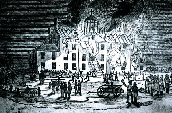
Destruction of the Urseline Convent, August 24, 1834
The leader of the mob was John R. Buzzell who was at that time working as a brick maker in Charlestown. Although indicted for this crime, at his trial a jury of his peers found him innocent. Years later Buzzell was to write: “The testimony against me was point blank and sufficient to have convicted twenty men, but somehow I have provided an alibi, and the jury brought in a verdict of not guilty.” The trial, no matter how much the judge who presided attempted to be judicially correct, was and still is similar to the so-called “fair” trials given in America’s southern states to white men who murdered black men, women, and children. Buzzell lived into his nineties; the ruins of the convent he helped to burn down were still visible for more than fifty years.
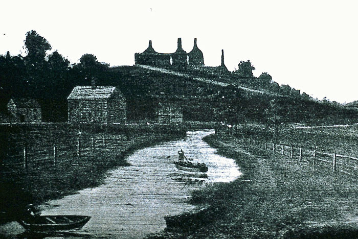 |
| Photos from the Leon Cutler collection |
Convent Ruins relative to the Middlesex Canal |
The story of the Middlesex Canal as it ran by the convent: As members of the Middlesex Canal Association, especially those who were fortunate to hear at this year’s annual meeting the lecture on the burning of the convent delivered by Dr. Nancy Lusignan Schultz, know already, as do regular readers of Towpath Topics, that along its way the Middlesex Canal passed through Somerville directly in front of the convent. See the watercolor the MCA artist, Thomas Dahill, made for The Incredible Ditch.
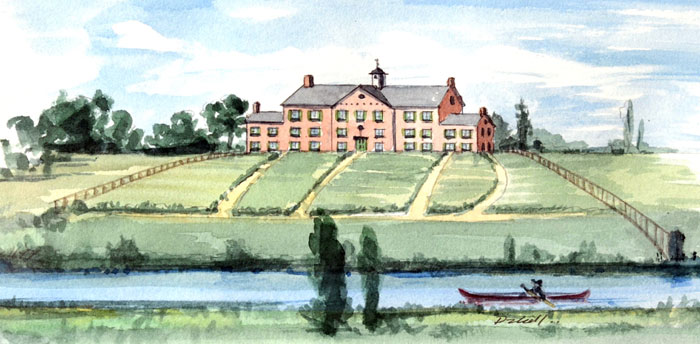 |
| Watercolor by Tom Dahill, used with permission of the artist |
| Urseline Convent, Charlestown MA, 1833 |
In the sources below one finds reliable data about the canal as it passed the convent, which is not, as far as I can tell, available in the books and articles written about the Middlesex. It comes most importantly from the statement Buzzell wrote as “Leader of the Mob,” which is found (in part) in Nancy Schultz’s fine volume. It deserves to be separately highlighted.
So here is what Buzzell wrote, just of the canal, in his statement: “The nunnery was situated about a quarter of a mile from the brickyard, [where he worked] on Mount Benedict, which lies about halfway between Bunker and Winter hills. It was a large three-story building of brick and stone, its length being I believe, 105 feet, and around it were several other smaller buildings—the cook-house, Bishop’s lodge, ice-house, and farmhouse and barn. In front of it, at the foot of the hill, ran the old canal from Lowell to Boston, which was at this point spanned by two small bridges.
“The tow-path ran on the south side of the canal until it reached the nunnery grounds, from which point the opposite side was used, the horses crossing over by means of bridges. Thus there was no tow-path between the canal and the grounds of the nunnery, although the canal company owned a strip of land a rod in width on that side, which they could have used for that purpose had they desired. The facts about this part of the canal I remember with great distinctness, because I had frequently repaired the tow-path here when I had a spare day from the brickyard.”
Later in the account there is a bit more about the canal. “One Saturday in June, I think, 1834, a man and his wife came from the country to Charlestown on a visit to a blacksmith named Lamson. During the day Mrs. Lamson and her guest, accompanied by a lady who lived near by, went to look at the canal, which was a curiosity to the country people at that time. When the party arrived at the bridges in front of the nunnery, they crossed over to the south side, and continued their walk close to the canal.”
Commentary: The great value of Buzzell’s description of the canal running by the convent is that he was an eyewitness to the fact. Further, his statement has increased validity because as he declared “I had frequently repaired the tow-path here.” How does his account of the towpath being on the east side up to the convent where, at least for a very short distance it ran on the west side, compare to other accounts?
Unfortunately most of the maps of the route of the canal do not indicate on which side the towpath was located. However, Bill Gerber, in a helpful essay on the subject, says the following: “Traveling north from the Charles River tidal lock, en route from the Charlestown Mill Pond to the Merrimack River, the towpath remained on the east side of the canal for about 11¾ miles, to Carter’s Accommodation Bridge. This was at a point about 20 chains (1 chain = 66 feet) north of the original site of the Baldwin Mansion.” But as the careful scholar he is he then indicated that sometimes this rule did not always prevail.
Later using Baldwin’s 1829 canal survey he writes this of the Somerville section: “In the 11 plus mile stretch between the southern terminus and the point where the change was made, the towpath was on the east side of the canal almost certainly because both the Charlestown Mill Pond (where timber and other goods brought down the canal were held until they could be disposed of) and Horn Pond and the Horn Pond feeder canal (the source of auxiliary water for the canal’s eastern division) were on the west side.” In this discussion east-west and north-south can be confusing as Gerber uses east-west, which is the correct terminology as the canal ran north, but Buzzell as we have seen uses south and north.
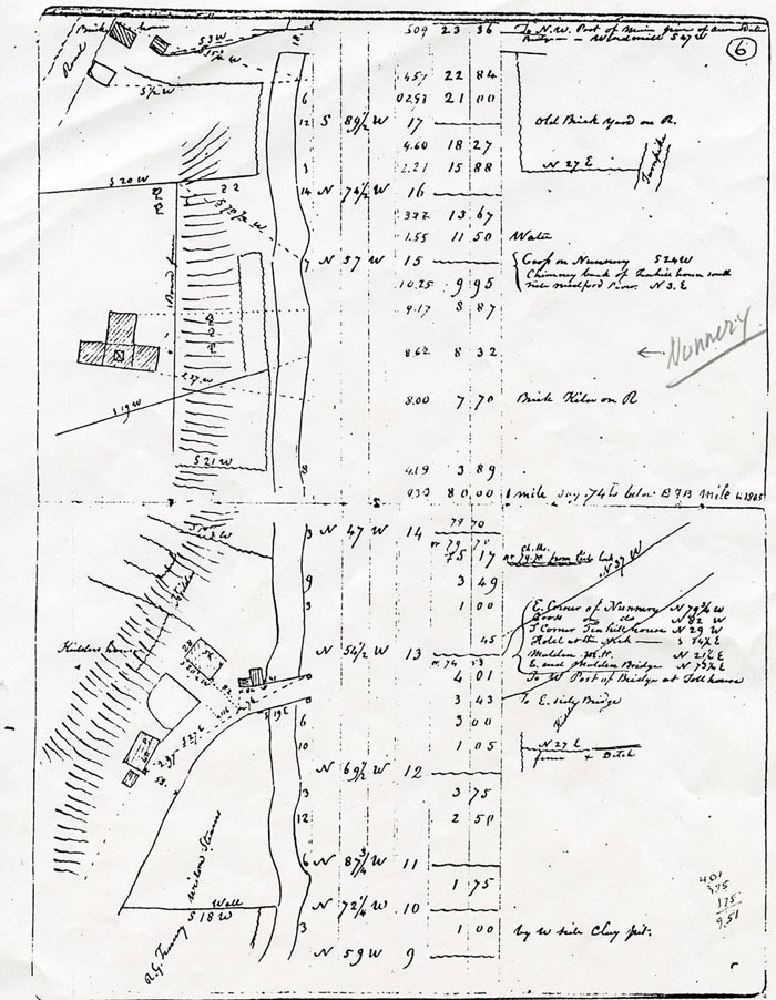
Location: Convent & School, vs Middlesex Canal from an 1829 Survey
Now my examination of Baldwin’s 1829 survey of the canal tells me this when one studies the section showing the canal passing the convent:
That the four blocks on the top of the hill represent the nunnery and next that the garden in front of the convent extends almost down to the canal and that just before it reaches the canal there is a little break. This would have been the small section owned by the canal company. Further, and remember that I am not engineer and so may be wrong, I fail to see that Baldwin has designated any towpath on either side of the canal. J. Jeremiah Breen who is an engineer does see a towpath here declaring, “The towpath was across the canal from the convent school based on the attached 1829 survey field notes.” [See the survey above].
To recapitulate, Buzzell’s eyewitness statement represents another piece of understanding regarding the canal’s towpath by the convent and lets us see that when it ran in front of the convent and its garden it had crossed from the eastern bank to the western. Later it crossed back again. The horses and oxen were able to easily make this change of towpaths from one side to the other thanks to the two nearest bridges. This change of towpaths then is yet another example of Bill Gerber’s statement that sometimes such changes did happen along the entire canal route.
Buzzell’s statement tells us one other fact about the old canal and even though it is one we all know about it is still good to come across another eyewitness to this fact. That fact is that the people living during its heyday loved to come out and sit and watch its flow of traffic between Charlestown and Middlesex Village and, of course, the reverse too. I love his expression, which called the canal “a curiosity to the country people at that time.” This was also true even to “city” people, such as Buzzell, working in Charlestown. It is similar, of course, to what happened, for example, after the opening in 2003 of the newly constructed cable-stayed Leonard P. Zakim Bunker Hill Memorial Bridge in Charlestown. When that occurred folks just wanted to drive, or walk, to see this “wonder” for themselves and that often meant driving their car/truck or walking across the bridge, usually in both directions. It is good to know that in the Age of Twitter old fashion curiosity is still alive and well.
Sources:
Schultz, Nancy Lusignan, Fire & Roses: The Burning of the Charlestown Convent, 1834, N.Y.: Free Press, 2000.
“Destruction of the Charlestown Convent: Statement by the Leader of the Mob,” in United States Catholic Historical Society, Historical Records and Studies, v. 12 (June, 1918) 66-75.
Bisson, Wilfred J., Countdown to Violence: the Charlestown Convent Riot of 1834, NY: Garland, 1989.
Note: there is but one reference to the canal in Bisson’s book: “The canal to the textile mills on the Merrimac passed through Charlestown as did the Lowell railroad, which would not bridge the Charles River to Boston until later. Thus, Charlestown had Northern Massachusetts and much of New Hampshire as its hinterland. Because of that circumstance, much of Charlestown’s labor force was engaged in transportation as truckmen, canalmen, teamster’s stablers, stevedores, and wharfingers. A number of merchants also was (sic) involved in this trade.”
Gerber, Bill, “On Which Side Was the Towpath Built, And Why?” Towpath Topics, 46 (March, 2008).
Baldwin, George Rumford, “Hand drawn notes from his survey of the Middlesex Canal, 1829,” Corporate Records of the Middlesex Canal Company archived in the Patrick Mogan Center, Lowell MA.
THE BALDWIN GENEALOGY - AN UPDATE
by Bill Gerber, from input by Susan Williams
Susan was the source of most of the information contained in “The Middlesex Canal -- It was a Family Thing” published in the Spring 2012 issue of Towpath Topics. At the time of publication, two items in that work were considered suspect and Susan offers the following updates: continued research has convinced her that Abraham Dudley Baldwin was NOT a child of Loammi Baldwin. This information had been published in 1875 in a book “American Biographical Notes, Being Short Notices of Deceased Persons” by Franklin Benjamin Hough, page 14; but it is not supported by any other sources. Additionally, Susan currently believes that Loammi Baldwin’s birthdate is possibly 10 January 1744, or 21 January 1744.
Susan notes, and I fully agree “Genealogy and our understanding of history both change quite often as we learn more.”
MORE ABOUT THE BALDWIN DRY DOCKS
by Bill Gerber
Howard Winkler’s article: The Baldwin Dry Docks appeared in the January, 2012, issue of Towpath Topics. This prompted a response from Baldwin family descendants, to inform us that, 150 years later, the family still had the original models that Cyrus Baldwin built, and Loammi. Baldwin used when he engineered and built the Dry Docks for the Boston (Charlestown) and the Gosport (later Norfolk) Navy Yards. The family offered them for display. Since then, arrangements have since been made for the models to be displayed in the Middlesex Canal Museum during Massachusetts’ Archeology Month, i.e., in October, this year.
There are two parts to the Dry Dock model: the first part is of the dock itself, shown in Figure 1. This model measures approximately 34"L x 11"W x 4"H and includes both the lock gates and the caisson components. Cyrus Baldwin’s name is written on the bottom, thus he is believed to be the craftsman who built the model.
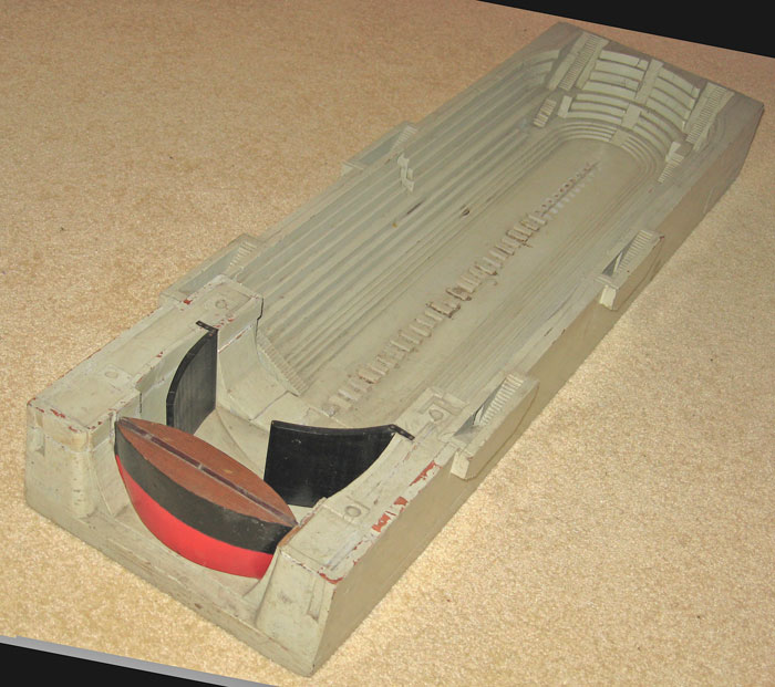
Figure 1. Cyrus Baldwin’s Dry Dock Model With Lock Gates and Caisson Components Shown
Photo by, and used with permission of John Baldwin
In his article Howard indicated that there are commemorative inscriptions cut into the Quincy granite of which the actual Dry Docks are constructed; these would be found in the semicircular portion at the far end of the Dock.
The second part of the model is of the original caisson. In Figure 1, the caisson is the red and black, lens-shaped structure. The remarkably detailed model of it, shown in Figures 2 a & b, below, is quite large, about 8" deep. 16"high, and 32" wide; 1:2:4 proportions.
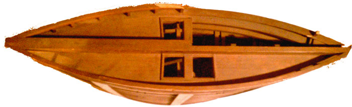
Figures 2 a & b, Model of the Caisson
Top View (a), and Side view (b), with the interior partly exposed
Photo by, and used with permission of James Baldwin
A photo of the actual caisson, floating in the foreground near the USS Constitution, is shown below. The photo was taken around the turn of the century, shortly after the time when “Old Ironsides” had been used as a barracks and about 20 years before the notable ‘children’s pennies’ campaign was conducted to raise money to restore her; a major effort that placed her in the Baldwin Dry Dock for almost three years (June 1927 to March 1930).
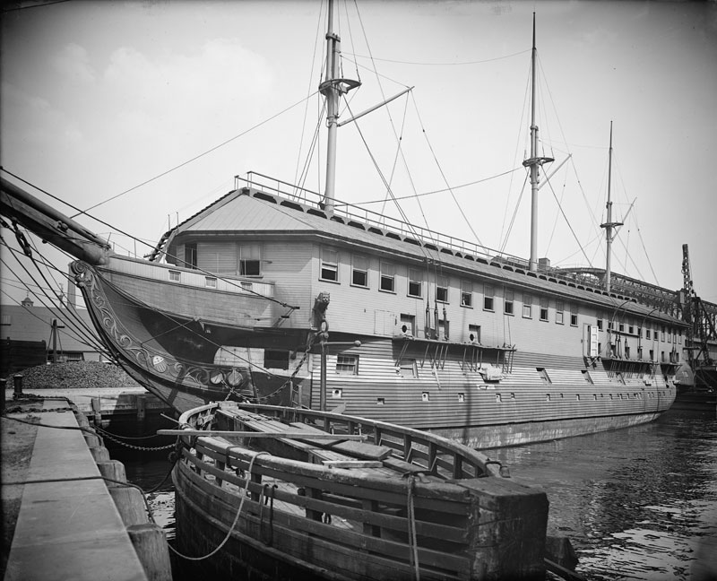
In the context of a dry dock, the caisson was used to seal the open end. Why? Lock gates habitually leak; usually not a lot, but enough that if the integrity of the dry dock depended on them alone, constant pumping would be required. For this reason, once a ship is in the dry dock, the dock must be sealed and then pumped dry so that the ship rests on cradles and workmen have a dry workspace and access to the lower hull. In practice, the dock must be maintained that way for weeks, months, and sometimes even years, until the work is complete. The caisson provides the seal that enables this to be done.
No doubt these models would have been shown to Navy procurement authorities to give them a visual understanding of what the Baldwins proposed to build. But the models may also have been made in keeping with ship building practices of the time; i.e., half-models were made of ships to be built, that were then “cut” horizontally and vertically to produce the lines and station profiles for the actual ship. Although the Dry Dock model was not “cut”, it seems likely that it would also have been used by the Baldwin brothers to validate their design and construction measurements for the final product.
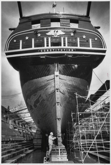
Most recently, in 1992, the Baldwin Dry Dock was again used when “Old Ironsides” underwent a refurbishment. Shown below is a photo of the frigate in the dry dock. The bracing, to keep her upright can clearly be seen along most of the port side, between the frigate and the sides of the dry dock.
A PACKET ON THE MERRIMACK?
by Bill Gerber
The February, 2010, issue of Towpath Topics (http://middlesexcanal.org/towpath/) was largely devoted to describing John Langdon Sullivan’s efforts to develop tow boats powered by steam engines, to move ‘luggage boats’ (freighters) up and down the Merrimack River, and to propagate the concept of towing companies, using similar boats and Sullivan’s business practices, on the navigable rivers of the east coast. More recently, some of Sullivan’s correspondence with a John Vaughan, Esq., in Philadelphia, became known (in the possession of the American Philosophical Society). It appears that Mister Vaughan acted as Sullivan’s agent, to find potential tow boat company clients in the Philadelphia area.
While overall the correspondence elaborates on and somewhat extends what we already knew about some of Sullivan’s efforts, a particular comment, in a proposed advertisement (Ad) accompanying one of the letters, is very curious. The last paragraph of the Ad reads as follows:
“The subscriber who has a patent for the Invention of the passage boat towed by means of a Steam boat which precedes, has established this method of traveling on the Merrimack; and will convey an exclusive right to the use of his Patent on very liberal and easy terms. Application may be made to him for this purpose by letter addressed to him at Boston.”
(My thanks to Debby Fox for the transcription. The italics, above, are mine.)
The correspondence transmitting the Ad dated to July 1, 1817. This was the summer after Sullivan returned his rebuilt and considerably modified 1812 tow boat to service on the Merrimack River (which, in the TT article cited above, I identified as his 1816 boat). A newspaper article noted that the boat employed side-wheels (in place of chain-floats); and a statement Sullivan made in 1818 indicated that the vertical action of his Oliver Evans steam engine was changed to a less self-destructive horizontal action. Beyond this, nothing more was known about this boat.
This short comment in the Ad sheds additional light on the fate of the 1816 boat. It clearly indicates that Sullivan had established travel on the Merrimack by “passage boat” in tow by a steam boat, and the 1816 boat is the only one known to have been available for this purpose at this time.
In contrast to the term “luggage boat”, which implied a “freighter”, the term “passage boat” usually referred to a canal “Packet”, i.e., a boat that carried passengers and light freight. Such a Packet was introduced and maintained on the Middlesex almost as soon as that canal opened; its purpose being to carry the company’s business and communications up and down the canal; and this essential function was funded by carrying paying passengers. This Packet was limited to travel between Beechum’s Landing in Charlestown and Middlesex Village in East Chelmsford (p/o Lowell after 1874). It did not continue on into the Merrimack. But there would have been a need for a similar function along the river canals almost as soon as they opened for business.
Though timber rafts and the occasional boat had been coming down the Merrimack for many decades, freight boats only began routine operation, up the river as well as down, between Chelmsford, MA and Concord, NH in 1815. This had been made possible by the construction of bypass canals around, or opening “improvements” through, the Merrimack’s many falls and rapids. Once the freight began to move, could the need for passenger transportation service not be far behind? Sullivan’s statement indicates that a Packet, likely towed by the 1816 towboat, is the means by which this need was first met.
That Sullivan initiated this service raises another research question: is there any relationship between Sullivan’s endeavor and the launching of the steamboat Herald in 1834? Measuring 90 feet long, 20 feet wide and drawing three feet of water (thus too large to pass through any of the Merrimack locks above Chelmsford though, at that time and in that configuration, it could have passed through the locks of the Pawtucket Canal) the Herald carried passengers between Lowell and Nashua, typically making two trips each day. Was it placed in service based on the success of Sullivan’s initiative? (The Herald’s service was short-lived, the railroad reached Nashua in 1838, bleeding off most of its customers. Subsequently the Herald was lengthened by 30 feet and operated for a while as an excursion steamer.)
All of which suggests that there may well be a new set of clues to look for to clarify and elaborate on this still rather sketchy story.
Notes:
1 American Philsophical Society, Misc. Mss. Coll., 1814 July 6, J. L. Sullivan, “Concerning Steam Boats.”
2 Lowell Sun , May 31, 1955, p-7.
A BOAT LOAD OF CORDWOOD & A MYSTERY
by Bill Gerber
The photo, below, was recently purchased by a descendant of Colonel Loammi Baldwin, chief engineer of the Middlesex Canal. The new owner stated (partially paraphrased): ‘It is an enhanced scan of a print purported to be of a canal boat on the Middlesex Canal. The original is in very rough shape and has nearly faded completely away. It is labeled “the old Middlesex canal” in pencil in a handwriting style that strikes me as early 20th century. I performed a contrast stretch on it to make it a little easier to see. I have no provenance for it nor any way to confirm that it is the Middlesex Canal. I would like to compare the image to the route of the canal to try and see if I can match it up to a known location with a hill and cut as seen in the image.’
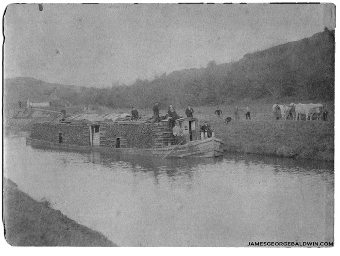
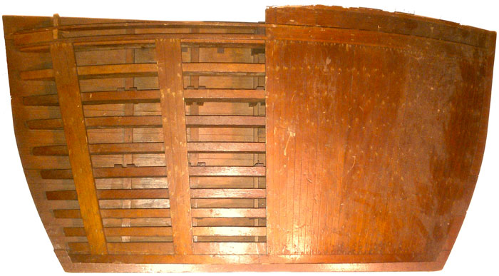
I’m fairly convinced that the photo is not of a Middlesex Canal boat. If it were, it would be one of only three that I’ve ever seen in 35+/- years of looking; and the others were probably taken decades after the canal was abandoned.
The boat in the photo is not of a form consistent with those thought to have operated on the Middlesex Canal. In all the graphics I’ve seen (just drawings, no photos), artists have always depicted our Middlesex Canal ‘luggage boats’ (freighters) as primitive, double-ended ‘scows’. The provenance of this perception is not well documented, however, all artists to date have drawn them this way, and the one vintage drawing that I have, of a luggage boat, drawn to scale by George Rumford Baldwin in about 1829 (shown below), is consistent with it, but with “softened corners” bow and stern.
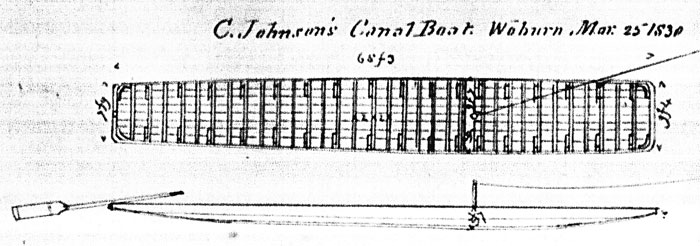
Middlesex Canal Luggage Boat
Why not the Middlesex? (a)To the best of my knowledge, our boats were more primitive - i.e., essentially double-ended scows. This, of course, is a boat of more sophisticated construction. I am unaware that any such freight boats operated on the M’sex (though I cannot say for certain that they did not). (b) Tom Raphael (lifetime engineer with patents to his name) scaled the size off from some assumed references and believes that the boat is considerably too large for the Middlesex Canal Locks. (c) Reinforcing Tom’s assessment, if one assumes that cord wood is typically cut in 4' lengths, then it would be quite difficult to build a shelter in the middle of a Middlesex Canal canal boat, as obviously was done with the load in the photo. (d) the Middlesex Canal recorded its last toll in November, 1851, and the last known boat to pass through was in April of the following year. Though not impossible, photographic technology was not well developed by that time, so it seems very unlikely that this photo could have been taken before the Middlesex closed.
Assuming that this is not a photo of a Middlesex Canal canal boat, on whose canal was it taken? An article similar to this will be published in a forthcoming issue of American Canals, newsletter of the American Canal Society, asking the same question. Let’s see if anything comes of it.
The one response that I’ve had thus far, to the publication of the foregoing article in “American Canals” (newsletter of the American Canal Society), was from Dave Barber, President of that organization. Dave reasoned - “Why do you think that you are looking at the towpath behind the boat? Tom’s analysis is that the towpath is 10' above the waterline. But, maybe the towpath is in the left foreground. In that case, we have no idea as to its height. The usual practice was to load on the berm side, keeping the towpath clear. If this boat has just been loaded, or is just tied up, it should not be on the towpath side.” If this is as Dave suggests, then the people and oxen on the far shore (berm side) might include those who brought cordwood to be loaded and/or be part of the loading crew. Good points!
MISCELLANY
Estate Planning - To those of you who are making your final arrangements, please remember the Middlesex Canal Association. Your help is vital to our future. Thank you for considering us.
Web Site - As you may have noted from the mast-head, www.middlesexcanal.org is the URL for the Middlesex Canal Association’s web site. Our web master, Rob Winters, keeps the site up to date, thus events and sometimes articles and other information will sometimes appear there before we can get it to you through Towpath Topics. Please do check the site from time to time for new entries. Also, the site now contains a valuable repository of historical information, all of the back issues of TT, and an index to all of the articles contained therein, can now be found there at middlesexcanal.org/towpath/.
Museum & Reardon Room Rental - The facility is available at very reasonable rates for private affairs, and for non-profit organizations’ meetings. The conference room holds up to 60 people and includes access to a kitchen and rest rooms. For details and additional information please contact the museum at 978-670-2740.
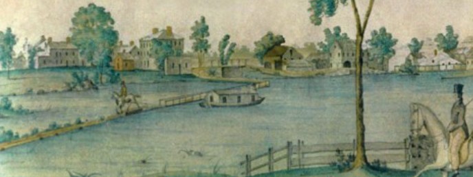
Nameplate - Excerpt from a watercolor painted by Jabez Ward Barton, ca. 1825, entitled “View from William Rogers House”. Shown, looking west, may be the packet boat George Washington being towed across the Concord River from the Floating Towpath at North Billerica.
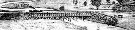
Back Page - Excerpt from an August, 1818, drawing (artist unknown) of the Steam Towboat Merrimack crossing the original (pre-1829) Medford Aqueduct.
Canal Game and Puzzle - The National Canal Museum has made a canal related game and a puzzle available on their web site www.canals.org/funandgames/. These include: a Boat Captain’s Game - Can you run a canal shipping business successfully? And a Canal Lock Puzzle - would you know how to construct a canal lock and make it work? Give them a try.
Towpath Topics is edited and published by Bill Gerber and Robert Winters.
Corrections, contributions, and ideas for future issues are always welcome.