
Middlesex Canal Association P.O. Box 333 Billerica, Massachusetts 01821
www.middlesexcanal.org
| Volume 52 No. 1 | September 2013 |
MCA ACTIVITIES
Please mark your calendars.
The Fall bicycle tour of the canal, north from Charlestown, will occur on Saturday, October 5th.
The MCA-AMC Fall Walk will take place in Woburn on Sunday, October 20th.
Our Fall Meeting will be held on Sunday, November 3rd, 2013, in the museum, beginning at 1PM. Our speakers will be Bob and Linda Barth to tell you about the Delaware & Raritan and the Morris Canals of New Jersey. Refreshments will be served.
See the Calendar, following, for more information on our activities. Also included in the calendar are meetings and tours, sponsored by other canal and related organizations, in which you may want to participate.
Please also check our web site now-and-then, at the URL noted in the nameplate, above, which also lists canal-related events and topics of potential interest, sometimes including those that don't make it into Towpath Topics.
If you can say Welcome!, you can be a volunteer at the museum. Simply come to the museum prepared to greet visitors at the reception desk. An experienced docent will be present to answer questions.
PRESIDENT'S MESSAGE
by J. Jeremiah Breen, jj@middlesexcanal.org
The mile of canal between Gray and Pond Streets in East Billerica has been changed by the owners of the land after the dissolution of the canal company. The first change was probably the building of the 1877 Canal House at 52 Gray St, built to house the workers at the nearby factory which used Content Brook for waterpower. See http://www.jstor.org/stable/529808 The width of the house lot is 300', the width of the canal company's land. And yes, the canal did go right down the middle, but now the ~5' high walls of earth of the towpath and berm end where the house lot begins.
After Tomahawk Street was developed in the 1980s off of Pond St, the towpath was buried under fill for 1/6th mile, making what was a 10' wide path now a steep slope. Halfway between Gray and Pond, a property owner has removed an ~10' length of towpath, simply dug it out with an excavator, to allow the wetland on his property to drain into the canal and to discourage ATVs from traveling on the towpath. The nearby waste sluice from the canal to Content Brook, which drains into the Shawsheen, is open. Drainage should be good as the water level in the canal was 27' above the water in the Shawsheen River when George Baldwin measured the difference in 1830.
Another property owner has blocked with brush the route ATVs used to travel between the towpath and Tomahawk. The ATVs have made a new route along what looks like a town drainage easement from Tomahawk to the canal with a culvert under the towpath.
The lots south from the towpath to Salem Road are very long, 2000' ±. When the owner of 282 Salem subdivided to make a house lot for his daughter's family, his and his daughter's lot used 700' and 3.4 acres. The remaining land, 9.1 acres, he gave to the Association. Marlies Henderson, a proprietor, has flagged a walk from the canal to the 25'-wide easement which provides access to the Association land from Salem Road. The easement is more or less the daughter's driveway.
Marlies has sought permission from the US Environmental Protection Administration to walk at the edge of the Superfund site on the 107-acre Shaffer property, the south boundary of which is the towpath, with the following 7/24/2013 response:
Hi Marlies,
Sorry for the delay in responding to you. I do recall our conversation earlier this year.
While I have not looked at parcel/lot maps in some time, but my recollection is that the property south of the Canal is all privately owned by the various homeowners along or off of Tomahawk Dr. I think that the path is at the "back" of those various properties. The path is not "inside" the landfill fence, or on property controlled by either the PRPs or EPA.
So, the bottom line is that EPA does not have the ability to grant or deny access to that area.
As an anecdote, I don't recall anyone challenging me doing times that I walked the path. I did it many times, though it has been a few years since the last time.
PRPs are the Potentially Responsible Parties. The attorney for the PRP Group emailed on 4/24/2013 as follows:
Mr. Breen
I have your note.
As Sol Feldman may have relayed to you, the ability to access the Graypond property and the extent to which and circumstances under which Mr. Shaffer and his brothers may grant access to the former landfill property may be limited by the terms of the Consent Decree to which my clients, the Shaffers, individually, the EPA and the Massachusetts DEP all are parties. While the PRP Group, which I represent, will review your note and respond substantively, I suggest that MCA contact Donald McElroy of the EPA to determine whether the government considers the proposed property use consistent with the condition of the site.
Let me know if you have questions.
Best,
Rob
Sol Feldman is the attorney for Graypond Realty. Color emphasis was in Marlies' email to EPA.
While Marlies has sought permission to walk on the towpath, the MCA is seeking an easement on the Shaffer property at its south boundary, i.e., permission to walk on the berm. When the owner of the land on both sides of the canal sold that north of the canal, the dividing line was at the waterside of the towpath except for the 300' square of the 1877 Canal House lot. The towpath has been built on, buried, and excavated. The berm is safe from development. Under the consent decree for the Superfund site, it is under the control of the US Government for forty years, and then, if certain conditions are met, under the control of MassDEP. As the boundary of a Superfund site, the berm is taboo.
Marlies and husband Brian might lead a walk over the towpath and Association land this fall. If you want to be notified of the walk, a request to jj@middlesexcanal.org will do it. For more information on Gray-Pond, http://middlesexcanal.org/towpath/towpathtopicsMar2012.htm.
J. Jeremiah Breen
TABLE OF CONTENTS
MCA Activities
President's Message (J.J. Breen)
Calendar of Events
For Future Planning
The 1825 Iron Bolt (Breen)
New at the Museum (Gerber)
"Bewitching Ditch" (Seaburg)
Extract from: The Symmes Memorial (for Vinton)
History of Middlesex Canal in Local Woods (Hall)
Bridge Plaque (Gerber)
Future Publication – A Question (Gerber)
A Reminder
Canal Boat Rides (ACS)
National Canal Museum & Heritage Corridor to Merge
Middlesex Canal Stock Certificates
Miscellany
CALENDAR OF EVENTS
Middlesex Canal Association (MCA) and Related Organizations
First Wednesday - MCA Board of Directors' Meetings - The Board meets at the Museum, from 3:30 to 5:30pm, the first Wednesday of every month, except July and August. Members are always welcome to attend.
Directions to the Museum/Visitors Center: Telephone: 978-670-2740.
By Car:
From Rte. 128/95, take Route 3 toward Nashua, to Exit 28 "Treble Cove Road, North Billerica, Carlisle". At the end of the ramp, turn left onto Treble Cove Road toward North Billerica. At about ¾ mile, bear left at a fork. After another ¾ mile, at a traffic light, cross straight over Route 3A. Go about ¼ mile to a 3-way fork; take the middle road, Talbot Street, which will put St. Andrew's Church on your left. Go about ¼ mile and bear right onto Old Elm Street. Go about ¼ mile to the falls, where Old Elm becomes Faulkner Street; the Museum is on your left and you can park across the street on your right, just beyond the falls.
From I-495, take exit 37, N. Billerica, south to the road's end at a "T" intersection, turn right, then bear right at the Y, go 700' and turn left into the parking lot. The Museum is across the street.
By Train: The Lowell Commuter Line runs between Boston's North Station and Lowell's Gallagher Terminal. Get off at the North Billerica station, which is one stop south of Lowell. From the station side of the tracks, the Museum is a 3-minute walk down Station and Faulkner Streets on the right side.
Sept 14-28 and Oct 12-26 - The Canal Society of New Jersey Fall Season: Waterioo Village will be open to the public for Heritage Days on the Saturdays noted.
Sept 16-19, 2013 - World Canals Conference in Toulouse, France, along the Canal du Midi, with accompanying excursions prior to and following. See inlandwaterwaysinternational.org/world-canals-conference or wcc13.com/en for details.
Sept 20-22, 2013 - The Canal Societies of Indiana and Ohio - Fall Tour on the Wabash & Erie Canal, and Delphi's Canal Park and Trails. Based at the Comfort Inn in Lafayette, IN (765-447-3434); tour the Tippecanoe Battlefield; ride the replica canal boat "Delphi"; tour the historic canal town, its museum, many restorations and environs. Trip planners: Dan McCain, Mike Morthorst, Brian Stirm, and Bob & Carolyn Schmidt. Contact: indcanal@aol.com.
Sat, Oct 5, 2013 - Bicycle Tour of the Historic Middlesex Canal. MassBike, the Somerville Historic Preservation Commission, the Middlesex Canal Commission and the Middlesex Canal Association will sponsor the 13th annual bicycle tour of the canal which was the "big dig" of late 18th century Massachusetts. Completed in 1803 after 10 years of construction, the Canal connected the Merrimack River, west of what is now Lowell, with the Charles River at Sullivan Square in Charlestown. The Canal provided passenger and freight service for 50 years. It pioneered many innovations and in many ways served as a model for later canals, notably including the Erie Canal.
We will meet at 9:00AM at the Canal marker on the Sullivan Square MBTA station. From there we will ride about 28 miles to the Mill Village and Canal Museum by the Concord River Millpond in North Billerica. We'll stop for lunch in Woburn, so please bring a lunch. We should get to North Billerica in time for anyone who wants to catch the 3:07PM train back to Boston.The ride will then follow the northern section of the Canal another 10 miles to Lowell in time to catch the 5:00PM train back from there.
The ride will be an easy one for most cyclists; the route is pretty flat and we will average 5 miles per hour. Along the way we will stop at: several canal remnants and restored sections; the Mansion of Loammi Baldwin, chief engineer for the Canal (for whom the Baldwin apple is named, discovered during an early canal survey); the two remaining aqueducts (which carried the Canal over rivers and brooks); and the northern end of the floating towpath that enabled horses to tow boats across the Concord River.
The ride will be led by Dick Bauer of the Somerville Historic Preservation Commission and the Middlesex Canal Commission, Robert Winters of the Middlesex Canal Association, and Bill Kuttner of the Shirley-Eustis House. Steady rain cancels.
For more information, contact Dick at dick.bauer@alum.mit.edu (617-628-6320); Robert at robert@middlesexcanal.org; or Bill at bkuttner@ctps.org (617-973-7132). For more information about the Middlesex Canal go to: http://www.middlesexcanal.org, &/or http://www.massbike.org/resources/rides.htm.
Oct 18-20, 2013, Pennsylvania Canal Society - Fall Field Trip - Union Canal from Middletown to Reading including a tour of C.Howard Hiester Canal Museum, which shares the story and history of the Union and Schuykill Canals. Contact Bill Lampert (indnbll@yahoo.com) and www.pacanalsociety.org for more information.
Oct 18-20, 2013, Canal Society of New York State - Fall Meeting, Eastern Mohawk. Based in Schenectady the tour will examine the storm and flood damage in this area of the Erie Canal. See www.newyorkcanals.org for more information.
Sun, Oct 20, 2013. Joint MCA-AMC Fall Middlesex Canal Walk, Woburn. Meet at 1:30pm at the the SE corner of the parking lot behind the Woburn Cinemas, along Rt. 128. Level, 3-mi., joint walk w/Appalachian Mountain Club along 2 sections of the historic canal. From Rte. 95/128 exit 35 in Woburn, take Rte. 38 S 0.1 mi., R onto Middlesex Canal Dr. past the Holiday Inn to the meeting place. Info: www.middlesexcanal.org. Phone 1-978-670-2740. L Robert Winters (617-661-9230; robert@middlesexcanal.org), CL Roger Hagopian (781-861-7868 to 10pm).
Sat, Oct. 26, 2013, Chesapeake & Onio Canal Society - Annual Heritage Hike. Evening dinner and program to follow. Details will be in September newsletter. Contact Marjorie Richman at programs@candocanal.org.
Sun, Nov 3, 2013 - MCA's Fall Meeting will take place in the museum, at 1:00PM. Our speakers will be Bob and Linda Barth who will tell us about the Delaware & Raritan, and the Morris, the two principal canals of New Jersey. Refreshments will be served.
One of our nation's most successful towpath canals, the Delaware and Raritan has meandered across the narrow waist of New Jersey for more than 170 years. In 1866 it carried more tonnage than the more famous Erie Canal. The D&R transported men and supplies between New York and Philadelphia during three wars, and now provides the people of central New Jersey with both a water supply and a premier recreational facility. Author of many canal and travel articles, historian and frequent tour guide, Linda J. Barth will introduce you to the people, the bridges, the locks, and the aqueducts that made the canal work.
Complementing his wife, past CSNJ President Bob Barth will provide a virtual tour of the Morris Canal. One of six towpath canals built to carry eastern Pennsylvania anthracite coal to market, the Morris connected Phillipsburg on the Delaware River with New York Harbor, opening in 1831 to Newark and in 1836 to Jersey City. A unique engineering marvel, this 102 mile canal crossed the Highlands of New Jersey, overcoming more change in elevation than any other transportation canal ever built. Most of the elevation changes were accomplished through the use of 23 inclined planes, on which canal boats were carried up or down long and steep ramps on plane cars, i.e., open-ended cradles, that ran on rails.
2014 - World Canals Conference, Navigli Lombardi, Milan, Italy
FOR FUTURE PLANNING
Tentative Dates for the Winter and Spring MCA activities are as follows:
February 9, 2014 - Winter Meeting
April 6, 2014 - 12th Annual Bike Tour, South-bound, starting at 9:00am
April 20, 2014 - MCA-AMC Spring Walk, TBD
May 4, 2014 - Spring Meeting, 1:00pm at the Museum
These dates may change slightly based upon the personal schedules of trip leaders and speakers. Please check our website a few weeks before for any changes.
THE 1825 IRON BOLT AND THE GREAT BILLERICA DAM CONTROVERSY
by J. Jeremiah Breen
The farmers who owned the Concord and Sudbury River meadows sought to have the dam at Billerica Falls removed. The granite dam, 128' long, 8' high, 5' wide crest, had been built in 1828 by the Middlesex Canal Company, 10' down river of the company's 1798 dam which had replaced a 1711 dam older than the canal company. The farmers had long claimed their meadows were damaged by floods backed-up from the dam, but the 1793 law which incorporated the company blocked a claim for damages being presented to a jury, unless brought within a year.
 Owners of the Sudbury and Wayland meadows, more than sixteen miles up river from the dam, were particularly aggrieved, claiming they could hardly know within a year that a change at the Billerica Falls had changed the effect of weather variable floods on their meadows. With the dissolution of the canal company in the 1850s, the farmers again renewed their claims against the then owners of the dam, the Talbots.
The legislature in 1859 commissioned five of its members to inquire into the flooding. The report of the commission was published in January 1860 (now available as a 517-page PDF at Google Books (tinyurl.com/Jan1860report). The commission reported that the dam was a cause of the flooding. The legislature revoked the privileges granted with the 1793 incorporation and ordered that the dam be lowered. The Talbots resisted. The legislature then commissioned a lawyer and two engineers to report on the effect of the dam on the Concord and Sudbury meadows. After more than 35,000 measurements of the water levels in the rivers and meadows at varying river flows, this second commission report was published in January 1862 (now available as an 128-page DjVu at the Internet Archive (tinyurl.com/1861shedd).
Many of the hundreds of pages of testimony in the first report were on how great the damage was from the higher 1828 dam with its 9" flashboards than from previous dams. The legislature deemed that the 1828 dam should be 33" lower. The second, or engineers', report, did not use testimony from the protagonists and their experts, just the scientific method of experiment with thousands of measurements, and concluded that the dam did not cause the flooding. The legislature repealed the order to lower the dam.
As a consequence of the Billerica Dam controversy, a trove of information on the canal at its highest elevation, the summit pond, has been passed down in the testimony of the workers on the canal and in the work done by the experts.
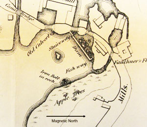
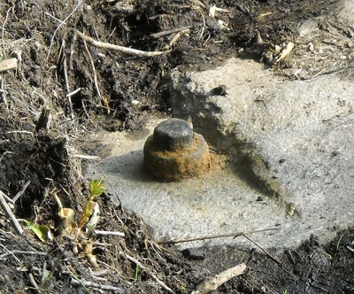 The benchmark for the measurements was an iron bolt.
"I remember a bolt being put in at the Dam, to regulate Capt. Faulkner's height of water. I was told to put it in, by Col. James Baldwin. He was Agent of the Canal, at the time it was put in, and it was put in for purpose of regulating the use of water by Esquire Faulkner. I put it in." (December 16, 1859, testimony of Daniel Wilson, age 69, remembering 1825.)
Bolt diameter, 2-9/16" ± 1/16", measured in 2010.
The elevation of the bolt top is 109.64', Sea Level Datum of 1929 (NGVD29), measured in 2013 from a temporary benchmark set in 2000 from the 1965 U.S. monument, MY0308. The 1861 engineers reported "The bolt is 115.35 above the Boston base, or mean low water in Boston Harbor." The Boston City Base - 5.65' = NGVD29, or specifically, 115.35 - 5.65' = 109.70'.
"We had to let the water in according to the length of the level, on the respective sides. It was not as necessary to use as much water on the West side as the other. We had a mark which we kept the water up to." -- Daniel Wilson.
The elevation of water in the canal was maintained by opening the paddle gates enough to maintain the elevation up to a mark with the canal east of the pond taking three times the flow of the west. Wilson's testimony didn't include the location of the marks in plan or profile. (James Baldwin, agent of the canal company in 1825, identified Wilson as the foreman at Billerica. Wilson's daughter was a daughter-in-law of the Faulkner who owned the mill when he testified.) Unfortunately, Wilson didn't give the connection between the marks and the iron bolt.
George Rumford Baldwin did a survey of the canal from the Charles River to the Merrimack in July, 1830. In drawing the canal profile, Baldwin used the lock gate sill elevations for the bottom of the canal in the different canal levels. In drawing the water surface, he apparently scaled up from the sill elevations more than the design depth of 3½'; but the scaled depth as drawn varied enough when re-scaled in 2013 that the depth intended is not ascertainable. The location of Wilson's marks for the water level in the canal can not be determined from the 1830 drawing.
Baldwin testified on December 19, 1859 about the 6½' height of the dam as measured by his brother Loammi in 1811. If he listened to the witnesses testify about the iron bolt and the height of the dam or read the pages of testimony in the January printed report, he would surely ask himself, why didn't I put an elevation on the Middlesex Canal Dam? Unfortunately, Baldwin did not use either the iron bolt, the locktenders' marks, or the granite dam in his 1830 survey.
"I recollect the top of the stone sill on the east side was 4 ft. 2¾ inches below the top of the flash board. The top of the wood sill was 5 ft. The difference is 9¼ inches." Warren Nixon, surveyor, testifying October 14, 1859, describing measurements done that month.
Fortunately Baldwin did put elevations on the sills Nixon would survey twenty-nine years later. The elevation of the sill on the east side of the summit pond was 109.25', that on the west, 108.48', difference 0.77', or 9.24 inches. Therefore, as the flash board is even with the iron bolt, Baldwin 1830 – 3.84 = NGVD29. With the Baldwin datum now tied to a standard, the Sea Level Datum of 1929, the mark used by Wilson to regulate the water level on the west side can likely be found.
Part of the guard lock on the west side had been used as a channel supplying water to a Talbot Mill turbine which has kept it intact more than a century-and-a-half until today. The approximate horizontal location of Wilson's mark will be on the wall of the lock, downstream of the miter gate, near the handle of a paddle gate. The vertical location is el. 109.14' ±1', NGVD29, based on 4.5' added to the sill elevation.
When a utility trench crosses the canal, the utility is required to hire an archaeologist to document the crossing with a report to the State Historical Preservation Officer. In the past, archaeologists have reported that something was found a specified distance below ground. Now archaeologists can also report with respect to the canal bottom.
NEW AT THE MUSEUM
by Bill Gerber
We've long wanted to provide visitors with some sort of guide to the various exhibits in our Middlesex Canal Museum. Unfortunately, our's is not a wealthy establishment, and so the type of device that you might find at the Museum of Fine Arts or other top museums was quite unaffordable for us.
Technology to the rescue! MCA VP Traci Jansen has been working to make this a reality, and her approach is quite "state-of-the-high-tech-art".
If you've visited the museum lately you may have noticed small purplecolored 'code-blocks' adjacent to many of the exhibits items. Called QR codes; they look a bit like tiny unworked crossword puzzles. Though hard to tell, each code is a little different and thus is unique to each exhibit.
The way Traci is using them is - when you scan a code with a smart-phone or equivalent device (iPad, iPod, Surface, etc.) containing a QR reader application (app), you are immediately linked through the Internet to a 'file in the clouds', somewhere (who knows where), that provides streaming audio to your device. By this means you can listen to Traci telling you about that specific object.
There are a number of technologies available that could be used to accomplish this. Traci is using "SoundCloud", you can read more about it at https://soundcloud.com/.
Longer term, if combined with a photo of the object, the narratives could provide a foundation for the creation of a Virtual Tour of the museum which then could be placed on-line, thereby giving interested parties everywhere access to information about our canal. (And if this is a project that interests you, and you'd like to work on it, it just might make it to fruition considerably sooner. Please do talk to us about your interest.)
"BEWITCHING DITCH"
by Alan Seaburg
Book Review: Deep Travel In Thoreau's Wake on the Concord and Merrimack by David K. Leff, University of Iowa Press, 2009
Before he retired David Leff was the deputy commissioner, Connecticut Department of Environmental Protection, where he oversaw conservation programs dealing with parks, forests, fisheries, and wildlife. In this interesting retirement journey he follows the 1839 trip of the brothers Thoreau on the Concord River, Middlesex Canal, and Merrimack River. His several trips thereon were done by canoe with various family members. They were made by what he calls "deep travel," which means to him that the journey was not to just get somewhere but to do so by reflecting as they canoed upon the changing and evolving history and life of the area traversed. Or as he puts it, "Deep travel is an ecological way of looking where everything we see had a function and all the parts are related, no matter how seemingly disparate or contradictory."
This review focuses on just the chapter directly dealing with the "bewitching" Middlesex Canal, although clearly material on the Merrimack River in New Hampshire and on its confluence with the canal in the old mill city of Lowell have much to interest the members of the Middlesex Canal Association (MCA).
As did the two Thoreaus, Left set off from Concord and spent the first evening in the general area of the Route 3 Bridge in Billerica not too far from where Henry and John spent the first evening of their adventure. The next morning he and his companion paddled their canoe to our familiar North Billerica Millpond, dam, Talbot and Faulkner mills. This was the point where the canal builders first started digging the Middlesex and where the water of the Concord flowed into the old canal.
There they stopped for lunch and to investigate the stone dam, the river flowing under the street to come out "frothing over rocks and ledges," the mills, and our museum. Here the author's first trip ended for while the Thoreau brothers were able to reached the Merrimack via the Middlesex Canal he knew that was no longer possible for much of the canal today "has long been obliterated, paved, or filled. Even where a section remains and retains water, it has been reduced to a shallow, linear swamp." So the travelers went home to return another day with a pickup and used that to get to Lowell but traveled there by a route as close to the old canal as was possible.
During the canal part of the trip Leff had to guide him two familiar MCA publications: The Old Middlesex Canal by Mary Stetson Ckarke and Middlesex Canal Guide and Maps by Burt VerPlanck. For further information and details he consulted the staff and the archives of the Billerica Public Library.
The books were handy to their explorations helping them to identify many things; for example, some small holes in the granite blocks at the "concrete apron at the Talbot Mill" which they learned were part of a lock. And when they went up Lowell Street his companion was able to tell him that the firehouse there "was built over an old canal basin." In addition, his visit to the Canal Museum with its various exhibits, murals, paintings, historical documents, and archives allowed him to properly "feed" his imagination. "Photographs we had viewed, descriptions we had read, and artifacts we had seen allowed us to experience not just rocks, trees, soil, and a halfpipe depression of murky water, but a logical argument [the canal] laid out in the countryside."
One does wish, however, that he had mentioned that the canal had a Floating Towpath with its still existing "anchor stone" on the Concord River Millpond. Also that the MCA provides its members and the public three free historical lectures a year as well as two annual canal walks, one in Spring and one in Autumn.
About the canal itself, he writes, that it was "a little more than twenty-seven miles long with twenty locks and eight aqueducts." As such it was "a transportation marvel and an engineering conquest of topography in the uneven Massachusetts landscape, with its hills and swamps, ledges and streams" and was "built by the sweat of men wielding shovels, picks, and wheelbarrows and gunpowder to blast ledges." Further, he directly experienced the canal of today. For example at one point he left the pickup to descend into "a ditch of shallow water" and then climbed up to the towpath to view the canal now reduced to "a wide, elongated wetland, dank with green algae" and "clumps of yellow iris" in bloom. More significantly he also glimpsed a bit of the canal's tomorrow including its recreational trails, bike paths, and boating.
The book has much more to offer than a review can cover. Those interested in the Merrimack River which, if not the Middlesex Canal is certainly a vital member of its extended family, will find much to enjoy in the chapters describing that part of the trip. And if a college or university were to offer a course on traveling these rivers and the canal since the days of the Thoreau brothers this volume along with similar books by John McPhee, Ann Zwinger/Edwin Way Teale, and Raymond Mungo/Verandah Porche would find a place in the bibliography of its syllabus.
EXTRACT FROM: "THE SYMMES MEMORIAL" (1873)
By John Adams Vinton
Printed for the author [JAV] by David Clapp & Sons
In 1793, a plan was formed by some enterprising citizens of Medford and other towns in the vicinity, for a canal to connect the waters of the Merrimack, at Chelmsford, with the tide water of the Mystick River, near Boston. A company formed for this purpose which was incorporated by the legislature, June 22, 1793, by the name of "The Proprietors of the Middlesex Canal". Some years were spent in surveying and in other necessary preparation so that it was not navigable till 1803.
This canal was, at the time, regarded with much favor and promised to be of great public utility. But it cost a great deal of money. One hundred assessments were made between Jan 1, 1794 and Sept. 1827 - the whole amount being $1,164,200, or $1,455.25 on each share. [True??] The first dividend was not declared 'till Feb. 1, 1819. From that time it yielded an income of less than one and a half per cent per annum. The construction of the Boston & Lowell Railroad, in 1835, utterly ruined its business, and in 1952 its charter was surrendered and the canal sold by auction.
On the 17th of October, 1801, Capt. Symmes conveyed by deed a certain portion of land to the Proprietors of the Middlesex Canal, the canal passing very near it, He afterwards sold to them another portion. A bill of his now before me is for business done for the canal, in 1818-20, especially in carting materials and machines to and from Boston. Among these were steam engines to be used on the canal, as early as 1819.
Mr, John L. Sullivan, of Boston, was agent for the canal, though a part of the business transacted by him was on his own private account. In 1800 or 1801, Mr, Sullivan purchased of Josiah Symmes, brother of Capt, Symmes, his share of the mill and mill-privilege, being three-fourths of the same, which had come to him from his grandfather, William Symmes. Soon after this Mr, Sullivan and Capt. Symmes built a new mill-dam, which considerably increased the water fall, raising it to six feet. It flowed the land above, and interfered with the operations of the grist-mill higher up the stream, then owned by Abel Richardson, Several lawsuits with Richardson and others followed, continuing ten years or more, which were not finally settled till 1820 or later. These suits were decided against Sullivan and Symmes.
Mr. Sullivan was an enterprising man; he now owned three-fourths of the mill privilege and, at length, in 1823, Jan 6, the other fourth part, hitherto owned by Capt. Symmes, was conveyed to him (Symmes) for one thousand dollars to William Sullivan, of Boston, and Richard Sullivan, of Brookline, to whom their kinsman, John L. Sullivan had, in February, 1820, conveyed his part of the premises.
In 1801, or soon after, Capt. Symmes built a grist-mill at the eastern extremity of the milldam. The premises now conveyed by him were "my grist-mill and all the rights, privileges and appurtenances thereof; and all the right, title and interest which I have in the land, buildings, dam privilege of flowing and using water on Symmes River, in Medford, my right and interest in the property being estimated at one-fourth part thereof".
The mill and mill-privilege had never passed out of the possession of the Symmes family 'till 1823, since the country was settled, one hundred and eighty years.
Mr. Sullivan was somewhat given to scheming. The Middlesex canal was under his superintendence, and he on his own account made steam engines at the factory on "Symmes's River," to be used for propelling boats on the canal. The manufacture of wood screws by a newly-invented machine was also prosecuted, Mr. Sullivan became involved, the whole enterprise failed, and at last he sold the whole establishment for four thousand dollars to Abel Stowell, a son-in-law of Capt. Symmes, who disposed of it to Robert Bacon, hatter, of Boston. Mr. Bacon carried it on for several years, and left it at his death to his children who now possess it. For a time it was known as " Baconville.
Elizabeth Symmes, sister of the preceding, born April 10, 1787; married Abel Stowell, 1814, son of , of Worcester, a noted Clock-maker. His home, after marriage, was in Charlestown, where he carried on the business of a jeweler, He purchased of John L, Sullivan, for four thousand dollars, the mill privilege on the Aberjona River, in the present town of Winchester, which had, from the settlement of the country till 1823, been, partly at least, in the possession and occupancy of the Symmies Family, He had on this stream an iron foundry. After some years, he sold it to Robert Bacon, hatter, of Boston, and it is now in the possession of Mr. Bacon's children.
HISTORY OF MIDDLESEX CANAL IN LOCAL WOODS
By Dan Hall, Crier Correspondent
Posted: Thursday, May 9, 2013 11:02pm
WILMINGTON - The Middlesex Canal used to be the major transportation byway for materials being shipped north from Boston or south to the state capital. Through its level and calm waters, the granite that is found in New Hampshire glided down to Boston to became the stuff of the city, and developing communities north of Boston received materials to grow and develop. Wilmington features prominently in the history of this waterway, with its flat features and essential location between Boston and the northern part of the state making it an integral part of the canal system.
These waterways have long since dried up, and many people do not know the history of the canal, or Wilmington's role in its story. On Sunday, May 5th, the Middlesex Canal Association, sponsored by the Appalachian Mountain Club, put on a nature walk to trace the old canal through a section of Wilmington. About seventy people came to participate in this piece of history, walking off into the woods of 759 Main Street near the Woburn Line to examine the aquatic highways of our forefathers.
The leader of this trip, Robert Winters, is a long time canal enthusiast who has been a member of the Middlesex Canal Association for many years. Winters told the group about the importance of the canal, and how it was a bustling highway in the times before automobiles. "It could get pretty crowded on the canal. Sometimes faster shipments would come by and pass the slower ones."
The canal is now a deep depression in the ground, complete with vegetation and in some cases sizable trees growing out of it. The water, which was only three and a half feet deep at the time of the canal, is long gone. However, the impressive construction of the canal is still present, as are some archeological evidence of its existence.
"This stone wall was built by laborers who carried it here in wheelbarrows and sometimes by hand. This was not easy work!" said Winters.
A stone along the path way had deep cuts worn into its side. "This is the stone that the ropes tied to the horses, who pulled the rafts on this side channel, would have rubbed against. You can see the deep creases from their ropes" said Winters.
The walk concluded at a friendly neighbor's house, where cookies and refreshments were served. The Middlesex canal runs from the Merrimack River down to Charlestown. Anyone who is curious about the canal's history is encouraged to visit the Middlesex Canal Museum in Billerica, MA.
THE BRIDGE PLAQUE
by Bill Gerber
MCA member Millie A. once 'beat up on me' to clean up the Middlesex Canal bas relief sculpture in a plaque on the Hunt's Falls bridge in Lowell. The first time Millie mentioned the plaque she drew a complete blank from me, I'd never heard of it. But she was correct; shown here, the plaque was emplaced during Gov. Volpe's administration, when the bridge was dedicated. The sculpture on it showed two horses, harnessed in tandem, towing a loaded canal boat past several homes in a village.
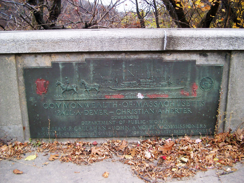
Dedication Plaque, Hunt's Falls Bridge, with Middlesex Canal Bas Relief
Recently, a course I'm taking called for using a series of photos and a computer application (app) - AutoDesk 123D Catch - available on-line, to create a computer-based three-dimensional (3-D) model of something. So, I thought, the time had come to model that sculpture. My hope was, perhaps, I could even find a way to use a 3-D printer to produce copies for Traci's school kids, and maybe even in quantities suitable for sale in the museum store. (There's a clip on the application's web site that suggests this 3-D printing possibility.) Lofty goal? Perhaps!
However, when I went to take the requisite photos, there was only a blank space where the plaque had been. Since the bridge had recently been rebuilt, I thought perhaps that plaque had been taken away for cleaning and modification. But inquiries soon revealed that it had been stolen some months before and, furthermore, it was unique and Lowell didn't have a photo of it and hadn't recorded the content. (I sent them copies of photos I'd taken years earlier and they are now considering replacing the plaque, but perhaps in fiberglass to make it not worth stealing.)
As for the class project, unable to provide the numbers of photos that the '123D Catch' app required, I elected to try a different app, called StereoScan (SS), also available from the AutoDesk web site. To produce its 3-D model, this app required the input of a stereo-pair of photos. I didn't exactly have that either, but I did have two photos taken near to a common plane, though at two different distances; I decided to try them to see what would happen.
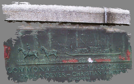
SS clearly wasn't too happy with my 'offerings', but it did struggle along and managed to produce a passable 3-D model, as shown above.
This was not an elegant product, but it certainly was complimentary to the versatility and robustness of the StereoScan application. Though something of a fragment, the model generated does show evidence of a 3-D structure and can be rotated on any of the three axes.
As for the grade I got for submitting this model, it was good, the evaluators were merciful!
FUTURE PUBLICATION -- A QUESTION
by Bill Gerber
The idea of delivering future issues of Towpath Topics "electronically", via email or equivalent, has been proposed any number of times in the last few years. While we do make copies available for "electronic download" (see http://middlesexcanal.org/towpath/), thus far I've resisted abandoning our mailed-out paper version - because: TT is our "flagship publication"; it's traditional, we've published it in its current form for 50 years; and I think that many members aren't all that "into" reading their magazines on-line. But is my understanding of the situation the correct understanding?
Advantages of going to an all-electronic publication are: it would save the MCA some mailing cost, and save those of us who produce it some personal time (mostly Rob, who gets it printed and mailed). Also, whatever color graphics we have can be delivered to you in that form (though much of the available historical graphics are only available in B&W). The electronic form can be fully formatted, as the printed version is, and it can include a page-flip feature; in fact, you'll find three versions of our most recent issues, which incorporate such formatting and features, at the URL cited above. Please do check them out.
One disadvantage, it's not clear to me that one electronically published format would work with all e-readers (iPhone, iPod, iPad, Kindle, Nook, etc.). It would be helpful to hear from you if any of the currently available versions do not work well with your reader.
Please send me an email <BG2013@middlesexcanal.org>, or call (978-251-4971) and leave a message, or send a postcard or letter (16 Princess Avenue, N. Chelmsford, MA 01863) to let me know what you think about the idea of going "all electronic" with the publication of future issues of Towpath Topics.
If you are in favor of it, please let me know what formats your e-reader can accommodate.
A REMINDER
Fifty years of back issues of Towpath Topics, together with an index to the content of all issues, are available on-line at middlesexcanal.org/towpath/. These are excellent source materials for anyone who wishes to learn more about the canal. You can search the archive via Google by including "site:middlesexcanal.org/towpath" in the search bar.
CANAL BOAT RIDES
Compiled by Linda Barth for the American Canal Society, a compendium of known canal boat rides, available throughout the US and Canada, can be found at www.americancanals.org/Canal_Boats/Canal_Boats.htm.
NATIONAL CANAL MUSEUM & HERITAGE CORRIDOR TO MERGE
forwarded by Dave Barber, President, American Canal Society
The National Canal Museum and the Delaware & Lehigh National Heritage Corridor plan to merge, combining the assets of the federally mandated heritage corridor with the story-telling prowess of the museum.
The announcement came at a dinner, [April 18] at the Hotel Bethlehem. "It's a big deal," said Tom Stoneback, executive director of the National Canal Museum. He said the merger adds the reach and scale of the heritage corridor – which manages a 165-mile trail – with the focused Industrial Revolution collection of the National Canal Museum.
"It's simple and small," Stoneback said of the merger. "But simple is often powerful." Stoneback will continue to run the museum. He said the merger comes after 18 months of soul searching and deep talks at the museum after it moved from Two Rivers Landing in downtown Easton to the Emrick Technology Center in Hugh Moore Park, severing the long relationship with Crayola that helped keep the museum afloat financially.
Stoneback believes the merger blends the best of both organizations. The heritage corridor preserves the trails and canals along the route from the coal mines at the source of the Lehigh Canal to the port of Philadelphia – mine to market – while the museum showcases the industrial heritage of the Lehigh Valley that gave rise to Bethlehem Steel.
Elissa Garofalo, president of the heritage corridor, said in a news release that the merger aligns the missions of both organizations to better tell the story of the region's industrial history. The corridor has built 135 miles of the 165-mile trail that reaches from Wilkes-Barre in Luzerne County to Bristol in Bucks County.
The museum's move from Two Rivers Landing to Hugh Moore Park dropped the museum directly into the heritage corridor's turf, further solidifying the two. The combination was first tried at the museum's annual Immersion Days when the heritage corridor's "Tales of the Towpath" curriculum was presented to hundreds of schoolchildren.
The park is the former site of the Glendon Iron Works, one of the first industrial parks in America, and one of the first steel manufacturing plants in the Lehigh Valley. "Our story is coal and coke, and steel and cement, and textiles," Stoneback said, noting that the canal's history is much deeper and important than a ribbon of water for transporting coal to Philadelphia.
The next two years will also bring a major restoration project to the park, funded by $475,000 from the Pennsylvania Department of Conservation and Natural Resources and the Hugh Moore Trust. The Department of Conservation and Natural Resources awarded the park $175,000, with the balance of the money coming from the trust, set up by the Dixie Cup founder to maintain his eponymous park.
The park is owned and run by the City of Easton. Mayor Sal Panto Jr. announced last year that the city would begin efforts to better maintain the park, clear brush and clean trails and picnic areas. The city absorbed park workers and invested capital to repair the old Glendon Bridge and begin restoration efforts.
The museum's collection will remain intact and warm-weather visitors can still expect to see the mules – Hank and George – towing the Packet Boat Josiah White II up and down the canal.
MIDDLESEX CANAL STOCK CERTIFICATES
On August 15, 2013, MCA Board member Betty Bigwood sent out a message to other BoD members announcing a forthcoming auction. Her e-mail, entitled "Canal documents for sale", read:
In todays Wilmington Town Crier, auctioneers James Julia( they rent the 1790-house in Woburn) is offering two documents for sale on August 21st in Fairfield, Maine. One is a Middlesex Canal stock certificate #270 signed by John Adams on 12/1/1798. The other has to do with the transfer of stock to son John Quincy Adams. The sellers live in Woburn.
J. J. Breen managed to obtain images of the documents -
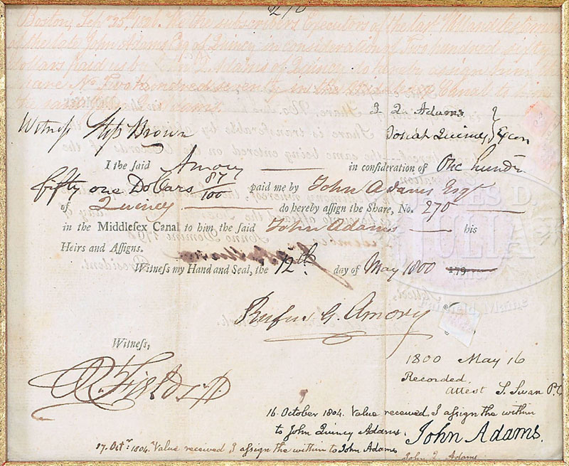
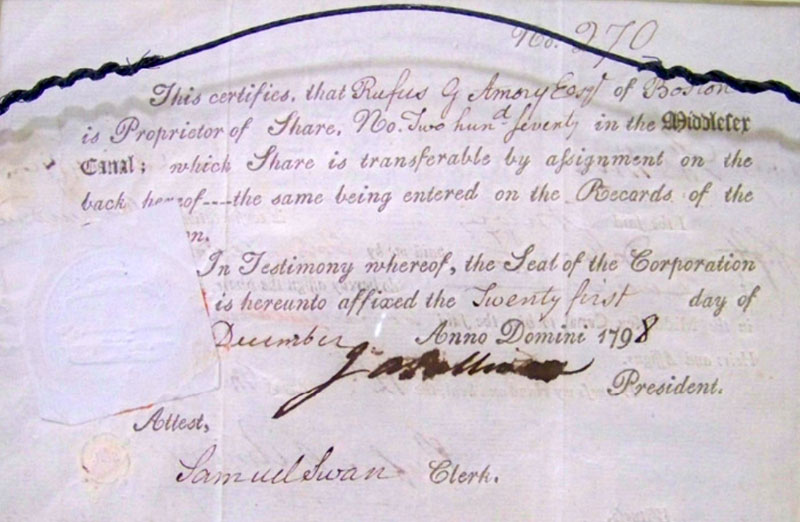
Most recently, in another e-mail, Betty reported:
On August 21, 2013 at the James D. Julia Auction in Fairfield, Maine, two documents were sold - one was a Middlesex Canal stock certificate number 270 that was signed by our second President, John Adams - on 12-1-1798. The second document was signed by John Quincy Adams giving his attorney the power to handle the canal stock after his father's death. The estimate for the two documents was 5-7 thousand dollars. They were both sold for $22,000.
No, we don't know who bought them. And that's the story as we know it!
MISCELLANY
Estate Planning - To those of you who are making your final arrangements, please remember the Middlesex Canal Association. Your help is vital to our future. Thank you for considering us.
Museum & Reardon Room Rental - The facility is available at very reasonable rates for private affairs, and for non-profit organizations' meetings. The conference room holds up to 60 people and includes access to a kitchen and rest rooms. For details and additional information please contact the museum at 978-670-2740.
Web Site - As you may have noted in the nameplate, www.middlesexcanal.org is the URL for the Middlesex Canal Association's web site. Our webmaster, Robert Winters, keeps the site up to date, thus events and sometimes articles and other information will sometimes appear there before we can get it to you through Towpath Topics. Please do check the site from time to time for new entries. Also, the site now contains a valuable repository of historical information, all of the back issues of TT, and an index to all of the articles contained therein, can now be found there at http://middlesexcanal.org/towpath/.
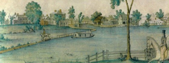
Nameplate - Excerpt from a watercolor painted by Jabez Ward Barton, ca. 1825, entitled "View from William Rogers House". Shown, looking west, may be the packet boat George Washington being towed across the Concord River from the Floating Towpath at North Billerica.
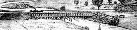
Back Page - Excerpt from an August, 1818, drawing (artist unknown) of the Steam Towboat Merrimack crossing the original (pre-1829) Medford Aqueduct.
Towpath Topics is edited and published by Bill Gerber and Robert Winters.
Corrections, contributions, and ideas for future issues are always welcome.