
Middlesex Canal Association P.O. Box 333 Billerica, Massachusetts 01821
www.middlesexcanal.org
| Volume 49 No. 3 | April 2011 |
MCA ACTIVITIES
Please mark your calendars. The Annual Meeting will be held at the museum on Sunday, May 1st, beginning at 2:30 PM. At this meeting, there will be an election of officers for the forthcoming year. Also at that meeting, Chuck Parrott, from the National Park Staff at Lowell will discuss his research into the Tidal Mills that operated at Mill Creek in early Boston.
The MCA-AMC Spring Walk will take place on Sunday, April 17th, in Woburn. Currently, efforts are underway to open a Middlesex Canal exhibit at the West End Museum, in Boston, for about six weeks through June and early July. See the Calendar, beginning on page 4, following, for more information on our activities. Also included in the calendar are meetings and tours, sponsored by other organizations, in which you may want to participate. Please also check our web site periodically, at the URL noted above, which often lists canal-related events and topics of potential interest.
PRESIDENT'S MESSAGE
by Bill Gerber, President
978-251-4971; wegerber@gmail.com
Among the articles in this issue of Towpath Topics, you will find another transcribed extract from James Fowle Baldwin's unpublished, 1830 'Minutes of the History of the Middlesex Canal' - in this case the report by his father (Colonel Loammi Baldwin) of the elder's 1794 trip to view southern canals (in Pennsylvania and Virginia) and to meet with Robert Morris, General Henry Knox and William Weston. Other articles describe the opening of the Concord River to commercial boating; and the recent finding of an additional 'improved rapid' in the Merrimack River, one that had avoided discovery until this past summer.
A quick update on Nolan; his wife Joan reports: "We are doing well. Now that Nolan's daughter and son-in-law have been trained to help him transfer from wheelchair to walker to car (and reverse), we go out each weekend for lunch or other outing. Very good for our souls!"
At our Winter Meeting, the Board of Directors voted unanimously to accept Russ Silva as a member of the BoD. Note, however, there still are openings for a few additional members or proprietors who would like to participate in managing our association and influencing its direction and activities. Can we add you to our numbers?
A few people have expressed an interest in receiving future issues of Towpath Topics in 'electronic form'. How extensive is that interest? Rob Winters, our webmaster, has created three versions of the January 2011 issue, all with illustrations in color: - in the same form used for all the issues thus far placed on line at http://middlesexcanal.org/towpath/towpathtopicsJan2011.htm; in PDF at http://middlesexcanal.org/towpath/TowpathTopics-Jan2011color.pdf; and as a Flash document (click at the lower outer corner of a page to flip, page by page, forward or backward through the issue) at http://middlesexcanal.org/towpath/TowpathTopics-Jan2011color.html. Please look these over and let us know your reaction to them, and to them as compared to the traditional paper copy, to wegerber@gmail.com. Do we need to change the way we provide TT? How much and what kind of change do we need to make?
In recent time, Roger Hagopian has produced a DVD of Dave Dettinger's talk about the Canal that Bisected Boston. This video was premiered at a gathering of Board members and families in the Fall, and most recently Roger gave draft copies to Board members for a final critique. Most likely this video will have a prominent role in the forthcoming West End Museum exhibit, and hopefully it will be available as a sales item soon.
Over the years, several efforts have been undertaken to develop exhibits that recognize "The Canal that Bisected Boston" (http://middlesexcanal.org/towpath/towpathtopicsMar2008.htm, aka the Mill Creek Canal), and the Middlesex Canal, in the North Station area of Boston. Most recently, several MCA BoD members have been working with Duane Lucia, Executive Director of the West End Museum, to define and develop an appropriate canal exhibit for the WEM. No doubt this will depend heavily on the artistic talents of Tom Dahill.
About that effort, Tom Dahill reports: "On invitation from the West End Museum of Boston, the MCA is preparing a temporary exhibit for that museum from June 1 to July 9 of this year. There will be an identification of the Middlesex Canal, its path and functions; and a featuring of the extension of its purpose by the Mill Creek Canal, which bisected Boston; passing through the Bulfinch triangle and the Haymarket, and continuing on to Boston's harbor by the north east end of Quincy Market [see the graphic on page 16]. A program of lectures and activities will accompany the exhibit. Our budget will be from donations. We hope a portion of the exhibit will be used in the future for forums at which the MCA will be represented. Persons from the MCA involved are: Betty Bigwood, J. J. Breen, Russ Silva and Tom Dahill."
The BoD has had several projects underway that have received little notice. Allow me to tell you about them. The locations are roughly indicated by ovals on the map below.
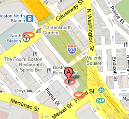 The first of these efforts is intended for the NE-corner of the intersection of Canal and Market Streets. Ongoing for more than a decade, this effort has been conducted by Betty Bigwood, David Dettinger and Tom Dahill, in concert with the City of Boston, to place some sort of exhibit within new construction destined for this location. Changes in ownership and contractual arrangements have caused a redefinition of this effort, but very recently it has again become active and now shows considerable potential for moving forward.
The second effort was initiated by Dave Dettinger, to place a Mill Creek Canal marker on the north-side of the intersection of Causeway and Canal Streets, in the vicinity of North Station. Thus far, Dave's efforts have been met by little interest on the part of the property owner.
The third effort, recently initiated by J. J. Breen, in concert with the owner of the Grand Canal Pub at 69 Canal Street, and timed to coincide with the opening of the canal exhibit at the WEM this summer, is marked on the map by an oval and a pin marked "A". This effort has two objectives (1) to recap the history of Canal St and the now filled-in Mill Pond, in a poster to be placed on a window sill by the entry foyer and (2) to create a mural to be added to the Grand Canal end of the building. Tom Dahill, with assistance of Bill Kuttner, will create the mural. Both of these are intended to be temporary.
Would it also make sense to try to get some sort of recognition for the Mill Creek Canal at the harbor end of the North Building at Quincy Market? E.g., much of the granite that went into building QM came down the Merrimack River and the Middlesex Canal, across the Charles River, and through the Mill Creek Canal directly to that construction site.
We still have an urgent need for volunteers to help staff the museum for one or more of the periods that the museum is open each weekend. Can you help? If so, please contact Betty Bigwood (978-657-7870; <gbchwilm at comcast dot com>). She will initially match you up with another volunteer with good knowledge of the canal and its role in the growth and development of Boston and the towns along its route.
An equally serious need is to raise money to pay the rent to sustain our museum. All suggestions and assistance will be gratefully accepted.
And that's about it for this issue.
Bill Gerber
TABLE OF CONTENTS
MCA Activities
President's Message (Bill Gerber)
Calendar of Events
The Concord River (Bill Gerber)
Updates (Bill Gerber)
Chuck's Channel (Bill Gerber & Chuck Mower)
L. Baldwin's Report … Middlesex Proprietors (transcription)
Miscellany
CALENDAR OF EVENTS
Middlesex Canal Association (MCA) and related organizations
First Wednesday - MCA Board of Directors' Meetings - The Board meets at the Museum, from 3:30pm to 5:30pm, the first Wednesday of each month, except July and August. Members are always welcome to attend.
Apr 1-3, 2011 – "Conquering the Swamp" - The canal societies of Indiana and Ohio will sponsor this tour that covers the Miami & Erie Canal; the Wabash & Erie at Junction, Ohio; and Paulding County, Ohio. Learn the trials and tribulations of digging through a big swamp. www.indcanal.org; <indcanal at aol dot com>. HQ: Holiday Inn, Van Wert, Ohio.
The Annual Meeting of the American Canal Society will be held in concert with this CSO/CSI meeting; on Apr. 2nd at 8:30 PM.
April 15-17, 2011 – Virginia Canals & Navigations Society annual meeting in Buchanan, the western terminus of the James River & Kanawha Canal, with a catered canoe/kayak voyage on the canal's Unfinished Division. Details: Phil de Vos, <phipfox at yahoo dot com>.
Sun, Apr 17, 2011 – Middlesex Canal Association Spring Walk, Woburn. Level 3-mi. joint w/Appalachian Mountain Club. along 2 sections of historic canal, 1:30pm. From Rte. 95/128 exit 35 in Woburn, take Rte. 38 S 0.1 mi., R onto Middlesex Canal Dr. past Ramada Inn to SE corner of parking lot behind Woburn Cinemas. Info: www.middlesexcanal.org. Ls Roger Hagopian (781-861-7868) and Robert Winters (robert@middlesexcanal.org).
April 28, 2011 – Lock 16 Dinner & Lecture: Morton Salt and Other Companies in Relation to the I&M Canal; Jim Ballowe. Lock 16 Center, 754 First St., LaSalle, Illinois; $27 members, $30 non-members. 815-223-1851; www.lasallecanalboat.org.
April 29-May 1, 2011 – Pennsylvania Canal Society tour of the Lower Division of the Lehigh Navigation. Contact: Bill Lampert, <indnbll at yahoo dot com>.
May 1, 2011 – MCA Annual Meeting -- in the museum, at 2:30 PM. We will elect new officers at that time. The speaker will be Charles Parrott from the National Park Service in Lowell. His topic - The South Mill at Boston's Mill Pond and the Reconstruction of its Waterpower System.
One of America's earliest tide mills was built on the Shawmut Peninsula not many years after Boston was settled in 1630. It was located on the south side of a newly dammed cove, known since then simply as the Mill Pond. Millers ground rye flour and corn meal at the South Mill for the town's inhabitants for more than 150 years until the early years of the 19th century when it was demolished and the Mill Pond filled to make new land for the growing city. However some parts of the wooden gearing system that powered the mill's water wheel were deposited in the water course and were subsequently buried until the 1990s when some fragments of them were archeologically recovered in the work of the Big Dig. From those few salvaged pieces, and an understanding of the millwright technology of the period, a conjectural design of the waterpower system that drove the mill was developed. This presentation will recount the story of that reconstruction and show the three-dimensional solid CAD model drawn to illustrate what may have been the design of the mill's ancient mechanical works.
Directions to the Museum/Visitors Center: Telephone: 978-670-2740.
By Car:
From Rt. 128/95, take Route 3 toward Nashua, to Exit 28 "Treble Cove Road, North Billerica, Carlisle". At the end of the ramp, turn left onto Treble Cove Road toward North Billerica. At about ¾ mile, bear left at a fork. After another ¾ mile, at a traffic light, cross straight over Route 3A. Go about ¼ mile to a 3-way fork; take the middle road, Talbot Street, which will put St. Andrew's Church on your left. Go about ¼ mile and bear right onto Old Elm Street. Go about ¼ mile to the falls, where Old Elm becomes Faulkner Street; the Museum is on your left and you can park across the street on your right, just beyond the falls.
From I-495, take exit 37, N. Billerica, south to the road's end at a "T" intersection, turn right, then bear right at the Y, go 700' and turn left into the parking lot. The Museum is across the street.
By Train: The Lowell Commuter Line runs between Boston's North Station and Lowell's Gallagher Terminal. Get off at the North Billerica station, which is one stop south of Lowell. From the station side of the tracks, the Museum is a 3-minute walk down Station and Faulkner Streets on the right side.
May 20-22, 2011 – The Canal Society of New York State Spring Field Trip: Champlain Canal and the PCB cleanup project at Fort Edward. Headquarters: Queensbury Hotel, Glens Falls, NY. For updates, www.newyorkcanals.org.
June 1 to July 9, 2011 – An exhibit that recognizes "The Canal that Bisected Boston" (aka the Mill Creek Canal, http://middlesexcanal.org/towpath/towpathtopicsMar2008.htm), and the Middlesex Canal, at the 7 West End Museum, in Boston. Details can be found at http://middlesexcanal.org/.
Sat, June 11, 2011 – Historic Mill Village Field Trip and Bike Ride. We will gather at North Station and take the 10:00am train to N. Billerica ($6.25 one-way). Those who bring bicycles will visit the museum briefly, and then ride to Boston following the route of the Middlesex Canal. Non-cyclists will enjoy the museum and mill village and return on either the 1:07pm or 3:07pm train. Light refreshments will be served and a $5 donation to the museum is requested. Contact: Bill Kuttner 617-973-7132.
June 18-25, 2011 – The Virginia Canals & Navigations Society's Annual James River Batteau Festival. A fleet of replica whitewater freighters navigates the James for a week, from Lynchburg to (almost) Richmond. Camping is available at all the stops. Details will be on www.batteau.org.
Sept 19-24, 2011 – World Canals Conference in the Netherlands: provinces of Gronigen, Friesland, Drenthe, and Overijssel. More information at www.worldcanalsconference.org.
Fall 2011 – Canal Society of New York State Fall Field Trip, Western Wayne County, For updates, please check the web at www.newyorkcanals.org.
October, 2011 – October 1, 8, 15, 22, 29. The 24th annual guided walking tour of all 58.89 miles of the Delaware Canal from Easton to Bristol, Pennsylvania. 12-mile+/- sections. Visit www.fodc.org for full itinerary.
October 14-16, 2011 – Pennsylvania Canal Society tour of the Juniata Division of the Main Line Canal. Contact: Bill Lampert, <indnbll at yahoo dot com>.
June, 2012 – The Canadian Canal Society and the American Canal Society's Historic Canals Conference, Hamilton, Ontario. to examine the Desjardins Canal (which will be celebrating its 175th anniversary), the Burlington Ship Canal, and Hamilton Harbour and its environs.
September, 2012 – World Canals Conference, Yangzhou, China. www.worldcanalsconference.org.
Fall 2012 – New York State Canal Conference. For updates, please check www.newyorkcanals.org.
September, 2013 – World Canals Conference in Toulouse, France.
THE CONCORD RIVER
by Bill Gerber
Annually, on a weekend in June, the 'Sudbury, Assabet, and Concord Wild and Scenic River Stewardship Council' organizes a celebration of the rivers, called River Fest; in which many adjacent communities and organizations participate. Included in the activities offered, a Bedford resident donates the use of her time, treasure and pontoon boat to conduct trips on the river. In 2009, when I signed up for one of her trips, she suggested that I meet her boat at a given time at "Bedford Landing" (i.e., between Bedford and Carlisle, at the north-east corner where the current Route 225 crosses the Concord River). The name of the meeting site 'raised a flag'; how long had it been known as Bedford Landing?
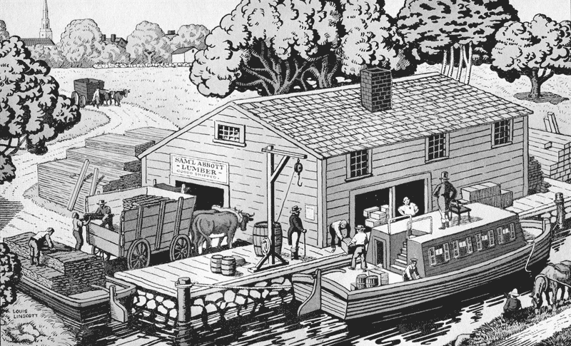
Abbott Landing, Woburn
Louis Linscott Painting
A century and a half ago, when the Middlesex Canal provided the principal means for conveying heavy loads hither and yon, points where the public could ship and receive goods, and where goods could sometimes be held awaiting transport or pickup, were referred to as Landings. Typically, Landings consisted of a dock, some sort of warehouse, equipment to load and unload boats, and a person to manage the transactions. Some such sites were owned by the canal company (MCC), some were jointly owned with the respective communities, and some were privately owned. Could this site have been known as "Bedford Landing" since the days of the canal? Was a cargo exchange facility ever constructed at this site? Were such facilities ever constructed at any of the other points where roads crossed one or another of the rivers? (Regrettably, historical documentation found thus far only 'dances around' these questions; but never quite answers them! The only known Landing near the Concord River was "#7", owned by the Middlesex Canal Company and located on the west side of the river crossing in North Billerica. It may have looked somewhat like the artist's conception above.)
If there were Landings along the Concord River, where might they have been located? Logically, to provide good public access, they probably would have been placed at or near existing roads, bridges and/or fords. Likely sites include those where contemporary Routes 3A, 4 and 225 cross the Concord, ditto the Middlesex Turnpike, and Lowell Road (Rte. 126 extended). Other sites are possible but these look particularly attractive; though, thus far, no indications have been found that facilities were ever built at any of them.
The act of incorporation of 1793 fixed the southern terminal of the canal at Medford River. Having discovered that the Concord River was the summit of the canal, it was believed that the Concord could be made navigable for canal boats. Another act was accordingly passed on February 28, 1795 which included the statement – "That the said Proprietors of the Middlesex Canal shall be empowered to render the waters of Concord River boatable, as far as Sudbury causeway, and as much farther as the same can be usefully improved for that end, and to open any Canal, at any place in the said county of Middlesex, that may be necessary to connect the said Concord River with the said Middlesex Canal, for that purpose, … . And that for the use of any such new Canal or boatable waters, the said Proprietors may receive the same rate of toll which is by the same Act established, for the said Middlesex Canal."[1]
Apparently the opening of the Concord River was not at the top of the Proprietors' list of priorities. In March 2, 1803, the legislature passed another act, which included the following:[2] "--- The said Corporation shall be further allowed the term of six years, from the twenty-second day of June next, to render Concord River boatable and navigable, and for cutting other Canals in the county of Middlesex, pursuant and according to the tenor of the Acts heretofore passed on that subject."
Finally, in his 1808 and 1809 reports to the Proprietors of the Middlesex Canal, John Langdon Sullivan ("Agent" for the canal company) reported expenditures to open the Concord River to navigation as far up as "old Concord". These read as follows, units are in dollars:
| 1808[3] - | Clearing the falls of Concord river, so as to connect it with the Canal, | 86.14 |
| 1809[4] - | Work done on the falls of Concord river to make them more practicable, | 15.02 |
In the back of his book entitled "The Concord River"[5] Laurence E. Richardson provided a table in which he listed the distances, in miles, from the North Billerica Dam to various points on the Concord River. The table is replicated below:
| from Billerica Dam | from Egg Rock, Concord | |
| Fordway Bar | 0.23 | 11.16 |
| Turnpike Bridge | 3.09 | 8.30 |
| Carlisle Bridge [Rte. 225?] | 6.55 | 4.84 |
| Barretts Bar | 10.07 | 1.32 |
| North Bridge | 10.69 | |
| Red Bridge | 11.24 | |
| Assabet Bar | 11.39 | 0.00 |
| Elm St. Bridge | 12.23 | 0.84 |
| South Bridge | 12.34 | |
| Heaths Bridge | 13.86 | 2.47 |
| Fairhaven Bay | 15.53 | 4.14 |
| Lee's Bridge | 16.14 | 4.75 |
| Gulf Brook | 17.44 | 6.05 |
| Sherman's Bridge | 18.63 | 7.24 |
| Canal Bridge | 21.46 | |
| Bridle Point Bridge | 22.53 | |
| Saddle Rock and Farm Bridge | 22.98 | 11.59 |
| Dam at Saxonville | 29.12 | 17.70 |
| Warner's Pond Brook | 14.20 | 2.81 |
| Damon's Pond | 15.93 | 4.54 |
Note the three "bars", i.e., Fordway, Barretts and Assabet. It seems reasonable to assume that the MCC's 1808 and 1809 expenditures were made primarily to cut channels through each of these obstructions.
In 1818, reviewing his ten years' service as agent of the MCC, Sullivan wrote:[6] "The business of the Canal now becomes regular. …, and Concord river before mentioned as appurtenant to the Canal was opened for ten miles to old Concord, and such toll levied as the business would bear."
In his Middlesex Canal manuscript,[7] Lewis Lawrence makes the statement: "It does not seem that much serious effort was made by the proprietors to make the Concord River navigable for canal boats. Its infrequent use is indicated by H.D. Thoreau who said, "formerly, once in a year or two, one of these boats came up the Concord River and was seen stealing mysteriously through the meadows and past the village."[8] Nevertheless the General Court continued to extend the time for rendering the Concord River "boatable and navigable." An act was passed June 19, 1809, extending the time four years, to June 22, 1813, and on February 26, 1813, it was extended five years more, to June 22, 1818.[9] Then the effort was abandoned."
Lawrence's statement is troublesome. Was the General Court not aware that the river had been opened as far as "old Concord"? Not likely! A more plausible explanation might be that the canal company's effort had not gone far enough to satisfy the Court; that the Court intended for the river to be opened as far as Sudbury, on the Sudbury River, and perhaps farther up the Assabet River as well. (The Sudbury and Assabet rivers merge on the north side of Concord at Egg Rock to form the Concord River.)
And what's the value of Henry David Thoreau's observation? Thoreau was born on July 12, 1817. In the town of Concord he lived more than a mile from the river at its closest point, and more than two miles from where boats would have come to in the town. Also, his town was at the far end of the 10 miles of the Concord River that were made navigable in 1808/09. To what extent would he have been aware of river traffic within the first decade of his life? Eventually he may have been aware of traffic that reached his town, but would he have been aware of traffic that terminated at shorter distances, such as at Billerica, Bedford or Carlisle, or of any traffic that may have gone beyond?
In his book "The Concord River"[10] Laurence Richardson, who meticulously researched the histories of towns along the Concord River, tells a substantially different story of traffic on the river, as follows:
"During the first century and a half of the occupancy of the [Concord River] valley by the English, the river influenced the people, the people did not influence the river much; but the advent of the factory system and its demands for power changed this, and about this time transportation on the river had a short revival. Previous to this time, it does not appear that the river was used much to transport anything, although it is said that those from Concord who settled in Chelmsford floated their goods down the river. This is believable, and probably other trips of this kind were made but there is no record of them."
"However, about the end of the 17th century a considerable increase in the use of the river for transportation took place during the construction of the Middlesex Canal from Charlestown to Chelmsford, crossing the Concord River at North Billerica, and using almost exclusively the water of the Concord River to flood its whole length. The canal was completed to the Merrimack in 1798, and a second gristmill and a second saw mail were erected at the dam in North Billerica. By [the end of] 1803 the work was completed to Charlestown. The charter which had been granted in 1793 and extended in 1795, authorized the company to "render the waters of the Concord River boat-able as far as Sudbury causeway and as much further as the same can be usefully improved for that end and to open any canal, at any place in said county of Middlesex that may be necessary to connect said Concord River with the said Middlesex Canal."
"Before discussing the effect this had on our river, we may mention, in passing, a prior canal between the Merrimack and Concord Rivers [the Pawtucket Canal]. Because shipments of lumber (rafts) had difficulty passing the Pawtucket Falls, "The Proprietors of the Locks and Canals on Merrimack River" was incorporated in 1792, and by 1797 succeeded in building a canal from above the falls, 1-1/2 miles, with four sets of locks to drop the 32 feet into the Concord River near its mouth. The traffic which this was built to carry from New Hampshire to Newburyport was soon diverted to Boston by the Middlesex Canal, but in 1823 this canal began a new function by providing power for the new cotton industry of Lowell."
"In the meantime the transportation on the Concord River from Sudbury to Chelmsford or to Charlestown had begun, although at the beginning no effort was made by the canal company to improve the channel except that the improvement of the dam at North Billerica may have made the water a little deeper." [It was 1808-09 when "improvements" were made to make the Concord River navigable. - bg]
"The records seem to show that one of the principal reasons for the canal company's interest in making the Concord River "boat-able" was to transport iron ore to supply the several ironworks at Chelmsford, but it is amazing to find so little recorded about commercial transportation on the river after the canal was operating [in 1804]. All mention of it is incidental to other matters. The history of the town of Sudbury, listing mineral resources, refers to the excellent bog iron ore which was especially good for making cast iron. Dug from a swamp near Puffers Pond, it was carted to Lee's Bridge and floated down the river to the forge at Chelmsford. [The forge was in North Chelmsford, thus the ore boats would have traveled down the Sudbury or Assabet and Concord Rivers to North Billerica where the floating towpath would have been opened to admit the boat into the canal. From there the boat would have proceeded on the canal to the Merrimack River, and up that river to the forge. - bg] In 1830, 300 tons was thus transported. Shattuck in his History of Concord describing the iron works at West Concord which was finally abandoned says that 'recently several tons were taken to Chelmsford by boat,' and that would have been down the Assabet."
"He also says "boats frequently run from Boston through the Middlesex Canal and this River to this town in Sudbury". Someone of the past generation has told that the bricks for the Hildreth house on Lowell Road in Concord were brought up the Merrimack and Concord by boat from Haverhill, and the bank of the Assabet where they were unloaded can still be identified by the broken pieces scattered about. The certainty of this is substantiated by chemical tests made for a former owner of the house who wanted to determine the source of the bricks."
"There is also testimony before a legislative committee in 1860 which was investigating one of the many complaints of the farmers about the water on their meadows. John Sherman of Lincoln said, 'I had a canal boat and used to clear wood from near my meadow, and boat it to the canal to Boston in 1816-17". When we returned men had to draw the boat up. Couldn't get up the river with a load in dry weather. My boat drew something over 2 feet.'"
"Stedman Buttrick, who lived where he could watch the river from his window said; 'I helped clean out the bar for boats, full loaded with wood, could go down to the canal at Billerica.' Hemen Ray of Lincoln said: 'I boated on the Concord River in 1816-17. We rowed from Bent's Landing down as far as Concord.' Nathan Barrett who could watch from his house on Punkatasset Hill said; 'there used to be a boat running, regularly, from here to Boston up to 1840. The bar was cleared out in 1835 to go through without grounding.'"
"Other evidence appears in the canal records which shows that '15 tons of coal may be sufficient load for those (boats) going up to Concord or Sudbury.' And at a Lowell Historical Society meeting in 1874, John D. French of Billerica recollects 'that on the Concord River there was a large business in summer by boats from Concord and other points on the river, transporting wood, goods, and lumber, and in floating rafts.' Continuing he explained that ox cart was the only other way to move heavy goods in 1813-14. People rode horseback, and maybe the very fashionable had a chaise, but wagons had not appeared and the roads were not good enough for them."
"Dr. E. W. Emerson in writing of Ebenezer Rockwood Hoar, tells of a political speech he made '... on the occasion of the great political gathering of Whigs at Concord, in 1840, the campaign of Harrison and Tyler, when not only were the roads filled, but great numbers came on canal boats poled up the Merrimack, and even from the Mystic by the Middlesex Canal. A bridge of these boats was made at the battleground . . . .'"
"But it was not long before land transportation improved, and the railroads replaced the canal. Transportation on the canal ceased in the 1840s. Before its final death as a corporation, it [the Middlesex Canal Company] tried to sell its property to the city of Boston which at that time had no water supply but wells and cisterns. Four eminent chemists testified to the quality of the Concord River water, and it could float right down the canal from Billerica to the edge of the city."
"Short though the life of the canal was, its authority to dam and use the Concord River water caused controversy for many years. The first dam at Billerica in 1807 was promoted by the town to provide a grist mill. This was a leaky, unstable zig-zag barrier built across a chain of rocks which held up the water enough to increase the power available and channel the current to the sluice way for the mill wheel. The canal company purchased this but it was not enough to keep the canal full for it's 22 miles to the Charles and 6 miles to the Merrimack, so the dam was raised and strengthened and this theoretically should do the job, for it made the mill pond 27 feet higher than the Merrimack above the falls and 107 feet above tidewater at Boston."
"It was not long, however, before it was discovered that sometimes the Concord had almost no current. (Only about 1 inch drop per mile for 22 miles) and to get enough water to operate in a dry summer the canal company took steps to clear out the channel by digging out the bars and mowing the weeds; and the farmers who had done this before cooperated as they wanted the water off their meadows in summer. The critical spots were a ledge of rock at the Fordway in Billerica about which nothing could be done, and Barrett's Bar near Punkatasset Hill in Concord, the Assabet Bar just below Egg Rock, Robbins Bar below Pantry Brook, and a few others all the way to Wayland which could be dug out and cleared of weeds."
"Mowing weeds might be a yearly job and although machines were devised to be pulled by oxen, (one man told of seeing 10 to 12 yoke working back and forth, almost completely submerged), it was often necessary for men to work with scythes, up to their necks in water. A new stone dam was built at Billerica in 1828 which helped some, but after the canal stopped operations and sold out to mill interests the demand for water was even greater."
_____________
Biographical Sketch of Laurence E. Richardson[11]
Commercial Boating on the Concord River below the North Billerica Falls, after 1837
Prior to 1837, freight destined for Lowell had to be unloaded at Middlesex Village and carted overland the rest of the way. In order to provide an all water route for canal boats, the directors voted, July 23, 1830, that the "agent have a survey made from Billerica Mills to Hamilton Canal at Lowell or other points and estimate cost of a waterway by locks and canals or by Concord River." Three routes were surveyed by Caleb Eddy and George R. Baldwin. Finally, in the summer of 1837, a new lock was completed, connecting the canal with the Concord River below the dam at Billerica Mills. This lock had been a favorite project of one of the stockholders.[12]
Built a little beyond the western raft lock in North Billerica, Red Lock, as it became known, enabled boats to travel directly between the Middlesex Canal and Lowell (in Lowell, probably as far as the southern end of Centennial Island). This eliminated the overland haul to that place from Middlesex Village. The ruined stone work of this lock still remains. Above the dam, the river remained open "for ten miles to old Concord, and such toll levied as the business would bear."[13] [14]
Notes:
1. Private and Special Statutes of the Commonwealth of Massachusetts. 14 vols. (Boston, 1805 - 1882).
2. Idem
3. Sullivan, John L. Agent of the Corporation; Statement of Expenditures and Receipts on the Middlesex Canal, in the Year 1808.
4. Sullivan, John L. Agent of the Corporation; Report to the Proprietors of the Middlesex Canal, at their Meeting on the 3d February, 1810.
5. Richardson, Laurence Eaton; The Concord River; p-74; Barre Publishers, 1964
6. Sullivan, John L;. Letters First Published in the Boston Daily Advertiser. (Boston, 1818)
7. Lawrence, Lewis M.; The Middlesex Canal, Boston Mass., 1942, manuscript, p 53; published by the Middlesex Canal Association
8. Thoreau, Henry David;. A Week on the Concord and Merrimack Rivers. Boston, 1893; first published 1849
9. Private and Special Statutes of the Commonwealth of Massachusetts. 14 vols. (Boston, 1805 - 1882).
10. Richardson, Laurence Eaton; The Concord River; pp 33-38; Barre Publishers, 1964
11. Concord Free Public Library, Concord, Mass. Richardson Family Collection, [ca. 1855] - 1985 Vault A45, Richardson, Unit 1 (c2006). Laurence Eaton Richardson was born in Concord, Massachusetts on 10 December 1883, the son of Henry Preston and Maria (Smith) Richardson. He attended Concord Public Schools and graduated from Harvard College in 1916. Mr. Richardson served as a U.S. Army Captain with the military police during World War I and in France during World War II as a Second Lieutenant with the 101st Field Artillery. A lifelong Concord resident, he was active in town government and community organizations. He wrote several volumes on Concord history, including Concord River (1964) and The Concord Independent Battery (1973). Laurence Richardson was married to Anne (Weed) Richardson and together they had three daughters. Both Laurence and Anne Richardson died in 1985.
12. Middlesex Canal Records. Original records of the proprietors. Center for Lowell History, Patrick Mogan Center, Lowell MA.
13. Ibid
14. Sullivan, John L.; Letters First Published in the Boston Daily Advertiser. (Boston, 1818).
UPDATES
by Bill Gerber
Dave Dettinger's excellent article entitled "The Canal that Bisected Boston" (aka Mill Creek Canal) was published in the March 2008 issue of Towpath Topics; see http://middlesexcanal.org/towpath. Since then a graphic has turned up that does a better job of portraying the expansion of the Boston waterfront, the location of Faneuil Hall and the the Faneuil Hall Marketplace (aka Quincy Market) buildings, and the relocation of the Mill Creek Canal to accommodate the harbor end of the north-east building (upper building in the graphic below).
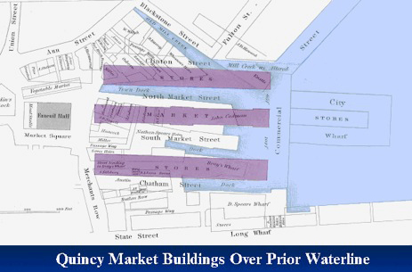
From Mapping Boston, edited by by Krieger and Cobb, MIT Press, p-149.
A second update: in my article about Sullivan's Steam Towboats I noted that both of the boats that Sullivan built in 1812 used chain-floats drives patented by Michael Morrison. While this is not in question, it appears that Morrison was not the first inventor to come up with this idea for driving boats. In her superb book "Steam", Andrea Sutcliffe tells of the struggle between John Fitch and James Rumsey to develop a practical steam boat. (No,contrary to popular history, Robert Fulton did not invent the steam boat!). Included among Fitch's related inventions was an "endless chain of paddles, as depicted in the diagram below.
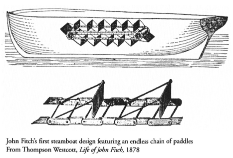
From Steam, by Andrea Sutcliffe, Palgrave MacMillan, p-144 f.
Different words, but the same idea as a "chain-floats drive"; and from Sutcliffe's book, a diagram to help the reader visualize what the drive must have looked like. That Sullivan chose to place the chain-floats drive in a trunk in the center of his first boat, as it appears that Fitch did, makes one wonder, did Sullivan know of Fitch's work? Did Morrison patent what Fitch invented?
CHUCK'S CHANNEL
by Bill Gerber, initiated by Chuck Mower
Soon after my interest in historical canals began I became aware of the Middlesex Canal, and fairly quickly the Canals of the Merrimack River too. Along the way I picked up two mentors, Fred Lawson for all things Middlesex, and Chuck Mower for all things Merrimack. Recently, Chuck posed the question, "if he found a new canal, would he get to name it?" It appears that he has found one, but he has yet to suggest a name. Until he does, or history suggests one, I'll refer to it as "Chuck's Channel"!
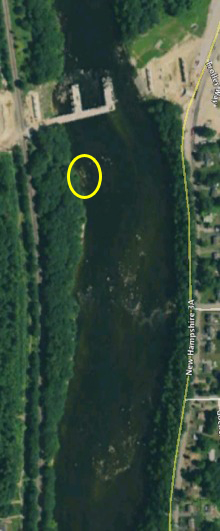 |
| Fig. 1. Google Earth View Site of an 'Improved Rapid' and Landing (near the new Merrimack River Bridge) |
"The new canal [from Google Earth; within the shoal areas below the bridge construction site, which appears near the top of figure 1, right] seems to coincide, within two or three hundred feet, with the border between [the NH towns of] Merrimack and Bedford. Just downstream from this obstacle is a second Bar which extends only halfway across the river. There appears to be an improvement in the river channel that extends north and south along the midstream boundary between Merrimack and Manchester."
"If you look on Google Earth, be sure to use the time function to get the best views of low water and sunlight. Its been staring at us all this time."
Chuck provided three close up photographs of this area of interest. The first, figure 2, looks up river toward the channel, on the left, with the new Merrimack River Bridge (which will provide access from the Everett Turnpike to the southern edge of the Manchester-Boston Airport) in the background.
"On the Merrimack side all the rocks have been cleared away for a thousand feet or so. [Almost certainly, this is] the work of the Union Lock and Canal Company, superintended by Issac Riddle and Caleb Stark." This 'improved rapid' allows passage through a bar in the river when the water is low. You can see the new bridge crossing a short distance upstream. Just below the new bridge is the mouth of Darrah brook which powered a gristmill, sawmill and turning mill in Bedford."
"I had never been down through here when the water was this low and so had missed this all these years. There is evidence of a large landing on the opposite side of the river and just upstream of the new bridge. Tantalizing archeology."
"I [recall] our flight over this area several years ago. It was busy around the airport and we were lucky to get what we did. [While up there] I saw this straight line in the river but could not give it locus after the fact. I believe you were very busy trying to get Cohas falls in your [camera] sights."
"This is a significant engineering improvement that, once again, gives us pause to the depth and the commitment of canaling as an improvement for the ages. I wonder if there was some charted covenant that might have required adherence to the boundary between Towns?"
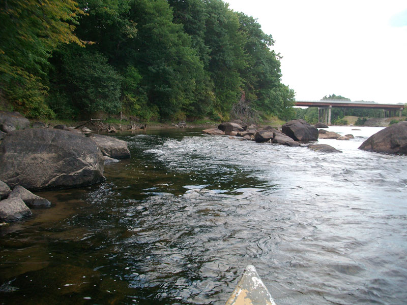
Fig. 2. Improved Rapid, Left Side of River; Merrimack River Bridge in Background
Figures 3 & 4 are of the channel from above and within the channel looking downstream.
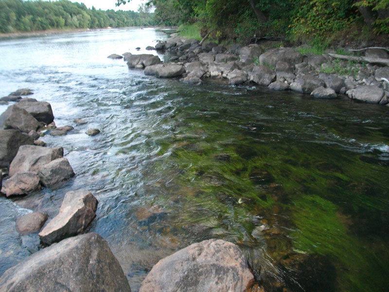
Figure 3. View of the Improved Rapid, looking downstream, from above the channel
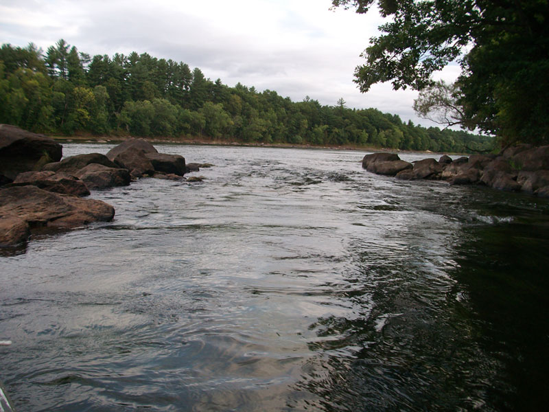
Figure 4. View of the Improved Rapid, looking downstream, from within the channel
Since this channel does not include a lock, what Chuck is describing as a canal seems to be what I've generally described, and seen referred to, as an 'improved falls or rapid'. Various canal companies made improvements to a number of rapids; at least eleven that have already been accounted for along the Merrimack, and now apparently a twelfth. (These now include: Turkey, "Chuck's", Cromwell's, Hill's Crossing, Taylor's, Wicasee, Hunt's, Varnum's, Peter's, Parker's, Bodwell's and Mitchell's Falls. For more information see the January 2009 issue of Towpath Topics available at http://middlesexcanal.org/towpath). And three more along the Concord River (the Fordway, Barretts and Assabet Bars; see the preceding Concord River article), none of which are apparent today. But, though undocumented, what we have here is an improved channel that obviously still exists.
Nowhere, in any documentation that I've found, is the term "improved" falls or rapid explained, i.e., in the context of the labor performed to make it so. Nevertheless, it seems quite reasonable to assume that each of these consisted of a channel made navigable by clearing rocks and boulders along a path, and doing whatever else was needed. In some cases, I believe, the work may also have included construction of a wing dam to divert more water into the channel, though this seems not to be the case here.
Loammi Baldwin's Report to the Middlesex Canal Proprietors
As Recorded by James Fowle Baldwin
transcribed by Bill Gerber
In 1830, James Fowle Baldwin wrote a draft of a history of the Middlesex Canal.[15] Among the many items and events described in this unpublished document is an account of his father's report to the Proprietors resulting from his trip to examine southern canals, and to meet with Robert Morris, General Henry Knox and William Weston.[16]
James Fowle Baldwin's history, along with two books of drawings by George Rumford Baldwin, are owned by the Winterthur Library, Winterthur, Delaware. Permission to transcribe and publish this and future extracts was granted - Courtesy of the Winterthur Library, from the Joseph Downs Collection of Manuscripts and Printed Ephemera, Col. 204.
The article below is the second of several pertaining to Baldwin's trip; related articles will appear in future issues of Towpath Topics.
This transcription from the handwritten document is provided as a 'best effort'. That is, the words are transcribed as accurately as I was able to decipher them. I've expanded selected contractions and enclosed them in [brackets] and I have inserted a modicum of punctuation.
I again extend a hearty thank you to Jean Solensky, of the Winterthur Museum, for her proof reading of and corrections to my transcribed text.
L Baldwin's Report of his Examination to the South, April 22, 1794 [17]
To the President, Directors and Proprietors of the Middlesex Canal. __
The Report of Loammi Baldwin, Agent for the Company appointed to repair to Philadelphia to obtain W'm Weston's assistance, examine Canals in the Southern States &c. &c.
Pursuant to my appointment I set out on the 10 March last [1794] and proceeded to Philadelphia from whence I wrote the President the 26th letter but in great haste (being just setting out for the Potomac) I therefore ask leave to revise the letter & that it may be considered as part of my report being exceedingly interrupted with incessant avocations & press of time. _
In the morning of 24th I set out from Philadelphia & proceeded on through Pennsylvania & Delaware States without meeting with anything essentially interesting to us in the present enterprise, nothing going forward in the Canalling line in the State of Delaware. _ In Maryland I was informed that a canal was making on the side of the Susquehannah under the direction of a Mr Brindley, an English gentleman, but the work was not in any part completed & represented rather in a contemptible light. One gentleman told me that he had seen the waters of the River Eight or ten feet deep over the work. Others spoke more favorably of it, however I did not go to view it being at a considerable distance from where I passed & the stages very much crowded so that if I had once quited my place in the carriage it might be a week or more before I could have recovered another. _ I arrived at Georgetown on the Potomac at evening 26 March last. _ I had letters of introduction from Docr Appleton to several Gentlemen in Georgetown and Washington which had an agreeable effect tho' some of the gentlemen were absent from home. _
Mr Templeman, formerly of Boston, was very attentive & sent for me on my arrival at the Stage house & offered me every assistance in his power. _ Col. Dickinson to whom I had letters from Dr. Appleton was also present & agreed that as Mr Templeman was bound to Baltimore next morning that he would wait on me himself to view the Canal & Locks. _ Next morning I set out for the Canal with Col. Dickinson who is one of the principal directors on the company, attended by Mr Harbook, a German Artist but never before practised in Canalling. He is very ingenious & appears to execute his work in the most perfect manner, except the large Stone Bridge which was built about two years ago over Rock Creek at the City of Washington, which fails a little in the centre arch, which perhaps serves to admonish him for past error - he very readily answered me to every enquiry I put with precision even to measure and manner of connection with the angles & movements.
I was particular in my observations and gotten the most perfect information that my opportunity and the state of the work would admit of. _ The canal at the lower Falls begins about 3 miles above Georgetown on the east side of the Potomac in Maryland and extends about 2 1/2 miles up the river, is cut partly in rock and partly in gravel and a kind of reddish clay just high enough in the side of the bank of the river to be out of the way of Freshes, perhaps not quite high enough for that._
The lower side of the towing path or bank of the Canal next to the main river is handsomely stoned with rough stone laid without any kind of mortar, but the inside of the canal is not stoned on either side, except a few yards on each hand of the Sluice-way made thro' the bank at certain distances on the lower side of the canal to let off the redundant water and to assist in taking the water wholly out of the canal & forcing it from the land floods & rivulets that come down the mountains; these sluices when the Gates are drawn, open a passage of about 2 feet wide and one deep; there is one considerably larger, these sluices are executed with locust wood. – In addition to these sluices, in this, there are frequently openings in places left in the bank or towing path on the lower side of the canal next to the main river say thirty or forty yards in extent where the bank on the side of the canal is no higher than the level of the water as it is to stand for use in the canal. The towing path in other parts of the canal is to be a foot and a half or two feet higher than the water, so that if the water should from any cause rise higher than designed it will escape through those openings in thin sheets proportional to the excess of water, these openings are secured against washing away by a kind of stone pavement which will serve also for the horse to walk upon in the water if slight plank bridges would not be made for that purpose.
 The openings are generally opposite, or in the course of the gulleys or hollows where the water descends down the mountains or great Banks on the side of the river.
There are on culverts or drains under the Canal. The Canal is to be twenty one feet wide at the bottom, three & a half feet deep to the surface level and about twenty six feet wide at that place; The towing path about 8 or 10 feet wide - The Canal is roughly cut the whole extent & they are now going over it with a finishing hand; perhaps one half is already done. _
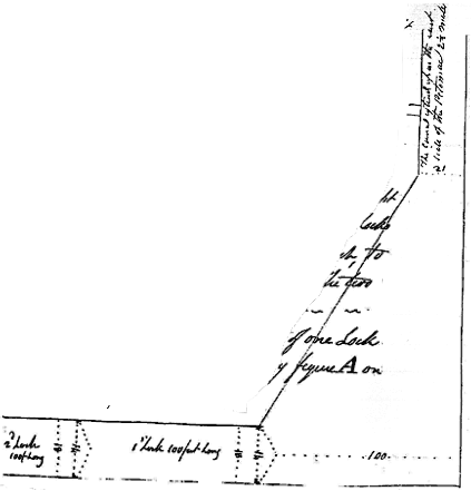
The level of the River above the falls is preserved by the Canal to the foot of the falls where the canal suddenly opens and spreads to 100 foot wide, as represented by the figure on this paper, & turns nearly at right angles & descends thirty seven feet by three locks executed in wood an hundred feet long each, to navigable waters below the falls. The two upper locks were nearly completed.
The timber work at the bottom of one lock before planking is represented by figure A on a separate paper. The timbers that run lengthwise are locked together with the crop pieces of mud sills by gains cut in each, yet not so as to be let down flush, the long pieces lay just the thickness of the plank (3 inches) above the crop pieces the better to preserve their strength so that when planked between them it makes them perfectly smooth and even. _
The side is represented by figure B, every other part is supported by a brace on the bank side represented by the section C and every other port alternately supported by a land tie as represented by the section figure D one pair of Gates (upper) with the dead resting on work underneath them is represented by figure E. _ The water has been let in just to prove the work & it is thought will answer very well. _
From this I proceeded alone about 12 or 15 miles up the river to the upper Canal at the big falls, as they are called. _ This Canal is on the west side of the Potomac in Virginia & is finished for near a mile & an half down from the head of the Falls & there the work ends. At that place are to begin & to be six in number & must be (almost wholly) blown out of solid rock for more than half a mile, but when done will be durable as time itself, and will require little or no timber except for the gate. _
I was informed the River is navigable for 200 miles above this place and may perhaps be ranked in point of magnitude in the same class of Rivers with the Connecticut. _
About 60 miles above the Canal on the west side of the Potomac is the confluence of the Shannandoah, a fine River in Virginia which gives name to a country famous for wheat. _
I was told by the store keeper that there had been landed from this Canal to his care about 12,000 barrels of Flour since last October, besides large quantities of wheat, pig iron and other articles - from thence the principal part is transported in wagons to Alexandria, about 25 miles. _ The roads in this country are generally bad and almost totally neglected in the way of repairs except in the neighborhood of Alexandria where there is a turnpike.
There are scarcely any bridges over large or small waters, all which makes the canal of more importance & when completed will, it is expected, render wagoning unnecessary. _
However, in riding up the river between the lower and upper Canal I purposely kept [to] the bank as far as I could conveniently and crossed at W Cloud Ferry. _ I observed a difficulty there which I fear will operate with similar effect in our project, which is the quickness consequently [of] the power of the current against the returning transports in going up the main River.
There is a Canal begun in the new City of Washington about 2 miles east from Georgetown & is cut about 2 miles but completely [un]finished in any part. I think there will [be] no occasion for any locks in it. _
For a more general history and extensive view of the country with particular observation on the inland navigation I beg leave to refer you to a pamphlet entitled "observations on the River Potomac, the country adjacent & City of Washington" which I take the liberty herewith to present the company it contains some observations direct in point as applying to us.
In the morning of 29 [March] I took passage in the stage and returned to Philadelphia the first of April instant found that neither of the companies had cleared liberty for W. Weston to go to Boston, but the several company, consisting chiefly of the same persons, especially the leading characters with Mr Morris at the head spoke in terms very encouraging and observed that W Weston must also visit the New York Canal and afford that company some assistance wether in going to Boston or returning.
I very cheerfully acquiesced in his assisting them on his return but observed that we could not proceed one step until we could procure an Artist to determine on the precise route of ground where the Canal is to be cut, and that I apprehended that their work was, for the present, delayed from other causes than the want of an Artist. They seemed ready to give into this proposition and all the conversation on this had implied fully that W. Weston would go on to Boston about the middle of June next and assist us about four or five weeks at that time and attend the New York company on his return, & visit us again next Spring.
In private conversation with W Weston I used every argument in my power to persuade him to come on by the first of June so as to be there by the middle of that month, but he replied that he must get the work there in such a state before he could leave it, that he can declare to the board of Directors that their interest will not suffer essentially by his absence, which he thinks will not be in his power to accomplish before the middle of June; however he engaged to write me about the middle of June or latter end of May next & let me know what his prospects might be at that time. _
At a particular time among a number of other questions which I put to him in writing was the following which I desired him to answer in writing viz: At what time will you be at Boston in order to lay out & direct the Middlesex Canal? His answer was as follows: "Application will be made to the President and managers of the Schuylkill & Susquehanna Canal to obtain their permission to survey the Merrimack Canal the middle of June which if granted will enable me to be at Boston at the end of the same month. WW"
I frequently requested a decided answer to my application observing I had rather have a flat denial than anything short of what would amount to a commitment by that time, but I could not get so positive an answer as I could wish, however everything that was said & done on the subject seemed to imply an answer in the affirmative and I have no reason to doubt but that he would be here the latter end of June. I asked him if we could not improve the interim to some advantage" he answered me yes be sure there is enough to do if we had made our preparations already. _
I asked him to give me a memorandum in writing of what may be done to advantage which he very readily agreed to do. He then asked if we had any leveling instruments? I told him I thought there might be Instruments procured from the apparatus at Harvard College that would answer. _ He said we had much better send to London for two sets - as we should have frequent occasion for them through the whole course of the work. I asked him to make me out a memorandum of the kind that was suitable and name of the instrument maker when we might apply to for them, which he did in my presence, but I fear he has not sent it up with the rest of the papers as I don't find it on opening them, however I think I can recollect enough to make out a memorandum if the company [is] inclined to send for them, and as it would be impossible to procure any from London by the time he should want them & it being uncertain whether the right-kind could be procured at the College, he chose to send on his own & asked me if I found an opportunity by water to let him know it, & he would put them on board the vessel as being less liable to injury than by land conveyance. _
I made inquiry the next day & found Capt. Cheesman on the schooner Gen. Heath owned by Capt. Merry & bound to Boston in a few days. I acquainted W Weston with this opportunity, he immediately sent to the upper end of the Schuylkill Canal, about 17 miles, and had them brought down & I put them on board Capt. Cheesman myself in two Boxes with a station staff & target by themselves making three parcels in the whole belonging to the instruments. He also gave me a navigation spade as a sample for us which I also put on board at the same time. He afterward offered me a wheel barrow of a particulate construction for the same purpose, but when we went to the navigation office for it, they had all just been removed out to the works, however he engaged to send for one next morning & put it on board the same vessel & when they come to hand shall present them to the board of Directors for their inspection. _ He also gave me the following memorandum _
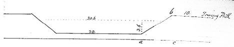
Section of the Middlesex Canal supposing it calculated to receive boats
sixty feet in length and nine feet in width, burthen Twenty Tons.
| Width at Bottom | 20 feet |
| Width at Surface of water | 30-1/2 do |
| Depth of water | 3-1/2 do |
| Width of towing path | 10 do |
| Towing path elevated | 1 do above the surface of the water |
| The internal angle (b a c) is 33 degrees | |
Price of contract work by the cubic yard, viz
| Digging when the earth is not moved more than 25 Yds | 7-1/2 |
| Ditto … when moved more than 25 yards & under 40 | 8-1/2 |
| " more than 40 " & under 60 | 10 |
| " more than 60 " & under 80 | 11 |
| " more than 80 " & under 100 | 1/ |
| " more than 100 " & under 205 | 1/1 |
| " more than 2 " & under 400 | 1/2 |
Bricks ten inches in length, five in width, three in depth. _
An Eight-foot dock capable of receiving a Boat sixty feet in length & nine in width require 200,000 bricks _ A quantity of short piling five feet long & four inches thick to apply in the gravel at the head of locks to prevent the water from passing under the counter arch or bottom of the lock to be matched together thus

I asked him whether it would do to make use of ponds when the water was good & lay in the course, his answer was that he knew of no objection against it. I asked him how they would get the boats along as there would be no towing path, his answer was detach the horse & send him round & set or row the boat along as they do in many places in England.
When I mentioned the passing of rafts in the Canal he seemed to revolt at the idea and decreed a perpetual prohibition of all lumber Rafts with raw edges, ends and angles which will always be gnawing and chafing the sides of the Canal, the gates and brick work so that one raft will do more damage to the canal than 500 boats built upon a proper construction. _ Besides I think Rafts will be much slower in their progress & when made of board or plank some of them must be put crosswise in order to tie the rest together, consequently will make the rafts near 20 feet wide which will almost extend across the Canal so as to prevent a boat that is going the same way from passing by it, although it could move 3 times as fast as the raft & totally prevent a meeting boat from passing by only at certain places which may be made for that purpose, which would be a great inconvenience & obstruction to business. _ _
I showed him our Plan and described the Lands we had surveyed for the course of the Canal as well as I could but he reprobated the idea of following the natural course of the River if it can possibly be avoided. For his observations and reasons against it, and for answers to several other questions which I put he referred me to his report made the 15th of January last to the President, Managers & Company of the Schuylkill and Susquehanna Navigation, which I have subjoined to this report as being applicable in some instances to us and tending to open the view and enlarge the mind upon the General principles of Canaling.
I wished to know of him whether we could not with safety begin and cut from the River at the head of Mistick Pond up to Wedge Pond about half or three quarters of a mile if we found the route by way of the Ponds practicable? he answered me yes, he supposed we might very well.
When I waited upon Mr. Morris, to acquaint him that I intended soon to return to Boston, he informed me that a French Gentleman had made applications to him through Mr. Theopiles Cazenave to be employed & rather advised me to see him and observed that perhaps he might be somehow employed in our work to advantage but was totally unacquainted with his abilities. However I applied to Mr. Cazenave, who gave me his name and showed me some of his Plans & Drawings which appeared well executed.
Afterwards, Mr. Dufereau (for that is his name) called on me at my Lodgings but I found (as I had been informed) that he could not converse in English, however there was an Interpreter at hand, among a number of Questions I put the following in writing viz
Can Mr. Dufereau survey and take levels accurately? __ Yes
Have you any Instruments for that purpose with you? __ No, being driven from his home by the Enemy he had nothing but his clothes.
In what are the Locks to be executed, whether wood, Brick or Stone? __ In either but stone is best, Brick next, wood will do. Wood under water is better than Brick
What compensation shall you expect for your service if employed per month? __ Will leave that entirely with the Proprietors.
Mr Weston is to be Chief & first Planner & Superintendent of all the work? __ Is willing for that
What must the Proprietors give you to go to Boston if when you come there they should not employ you? __ Pay his necessary expenses
I asked him verbally whether he had been actually employed in Canaling? __ Yes, he had.
When have you been thus employed? __ At ________ in France
I went with him to Mr. Weston and acquainted Mr Weston with what had Passed & asked his advice, who replied that he was a total stranger to him, could say nothing about it but had no objections to his being employed. I told Mr Weston that our dependence was placed in him therefore would employ no Person but what should be under his direction and agreeable to him. He replied that he should make no kind of objection but observed at the same time that he presumed the Proprietors of the Middlesex Canal could find some person there adequate to the business, but he should leave that entirely to them to appoint whom they pleased.
I then went with Mr Dufereau to Mr Cazenave who could converse in French; he told me that Mr Dufereau was turned wholly out of business, that he wished to be employed by our company, that he would go into our service until his merit could be proved for only just his subsistence, & then if found useful only just reasonable pay such as we might agree to give him. I proposed to write him as soon as I could get the determination of the proprietors.
Mr Dufereau wished me to go with him to the Schuylkill Canal in order to show me some defects which he thought there was in the work. Accordingly I went, he first observed that the arch of the Culvert on the upper side of top which were only the width of one Brick thick which he thought too weak & tender for to endure well & that it would be almost impossible to replace them afterwards as some of them lay more than forty feet below the water level in the Canal under a vast body of earth & that the loose earth where it lays in such depth will not be firm enough to sustain the water. _ and the Gravel it was cut through the hills would run down the sides and obstruct the passage. However he said it might possibly answer but considered it rather defective in there particular.
I thought he appeared to converse with judgement on the subject. However I left it so that I am to write him if the proprietors shall conclude to have him come on which will be necessary for them to take up and consider as possible and also to determine the same question respecting W Bewell.
There is also a Mr Hall at Trenton, and a Mr Nesbet from England but now residing at New York near Hell Gate on the Sound whose characters have been given me in very flattering terms - However I did not see either of those gentlemen - supposing that as one of them lived in the neighborhood of Philadelphia & the other in New York that the Navigation Companies at those places would naturally have employed them if they had considered as adequate to the business of superintending their Canals - Besides when I went on I expected to procure Mr Weston when I returned I considered that he was engaged therefore the assistance of those persons became unnecessary without the Company shall choose to employ some one or other of them under Mr Weston which will be the business of the company to determine.
My instructions authorized me to publish the advertisement expecting an Artist in New York, Philadelphia and Baltimore papers; also to write to Europe for an Artist if any could be recommended. Also to engage Capt. Hills to come on according to his proposals - all which in a great measure became unnecessary after Mr Weston fared to assist us. He told me that he knew of no person in Europe whom he could recommend as an artist & that Mr Hills service as surveyor would be of no use at all as he should choose by all means to take the survey himself. _
On my return I visited the Canal at South Hadley in this state _ I found it a work of prodigious labour, being cut for a considerable distance in a Rock in some places from 10 to 18 feet deep - The whole extent is about 2-1/2 miles exclusive of the Dam at the head of the Canal which was made at a great expense & over obliquely across the River near 3/4 of a mile, part of which has lately been carried away by the flood, not being sufficiently loaded with stones to counteract the buoyant power of the timber it was built with.
There is a kind of Lock at the head of the Canal with two pair of Gates which seem calculated principally to regulate the water in the Canal in the time of great freshets. - at present there is no water in the Canal although the Gates are open, owing to the breach in the Dam _ The water is to stand on a level in the Canal the whole distance and the transports are to ascend from the Main River at the foot of the falls about [53] feet upon an inclined plane into the Canal. _
I doubt whether this mode will be found so easy & convenient in the operation as to ascend by Locks -
The Canal is narrow, I believe not more than 16 feet wide and about 3 feet deep, but if made to answer the purpose will be of great public utility. _ It is executed under the direction of Mr Benjamin Prescott, a gentleman of great mechanical abilities.
I agreeably to my instructions conversed with Mr. Morris, Gen. Knox & such other Gentlemen as I thought would be useful to us. I have seen and as far as was in my power engaged Mr. Weston. _ I have visited all the Canals to which I could conveniently have access & have gained all the information I could on the subject of Canalling & here report the same (journalwise) to the board in a simple stating of facts without attempting to lead or Control by my opinion lest my (perhaps my) too sanguine hopes should meet disappointment & I should justly merit censure, however I cannot refrain, but must say that I consider the prospect before us in this undertaking much more flattering in respect to the execution of the work, in proportion to the extent that any I have seen in the Southern States the Washington Canal excepted. _
I have now only to entreat your candour with consideration of the Report, considering myself however subject to any further explanation that I may be called on to give.
I have the honor to be, Gentlemen, your most obedient and very humble servant.
| Woburn April 22, 1794 | Loammi Baldwin |
_________
Notes:
15. Baldwin, James F.; Minutes of the History of the Middlesex Canal; unpublished draft, January 1830.
16. Colonel Loammi Baldwin was a Revolutionary War Officer, a Proprietor of the Middlesex Canal and Supervisor of Canal Construction. Robert Morris was a signer to the Declaration of Independence, the Articles of Confederation, and the Constitution of the United States, and was known as the Financier of the American Revolution. William Weston was an English canal engineer who Morris had hired to supervise construction of the Schuylkill and Union Canals in Pennsylvania.
17. Baldwin, James F.; Minutes of the History of the Middlesex Canal; unpublished draft, January 1830, pp 16 to 31.
MISCELLANY
Web Site - As you may have noted from the masthead, the URL for the Middlesex Canal Association's web site is http://www.middlesexcanal.org. Our web master, Robert Winters, keeps the site up to date, thus events and sometimes articles and other information will often appear there before we can get it to you through Towpath Topics. Please do check the site from time to time for new entries.
Museum & Reardon Room Rental - The facility is available at very reasonable rates for private affairs, and for non-profit organizations' meetings. The conference room holds up to 60 people and includes access to a kitchen and rest rooms. For details and additional information please contact the museum at 978-670-2740.
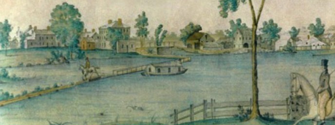
Masthead - Excerpt from a watercolor painted by Jabez Ward Barton, ca. 1825, entitled View from William Rogers House. Shown, looking west, may be the packet boat George Washington being towed across the Concord River from the Floating Towpath at North Billerica.
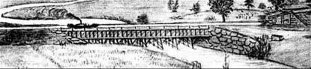
Back Page - Excerpt from an August 1818, drawing of the Steam Towboat Merrimack crossing the original Medford Aqueduct (artist unknown).
Canal Game and Puzzle - The National Canal Museum has made a canal related game and a puzzle available on their web site http://www.canals.org/funandgames/. These include: a Boat Captain's Game - Can you run a canal shipping business successfully? And a Canal Lock Puzzle - would you know how to construct a canal lock and make it work? Give them a try.
Towpath Topics is edited by Bill Gerber and Robert Winters.
Corrections, contributions, and ideas for future issues are always welcome.