
Middlesex Canal Association P.O. Box 333 Billerica, Massachusetts 01821
www.middlesexcanal.org
| Volume 50 No. 2 | January 2012 |
MCA ACTIVITIES
Mark your calendars! The Winter Meeting will be held at the museum on Sunday, February 12th, beginning at 2:30 PM. Mr. Gray Fitzsimons, will highlight the history of the Lowell Bleachery and the Wamesit Power Company's Canal, and will describe the relations between a company, composed largely of outside investors, with the locally held Wamesit concern.
A Middlesex Canal Bicycle Ride will be conducted on Sunday, April 1, along the length of the canal, from Middlesex Village to Charlestown.
The MCA-AMC Spring Walk will take place on Sunday, April 15, in North Billerica and Chelmsford.
The MCA Annual Spring Meeting will take place on Sunday, April 29, in the museum, at 1:00 PM. The program is yet to be developed, but the election of officers will occur at that time.
See the Calendar, following, for more information on our activities. Also included in the calendar are meetings and tours, sponsored by other organizations, in which you may want to participate. Please also check our web site periodically, at the URL noted above, which often lists canal-related events and topics of potential interest.
PRESIDENT'S MESSAGE
by J. Jeremiah Breen, jj@middlesexcanal.org
"Mapping Thoreau Country" is a project of the Thoreau Society and UMass Lowell. On Sunday, September 1, 1839, John and Henry Thoreau entered the Middlesex Canal from the Concord River at the Billerica Dam and towed their 15' boat to the Merrimack "in little more than an hour". The Thoreau towpath, river-to-river, is five miles, twenty chains, and 66 links (5.26mi), based on the Baldwin 1829 Survey. The MCA's regularly scheduled walk from the iron rings at the Concord River to the MC monument at Riverneck Road is 2.33mi, 44% of the Thoreau path. Three easements and a gift of 1.38 acres cover parts of the 2.33mi.
 |
Courtesy, Chelmsford Historical Society Samuel P Hadley, Locktender, |
The 1.38 acres is along Lowell Street, halfway between Boston Road (Route 3A) and the Billerica fire station. Lowell Street parallels the former towpath. A MCA proprietor bushwacked from near Boston Road to the fire station on the berm side and reported that the canal construction is clearly identified by the 5' berm with the canal on the south and the declivity to the wetland on the north. The ruins of a culvert passing under the canal are also identifiable from the berm. A walk on the berm would be a much better re-creation of the Thoreau experience than walking Lowell Street. The Association is doing a title search on what looks to be only two non-MC bermside property owners, one of whom has agreed to grant us an easement.
At the Merrimack end of the Thoreau towpath, the canal, its aqueduct, and locks are gone. There is a MC monument in Hadley Field, 700' south of the 3-lock staircase where the locktender (possibly Samuel Page Hadley, father of Judge S. P. Hadley) let the Thoreaus down into the river.
Today, the south bank is made inaccessible by the railroad, but the north bank, where the Thoreau's might have made their "nooning" "opposite the Glass-house village", though not "at the Great Bend", has a monument opposite the canal. (The monument is a memorial to Scotty Finneral, a sailor who died at the end of the first Iraq war.) It marks the location on the river wall opposite the canal where the Association is working on permission from the MA Dept. of Conservation and Recreation for a MC bronze plaque. The plaque will emphasize that the canal was part of a transportation system extending to Concord, NH.
Tom Raphael had a utility coordination meeting November 8, 2011 at the museum for the MC Park at the Billerica millpond, which includes the Thoreau towpath between the Concord River and the firehouse. Much of the MC has been saved and made usable in the fifty years since Harry Lasher's talk at the Billerica Historical Society led to the founding of the Association.
The Association has agreed to pay $1,600 per month rent for the next two years for the museum, a daunting $19,200 per year. An anonymous donor will match, dollar-for-dollar, donations up to $10,000. Now is the time to be more generous.
The death of Dave Dettinger brought to mind a kindness with which he welcomed me after I joined the board of directors. He offered to loan me two books, The Canal Builders and Common Labor. I resisted the offer, having plenty of other reading I was sure I wanted to do. Later, after knowing more of his manifold contributions to the excellence of the MCA and how large his canal book collection must be, I understood how thoughtful his choice of those two books was. Dave gently persisted in the offer. In the years since, he never reminded me to return them. An exceptional man.
J. Jeremiah Breen
TABLE OF CONTENTS
MCA Activities
President's Message (Breen)
Calendar of Events
Our Fall Walk - October 2011 (Roger Hagopian, Howard Winkler)
Community Involvement (Bill Gerber)
Remembering David Dettinger (Bill Gerber)
The Baldwin Dry Docks (Howard Winkler)
Canal and River Navigation Locks (Bill Gerber)
Sustenance, A Question (Bill Gerber)
The World Canals Conference (Tom Raphael)
CALENDAR OF EVENTS
Middlesex Canal Association (MCA) and related organizations
First Wednesday - MCA Board of Directors' Meetings - The Board meets at the Museum, from 3:30 to 5:30pm, the first Wednesday of every month, except July and August. Members are always welcome to attend.
Sun, Feb 12, 2012, 2:30 PM - MCA Winter Meeting: Uneasy Partners: Wamesit Power Company and the Lowell Bleachery, a talk by Mr. Gray Fitzsimons, Member of the Board of Directors of the Lowell Historical Society and former Historian for the National Park Service in Lowell.
One of the earliest of Lowell's large-scale textile companies, the Lowell Bleachery was established in 1832 not along one of the major power canals or waterways, but instead along Hale's Brook, a small tributary of the Concord River. The Bleachery is very likely the least studied of any of Lowell's large textile concerns and its relationship to the Wamesit Power Company, organized in 1865 out of the industrial enterprises of local capitalist Oliver Whipple, has never been explored. This presentation will highlight both the history of the Lowell Bleachery and the Wamesit Power Company's Wamesit Canal, and will examine the relations between a company, composed largely of outside investors, with the locally held Wamesit concern. As will be seen, a lawsuit in the 1880s over the Wamesit Power Company's legal requirement to upgrade the Wamesit Canal and hydro-mechanical works, sheds a great deal of light not only on the Wamesit system, but also on the relationship between Wamesit Company, the Bleachery, and the other industrial concerns served by the Wamesit Canal.
Directions to the Museum/Visitors Center: Telephone: 978-670-2740.
By Car:
From Rte. 128/95, take Route 3 toward Nashua, to Exit 28 "Treble Cove Road, North Billerica, Carlisle". At the end of the ramp, turn left onto Treble Cove Road toward North Billerica. At about ¾ mile, bear left at a fork. After another ¾ mile, at a traffic light, cross straight over Route 3A. Go about ¼ mile to a 3-way fork; take the middle road, Talbot Street, which will put St. Andrew's Church on your left. Go about ¼ mile and bear right onto Old Elm Street. Go about ¼ mile to the falls, where Old Elm becomes Faulkner Street; the Museum is on your left and you can park across the street on your right, just beyond the falls.
From I-495, take exit 37, N. Billerica, south to the road's end at a "T" intersection, turn right, then bear right at the Y, go 700' and turn left into the parking lot. The Museum is across the street.
By Train: The Lowell Commuter Line runs between Boston's North Station and Lowell's Gallagher Terminal. Get off at the North Billerica station, which is one stop south of Lowell. From the station side of the tracks, the Museum is a 3-minute walk down Station and Faulkner Streets on the right side.
Mar 3, 2012 - Canal Society of New York State Winter Meeting and Symposium, Rochester, NY. For details, visit www.newyorkcanals.org.
Sun, Apr 1, 2012 - Spring Middlesex Canal Bicycle Ride. Meet 9:30 AM at North Station (commuter rail) and take our bicycles on the 10 AM train to Lowell. (Riders can also board at West Medford at 10:11 or meet the Train when it arrives in Lowell at 10:43). Route visits the Pawtucket and other Lowell canals, the river walk, Francis Gate, and then Middlesex Canal remnants in Chelmsford. Lunch at Route 3A mini-mall in Billerica. Quick visit to Canal Museum, then on to Boston. Long day, but sunset is late. Riders needing to leave early can get the train to Boston at 1:07 at North Billerica or at 3:14 at Wilmington. Participants are responsible for one-way train fare [$6.75 from Boston to Lowell]. Complete Lowell line schedules can be downloaded at www.mbcr.net if anyone wishes to plan a rail travel itinerary specific to their needs. For any changes or updates, see middlesexcanal.org. Leaders Bill Kuttner (617-241-9383) & Dick Bauer (857-540-6293).
Apr 13-15, 2012 - Canal Society of Indiana 30th Anniversary Tour, headquartered in Batesville, IN. Bus & Whitewater Valley Railroad tour of Whitewater Canal locks and dam (Connersville to Brookville). Visit Whitewater Canal headquarters, Gateway Park, Yellowbank Lock 21, railroad shops and yard. Meals at historic Laurel Hotel and Sherman House. Teddy Roosevelt re-enactor on NY and Panama canals. Leaders are Bob & Carolyn Schmidt, (indcanal@aol.com).
Sun, Apr 15, 2012 – Joint MCA-AMC Middlesex Spring Canal Walk, N. Billerica. (rain date Sun, Apr 22) Level 5-mi. walk along historic canal N to Chelmsford, 1:30-4pm. Meet at the Middlesex Canal Museum (opens at noon). From Rt. 128/95, take Route 3 toward Nashua, to Exit 28 "Treble Cove Road". End of ramp, turn L toward North Billerica. At about ¾ mile, bear L at a fork. At traffic light, cross over Route 3A. Go thru "S" to a 3-way fork; take Talbot Street (straight ahead, which puts St. Andrew's Church on your left). Go about ¼ mile and bear R onto Old Elm Street, which becomes Faulkner Street. Go about ¼ mile to the falls at the dam; the Museum is on your left, park across the street. No registration required. Info: www.middlesexcanal.org or Roger Hagopian (781-861-7868 to 10pm). L Robert Winters (617-661-9230; Robert@rwinters.com).
April 20-22, 2012 - Pennsylvania Canal Society Spring Field Trip, Delaware & Hudson Canal. Contact: Bill Lampert (indnbll@yahoo.com).
Sun, April 29, 2012 - MCA's Annual Spring Meeting will take place in the museum, at 1:00 PM. The program is yet to be developed, but the election of officers will occur at that time.
May 4-6, 2012. Virginia Canal & Navigation Society (VC&NS). Celebrate the Bicentennial of Chief Justice John Marshall's 1812 survey over the Alleghany (sic) Mountains to connect navigation on the James River, with the Ohio River via the Kanawha Canal. This route would ultimately become the C&O Railway's route. The VC&NS and the C&O (Railway) Historical Society & Archives are partners for this grand event. www.vacanals.org.
June 22-24, 2012 - The Canadian and the American Canal Societies' Historic Canals Conference, Hamilton, Ontario will examine the Desjardins Canal (which will be celebrating its 175th anniversary), the Burlington Ship Canal, and Hamilton Harbour and environs. L Bob Sears (416-285-7254; dawnofdestiny@sympatico.ca).
Jun 30, 2012 - Canal Society of New Jersey, Waterloo Canal Day at Waterloo Village. Music, boat rides, games, displays, tours. 11-5. Free, but donations are welcomed. Also Canal Heritage Days will be held at Waterloo on the 2nd and 4th Saturdays in July, August, September and October.
Sept, 2012 - World Canals Conference, Yangzhou, China. See www.worldcanalsconference.org for details.
Sept 30 - Oct 2, 2012 - Canal Society of New York - Canal Conference, Oswego, New York. For details, visit www.newyorkcanals.org.
Oct 3-15, 2012 – Canal Society of New York - Canals and Waterways of Belgium – For details, visit www.newyorkcanals.org.
Oct 14-16, 2012 - Canal Society of Indiana - Fall tour on the Hennepin Canal, Headquartered in Moline, IL. (indcanal@aol.com)
Sept, 2013 - World Canals Conference in Toulouse, France. See www.worldcanalsconference.org for details.
Our Fall Walk - October 2011
by Roger Hagopian, with contributions by Howard Winkler
Our walk commenced at Winchester, where the remnants of the Middlesex Canal meanders from the land of the Department of Conservation and Recreation to the streets and neighborhoods of Medford. As usual our walkers, which numbered about 30, consisted of a mix of historians, nature lovers, bird lovers, and fitness folk.
Led by co-leaders Robert Winters and Roger Hagopian, the group proceeded from Sandy Beach on the Mystic Lakes in Winchester to the site where an aqueduct once carried the canal over the Aberjona or Symmes River at the north end of the upper lake. During the canal era this was location where the river entered into the lakes. However, in 1864, a dam was constructed between the Upper and Lower Lakes, once known as Medford Pond, thus elevating the water level for conversion into a reservoir for the city of Boston's drinking water supply. As a result, the Aberjona/Symmes River has now taken the form of a smaller third lake just above the aqueduct site.
In 1866 the aqueduct was blown up to relieve ice jams created by the stone arch structure. Its remains were used in the construction of the house and stable of the nearby Shepard Brooks estate, as well as a barn on the Brooks family estate. The remaining stones lie scattered in the Winchester Town Forest and at the base of the aqueduct site, where some were reused when the Metropolitan District Commission built an overlook platform there.
Not far from the aqueduct was a canal basin for packet boats and barges awaiting their turn to cross the narrow trough. The semi-circular depression is still clearly visible.
Based on an article in the New England Magazine, 1898, and a map of the installation of the sewer line between Medford and Winchester, it is clear that the pipes had been laid in the bed of the Middlesex Canal with manhole covers sporadically marking the route. Realizing that the canal, the Boston and Maine Railroad (formerly Boston and Lowell), the parkway, built in the 1890s, and the sewer line all occupied the same strip of land along the eastern shore of the Mystic Lakes, our group of walkers traced the course of the canal to Medford.
We never quite made it to the Mystic River, our intended terminus, and, perhaps in the future we will arrange to have a car shuttle as we have in the past, to avoid the redundancy of retracing our steps.
Recent MCA Activities and Community Involvement
by Bill Gerber, with multiple inputs
In recent months, members of the committee were active in a number of events, several MCA initiated and others sponsored by local communities.
In early September, Neil Devins and Russ Silva established MCA's presence at Wilmington's Library Community Fair, for which, gratefully, the otherwise rainy weather cooperated quite well. Though sales of MCA books was light, there was considerable interest from the community. Many children and parents commented on their school's annual spring field trips to our museum and to Maple Meadow Brook Aqueduct and the extant canal section adjacent to the town park. A Christian school inquired about adding similar visits to their curriculum, and Wilmington Access TV asked about the availability of material suitable for local broadcast.
In mid-September, as part of Concord River Day celebrations, our museum was honored to host Massachusetts' Representative Niki Tsongas for a Meet-Your-Representative event. Congresswoman Tsongas is a member of the Natural Resources Committee. She selected this day to emphasize the importance of the rivers in the Fifth District. MCA VP Traci Jansen, coordinated the visit arrangements with Jane Adams (Ms. Tsongas' regional coordinator) on behalf of the Association and led the tour of the museum for the Congresswoman and her four staffers. A significant number of Billerica students and Girl Scouts were in attendance. Assisting Traci were J. Breen, Tom Dahill, Bill Gerber, and Alan Seaburg. A large map of the Concord, Sudbury, and Assabet Rivers (from an 1861 engineers' report,) was posted for the tour. During the visit, Ms. Tsongas awarded Congressional Certificates of Achievement to several of the students and Girl Scouts who had studied water quality, and to Traci a Certificate of Special Congressional Recognition "in appreciation of your efforts to educate children on the historical significance of the Middlesex Canal and your gift of bringing local history to life". The Association presented Ms. Tsongas with a copy of The Incredible Ditch, a history of the canal authored by Carl and Alan Seaburg and artist Tom Dahill for the canal's bicentennial. Alan and Tom signed the book. The Association is honored to have had Ms. Tsongas as a visitor to our museum.
At the beginning of October, Dick and Roberta Bauer led the annual Fall Bicycle Ride along the Middlesex Canal from Sullivan Square to North Billerica. Despite rain early in the day and again in the afternoon, more than a dozen riders took part. After many stops along the way to look at remnants of the Canal, including restored and watered sections, lockkeepers' houses, the ox-bow in Wilmington (where you can still see the grooves that the tow-ropes cut in one of the boulders), and the aqueducts at Maple Meadow Brook and the Shawsheen River, the ride finished at the Museum in North Billerica. Tom Raphael, the Chair of the Middlesex Canal Commission, met the ride at our Horn Pond stop in Woburn. Their return to Boston was via the Lowell commuter train; Mass Bay Commuter Railroad put a bike-car on the Lowell line specifically for the ride.
In mid-October Roger Hagopian and Robert Winters led the annual joint MCA-AMC Fall Walk, this time along the canal remnants in the Winchester/ Medford area. Included was a visit to the site of the Mystic River aqueduct.
Throughout October, in concert with Massachusetts' Archeology Month, J. J. Breen, Tom Dahill and Bill Gerber provided two special exhibits at the Canal museum. These consisted of:
The Great Billerica Dam Controversy of 1860, the focus of the Report of the joint special committee on the subject of the flowage of meadows on Concord and Sudbury Rivers. The title of the exhibit is taken from the 1982 Towpath Topics article, "The Great Billerica Dam Controversy" by Arthur L. Eno, available at http://middlesexcanal.org/towpath/towpathtopicsApr1982.htm.
Artifacts from a Canal Tavern. While adding a garden and orchard to his home, adjacent to the the site of Tay's Tavern, former Woburn Selectman John Ciriello uncovered many artifacts from this canal era tavern. Through the generosity of the current owner, Margaret MacLeod, the Tay's Tavern collection was on display throughout the month.
In late October, Tom Dahill, Traci Jansen, Betty Bigwood and Bill Gerber, assisted by new member Brett Holladay, erected our canopy at the Condon Shell in Medford to participate in a Mystic River Celebration, sponsored by Medford's new Coalition of Arts, Culture and a Healthy Economy. For this and future events, Tom D. constructed a frame of PVC pipe which was used to exhibit art and photographs of the canal in Medford. The resulting exhibit was well received by all who visited our site. Betty B. fed and hydrated us during the long day; thank you Betty. The celebration organizers did quite a wonderful job of organizing young volunteers to assist the various exhibitors and vendors to assist with "sherpa functions" and the set up and tear down phases, for which we were much appreciative.
At the end of October, Bill Gerber presented his "Canals of the Merrimack River" talk to members of the Society for Industrial Archeology, Northern New England Chapter, at their Fall Meeting and Field Trip, hosted by the Manchester Historic Association at the Millyard Museum. MHA Executive Director Aurore Eaton led a walking tour of the extant parts of the Amoskeag Canal and Mark Boucher, of Public Service, led a tour of the dam. Photos of the tour can be seen at http://www.meetup.com/Manchester-History-Network/photos/4948932/79675712/.
In early November, Tom Raphael gave a talk entitled "The Middlesex Canal In Winchester" to the Winchester Historical Society, at the Sanborn House. A week later Tom opened the MCA Fall Meeting, preceding the main speaker with an account of his and his daughter's trip to the 2011 World Canals Conference in the Netherlands.
Our Fall Meeting was held at the museum in early November. Jeff Ellis recounted his participation in the 13th running of "Cycling the Erie Canal". This 400 mile tour began in Buffalo, NY and ended 8-days later in Albany; two-thirds taking place on the completed portion of the Canalway Trail System. Jeff had sought out canal-related features all along the route.
As part of their approval of a Condo development for Main Street in North Woburn, the planning board required the developers to build a walking trail along the Middlesex Canal at the rear of the property. Hopefully their work will be consistent with plans developed by the Middlesex Canal Commission. More information can be found at http://www.wickedlocal.com/woburn/features/x885897900/Condo-development-approved-for-Main-Street-in-North-Woburn#ixzz1hGfW3Awo.
Remembering David Dettinger
by Bill Gerber
 In the September issue we noted the passing of Wil Hoxie and Bruce McHenry, two members of our Board of Directors who, in their time, contributed greatly to our knowledge of the Middlesex Canal and our ability to inform our members and the general public. Sadly one more very productive member of the Board, Dave Dettinger, has since joined them.
One friend commented: "He was one of the nicest and most decent men you could ever know."
Dave was born 1919, in Little Falls, NY; he died October 03, 2011 at age 92. A graduate of St Lawrence University, he attended graduate school at MIT, however wartime employment lead him to take a job at the Hazeltine Electronics Corporation in 1942 where he worked on the design of RF antennas and components for IFF systems. From 1947-1961 he was Chief Engineer at Wheeler Laboratories, a company nationally recognized for its creative achievements in microwave and antenna design. Dave next moved to Massachusetts for a career in telecommunications system engineering at the MITRE Corporation in Bedford. Later, he joined the company's education office, the MITRE Institute, where he helped advance the technical education of engineers and scientists.
He led a full and active life, and kept diaries throughout. He was -
Athletic: he enjoyed bicycling, hiking and ice skating, and was always up for a good game of volleyball.
Musically inclined: he sang with a barbershop quartet, organized quartets within his church, played the tuba and is known to have written at least three songs, one about the Middlesex Canal. (Hear it at http://middlesexcanal.org/media/HaulinDownToBoston.mp3.)
Very involved with his church: it's said that he was even known to critique the Sunday sermons. (Did I say that he was courageous too?) He also researched the origin of the bell of his church, which was acquired from a church in Boston. (Weighing two tons, the bell was cast by Henry Northey Hooper in Boston in 1844.)
Dave was a long-time member of the Middlesex Canal Association and its Board of Directors and served as its Vice President from about 1987 to 1991. He researched and lectured, and contributed to Towpath Topics as well, about: James Sullivan, President of the M'sex Canal Company and later Governor of Massachusetts (TT - 9/1999); the Pawtucket Canal (TT - 4/1998); the Baldwin family's myriad engineering achievements (TT - 3/2000 & 4/2009); trips to, along and on other canals in this country and in Europe; Boats and Boating on the Middlsex Canal (TT - 3/1999); and a number of other topics. He was the foremost researcher of the Mill Creek Canal, which bisected Boston (passing through Haymarket Square and linking Boston Harbor with the Charles River. For a succinct report of this work, see http://middlesexcanal.org/towpath/towpathtopicsMar2008.htm). For the Bicentennial Decade, Dave was the prime mover, principal writer and choreographer for a series of plays to commemorate the 200th anniversary of the development and opening of the Middlesex Canal. In addition to writing and acting in the plays , he conceived the idea for a ten year celebration of its construction by finding speakers and presenting his own programs.
In early June, 2010, Betty Bigwood, Jean Potter, and a crew of many organized a gala party to celebrate Dave's 91st birthday.
The Baldwin Dry Docks
by Howard Winkler
Loammi Baldwin, Jr., the son of Loammi Baldwin and considered to be the Father of American Civil Engineering, was the engineer who prepared the plans for and was in charge of construction of the dry docks at Charlestown Navy Yard in Massachusetts and Gosport Navy Yard in Virginia. (In 1862, after Union forces captured the Gosport Navy Yard, its name was changed to the Norfolk Navy Yard.)
As early as 1798, the Navy recognized that the practice of heaving a ship on its side for maintenance was time consuming and dangerous. It required that the upper masts to be taken down, the guns, stores, water casks, ballast, and ammunition, be removed, and it caused the workmen to tend to their duties in an awkward position. With a dry dock, maintenance can be performed with the ship in an upright position. A dry dock can be thought of as canal lock that is closed at one end with the other end open to the sea. A ship is floated in, the gates are closed, and the water is pumped out.
In 1826, Congress passed a resolution requiring the President to have "a skilful engineer" conduct a detailed survey of the possibility of constructing a dry dock at either the Portsmouth (New Hampshire), Charlestown, Brooklyn, or Gosport Navy Yards. In anticipation of this resolution, Secretary of the Navy, Samuel L. Southard, had already been in contact with Loammi Baldwin, Jr. In 1827, funds were appropriated by Congress for the construction of two dry docks of similar design at Charlestown and Gosport Navy Yards.
Baldwin had observed examples of functioning dry docks in England and Antwerp during visits in 1807 and 1824. His engineering credentials included designing one of America's first steam-powered fire engine pumpers, extending Beacon Street beyond the Boston Common into the Charles River marshes, supervising parts of the design and erection of the Bunker Hill Monument, overseeing numerous public works projects in Virginia, designing Pennsylvania's Union Canal, preparing proposals for a canal from Boston across Massachusetts to New York State, connecting with the Erie Canal, and a tunnel through the Hoosac Mountains. Prior to working on the dry dock project, he was a consulting engineer in the review of the Charlestown shipyard facilities.
Baldwin appointed Alexander Parris, the noted Boston architect known for his use of granite, as his principal assistant at Charlestown, and Captain William P. S. Sanger of the Navy to a similar position at Gosport. During the following seven-year construction period Baldwin divided his time between the two sites, overseeing construction in Boston during the summer months and residing at Norfolk during the winter. In each case his appointed assistant was in charge during his absence.
The docks measured 314 feet in length, 100 feet in width, and 32 feet in depth. Granite from the Quincy quarries was hauled to the Neponset River terminus on the Granite Railway, another notable civil engineering achievement of the time, whereupon it was barged to the Charlestown site or shipped by sea to Norfolk. When completed, each dock contained 500,000 cubic feet of Quincy granite.
On June 17, 1833, the anniversary of the Battle of Bunker Hill, the USS Delaware was dry-docked at Gosport Navy Yard. One week later, on June 24, the USS Constitution was dry-docked at the Charlestown Navy Yard. When the last details of construction were completed in 1834, a total of $677,000 had been spent for the Charlestown dry dock, excluding Loammi Baldwin's salary of $4,000 per annum. The Gosport dry dock showed a price tag of $945,000. The difference arose primarily from the cost of shipping granite from Quincy and of importing and housing skilled labor from the North, required to complete the installation. (The estimated 2010 costs would be about $404,000,000 for the dry dock in Charlestown, $564,000,000 for Gosport.)
The photos of the headwall of the Charlestown dry dock were taken in September 2011 by the author from the deck of the USS Cassin Young which was in Dry Dock No. 1, the Baldwin Dry Dock. The photo of the headwall at Norfolk was provided by Stephen P. Carlson, Preservation Specialist, Boston National Historical Park.
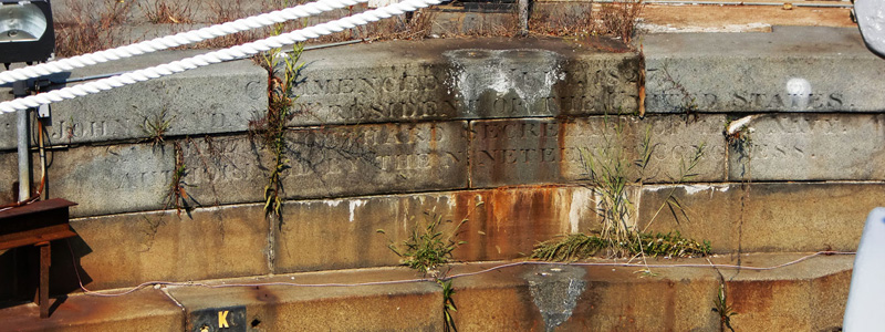
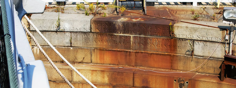
The words engraved on the headwall in Charlestown are
COMMENCED ON 10th. JULY. 1827
JOHN Q. ADAMS PRESIDENT OF THE UNITED STATES.
SAMUEL L. SOUTHARD SECRETARY OF THE NAVY.
AUTHORISED BY THE NINETEENTH CONGRESS.
OPENED 24th. JUNE. 1833
ANDREW JACKSON PRESIDENT OF THE UNITED STATES.
LEVI WOODBURY SECRETARY OF THE NAVY.
LOAMMI BALDWIN ENGINEER.
and in Norfolk
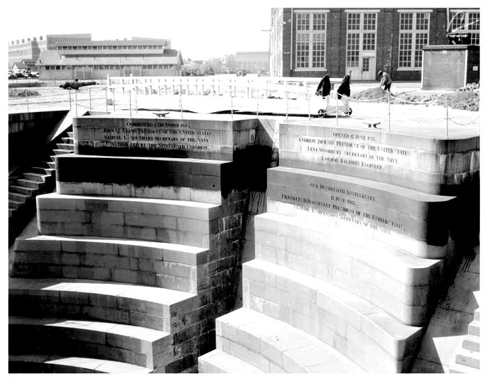
COMMENCED ON 1. DECEMBER. 1827
JOHN Q. ADAMS PRESIDENT OF THE UNITED STATES.
SAMUEL L. SOUTHARD SECRETARY OF THE NAVY.
AUTHORISED BY THE NINETEENTH CONGRESS.
OPENED 24th. JUNE. 1833
ANDREW JACKSON PRESIDENT OF THE UNITED STATES.
LEVI WOODBURY SECRETARY OF THE NAVY.
LOAMMI BALDWIN ENGINEER.
ONE HUNDREDTH ANNIVERSARY
JUNE 17, 1933
FRANKLIN D. ROOSEVELT,
PRESIDENT OF THE UNITED STATES
CLAUDE A. SWANSON, SECRETARY OF THE NAVY
The Commenced and Opened inscriptions were placed on the docks at the time of their completion. The additional inscription on the Norfolk dock was added in 1933 for its centennial.
Bibliography:
* Daniel K. Schodek, Landmarks in American Civil Engineering, 1987.
* Stephen P. Carlson, Preservation Specialist, Boston National Historical Park, Dry Dock No. 1, Charlestown Navy Yard, www.hnsa.org/conf2004/papers/carlson.htm and private communications.
* Blatt, Martin, Chief of Cultural Resources/Historian, Boston National Historic park, private communication.
* Measuring Worth, Seven Ways to Compute the Relative Value of a U.S. Dollar Amount - 1774 to Present, www.measuringworth.com/uscompare.
CANAL AND RIVER NAVIGATION LOCKS OF EASTERN
MASSACHUSETTS & SOUTH-CENTRAL NEW HAMPSHIRE
by Bill Gerber
Not at all surprising, the Middlesex Canal Association focuses most of its time, energy and resources on the Middlesex Canal itself. However, by 1815, the M'sex constituted only about a quarter of the extensive length of canals and river navigations operating in Eastern Massachusetts and South-Central New Hampshire. The table on the following page tallies the overall system's more than five-dozen locks, of various functions and lift capacities, with notes indicating when they were built and the company that built and operated them.
The Middlesex Canal incorporated 20 of the initial locks, a number that grew to 24 in later years. Ignoring Master's (aka Harvard) Canal, which opened circa 1635, the Middlesex was the second significant canal constructed; the Pawtucket Canal being the first. Though certainly the largest and the most ambitious, the Middlesex Canal Company, itself, was only one of the more than a dozen private, independently financed companies that built the system. But being the largest, it invested in most of the other companies and exerted control over many of them.
The details of the construction and operation of the major components of the system have been described in prior Towpath Topics articles; see http://middlesexcanal.org/towpath/. Mill Creek, the canal that bisected Boston, was written up in March 2008; the Canals of the Merrimack in January 2009; and the East Cambridge and Cambridgeport Canals in October 2009. Additional related articles can be found in other issues, check the index accessible at the URL cited.
After 1815, the principal additions to the canal system included the Nashua Boat Canal, which opened in 1826; a guard lock into Horn Pond which must have been constructed between 1826 and 1829, and Red lock, in North Billerica, opened in 1837, which made the lower portion of the Concord River accessible to navigation, possibly as far as the south end of Centennial Island in Lowell (the upper portion, 10+ miles, was opened in 1808/09). This final construction was completed two years after a railroad began operation between Boston and Lowell. Subsequent railroads reached Nashua in 1838 and Concord NH in 1842, ultimately "mortally wounding" the canal network and some of the businesses that used it.
| Canal Name | Arrangement | Initial | Additions |
| Built by MCC (3) - (20 locks were constructed as part of the initial M'sex Canal building effort. Later, several more were added.) | |||
| Merrimack Flight | 1 - 3-lock staircase | 3 | |
| Concord Crossing | guard, (1E & 1W) | 2 (conv. to "raft locks") | |
| Nichol's | single | 1 | |
| Gillis' | single | 1 | |
| Stoddard's | 3 - 2-lock staircases | 6 | |
| Horn Pond | guard (added ca 1829) | 1 | |
| Stone's | single | 1 | |
| Gardner's | 1 - 2-lock staircase | 2 | |
| Gilson's | single | 1 | |
| Malden Road | single | 1 | |
| Mill Pond | single | 1 | |
| Charles River | tidal | 1 | |
| Wicasee | single (added ca 1815) | 1 | |
| Red Lock | single (added ca 1837) | 1 | |
| Sub totals | 20 | 4 | |
| Canals, constructed by other companies - From North to South, as follows: | |||
| Bow Canal (8) | 1 - 3-lock staircase & 1 guard gate | 4 | |
| Isle of Hooksett (9) | 1 - 2-lock staircase & 2 guard gates | 3 | |
| Blodget's (4) | unknown (opened 1807, repl. in 1815) | 9 | |
| Amoskeag (13) | 1 - 4-, & 1 - 2-lock staircases & 1 guard (opened ca 1815) | 7 | |
| Piscataquog Branch (11) | 1, possibly 2 locks | ~1 | |
| Union Canal (10) | 7 in six by-pass canals (opened 1813/15) | 7 | |
| Cromwell Falls (12) | 1 (opened 1815) | 1 | |
| Nashua Boat (14) | 1 x 4-lock staircase (+1 guard?, 1824) | 4 (+1?) | |
| Pawtucket (2) | various | ~5 | |
| Medford Branch (5) | 1 lift +1 tidal (opened 1805) | 2 | |
| C'town Prison Branch (15) | none known | ||
| Camb & E Camb (7) | none known | ||
| Masters (aka Harvard) (1) | none known (ca 1635) | ||
| Mill Creek/Cross Boston (6) | none known (ca 1805) | ||
| Sub totals | ~37 -> ~35 | ||
| Total | ~61 -> ~64 | ||
Legend:
(#) Chronological order, by private company that built each canal cited.
(~) Best guess, in absence of documentation, or where the # varied over time.
SUSTENANCE FOR BOATMEN AND TRAVELERS – A QUESTION
by Bill Gerber
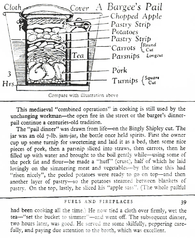
An article in the recent issue of "Waterways World", an English publication, raised a question particularly relevant to our own network of canals and river navigations. The article described a "Bargee's Pail", a clip from which is shown here.
 The question is obvious, what did our own boatmen do to sustain themselves while traveling? At the extreme, the duration of a round trip between Concord NH and Boston MA averaged nine days, four down and five up; between nearer points, of course, trip durations would have been shorter.
Unlike those on other US canals, our boats were relatively small and primitive and, to the best of my knowledge, no one lived aboard; also no "galley" descriptions have ever been found. For the most part, our 120+ miles of canals and river navigations were served by an infrastructure of taverns and dual-purpose lock tender's houses which together provided quarters, and for sustenance and socialization. (No more than four boatmen allowed per bed!) But, no doubt, use of these facilities would add to the cost of travel. While these facilities may well have provided the evening meal, and perhaps a breakfast too for many boatmen and travelers, I seriously doubt that they were used by all, particularly those who traveled constantly, or that they accounted for all en-route dining provisions, particularly the mid-day meal.
The author of the British article states: You might remember a fascinating BBC TV programme that aired earlier this year, called 'The Golden Age of Canals'. It gave the story of the tail-end of commercial carrying on the canals, told mainly through home movie footage, with assorted 'talking head' interviews with witnesses to the era. The producer of that fine programme, David Parker, writes that he's now making a TV programme about 'traditional food', and adds: "I've come across a way of cooking called the 'Bargees Pail'. Have you ever heard of it, and do you know anybody who can simulate it on a narrow boat today? I'd like to find someone cooking in this style if at all possible. Any advice would be gratefully received."
The "Bargee's Pail", described in the clip above, reminds me of my grandparent's "Fireless Cooker". This was an insulated chest about the size of a large picnic cooler. It included a slab of iron, about the size of the bottom of the chest, which could be heated on the top of a wood stove (aka cook stove). Once heated, it was moved to the bottom of the chest, a few towels were placed on it, and food, e.g., meat, potatoes and vegetables to be cooked, each in its own container, were all placed on the slab and the chest was tightly closed. This was an early Sunday morning ritual, after which the family went off to church. By the time they returned, hours later, their Sunday noon meal was cooked and ready to eat.
I've sometimes used a "Fire Pit" on camping trips, in which rocks were heated in an open fire. When hot, any remaining coals and the rocks were shallowly covered, food was added above the hot rocks, and the pit was filled in. A few hours later a well cooked hot meal was available for all to enjoy. I've also used reflector ovens and dutch ovens with acceptable success.
Certainly hot rocks retain heat for a long time and could readily be substituted for my grandparents' iron slab, and this might have conveniently served sustenance needs. But, did any of the boatmen and travelers employ similar or comparable means? I haven't a clue! Do any of our readers know? (wegerber@gmail.com)
Report on the World Canals Conference Groningen, The Netherlands September 19-14, 2011
by Thomas Raphael
My daughter, Connie, and I set out on Saturday September 17, by way of Amsterdam, for the city of Groningen in the Netherlands for the World Canals Conference (WCC) 2011. These conferences are held annually on a three year cycle, in America, Europe and Asia. Their locations are selected by the Inland Waterways International (IWI) Organization and hosted by special committees in each country.
The object of these conferences is to bring together government, commercial, technical and other organizations interested in inland waterways development. Delegates and speakers come from all over the world to publicize their activities and to meet and learn from the experience of others.
This conference in the Netherlands was organized by the National Heritage Department, the Provinces of Groningen, Drenthe and Friesland and supported by the Dutch Foundation for Recreational Waterways. Today, the Dutch are trying to persuade everyone in the world to call the country "The Netherlands" and not "Holland", since Holland is really only one area along the coast. The early Dutch traders were mostly from Holland, they have played a major role in international trade since the 17th century and brought great wealth to their country.
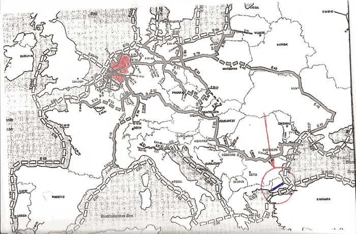
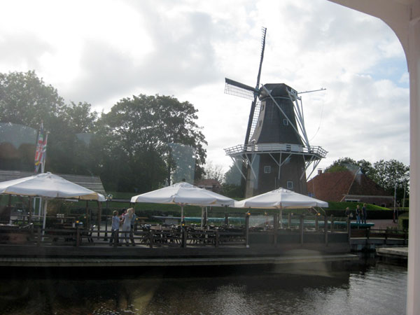
The Netherlands are in the northwest corner of Europe (see map), and are very flat. The highest land is in the southeast and is only 3 meters above sea-level. About 60% of the land, mostly near the coast is below sea-level, protected by an elaborate system of dikes and lock gates. The land was originally reclaimed from mud flats by building dikes and by pumping the land dry. After several years, the rainfall washed out the salts and left the wonderfully fertile fields. This required the digging of a network of canals to control the water needed for drinking, irrigation, industry, flood control, transportation and disposal. The canals, with their locks and bridges crisscrossing the country and the canal boats were and are again becoming major means for all transportation.
The lands are kept dry by windmills and electric pumps, operated by the National Water Board which controls all the water in the canals in the country whether from rain or the many rivers. All of these, and the mighty Rhine, empty by way of the ports of Amsterdam and Rotterdam.
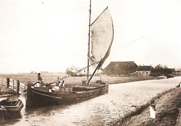
We flew from Logan International Airport Saturday evening, arriving Sunday morning in Amsterdam and took a train to Groningen. After checking into our hotel we took off for the welcoming parade of old and new boats in the downtown canals. We then went to the Noordelijk Scheepvaart (marine) Museum where we met several of our fellow travelers, had a light dinner and a concert and reception. There was a reconstructed canal boat, common throughout the country, powered by sail and housing the crew which was often the family home.
Monday morning, we were welcomed by the Provincial Delegate, the Mayor and the conference chairman and organizer. At exactly 12:00 noon, we left by bus, with box lunches, for a tour to the Province of Drenthe. This area has an abundance of canals which were constructed for the large-scale industrial peat extraction since the Middle Ages. The canals were used for transportation and as bogs were developed the complex branching of the canals has determined the spatial planning characteristic of the northern provinces. Peat was transported and sold broadly through the Netherlands and Germany before the mining of coal.
With the coming of the automobile and the development of roads, countless bridges have become more and more obstacles to the canal traffic. Moreover, the increasing size and bulk of the river vessels had made the smaller waterways obsolete. Starting as early as the 1970's, recreational boating has become a significant economic factor in revitalizing the old waterways of the 'peat route'. Thus, a new canal has just been completed between Erica and Ter Apel which was the first stop of our tour. We then travelled along the Stadscanal, Stadscompascum, and the Bargercompascum. We finally ended up at the Fen Park, a reconstructed peat village set up as a play park with an operating old peat train and refreshment stands. We had a fine dinner at the "Meat Shop" Steak House.
On Tuesday morning, we attended the first of the lecture series. Since there up to 24 lectures each morning, we were only able to select and hear 4 lectures each day. However all the papers are available on the WCC web site.
In keeping with the revitalization of waterways and the properties next to them, a Russian author presented a plan for turning a large industrial site, by a river, into a large residential and commercial enterprise, by flooding the first floor and allowing recreational boats to enter the lobby much like Venice.
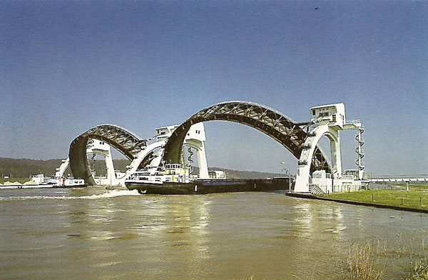
River boats of increasing size can often travel on the connecting canals, but many of the major locks have had to be reconstructed or replaced with new locks. One modern lockset has circular gates which rise rather than swing or retract.
A professor from Italy made a proposal for a future conference in Milan where there are canals from as far back as 1460, by De Vinci, which are being refurbished and improving some neglected areas of the city.
Comparison of Evolving Ship Measurements
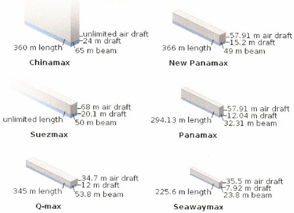
Tuesday evening we were guests of the Mayor at the Province House of Groningen for a reception and dinner. On Wednesday, there was a session on the increasing size of inland barges and the need to enlarge canals and locks, especially in Europe, Asia Minor and Russia, where the coastal ocean and inland sea traffic is so interlocked, as can be seen on the map above. The implications go far beyond, encompassing the whole world, as can be seen by the chart following of the limits on size of ships of the major canals of the world. The most interesting proposed new canal is across Turkey connecting the Black Sea with the Mediterranean and bypassing the Bosporus bottleneck. (See the circle & arrow on the map above.)
Another proposal is a 1300km long canal from the central lakes of Africa to South Africa. The double canal would run in both directions on each level, with the current flowing first in one direction and then in the other. Thus boats would flow with the 20 knot current up or down and need no power. As the water flowed from the lakes, south, it would fall through hydro-power stations to supply electricity and it would be fed by canals, to supply water for drinking and agriculture, up to 300 km on either side. It would have major implications to improve the social and economic conditions of millions of Africans. There are many problems to overcome not the least of which will be getting all the countries to cooperate.
In the afternoon we took off again in buses to tour the Province of Friesland to the west. Here the river widens into extremely large lakes. We visited an electric pumping station and were explained the details of controlling the water levels of the canal. Windmills were mainly used to pump and control the water levels as well as for grinding grains.
The lakes are being developed as major resorts and recreation boat destinations. To avoid pollution by fuels and personal waste, the whole system is being electrified with all yacht clubs, docking and fueling stations having metered battery recharging and pump-out facilities. Small diesel engines will be tolerated but basically all boating will have to have battery operated electric motors. The emphasis is on sailboats although we saw some fairly large and expensive yachts.
We had dinner during an evening cruise on the lake on a luxurious excursion boat. A novel feature was a whole buffet counter which had been prepared below deck and rose up from the center dance floor. Needless to say it was a very late hour when we returned to the hotel.
The last day the plans for the next conferences were presented.
In 2012, the conference will be in Yangzhou, China.
In 2013, the conference will be in Toulouse, France.
There is a proposal from the city of Milan, Italy, to host the conference in 2014.
The conference concluded with the adoption of the "Groningen Declaration" which supports the governance of the European waterways as shared heritage justifying the careful attention to the operation of all canals and waterways for both commercial and recreational uses.
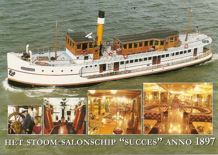
In the afternoon, we set out on a cruise from Groningen to Reitdeip on a large steam tug boat, the "Success" which had been gutted and completely restored into a luxury day cruise boat. It had a large salon for conferences and dinners and a topside bar and lounge. It is steam operated by using oil rather than coal for cleanliness and has a steam calliope for when going through towns or for water parades. It has a small diesel engine for maneuvering in a harbor or dock if the steam is not fired up. The trip was north on a new canal which had been built to provide a direct route for a widely wandering river. The trip took nine hours for what would have been a week on the river with an old barge. We had talks by the Provisional head of the National Water Board and after lunch by several commercial developers.
At nightfall, we disembarked and were treated to dinner in a old well preserved tavern, with costumed staff and traditional Dutch dinner. It was a fitting end to an informative and enjoyable adventure.
Towpath Topics is edited and published by Bill Gerber and Robert Winters.
Corrections, contributions, and ideas for future issues are always welcome.