
Middlesex Canal Association P.O. Box 333 Billerica, Massachusetts 01821
www.middlesexcanal.org
Middlesex Canal Association P.O. Box 333 Billerica, Massachusetts 01821
www.middlesexcanal.org
| Volume 64 No. 3 | June 2026 |
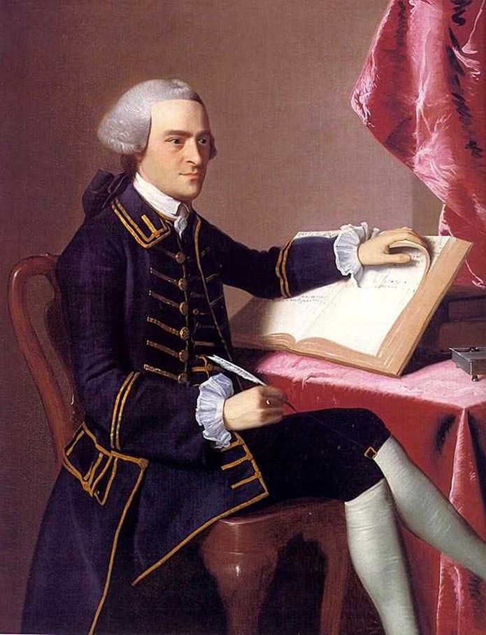
John Hancock was the first proprietor of the Middlesex Canal Corporation.
As Governor of the Commonwealth of Massachusetts, in 1793, he signed the legislation that incorporated the Middlesex Canal.
TABLE OF CONTENTS
MCA Sponsored Events / Directions to MCA Museum and Visitors’ Center
President’s Message: “Memorandum of Agreement” – by J. Breen
Middlesex Canal Commission – 2026 Annual Meeting Minutes
MCA Spring Walk, April 2026 – by Robert Winters
The Merrimack Flight of Locks and ‘The Wheel’ Revisited – by Bill Gerber
Editors’ Letter
Dear Readers,
Our apologies; that due to a scheduling mix-up, this issue did not come to you before the Spring MCA meeting. Sorry!
Tempers are high in North Billerica this spring as the fate of the Millpond Dam now rests in the hands of the State Supreme Court. Included in this issue are the minutes of the 2026 MCC Annual Meeting, for those of you who were unable to attend, and the discussions regarding the paths the MCC will try to take.
WGBH in March aired a 3-part episode on Henry David Thoreau. The first episode took the viewer down the Concord River to the millpond through various seasons. They also had older photos of the mills, the river, and the dam. The photography was beautiful and the perspective of the mills and the “new” museum building from inside. The river was an unusual vantage point. Of course, Thoreau hated the dam and would be happy if it was gone, but the episode did not mention the current fight to keep it!
The editors would like to turn your attention to the President’s Message which you can access on the MCA website. It is his “fantasy” memorandum of the dam issue and how he wants it settled.
Again, the editors are requesting submissions of any kind related to this Canal, any canal, or the people involved in canal life or work.
Happy Spring (and soon to be Summer),
The Editors
MCA Sponsored Events
24th Annual Bike Tour North, 9:00am, Saturday, October 3, 2026
Meet at the Middlesex Canal plaque right of the entrance to the Sullivan Square T Station, 1 Cambridge Street, Charlestown, MA 02129.
Leaders: Dick Bauer and Bill Kuttner
Fall Walk, 1:30pm, Sunday, October 18, 2026
Winchester – Medford
Meet at Shannon Beach parking lot, Mystic Valley Parkway
Fall Meeting, 1:00pm, Saturday, October 24, 2026
Speaker: TBA Location TBA
Medford Historical Society, 1:00pm, Saturday, October 31, 2026
Talk on Middlesex Canal by J. Breen
For more information on the fall meeting, bicycle rides and canal walks please access the MCA website, www.middlesexcanal.org.
The Visitors’ Center/ Museum is open Saturday and Sunday, Noon-4:00pm, except on a holiday.
The MCA Board of Directors meets the 1st Wednesday of each month at 3:30pm, except July and August.
Check the MCA website for updated information.
Directions to Museum: 71 Faulkner Street in North Billerica, MA
By Car
From Rte. 128/95
Take Route 3 (Northwest Expressway) toward Nashua, to Exit 78 (formerly Exit 28) “Treble Cove Road, North Billerica, Carlisle”. At the end of the ramp, turn left onto Treble Cove Road toward North Billerica. At about ¾ mile, bear left at the fork. After another ¼ mile, at the traffic light, cross straight over Route 3A (Boston Road). Go about ¼ mile to a 3-way fork; take the middle road (Talbot Avenue) which will put St. Andrew’s Church on your left. Go ¼ mile to a stop sign and bear right onto Old Elm Street. Go about ¼ mile to the bridge over the Concord River, where Old Elm Street becomes Faulkner Street; the Museum is on your left and you can park just beyond the bridge in the lot on your right. Watch out crossing the street!
From I-495
Take Exit 91 (formerly Exit 37) North Billerica, then south roughly 2 plus miles to the stop sign at Mt. Pleasant Street, turn right, then bear right at the Y, go 700’ and turn left into the parking lot. The Museum is across the street (Faulkner Street). To get to the Visitor Center/Museum enter through the center door of the Faulkner Mill and proceed to the end of the hall.
By Train
The Lowell Commuter line runs between Lowell and Boston’s North Station. From the station side of the tracks at North Billerica, the Museum is a 3-minute walk down Station Street and Faulkner Street on the right side.
President’s Message
“Memorandum of Agreement”
by J. Breen
The National Oceanic and Atmospheric Administration (NOAA), the lead federal agency, published March 18, 2026 its first draft of a Memorandum of Agreement (MOA) for the partial removal of the Talbot Mill Dam. NOAA’s proposed agreement is copied in part below where relevant to the president’s comments. The complete MOA is at the end.
MEMORANDUM OF AGREEMENT
AMONG THE NATIONAL MARINE FISHERIES SERVICE,
THE MASSACHUSETTS STATE HISTORIC PRESERVATION
OFFICER AND CRT DEVELOPMENT REALTY, LLC
REGARDING THE TALBOT MILLS DAM REMOVAL PROJECT
BILLERICA, MASSACHUSETTS HC-NMFS-XXXX-XXX-XXX
WHEREAS, the National Marine Fisheries Service (NMFS) is providing funds and technical assistance to support the Talbot Mills Dam Removal Project (the undertaking) in Billerica, Massachusetts, pursuant to the federal Magnuson-Stevens Fishery Conservation and Management Act; and
WHEREAS, the undertaking consists of the partial removal of the Talbot Mills Dam in Billerica, Massachusetts to eliminate a public safety hazard and restore riverine wetland habitat and a free-flowing riverine system for unimpeded migratory and resident fish passage; and
(1st comment) The dam was built by the Middlesex Canal Corporation to make a summit pond supplying water for the operation of the canal. Water not needed for the canal was by an 1825 agreement used by the Faulkner Mill. Rather than the later name of Talbot, the historic name used by Thoreau in A Week on the Concord and Merrimack Rivers, Billerica Falls, would be better as the government proposes to restore the historic falls.
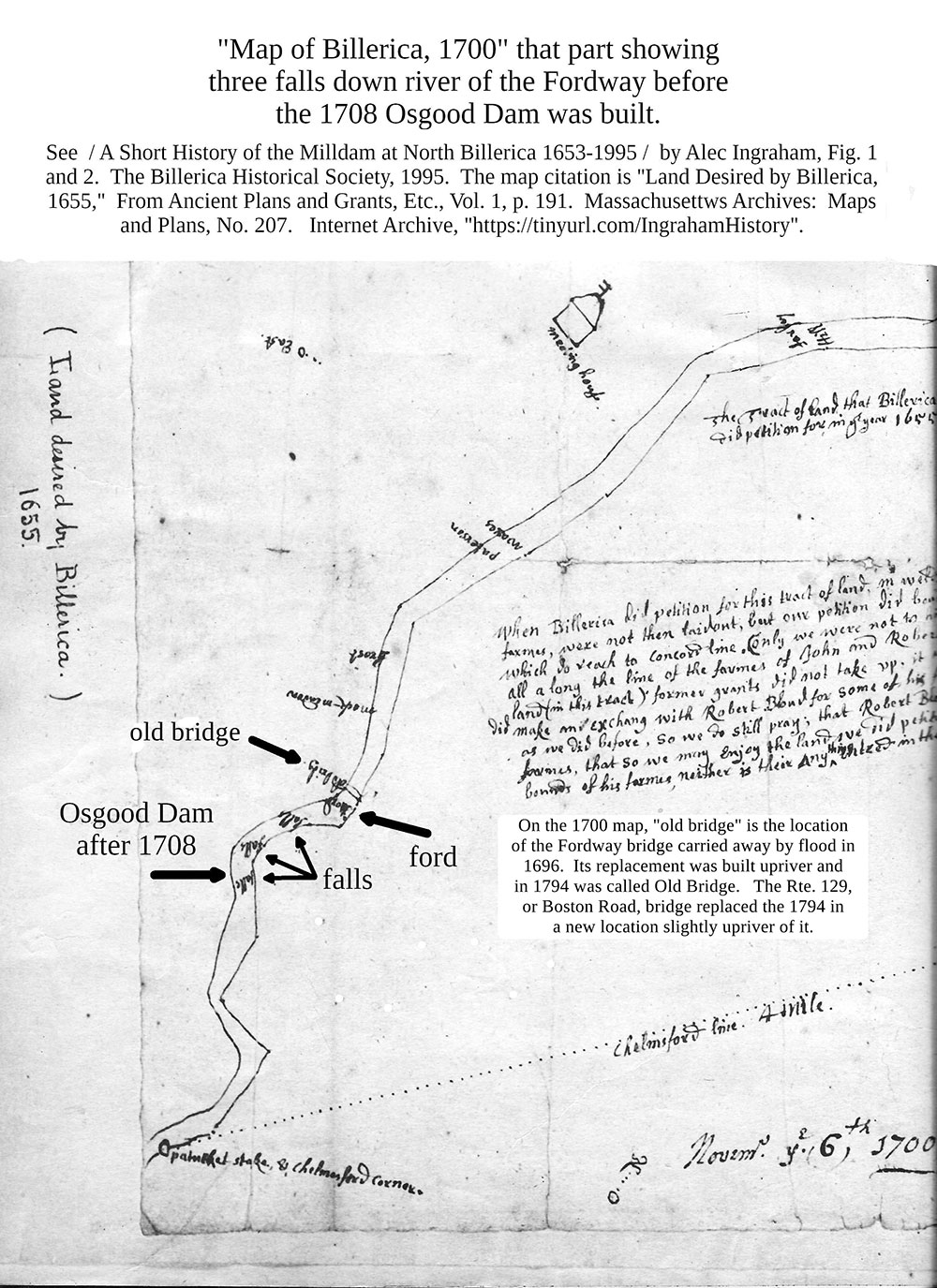
(2nd) “Unimpeded migratory”, No, a struggle. With the Billerica Falls Dam removed, the three falls and barrier of the Fordway recorded on the “Map of Billerica, 1700”, are restored. NOAA has not examined the effect on migration of the uncontrolled flow over three falls and the barrier as compared to the controlled flow and depth by a restored 1828 fishway and dam. Bathymetry of the Fordway barrier measures it as having an elevation of 107’± (NAVD88) for more than 500’ with a river width of 200’, a low flow, dry ford for walkers and a shallow killing field for predators. Copied below is a calculation indicating nearly three times more fish pass up the Concord with the aid of a renovated dam and fishway.
Part of the “Map of Billerica, 1700” is copied below.
IV. INTERPRETIVE SIGNAGE
The Project will fund the design, fabrication, and installation of two interpretive signs that describe and depict the historical significance of the Talbot Mills Dam and affected Middlesex Canal resources. The text and graphics will be developed by a 36 CFR 61- qualified architectural historian and/or archaeologist in collaboration with the Billerica Historical Commission and the Middlesex Canal Association to assist in developing the signage content. The text for the signs will summarize the important themes, trends, and events associated with the history of the dam and canal resources and will be illustrated with historical images, maps, and other graphics that will provide the public with an understanding of the historical significance of these structures.The text and graphics will be incorporated into sign panels at least 24”x36’ in size by a professional graphic designer. The final design for the signs will be reviewed and approved by the signatories before the signs are fabricated. The approved designs will be transferred to a sign fabricator who will reproduce the signs using a durable exterior-grade material with an appropriate mounting base. The signs will be erected at a place or places near the dam and/or the Middlesex Canal Association Museum to be selected in collaboration with the Billerica Historical Commission and the Middlesex Canal Association.
V. SALVAGE OF HISTORIC MATERIALS
CRT Development Reality. LLC will include a provision in the construction bid documents to salvage 5 granite capstones and 5 other blocks from the dam structure to the extent practicable. The salvaged materials will be available for use by the Middlesex Canal Association in future interpretive displays at the museum or by the dam owner at Faulkner Mills in Billerica.
(3rd) Part IV and Part V are what NOAA offers as mitigation for decontruction of the spillway of the Billerica Falls Dam, latterly known as the Talbot Mills Dam, and permanent draining of the summit pond. The Middlesex Canal Museum - Visitor Center is better at demonstrating the national historical significance of the canal than duplicative exhibits. A walking path around the former shore line of the pond with a bridge over the ancient river where the floating towpath crossed would be a substantive addition increasing the understanding of the floating towpath.
The regional bike path proposed between the Minuteman Bikeway at Bedford MA and the Merrimack River Bike Path at Lowell’s Rourke Bridge would cross the Concord on the bridge and use the Thoreau Towpath between the Concord and Merrimack Rivers. The proposed Concord bridge would be a mitigation for the lost high visibility of the dam and summit pond.
Calculation was submitted to the Billerica Conservation Commission at the public hearing October 28,2024.
1. The realty company which owns the dam has applied for permission to drain the summit pond and remove the dam. The applicant asserts an opinion that removing the dam will benefit migratory fish. Last year, 2023, 6,129 herring1 passed the Lawrence Dam, nowhere near the record 449,000. At the Centennial Dam fishway, 70% would have passed, or 4,290. The 70% is the top of the range for successful passage. The next obstacle to passage upriver is the Talbot, or Billerica Falls, Dam. A passage of 70% through a renovated 1828 fishway is 3,003. A high passage rate would be expected as the river flow through the fishway, Faulkner Canal, and low level outlets could be regulated solely to benefit the fish.
If the dam is removed, three ancient falls and the Fordway shown on the “Map of Billerica, 1700”, emerge as obstacles. With top efficiency of 70%, (0.7)4 x 4,290, or 1,030 fish, struggle and pass the Billerica Falls and Fordway. Nearly three times as many fish pass up the Concord with the aid of the dam. 3,003/1,030 = 2.9.
The lowered water level over the Fordway would be a feast for cormorants and gulls. A death zone for migrating fish.
2. The realty company also offers its opinion that recreation would be better after draining the summit pond. The Association offers its opinion that Zoar white water rafting in Lowell would be better year round with scheduled releases of water from the pond through renovated low water outlets in the dam than running the three falls with uncertain flows. Benefits with a renovated dam are draining the pond ahead of a flood and selling pond water to Centennial Hydropower during peak demand periods for electricity.
3. The realty company proposes to start destruction by removing 30’ of the dam, thus draining the summit pond. Why the realty company doesn’t use the existing two low water outlets, each approximately 3’x4’, is unknown.
Conclusion. The Association requests that the Conservation Commission require a peer review of the NOI which which would consider whether a renovated 1828 fishway would be better for the fish and Billerica. One possible peer is James Woidt, PE/Streamworks, PLLC, who in 2020 recommended that fish passage be verified, Review of Talbot Mills Dam Removal Feasibility Study. p. 16.
Note.
1. “River herring fishway counts at the project have decreased from 203,000 fish in 2021, to 50,535 fish in 2022, down to 6,129 this year”, a US Fish and Wildlife Service report released September 28, 2023, quoted in the October 23, 2023 Lawrence Eagle-Tribune, pp. 1 and 2, “Great Dam Relicensing Raises New Concerns” by Terry Date.
Following is the complete draft Memorandum of Agreement:
MEMORANDUM OF AGREEMENT AMONG
THE NATIONAL MARINE FISHERIES SERVICE,
THE MASSACHUSETTS STATE HISTORIC PRESERVATION
OFFICER AND CRT DEVELOPMENT REALTY, LLC
REGARDING THE TALBOT MILLS DAM REMOVAL PROJECT
BILLERICA, MASSACHUSETTS HC-NMFS-XXXX-XXX-XXX
WHEREAS, the National Marine Fisheries Service (NMFS) is providing funds and technical assistance to support the Talbot Mills Dam Removal Project (the undertaking) in Billerica, Massachusetts, pursuant to the federal Magnuson-Stevens Fishery Conservation and Management Act; and
WHEREAS, the undertaking consists of the partial removal of the Talbot Mills Dam in Billerica, Massachusetts to eliminate a public safety hazard and restore riverine wetland habitat and a free-flowing riverine system for unimpeded migratory and resident fish passage; and
WHEREAS, the NMFS has defined the undertaking’s Area of Potential Effects (APE) as being the limits of construction and upstream reaches of the impounded Concord River to the Pollard Street Bridge (limits of the disturbance) that will be affected by the undertaking, as depicted on the plan in Attachment A; and
WHEREAS, the NMFS has determined that the undertaking will have an adverse effect on the Billerica Mills Historic District and the Middlesex Canal Historic and Archaeological District, which are listed in the National Register of Historic Places (National Register), and has consulted with the Massachusetts State Historic Preservation Officer (MASHPO) pursuant to 36 CFR Part 800, the regulations implementing Section 106 of the National Historic Preservation Act (54 U.S.C. § 306108); and
WHEREAS, the NMFS has consulted with the dam owner CRT Development Realty, LLC, the applicant for Federal assistance and the party responsible for implementing the terms of this MOA, regarding the effects of the undertaking on historic properties, and has invited them to sign this MOA as an “invited signatory” pursuant to 36 CFR § 800.6(c)(2)(iii); and
WHEREAS, the NMFS has consulted with the United States Army Corps of Engineers (USACE), the United States Fish and Wildlife Service (USFWS), the Massachusetts Board of Underwater Archaeological Resources (MBUAR), the Middlesex Canal Commission (MCC), the Middlesex Canal Association (MCA), the Billerica Historic Commission (BHC), the Billerica Historic Districts Commission (the BHDC), the Massachusetts Commission on Indian Affairs (MCIA), the Mashpee Wampanoag Tribe, the Wampanoag Tribe of Gay Head (Aquinnah), and the Narragansett Indian Tribe regarding the effects of the undertaking on historic properties, and as a result of these consultations, has invited the USACE, the USFWS, the MBUAR, the MCC, the MCA, the BHC, the BHDC, the MCIA, and the Tribes to sign this MOA as “concurring parties” pursuant to 36 CFR § 800.6(c)(3); and
WHEREAS, in accordance with 36 CFR § 800.6(a)(1), the NMFS has notified the Advisory Council on Historic Preservation (ACHP) of its adverse effect determination with specified documentation, and the ACHP has chosen not to participate in the consultation pursuant to 36 CFR §800.6(a)(1)(iii); and
NOW THEREFORE, the NMFS, the MASHPO, and CRT Development Realty, LLC agree that the undertaking shall be implemented in accordance with the following stipulations in order to take into account the effect of the undertaking on historic properties.
STIPULATIONS
The NMFS will ensure that the following measures are carried out in consultation with the MASHPO:
I. MASSACHUSETTS STATE-LEVEL WRITTEN AND PHOTOGRAPHIC DOCUMENTATION
CRT Development Realty, LLC will engage a 36 CFR 61-qualified architectural historian to prepare Massachusetts state-level documentation of the Talbot Mills Dam, Billerica Canal Segment, Canal Segment 24, and the Floating Tow Path Peninsula, which are contributing properties to the Middlesex Canal Historic and Archaeological District and/or the Billerica Mills Historic District and will be affected by the undertaking. The documentation will be prepared in accordance with the Schedule of Documentation (SOD) contained in Attachment B, and will serve as a permanent archival record of the properties.
CRT Development Realty, LLC through the project contractor will coordinate with the architectural historian on the schedule for dewatering the impoundment above the dam, and prior to the demolition, to allow time and access for additional photographic documentation of the dam’s structure in dewatered conditions.
The Massachusetts state-level documentation package will be submitted to the BHDC for deposit in an appropriate local and publicly accessible repository. A copy of the letter transmitting the archival documentation to the BHDC shall be submitted to the MHC as notification of compliance with this MOA stipulation. The MHC will receive non-archival printed copy of the documentation with the letter transmittal.
II. SITE AVOIDANCE AND PROTECTION PLAN
A. The “Site Avoidance and Protection Plan” (SAPP) in Attachment C will be implemented to provide for the protection and avoidance of sensitive archaeological areas within the Billerica Mills Historic District and the Middlesex Canal Historic and Archaeological District. The sensitive areas consist of upland paved areas to be used for staging, loading, and access and upland park areas to either side and within the Faulkner Mill sluiceway (raceway) crossing to be used for the installation and removal of a temporary culvert, stone fill, and steel road plate throughout the dam removal work.
B. The NMFS will inform the ______ Tribe(s) at least fourteen (14) calendar days prior notice of the start of the construction, that construction work will commence, and that Tribal representatives will be afforded adequate notice and access to the Project site, to observe construction work in sensitive resource areas.
III. ARCHAEOLOGICAL MONITORING AND WALKOVER/RECONNAISSANCE SURVEY
A. CRT Development Realty, LLC will engage a 36 CFR 61-qualified archaeologist to conduct monitoring of the high-sensitivity area at the dam during removal activities to record internal components of the ca. 1828 dam and any potentially intact portions of a documented 1798 dam and/or earlier fishway structures. The monitoring would consist of documentation and recordation of exposed structural elements within the dam footprint(s) and below water levels at and buried in accumulated sediments just upstream of the dam(s). Archaeological walkover/reconnaissance survey of the high-sensitivity pond shoreline and permanently exposed impoundment and river channel drawdown areas will also be conducted to identify potentially significant pre- and post-contact resources that may be present including the recorded Middlesex Canal elements listed above.
The archaeological monitoring and walkover survey will follow a research design and field methodology approved under archaeological investigation permits issued by the Massachusetts State Archaeologist (950 CMR 70) and Massachusetts Board of Underwater Archaeological Resources (312 CMR 2). If potentially significant historic or archaeological resources are identified within the dewatered impoundment or upstream reaches of the river, then a plan to avoid or mitigate adverse effects to the significant resources will be developed in consultation with and implemented by the MOA signatoriesReporting – the archaeologist will prepare a technical report describing the results of the monitoring and post-dam removal walkover survey that meets the state permitting standards of the MASHPO guidelines for archaeological investigations (950 CMR 70.14). The draft report will be submitted to the MOA signatories for review, and approved by the NMFS, MASHPO, and MBUAR. The NMFS will consider all comments received from the MASHPO and MBUAR for incorporation into the final report. If comments are not received within 30 days of submission, the technical report will be considered complete and acceptable.
B. Reporting – the archaeologist will prepare a technical report describing the results of the monitoring and post-dam removal walkover survey that meets the state permitting standards of the MASHPO guidelines for archaeological investigations (950 CMR 70.14). The draft report will be submitted to the MOA signatories for review, and approved by the NMFS, MASHPO, and MBUAR. The NMFS will consider all comments received from the MASHPO and MBUAR for incorporation into the final report. If comments are not received within 30 days of submission, the technical report will be considered complete and acceptable.
C. The NMFS will ensure that two bound copies of the final technical report are provided to the MASHPO pursuant to 950 CMR 70.14 along with MASHPO archaeological inventory forms for identified archaeological sites, and an electronic file on a CD with the final report bibliographic entry and archaeological abstract. A digital copy of the final report will be provided to each of the MOA signatories. One bound paper and one digital copy of the final report will be provided to the BHDC as the permanent local repository.
IV. INTERPRETIVE SIGNAGE
The Project will fund the design, fabrication, and installation of two interpretive signs that describe and depict the historical significance of the Talbot Mills Dam and affected Middlesex Canal resources. The text and graphics will be developed by a 36 CFR 61- qualified architectural historian and/or archaeologist in collaboration with the Billerica Historical Commission and the Middlesex Canal Association to assist in developing the signage content. The text for the signs will summarize the important themes, trends, and events associated with the history of the dam and canal resources and will be illustrated with historical images, maps, and other graphics that will provide the public with an understanding of the historical significance of these structures.
The text and graphics will be incorporated into sign panels at least 24”x36’ in size by a professional graphic designer. The final design for the signs will be reviewed and approved by the signatories before the signs are fabricated. The approved designs will be transferred to a sign fabricator who will reproduce the signs using a durable exterior-grade material with an appropriate mounting base. The signs will be erected at a place or places near the dam and/or the Middlesex Canal Association Museum to be selected in collaboration with the Billerica Historical Commission and the Middlesex Canal Association.
V. SALVAGE OF HISTORIC MATERIALS
CRT Development Reality. LLC will include a provision in the construction bid documents to salvage 5 granite capstones and 5 other blocks from the dam structure to the extent practicable. The salvaged materials will be available for use by the Middlesex Canal Association in future interpretive displays at the museum or by the dam owner at Faulkner Mills in Billerica.
VI. DURATION
This MOA will expire if its terms are not carried out within five (5) years from the date of its execution. Prior to such time, the NMFS may consult with the other signatories to reconsider the terms of the MOA and amend it in accordance with Stipulation X below.
VI. POST-REVIEW DISCOVERIES
If an unanticipated discovery of a potentially significant historic property or human remains is made during construction of the project, NMFS shall implement the procedure identified in Stipulation 8 of the ASAPP in Attachment C.
VIII. DISPUTE RESOLUTION
A. Should any signatory to this MOA object within thirty (30) calendar days to any actions proposed or carried out pursuant to this MOA, the NMFS shall consult with the signatory to resolve the objection. If the NMFS determines that the objection cannot be resolved, the NMFS shall forward all documentation relevant to the dispute to the ACHP. Within thirty (30) calendar days after receipt of all pertinent documentation, the ACHP will either:
1. Provide the NMFS with recommendations that the NMFS will consider in reaching a final decision regarding the dispute; or
2. Notify the NMFS that it will comment pursuant to 36 CFR 800.6(b), and proceed to comment. Any recommendations or comments provided by the ACHP will be understood to pertain only to the subject of the dispute: the NMFS’s responsibility to carry out all actions under the MOA that are not subject of the dispute will remain unchanged.
B. If, at any time during the implementation of the measures stipulated in this MOA, an objection should be raised by an interested member of the public or consulting parties, the NMFS will consult with the other parties to this MOA to determine the appropriate response.
IX. LIMITATIONS AND ASSURANCES
This MOA is not a fiscal or fund obligating document, and no funds are to be transferred, hereunder. The NMFS will ensure that CRT Development Realty, LLC gain bestprofessional estimates for all activities proposed in this undertaking. The NMFS agrees to not proceed with the undertaking until CRT Development Realty, LLC and Project partners have obtained adequate funding, based on best professional estimates, to fulfill obligations under this MOA.
X. AMENDMENTS
This MOA may be amended when such an amendment is agreed to in writing by all signatories. The amendment will be effective on the date a copy signed by all of the signatories is filed with the ACHP.
XI. TERMINATION
If any signatory to this MOA determines that its terms will not or cannot be carried out, that party shall immediately consult with the other parties to attempt to develop an amendment per Stipulation VIII above. If, within thirty (30) calendar days (or another time period agreed to by all signatories), an amendment cannot be reached, any signatory may terminate the MOA upon written notification to the other signatories.
In the event the MOA is terminated by a signatory pursuant to XI A above, the NMFS will either execute a MOA with signatories pursuant to 36 CFR 800.6 (c) or request the comments of the ACHP under 36 CFR 800.7 (a).
The execution of this MOA and its subsequent filing with the ACHP evidences that the NMFS has taken into account the effects of the undertaking on historic properties and has afforded the ACHP an opportunity to comment on the undertaking.
SIGNATORY PAGE
MEMORANDUM OF AGREEMENT AMONG
THE NATIONAL MARINE FISHERIES SERVICE,
THE MASSACHUSETTS STATE HISTORIC PRESERVATION OFFICER
AND CRT DEVELOPMENT REALTY, LLC
REGARDING THE TALBOT MILLS DAM REMOVAL PROJECT
BILLERICA, MASSACHUSETTS
HC-NMFS-XXXX-XXX-XXX
Signatories:
_______, Director, Office of Habitat Conservation, National Marine Fisheries Service
Brona Simon, Executive Director, State Historic Preservation Officer, State Archaeologist, Massachusetts Historical Commission
Robert Martin, CRT Development Realty, LLC
Concurring Parties:
_______, U.S. Army Corps of Engineers
_______, Assistant Regional Director - Ecological Services, U.S. Fish and Wildlife Service
David S. Robinson, Director, Massachusetts Board of Underwater Archaeological Resources
_______, Middlesex Canal Commission
_______, Middlesex Canal Association
_______, Billerica Historic Commission (BHC)
_______, Billerica Historic Districts Commission
Attachments:
A – APE Map
B – Schedule of Documentation for Historic Resources
C – Site Avoidance and Protection Plan (SAPP)
2026 Annual Meeting – Minutes
Attending: Mike Mcinnis (Chair); Thomas Lincoln (Secretary); Doug Chandler (Chelmsford); Peter Engeldrum (Winchester); Debra Fox (Billerica); Shayne Reardon (Billerica); Dick Bauer (Somerville); Kelly Lynema (NMCOG); Victoria Juner (Lowell); Jeffrey Harris (DCR); Peter Sutton (MASSDOT); Rep. David Robertson (House of Rep.); - Guests: J. Breen; (Pres., MCA); Bill Kuttner (Boston); Andrew Jennings (Billerica); Bill Swanton (Winchester); Amanuel Regassa (NMCOG); Dan Valentine (BHDC); Steven Parker; Marlies Henderson (N. Billerica); Bill Swanton (Winchester); Don LeBlanc (Dracut); Joe Jackson (Wilmington)
MCC Chair Intro: Mr. Mcinnis (Chair) called the Meeting to order at 3:17pm, welcomed attendees and thanked Betty Bigwood for providing the excellent pastries. He then briefly reviewed the Agenda.
Secretary’s Report – the Minutes of the 2025 Annual Meeting were read and approved.
Treasurer’s Report – Balance is $2,441.13, per Betty Bigwood, as reported by the Chair. The Treasurer’s Report was approved.
GLBPP Update – Doug Chandler (Chelmsford) gave an excellent update on the GLBPP (Greater Lowell Bicycle and Pedestrian Plan), which is under the general aegis of NMCOG. In addition to his work with the FORTT group (Messrs. Jennings, Breen and Kuttner, and Ms. Henderson), Mr. Chandler is also a member of the Advisory Committee to the GLBPP. The overall goal of the GLBPP is to improve bicycle and pedestrian amenities in Lowell and neighboring communities. In general, the goal is to have a continuous path from the Summit Pond/ Talbot Mills Dam to the Merrimac River in Lowell. Mr. Chandler emphasized some portions of the path are already extant, but remain unconnected. In addition, there are several stretches where achieving continuity will be more difficult. He also noted these areas of progress: completion of the connector trail to Plain St. by the Lowell Parks and Conservation Trust; funding to finish the Yankee Doodle Trail in Billerica; construction of the Rourke Bridge in Lowell. In addition, several connected pieces will benefit from easements, including the very real possibility of an easement from the owners of ProAV for the East Chelmsford Connector. NMCOG is soliciting public input on the GLBPP, as the initial Plan is about to be released. Since much of the proposed infrastructure incorporates, parallels, or otherwise involves the Middlesex Canal, Mr. Chandler again requested a letter of support from the MCC. The following motion was proposed, seconded and passed unanimously:
“Whereas the Middlesex Canal Commission (MCC, the Middlesex Canal Association (MCA) and the Friends of Regional Towpaths and Trails (FORTT) have been working to make towpaths into multi-use trails and bridge gaps in existing trail networks; and
Whereas NMCOG is now completing the GLBPP (Greater Lowell Bicycle and Pedestrian Plan); and
Whereas the MCC voted in March, 2025 to support the GLBPP and offer its easements accordingly; and
Whereas the Chelmsford Bicycle and Pedestrian Advisory Committee (BAPC) is working on the East Chelmsford Connector; and
Whereas the new Rourke Bridge is nearing completion, but remains disconnected to the Bruce Freeman Rail Trail (BFRT) or Yankee Doodle Trail;
Therefore the MCC votes to:
Send a support letter of support of the GLBPP to Mr. Regassa at NMCOG that also urges NMCOG to prioritize off-road multi-use trails using Canal towpaths, particularly for these segments: ECC, Crosspoint to Rourke Bridge, and Yankee Doodle to the Talbot Mills Dam.”
Mr. Lincoln will send a letter accordingly to Mr. Regassa at NMCOG. It was also agreed to post Mr. Chandler’s presentation on the Website of the Middlesex Canal Association – www.middlesexcanal.org
Update on the Talbot Mills Dam Removal Proposal
The Chair introduced this item by noting that this remains the critical issue facing the Middlesex Canal and the Middlesex Canal Commission. He and Mr. Lincoln provided a brief update concerning the matter, particularly developments at the Billerica Historic Districts Commission (BHDC) and Billerica Conservation Commission. In brief: the BHDC voted to deny the dam owner permission to remove the Dam (December, 2025). The proponent (CRT Realty, LLC) appealed to NMCOG. NMCOG required BHDC to provide specific reasons for the denial, which BHDC did in February, 2026. At the request of CRT Realty, LLC, NMCOG also asked BHDC as to their interest in using mediation in the matter.
BHDC declined the idea at their meeting on March 4, 2026. Kelly Lynema of NMCOG noted that NMCOG has no further role to play in the BHDC/CRT matter. Ms. Henderson noted that CRT Realty LCC has now filed a lawsuit in Superior Court to overturn the BHDC decision.
The Chair noted that it appears the Dam dispute is at an impasse and suggested that the MCC should make an effort to ensure the continuing existence of the Talbot Mills Dam. Accordingly, he proposed the following motion:
Motion to authorize the Executive Committee and such person or persons as they deem useful, to ascertain the interest of CRT Realty, LLC in conveying ownership of the Talbot Mills Dam to the Middlesex Canal Commission on a mutually acceptable basis. The goal shall be to report back to the full Commission in due course, for further action, as necessary and appropriate.”
The Motion was seconded and the floor opened for discussion, Mr. Valentine was asked to comment on the actions of the BHDC. Mr. Jennings suggested that the Motion be broadened to contemplate conveyancing the Dam to other possible parties, such as the DCR or the Town of Billerica. Mr. Lincoln said the MCC can only take actions within its purview and that we have no jurisdiction or powers concerning the DCR or other such parties. Mr. Jennings withdrew his suggestion. The topic of Section 106 mitigation was then raised, but several members noted its irrelevance to the Motion, not least because Section 106 only applies when a federal action has been completed, i.e., the removal of the Dam. Mr. Lincoln noted that this has not happened. A question was then asked by Ms. Fox about the power of the Superior Court, noting that no preservation statute has been over-turned in the past 60 years. Mr. Breen noted that it is his understanding that the Superior Court has “equity” powers and can order a financial remedy without ruling on the legitimacy of the underlying ordinance or statute.
The Chair solicited additional discussion. Hearing none, he moved the Motion to a vote. The Motion passed 8-0.
Section Activities Reports
Lowell – See above discussion concerning the GLBPP. Victoria Juner is the new Lowell representative.
Chelmsford – Mr. Chandler updated the MCC concerning the GLBPP and related aspects of trails/Canal coordination, as part of the regular Agenda.
Billerica – See attached Appendix 1. Mr. Lincoln complimented the Section on their work.
Wilmington – The Chair noted the pedestrian bridge at the Maple Meadow Brook Aqueduct (Middlesex Canal Town Park). The estimated cost is approximately $600,000; funding is still undetermined.
Woburn – no report
Winchester – Mr. Engeldrum noted that he and Mr. Swanton are working on a film about the Canal and Winchester. He had previously consulted with Mr. Lincoln about the Brooks family and the Canal.
Medford – Mr. Lincoln confirmed that there has been no Canal activity in Medford.
Somerville – Mr. Bauer announced the Annual Middlesex Canal Bike Ride to be held March 29, 2026, in its usual “North and South” configuration. Details are available at www.middlesexcanal.org
Charlestown – Mr. Kuttner of Charlestown raised the continuing issue of securing an appointment by the City of Boston as its representative to the MCC. This has proven to be a non-starter.
Current Status of the New Middlesex Canal Museum (2 Old Elm St., North Billerica)
President Jay Breen of the MCA gave a brief update on this very exciting project. Great progress has been made thanks to the endless and strenuous efforts of the MCA Building Committee; only a few tasks remain before an Occupancy Permit can be granted. These include: fitting of the custom range hood in the Museum kitchen; and paving for Old Elm Street in front of the Museum site. Given the general complexity of the project, Mr. Breen said an end-of-2026 deadline seemed logical.
New Business
No new business.
Election of Officers
The Chair confirmed that he is not standing for re-election. The Chair then conducted the election. A call for nominations was made; the following nominations were made, in this sequence:
Joe Jackson of Wilmington as Assistant Treasurer. Seconded. Approved 8-0, contingent upon his securing City/Town appointment;
Betty Bigwood (incumbent) of Wilmington as Treasurer. Seconded. Approved 8-0;
Thomas Lincoln (incumbent) of Medford as Secretary. Seconded. Approved 8-0;
Andrew Jennings as Chair. Seconded. Approved 8-0, contingent upon his securing City/Town appointment.
Adjournment: A motion to adjourn was made and passed at 5:05pm.
These Minutes respectfully submitted by
Thomas W. Lincoln, Secretary
Appendix 1 – Billerica Section report – March 19, 2026
Middlesex Canal Commission
Billerica Section
Annual Report: July 2024 to December 2025
Members: Alec Ingraham, Debra Fox, Richard Hawes, Shayne Reardon
Note: Meetings are held at the Middlesex Canal Museum and Visitors’ Center at 71 Faulkner Street, North Billerica, MA.
Meetings Held: July 10, 2024; September 11, 2024; November 13, 2024; January 15, 2025; March 12, 2025; May 14, 2025; July 9, 2025; September 10, 2025; and November 17, 2025
Highlights:
1. Members voted to change the meeting times from 7:00pm to 3:00pm, remaining on the second Wednesday of alternate months.
2. Dick Hawes was voted to be the “member” representative from the Billerica Section to the Middlesex Canal Commission. Alternates may vote when he is unavailable.
3. Members were updated throughout the year by Andrew Jennings on the progress of the rail trails (FORTT Committee).
4. Members were updated by Dick Hawes on the progress of the construction for the new canal museum at 2 Old Elm Street.
5. Talbot Mills Dam – Proposals were made to remove the dam through public hearings with the BHDC. The outcome is still pending.
6. Canal Signs, plantings on Lowell Street, and maintenance of the High Street marker site were continued to be monitored by the Billerica Section members.
Respectfully submitted,
Debra Fox
Secretary - MCC: Billerica Section
MCA Spring Walk, April 2026
by Robert Winters
We were originally scheduled to do the Spring Walk on March 22, but threatening weather forced the walk to be postponed to April 12. Better weather and more advanced notice with the Boston Area Walking Meetup Group yielded a good crowd of between 40 and 45 participants. We met at the Crowne Plaza Hotel parking lot on Middlsex Canal Drive right next to a water-filled section of the canal. Walk Leader Robert Winters was ably assisted by MCA President J. Breen as MCA Board member and videographer Roger Hagopian.
For the southward section of the walk, we went all the way to Abbott’s Landing where there are historical plaques commemorating that location during the operation of the Middlesex Canal. We also saw plenty of survey markers associated with active plans to create a linear path along this route where a rail line ran parallel to the canal. This is an exciting oportunity to highlight our historic canal as many more people may soon be traveling along this right-or-way right next to the canal.
The second leg of the walk (for the half dozen or so who persevered) followed the canal from the relocated Baldwin Mansion (now the Szechuan Garden Restaurant) north to School St. in Woburn.
A good time was had by all.

THE MERRIMACK FLIGHT OF LOCKS
And ‘The Wheel’ Revisited
by Bill Gerber
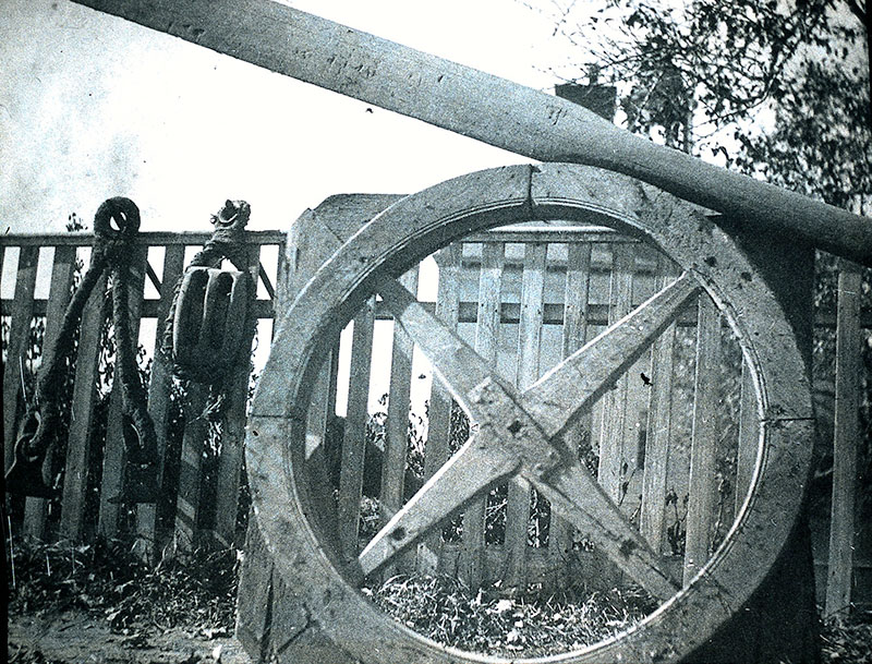 Figure 1. Misidentified Wheel From the Leon Cutler - Moses Whitcher Mann Collection |
In the February 2022 issue of Towpath Topics I wrote to correct the misunderstanding of a wheel that was photographed (by either Leon Cutler or Moses Whitcher Mann; I’m not sure which to credit.), shown in Figure 1, sometime in the 1930s1. At the time the picture was taken, the photographer suggested that the wheel might have been a paddlewheel from a towboat that had operated on the Middlesex Canal.
When I wrote of such towboats2, I cautiously accepted that the wheel might have been from John Langdon Sullivan’s 1816 towboat, which, I learned later, was used to tow a Packet on the Merrimack River; likely transporting passengers and light freight between Middlesex Village in Chelmsford MA and Nashua NH, and perhaps as far up the Merrimack as Litchfield NH.3
But not long ago (circa 2020), when a Chelmsford historian cleaned out his garage, he found the actual wheel along with a bill of sale. It was then that we learned that the wheel had an entirely different purpose not related to any of Mr. Sullivan’s towboats. It was, instead, part of the mechanism that controlled the flow of water into and out of a lock of the Merrimack Flight of locks. And we learned that the ‘ears’ on the wheel were just crude means to reinforce badly worn and weathered wooden joints.
More specifically, the wheel would have been attached to the axle of a ‘pinion gear’ that, when turned, would move a ‘rack gear’ up or down, which in turn would raise or lower a paddle at the end of an attached long rod, to open or close a water channel. Simple as that. An example of the entire mechanism is shown in Figure 2, courtesy of British canal historian, Mike Clarke.4
This is a very familiar mechanism, still used at the locks on many canals in England; though any wheels have largely been replaced with removable crank handles, issued only to boatmen, to reduce nuisance and harassment actuations.
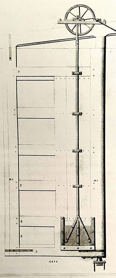 Figure 2. Paddle actuation mechanism, canal lock water control device |
We know that the original pattern for the rack and pinion gear set was given to Loammi Baldwin by British canal engineer William Weston who mentored Baldwin during the early stages of construction of the Middlesex Canal.5 Initially, Baldwin had a metal working firm in NY fabricate his initial sets of gears, he would have needed many more before project completion.
On the Middlesex Canal, the mechanism would have been used in two capacities. Following construction of the Merrimack Flight, which was constructed of granite, most of the locks on the Middlesex were built of wood. (This traded cheap construction for greater long term maintenance costs.) In the wooden locks the paddle gates were probably built right into the lock gates themselves, as shown in Figure 2; thus, speculatively, there was likely one paddle-gate assembly for each of the two upper mitre-gates, and one for each of the two lower mitre-gates for each lock, i.e., a total of four per lock.
But the use of the mechanisms at the Merrimack Flight may have been slightly different. As noted, this three-lock ‘staircase’ was built of stone, i.e., granite with hydraulic cement, and it was built with bypass channels, culverts, as Baldwin calls them, to enable water to flow around the miter-gates, rather than though them. As such, the paddle-gates would have controlled the flow of water into each culvert. It seems reasonable to expect that there might have been two of these culverts providing inlet water into each of the three locks of the staircase, plus two outlets from the bottom lock to river level, a total of eight for the entire flight.
How do we know this? There are three sources that come readily to mind. First, during the construction phase there was an exchange of letters between Middlesex Canal Engineer Loammi Baldwin and English Canal Engineer William Weston about the culverts6; Baldwin wanted to build one culvert per lock, Weston persuaded him to build two.
In a letter to Weston in March, 1797, Baldwin stated: “I wish to ask if one culvert will not answer & whether the wing wall may not be reduced from what is expressed in your plan”.
In May of that year, Weston responded: “I shall answer your several queries in this respective order - Culverts. You wish to be informed whether one of the circular culverts intended to convey the water from the upper to the lower level may not be dispensed with. __
I do not think it would be prudent to depend wholly upon one as however careful you may be in the construction accidents may occur and you would then have no remedy but to stop the trade on the Canal until it was repaired an object of infinitely greater consequence than the additional expense of making another culvert in the first instance”
Second, we have testimony from Judge Samuel Hadley who, as a boy, grew up in Middlesex Village. His father was the lock keeper there, though business manager for the canal’s interests may be a better description. In his memoirs7, Judge Hadley observed:
“When the canal was drawn off, it was a common thing for the boys to crawl down the paddle culvert of an upper lock, and make their way down along the brick subterranean conduit which ended near the bottom of the lock below, this being the way in which the water was carried from an upper to a lower lock. There were two of these culverts to each lock. I can recall the shivery gloom of this passage, the watery odor which pervaded these water-worn stone and brick culverts, through which we used to crawl.”
And a third source also comes from the Leon Cutler - Moses Whitcher Mann glass slide collection. In it there are two long-overlooked photos of drawings of the Merrimack Flight done by “S.G. Stephens”, though we don’t know exactly when.
Alec Ingraham, co-editor of Towpath Topics (newsletter of the Middlesex Canal Association), turned up the following:
The drawings are probably by Samuel G. Stephens, born in Lowell in 1855 and died in Chelmsford in 1943. He was the son of Alexander and Elizabeth Stephens who it appears emigrated from England. His obituary in the LOWELL SUN included the following:
When he passed away he was just shy of his 88th Birthday. He was an instructor of mechanical drawing at MIT for 7 years. From the directories this would be roughly between 1885 and 1895. He was an instructor of drawing at the evening school in Lowell for 42 years and for 30 of the years principal drawing school. He was also employed as a mechanical engineer for the Appleton and Hamilton Mill of Lowell and later as a draftsman for the B&M RR. In 1893 he is listed as a draftsman in the Boston Directory at 73 Tremont Street; also later entries as well. In Lowell Directories, after 1900, he is listed in some as draftsman on his own account and also as a machine designer. In 1930, he and his wife were living with their daughter on Baldwin Street in Lowell. Samuel was employed as a draftsman for the B&M RR. He was 74 years old.
At this point we need to assume that Stephens was a competent observer, that he was early enough to see the Merrimack Flight before it was ‘quarried’ (for who knows what purposes), destroyed and covered over, and that his drawings are reasonable representations of what he saw. As a draftsman and drafting teacher who was probably at the peak of his profession between 1885 and 1895, that seems like a reasonable assumption. That late in his life he lived on Baldwin Street would have placed him very close to the ruins of the Merrimack Flight.
That said, the configuration of the flight of locks is somewhat different than anticipated. In Figure 3, Stephens shows culverts (the dashed lines) extending from the upper lock to the middle lock, and from the middle lock to the lower lock. He does not show culverts around the top gates of the top lock, nor the bottom gates of the bottom lock. And so the water control configuration at the Merrimack Flight appears to have been something of a hybrid arrangement, with water control paddles probably built into each of the two top mitre-gates of the upper lock, and the two bottom mitre-gates of the bottom lock. In between, there would have been paddles to control the inlets to each of the culverts, one on each side of the top and middle locks.
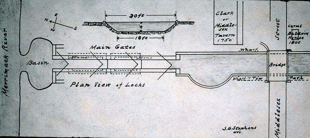
Figure 3. Top View of Merrimack Flight of Locks showing ‘culverts’ from top to middle and middle to lower locks.
Drawing by Samuel G. Stephens. Photo from the Leon Cutler - Moses Whitcher Mann Collection
Stephen’s second drawing, Figure 4, also holds a surprise. Note that the upper gates for each of the locks reach to the bottom floor of their respective lock. Where the paddle was built into the gate, when it was opened, this approach kept water flow very low with respect to the vessel within the lock. Later lock construction practice would place shorter gates, i.e., only as tall as the depth of the upper level, on the breast-wall at the upper end of the lock. But then if the paddle was built into the gate, this would introduce a stream water into the lock from a higher level and, if not carefully introduced or diverted, could run the risk of flooding a vessel and possibly sinking it within the lock.
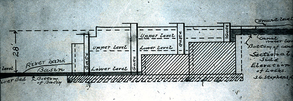
Figure 4. Side View of Merrimack Flight of Locks showing ‘the placement of the upper gates in each of the locks of the three-lock staircase.
Drawing by Samuel G. Stephens. Photo from the Leon Cutler & Moses Whitcher Mann Collection
From the same memoirs as cited earlier8, Judge Hadley gives us a description of the difficulty of operating the Merrimack Flight. He states:
“As soon as I became strong enough to handle the heavy gates, say about the age of fourteen, I was employed every spring and summer for some years in tending the locks, and doing the usual clerical work incidental thereto. In addition to the usual lockage of boats, bands of lumber logs, ship timber for the hulls of vessels constructed at Medford and East Boston, spars and masts from the forests of the upper Merrimack to the number of 40 or 50 “shots” each, a “shot” representing in its passage through the locks a boat, were common enough, and beginning at 5 o’clock in the morning with an interval for meals, I have many a time seen the last “shot” enter the canal when it was too dark to make out a pass-port without artificial light. Of course this did not occur every day, but often every week. Strung together this long line of “shots,” extending from the locks down the canal sometimes quite a distance below the sluice-way east of Stedman Street, would be taken in tow by Col. Bowers or his sons Alpheus or Sewall, with their two yokes of fine oxen, and a horse leader, and slowly but surely delivered in Medford or Charlestown.”
“It may not be uninteresting to consider for a few moments the method of passing boats and “shots” through the locks, a matter which I have never seen presented by anyone who has undertaken to write about the old canal. It will be demonstrated before I am through with it, that this was a sort of service which called for experience and careful attention to a number of details which do not readily occur to one familiar only with the theory.”
“The difference of level between the surface of the water in the canal, and that of the Merrimack at ordinary stages of the water, was about twenty-five feet. There were three locks about 80 feet in length, with of course four sets of gates, called balance-lever gates. At the head of each lock there were what were called paddle-gates, that is, gates placed at the portal of a stone culvert, on each side of the lock, which paddle gates swung upon centres. When opened, the water was allowed to pass by brick culverts, around the heels of the main gates, into the locks below. Bear in mind that this is the water of the Concord, and not of the Merrimack. Not a drop of the Merrimack ever entered by the locks into the Middlesex Canal.”
“In addition to these side culvert water-ways, there were three paddle-gates inserted in the main gates for a similar purpose, one in the west upper lock south gate, and two in the lower lock gates. These lower lock gates were made necessary from the fact that as the lock immediately connected with the Merrimack it was obviously impossible to use the side culverts.”
“We will now lock up a boat from the Merrimack to the canal. The loaded boat appears at the entrance of the lower lock. The tender’s first act is to fill the upper lock level with the canal. He then opens the two main gate paddle-gates, of the lower lock, which when opened, draw down the water of the lower lock to the level of the Merrimack. This done, he throws open the main gates one at a time, after opening one he crosses to the other side and opens the other main gate. The loaded boat then entered the lower lock, and after it is in the lower main gates are closed. The tender then goes to the lower paddle-gates of the second lock, which from leakage is partly filled, and opens them to fill the lower lock, in which the boat now floats, taking care to do so very gradually, for the reason that if the boat is heavily loaded, and has little free-board, too much water may sink it.”
“The boat begins to rise, in the lower lock — and the water to lower in the second lock. If the tender found he had so much leakage in the second lock as to more than fill the lower one, he avoided an overflow, by opening for a few moments one of the lower paddlegates, until the lower lock was evenly filled. When the lower lock was evenly filled, there was water enough to permit the passage of the boat into the second lock. The lower gates of the second lock were then opened, and the boat was passed into the second lock, and the main gates closed behind it. The tender then went to the paddlegates of the upper lock, and at this point he was called upon to exercise the greatest care in filling his lock. He was to see to it that the water of the upper lock was sufficient to fill his second lock, and if he was in doubt he had to run to one of the main gate paddles, and let in enough water from the canal to make up for any threatened shortage. Meanwhile the loaded boat is slowly rising. When the water and the boat reached the level of the second lock, the lower gates of the upper lock were thrown open and the boat passed into the upper lock.”
“Care had to be taken with a heavily loaded boat, and the water was not allowed to fall by leakage, for if the boat took ground on the bottom or miter-sill of the upper lock, it might sink in a moment, or perhaps break in two. To avoid this possible event, the tender went forward to the upper gates or canal gates of the upper lock and allowed water enough to run into the lock from the canal to make up for any leakage in the main gates of the second lock.”
“The boat having now entered the upper lock, the main gates are closed, and the upper lock is also carefully filled to a level with the canal, by opening its paddle-gates. When the lock was filled the main gates were opened and the boat was passed into the canal, not however until the collector had examined the cargo, compared it with the bill of lading, and given the skipper a passport through the canal, with the name of the owner, captain and description of cargo. Of course all these particulars were entered in a book kept for the purpose.”
“You will notice that in the description I have given of locking up a boat, the great thing to know about and that was acquired only by experience, was allowances for leakage. I have had many an old boatman tell me when I was a boy, that they would not dare to lock themselves through. There was too much to think about in the operation.”
And so we now know that ‘the wheel’ had nothing to do with propelling Mr. Sullivan’s 1816 steam towboat. It clearly was once a part of a water flow control mechanism at the Merrimack Flight of locks; and a busy and fairly complex set of locks to operate they were.
Footnotes:
1 Gerber, Bill: The Wheel; http://www.middlesexcanal.org/towpath/towpathtopicsFeb2022.htm
2 Gerber, William; John Langdon Sullivan: The Development and Use of His Steam Towboats, http://middlesexcanal.org/towpath/towpathtopicsFeb2010.htm
3 Gerber, Bill: A Packet on the Merrimack, http://middlesexcanal.org/towpath/towpathtopicsSept2012.htm; and The 1816 Tow Boat, http://middlesexcanal.org/towpath/towpathtopicsApr2014.htm#towboat
4 Clarke, Mike: ‘Naming of the Parts’, World Wide Waterways magazine issue #37, May 2022, pp 16, 17; original drawing from - Strickland, Gill and Campbell; Public Works in the USA, first published in 1841.
5 Baldwin, James F.; Minutes of the History of the Middlesex Canal, Letter - W. Weston to L. Baldwin, date 31 May 1797; Winterthur Library, Joseph Downs Collection #204
6 Baldwin, James F.; Minutes of the History of the Middlesex Canal, Letter - L Baldwin to W Weston dated March 13 1797 and Letter - W. Weston to L. Baldwin, date 31 May 1797; Winterthur Library, Joseph Downs Collection #204
7 Contributions of the Old Residents’ Historical Association - Boyhood Reminiscences of Middlesex Village. By Hon. Samuel P. Hadley. Read in Three Parts, February 8, 1905, May 10, 1905, and February 9, 1910, P-233
8 Contributions of the Old Residents’ Historical Association - Boyhood Reminiscences of Middlesex Village. By Hon. Samuel P. Hadley. Read in Three Parts, February 8, 1905, May 10, 1905, and February 9, 19 10. PP-234-237
The long-abandoned tollhouse at the top of the Merrimack Flight of locks
MISCELLANY
Back Issues – The first issue of the Middlesex Canal Association newsletter was published in October, 1963. Originally named “Canal News”, the first issue featured a contest to name the newsletter. A year later, the newsletter was renamed “Towpath Topics.” More than 60 years of back issues of Towpath Topics, together with an index to the content of all issues, are also available from our website http://middlesexcanal.org/towpath and http://middlesexcanal.org/towpath/towpathindex.htm. These are an excellent resource for anyone who wishes to learn more about the canal and should be particularly useful for historic researchers.
Estate Planning – To those of you who are making your final arrangements, please remember the Middlesex Canal Association. Your help is vital to our future. Thank you for considering us.
Membership and Dues – There are two categories of membership: Proprietor (voting) and Member (non-voting). Annual dues for “Proprietor” are $25 and for “Member” just $15. Additional contributions are always welcome and gratefully accepted. If interested in becoming a “Proprietor” or a “Member” of the MCA, please mail membership checks to Neil Devins, 28 Burlington Avenue, Wilmington, MA 01887.
Middlesex Canal Association Officers and Directors: http://www.middlesexcanal.org/directors.htm
Museum & Reardon Room Rental – The facility is available at very reasonable rates for private affairs, and for non-profit organizations to hold meetings. The conference room holds up to 60 people and includes access to a kitchen and restrooms. For details and additional information please contact the museum at 978-670-2740.
Museum Shop – Looking for that perfect gift for a Middlesex Canal aficionado? Don’t forget to check out the inventory of canal related books, maps, and other items of general interest available at the museum shop. The store is open weekends from noon to 4:00pm except during holidays.
Web Site – The URL for the Middlesex Canal Association’s web site is www.middlesexcanal.org. Our webmaster, Robert Winters, keeps the site up to date. Events, articles and other information will sometimes appear there before it can get to you through Towpath Topics. Please check the site from time to time for new entries.
Towpath Topics is edited and published by Debra Fox, Alec Ingraham, and Robert Winters. Corrections, contributions and ideas for future issues are always welcome.