
Middlesex Canal Association P.O. Box
333 Billerica, Massachusetts 01821
Volume 29, No. 2 March, 1991
ANNUAL MEETING
Sunday, April 28, 1991
Time: 2 p.m.
Place: First Congregational Church, Billerica
Program: Jeremy Frankel: "Glens Falls Feeder Canal - Past, Present, Future"
Following the Annual Business Meeting, Jeremy Frankel, a familiar face to MCA, will talk about this upstate New York canal. Jeremy, who has spent much time and effort on the re-birth of the British canal system and has extensively toured canal sites throughout Europe and the Americas, now lives in Glens Falls and has become actively involved in the New York State Canals.
Refreshments will be served following the program.
Directions to the First Congregational Church (18 Andover Road, Billerica): Take Andover Road east from Route 3A at the center of Billerica. The church is on the left side, 150 yds from Route 3A. Parking behind the church or on the street.
SPRING CANAL WALK
Saturday, May 18, 1990
(rain date: Sunday, May 19)
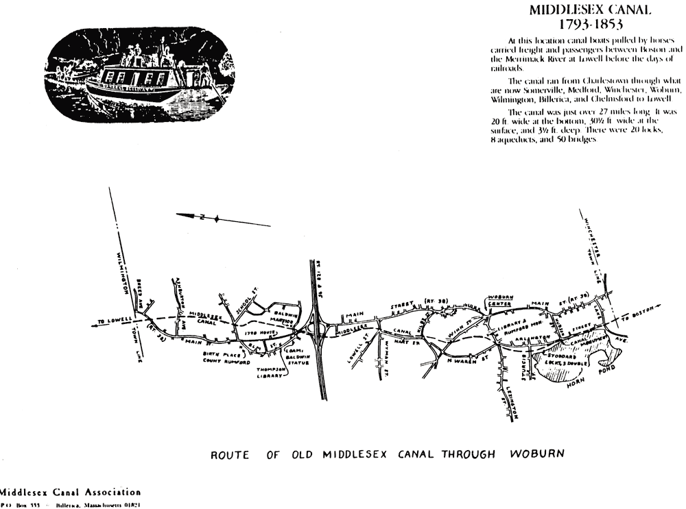
The spring walk this year will cover the Middlesex Canal Route through Woburn. Details of time and meeting place will be mailed to the membership at a later date. However, please mark your calendar now to save the date.
PRESIDENT'S MESSAGE
Many of our recent activities and accomplishments have been well covered in this or previous issues of Towpath Topics, but I would like to mention several other happenings relating to the Middlesex Canal which may be of interest.
On a pleasant afternoon in late September, a small but industrious group from our Association picked up large quantities of debris from our Dignon section of canal in Billerica. We believe the Billerica Boy Scouts will come to our rescue by helping to remove about 3 dozen tires later this spring.
Several of our directors participated in a public hearing in Billerica relating to fencing the contaminated Schaeffer Landfill, which is east of Pond Street and adjacent to an otherwise unspoiled section of the Middlesex Canal.
We understand that Tennessee Gas Pipeline Co. have installed their new, larger size pipe through Wilmington, except for the short piece crossing the Canal at our Webber-Fielding land near Butters Row. There, the pipe reduces from the new 24-inch to the old 12-inch diameter. This is disappointing because it means that the hoped-for replacement of the Canal here is indefinitely postponed (see p. 4 of Towpath Topics, Oct. 1990).
The Woburn Historical Commission, with our former director Tom Smith narrating, has produced an excellent video tape on the Middlesex Canal. It was recently aired by the Woburn and Winchester public TV stations.
As part of their New England bus tour, the Canal Society of New Jersey will be in our area in July. They have invited me and Fran to assist in guiding them to the highlights of the Middlesex Canal.
Burt VerPlanck
President
BALDWIN RESTAURANT OPENS
by Fran Verplanck
Those of you who like to dine out might consider a trip to the new Baldwin Restaurant, which has recently opened in the old Baldwin Mansion at Baldwin Landing on the Middlesex Canal in Woburn. Many of us on the Middlesex Canal Association board have dined there, and feel we can highly recommend the new and wonderful eating there. We were always highly pampered and served by neat, prompt waiters and waitresses. The food is excellent and caters to the slim or hearty eaters; it looks beautiful and tastes superb! And the prices are very reasonable.
The new owners and management are most gracious and cordial and, I should say again, very anxious to pamper you for your special needs. They have done a tasteful and elegant redecorating job.
Many small rooms make a cozy, relaxed atmosphere, and the second floor ballroom at the top of the interesting and historic double staircase can accommodate nicely for parties. So, do go and feel pampered at our favorite Middlesex Canal spot, and meet our wonderful new owners, Dan O'Connell and Charles Eldred.
FALL MEETING - OCTOBER 1990
On Sunday, October 28, 1990, the Middlesex Canal Association held its fall meeting at the First Congregational Church in Billerica. After a short business meeting, Director Martha Hazen presented a slide show on two canal trips she had taken the previous summer. The first trip was on the Erie Canal, in a canal boat rented from the Midlakes Navigation Company out of Cayuga, NY. This week-long trip took her and three others westward along the Erie Canal, through various small towns from Clyde to Pittsford, and then south of Rochester to Brockport, where lack of time forced the turnaround. One of the most interesting parts of this trip was the level crossing of the Genesee River, where the downstream currents made a noticeable impression on the rudder. This crossing is protected both east and west, by two massive guard locks on the Erie. In many towns were lovely mooring locations with lawns and picnic tables. Particularly memorable was the evening of July 4, spent moored at Pittsford (where Martha had relatives living); a lively show of fireworks (artificial) was followed by the real, natural thing accompanied by torrential downpours. Much of Rochester lost power, and the next day a more easterly part of the Canal showed destruction apparently wrought by a tornado. The last part of the trip was on the Cayuga-Seneca Canal, including passage of the two-lock flight between these two lakes. The Midlakes rental canal boats were extremely comfortable, with (rather tight) sleeping accommodations for six (Martha thought four was a more comfortable number), two lavatories and heads, a shower, and a completely equipped kitchen. The Company keeps the boats extremely clean and neat, and well-outfitted.
The second trip that Martha described was a week-long trip on a "hotel boat" from Stoke-on-Trent to Chester, England. The boat was actually two of the traditional narrow boats of just under seven foot beam and 72 foot length, only one of which had a motor. During cruising, the motored boat tows the "butty;" most of the locks they went through only accommodated one boat at a time, so each lock had to be run twice. The locks are all manually operated, without lock-keepers. Passengers and crew alike shared in the locking duties. On one day, the group passed through 23 locks, each twice! The boats were brightly painted, in red, black and green, with roses and castles painted on the stern doors and sides in accordance with tradition. The countryside varied from the pottery mills at Stoke to the sunken fields of the salt-mining country, to the beautiful small river valleys which were often well below the level of the canal. At each small town where they stopped, there was the popular local pub for relaxing after dinner. Starting out on the Trent and Mersey Canal, the tour took the Middlewich Arm west to the Shropshire Union Canal, which led into Chester. The Shropshire Union, especially, was suffering from lack of water due to the terrible drought in England last summer. In one place, a non-thinking boatman had left lock gates open and drained a pound to where there was barely enough water to motor in. The trip ended in Chester, a beautiful old walled city on the west coast of England; the streets of the city are lined with half-timbered buildings in white on black. There are many similar trips offered, both hotel and self-drive, on the hundreds of miles of canals that are usable in the English countryside.
27th ANNUAL OLD MIDDLESEX CANAL WALK
contributed by Bill Gerber
Saturday, October 13, 1990, turned out to be a poor choice for a canal walk. That was the day Tropical Storm Lily paid a call; from mid-afternoon and continuing through the night, she dropped about four inches of rain over our area. But, by late Sunday morning, the day began to turn bright and sunny and warm, and we decided to do the walk anyhow. Alas, because no rain date had been published, only a few people showed up. This turned out to be a blessing in disguise!
Early Sunday afternoon, about a dozen people assembled at the Hajjar School in Billerica. When all had arrived, we walked a short distance to the Concord River Dam, next to the Faulkner and Talbot Mills. It was here that the Middlesex Canal crossed the Concord River on the famous floating towpath. Also, because the Concord formed the Canal's summit level, it provided all the water used by the Canal's northwestern and southeastern extensions. We examined a portion of the stone guard-lock that served the northwestern extension to Lowell. Although most of this lock is now covered by a parking lot, the original walls and the insets for the gates are still visible. Down by the river, we also found the iron rings that anchored the northwestern end of the floating towpath, and the spit of land by which the towpath extended from the southeastern shore.
After these explorations and related discussions, we retraced some of our steps, pausing to examine the inlet to the Canal on the southeastern shore of the river. There would have been a guard lock at this inlet, too, similar to the one by the Talbot Mills, and there may have been "log locks" (possibly "flash locks" for the passage of rafts of logs). That there is little or no sign of either suggests that they were probably "quarried" for stone to build the foundations of nearby buildings.
The Rogers House, which may have been the Toothaker Tavern, stands on the side of Rogers Street opposite the inlet. (At least one other nearby structure seems to vie for recognition as the Toothaker Tavern.) This would have been an operating tavern when the Canal was still open. Next to the Rogers House, we picked up the towpath heading toward the Billerica railyards. Where the towpath was continuous, this was a pleasant woods walk along a well-defined and watered stretch of canal. Part of this route passes through the "deep cut," an area where the early canal builders found it necessary to dig a deep trench to maintain the Canal on a level with the Concord River. Continuing east on the towpath, we quickly came to and crossed a section of rail line, and then High Street a short time later. A short distance beyond High Street, we came to the railyard, where our problems began.
We experienced only minor difficulties getting into the railyard, but once in, flooded areas made it increasingly difficult to remain close to the Canal. Soon we were forced to search for an alternative way through the yard. While doing this, we took many wrong turns and eventually lost complete track of the Canal. (At one point, I tested a possible route out only to discover that the water was a bit over waist-deep!) In the end, we made it out to Pond Street, some walking the rails to keep from going too deep into the flood waters and others of us simply "sloshing" through them. But even railwalking was only partially successful, and it was a wet-footed and bedraggled looking crew that emerged at the east end of the railyard.
From Pond Street, we were again able to find the Canal. After looking back to see where we should have came out (though, because of the flood waters, we couldn't have walked this section either), we located the towpath and proceeded to hike on to Gray Street. Like the earlier portion, the section of the Canal between Pond and Gray Streets is a pleasant walk along well defined sections of canal throughout.
With all the time we spent trying to find a route through the railyard, the sun was getting low in the sky when we reached the end of our walk at Gray Street. It had been a very long and soggy four miles since we started. By then, the wettest of us had dried out a little, so we only presented a moderate threat to the upholstery of Burt VerPlanck's car when he shuttled us back to our starting place! En route back, part of the conversation centered on what a disaster the day might have been if the turnout had been larger, instead of a very small one!
WINTER MEETING 1991
On Sunday, February 10, 1991, some 60 members of the MCA and friends overflowed a parlor of the Winchester Unitarian Church to hear a superb, three-part presentation on "The Locks and River North of Lowell." Bill Gerber began with a very succinct and informative presentation summarizing the physical characteristics of the canals and locks along the Merrimack in northern Massachusetts and New Hampshire. Wil Hoxie followed with an excellent historical overview, including a dateline from 1798 to 1837, when the last canal was built, north of Concord. The final speaker was Charles Mower, a New Hampshire-ite, who has been researching these canals and locks for many years. Mr. Mower has personally visited the sites of all the canals, and he provided us with a fascinating slide show, graphically depicting the remains. An article on this subject by Charles Mower begins on page 11 of this issue of Towpath Topics.
The following article about the MCA is reprinted by permission from The Suburban News, January 9, 1991.
MCA MEMBERS SHARE LOVE OF HISTORY
by Sharon Iovanni
As you stroll along the remains of the once great waterway, you can almost picture the packet boats loaded with festive passengers making its lazy way north; the small boys, their feet dangling over the canal's sides, testing their fishing skills; the men, wading in water touching their hips, reaping the long grasses growing from the canal bed.
"I think of that as I walk along the canal, how it must have been," says Middlesex Canal Association member Martha Hazen. The editor of "Towpath Topics," a bi-annual publication of the association "sees the world from a different point of view ... the parts (of the canal) that are left are very countrified ... it's serene, peaceful."
The Middlesex Canal Association (MCA), incorporated in 1964, is dedicated to preserving and restoring what remains of the canal and to publicizing the canal's history.
The canal, which stretched from Charlestown to Lowell was not only a major accomplishment in its own right, but also host to a variety of inventions and discoveries.
According to former MCA President Arthur L. Eno, Jr., in his introduction to "The Old Middlesex Canal: it was "one of the earliest examples of private business corporations, an early public utility (with the right of eminent domain) ... and a proving ground for the civil engineering profession."
It was also a source of many fascinating stories ... for instance, the discovery of the Baldwin Apple. According to "The Old Middlesex Canal," written by Mary Stetson Clarke, histories of the canal indicate that in August of 1793 a surveying party - comprised of Samuel Thompson, Loammi and Benjamin Baldwin and James Winthrop - set out to investigate the land and find the most beneficial route for the proposed canal from the Medford Bridge to the Merrimack River.
Near Chestnut Street in Wilmington the party noticed a flock of woodpeckers drilling the fruit of a wild apple tree. Loammi Baldwin, for whom the apple was eventually named, became so enamored of the deliciously tart, juicy apple that he planted orchards of the tree on his estate and gave grafts to friends and neighbors throughout the area. A plaque on Baldwin's statue in North Woburn testifies to the importance of the Baldwin apple in the development of the New England economy.
MCA member Frances Ver Planck recommends several other points of interest along sections of the now-defunct canal. In Woburn, the Baldwin House stands on Route 38 and a replica of a packet boat docks in Horn Pond by the electric and pumping stations. She also suggests that a pleasant walk through the Wilmington Town Forest Park will bring you to "Ox Bow Bend" where you can actually see rope grooves in several boulders that remain and to the pier and abutments of Maple Meadow Brook Aqueduct, which was rebuilt in the 1930's.
MCA President David Fitch's walks along the canal have given him "more perspective about how industry developed in the area and how the changing patterns of what we do affects those industries." Fitch says he would like to see the canal bed developed for use as a recreational spot, providing areas for jogging and biking (he stresses that this would not mean dirt bikes, which tear up the bed and walls); and he points to historical diaries that talk about ice skating on the canal in winter.
Wilmington resident and MCA member Betty Bigwood enjoys walking along several sections of the canal in her own hometown. "Today, with so much development, its hard to find areas where you can walk in the woods and enjoy the beauty of the trees, the wildflowers and wild birds."
She says that novices would enjoy the walk from Butters Row to the Wilmington Town Forest Park. The association can provide further information on areas to walk, and Clarke's book offers a very detailed description of the entire canal with directions for walking the areas accessible to the public.
UPDATE ON THE TENNESSEE GAS LINE PROJECT
by Betty Bigwood
As described in previous issues of Towpath Topics, the Tennessee Gas Company, replacing a gas pipeline, was once again to bisect the Canal at Butters Row in Wilmington. We expected the entire project and restoration of the Canal to be completed by this edition. Instead, the saga continues:
Alas, the Tennessee Gas Co., unable to receive Federal Historical Commission and Office of Pipeline Producers Regulation permits to pass through the historical Canal area by early fall, decided to tie the larger pipe on each side to the old smaller diameter pipe under the Canal using a reducer, covered up the area and left. I recently spoke to Mr. David Hartman, a Tennessee Gas Right of Way Agent, and asked him in view of the mild weather we had, why didn't they stay? He replied that they had to deal with the worst weather scenario, and that, because of cost, they felt they had to terminate the project. Furthermore, they were not sure they would return to the area in 1991 - indeed, other construction projects in our general area would be undertaken at a later date - maybe 1992 - and at that time, when their equipment was in the area, they would complete the Butters Row project.
Over the years, I've watched towns, private citizens, and developers destroy sections of the Canal against as much opposition as the MCA could muster. So, what happened here? Well, it seems that the Federal agencies have had massive funding cutbacks, and that they are backlogged and there simply wasn't sufficient time to review the project. Hence, no stamp of approval. This is an expensive delay for the Tennessee Gas Company.
BOOK NOTE
by Martha Hazen
New York State Canal Guide - Western Region by Jeremy G. Frankel and Capt. Peter Wiles, Jr., has recently been published by the MidLakes Navigation Company, Ltd. This guide covers the Western Section of the Erie Canal, from Tonawanda eastward to just beyond Syracuse. This is the book you must take on any boating trip through these waters; there are detailed maps of the canal along the way, and for each town there are lists of places to moor, restaurants, and services ranging from post offices to laundromats. The historical and scenic features of each town are also described. And the introduction contains comprehensive historical material, practical information on canal navigation, and, among other things, a list of wineries in upstate New York. The book is not only useful to boaters; bicyclists and automobile tourists will find it extremely helpful in exploring the Canal area.
When, in the summer of 1990, a group of us rented a boat from MidLakes, we were provided with a looseleaf (and earlier) version of much of the text of this book. We found it immensely helpful. Although navigation maps of the eastern Erie Canal are available, none are in print for the area west of Rochester. This book partially fills in that gap. It would, however, be helpful to have the occasional buoy location number marked on the maps for those of us who tend to "turn off" for a while and then try to find out how far we have gotten.
This New York Canal Guide - Western Region may be ordered from the MidLakes Navigation Co, Ltd. at Box 61 Skaneateles, NY 13152 (1-800/255-3709) or from Jeremy Frankel, P.O. Box 2414, Glens Falls, NY 12801. Price is $19.95 (NY residents add $1.40 sales tax) plus $1.50 P&H (additional copies to same address are $.50 P&H).
EARLY CANALS ON THE MERRIMACK RIVER
by Charles H. Mower
In 1793, New York was the marketing capital of the Americas and fast becoming the busiest port in the world. New Hampshire was rural America, abounding with vast stands of timber and sparsely dotted with agriculture. The industrial city of Lowell was yet unborn and the great port of Boston had a population of twenty thousand. Among these Bostonians was a small group of men with an immense dream. They had decided to make Boston the marketing capital of the world by opening the natural resources of the vast interior. So, on June 22, 1793, the Middlesex Canal Corporation was formed. The first step toward a system of cheep, efficient transportation was taken.1
The idea of canalizing New England was an extensive proposal. A canal between Boston and the Merrimack River had already been determined to be feasible.2 Once the river was opened, there would be no end to what could be accomplished in time. By use of the Baker River and Indian Pond, communication with the Connecticut would be reached at Oxford.3 From there, one could travel across to Lake Champlain, through its outlet into the Saint Lawrence and establish inland water trade with Montreal and the Maritime Provinces.4 However, the geographical obstacles proved too great, and only trade with the Merrimack River valley was ever achieved.5
Utilizing various ponds and streams, the first part of the canal system was constructed from Charlestown to Chelmsford. This was known as the Middlesex Canal. When finished in 1803, this artificial waterway was thirty feet wide, three and one half feet deep, and in its length crossed by seven aqueducts and more than fifty bridges. By the use of twenty unique locks, a total rise of one hundred four feet was accomplished. Meeting the original building cost of $500,009, 6 the first feat of Civil Engineering in America was completed.7
Having completed the first sector of the system, the proprietors turned their labors to overcoming the natural falls and rapids of the Merrimack River. This was accomplished by a series of locks and short canals that bypassed eleven separate falls between Lowell, Mass. and Concord, N.H. The first of these falls was at Tyngsboro. The rapids were too shallow and fast to allow passage, so a small waterway that separated Tyng's Island from the shore was widened and dredged into a simple canal. This was known as Wicasee Falls, and is no longer perceptible due to the dam at Lowell having raised the river level. However, the canal is the stream on the east bank of the island, which is now a Tyngsboro Country Club.
Fifteen miles upriver was the next fall. This was known as Cromwell's Falls and was surmounted by a single lock. Boats were lifted about six feet at this point and poled through a canal of several hundred feet back into the river above the rapids. The diary of John Bowers, born in 1840, tells the following:
The river falls thirty feet in about half a mile here at Cromwell's Falls, down by our meadow land and when I was a little boy, the old locks there were kept up and there was a little house where the lock tender lived. I remember once that we heard there was a drowned man found there and Pa and I went down. It seems a stranger had come to the house the night before, late, and asked to sleep, and Chase, the lock tender, had put him up. He took his clothes off and went to bed, but the boy heard him get up in the middle of the night and when Chase went to the gate in the morning, there he was drowned. Chase got a rope around him and tied him to a stake until the body was lying there swashing up and down in the water. They never found out who he was and the Town buried him.
Today this lock and canal are perhaps in better condition than any other on the river, and are located in Merrimack between the waste water facility and Anheuser Busch.
Moor's Falls was reached next and had a lengthy system to circumvent the long stretch of falls and shallow, swift water. Entering a single lock, a boat was lifted four feet to a canal which stretched upriver a quarter of a mile to another single lock. This lock lifted a boat approximately six feet into the long exiting canal above the falls. These works covered almost a half mile of river and were located in Litchfield. The remains are still visible from the B&M Railroad a few hundred yards above Reed's Ferry.
Between here and Manchester, four more falls were overcome with the use of locks and canals. They were: Cohas, Goff's, Griffins, and Short Falls. Remains are seen at all these locations. Just before reaching the well-known Amoskeag Canal was the canal at Merrill's Falls. Here the water was so shallow that they were forced to build an oblique dam across the river about one and a half feet high. In summer the water was thereby channeled to a simple canal on the east shore. In times of high water, they could simply go over the dam. Today, a look from the Granite Street bridge will show you the canal.
The Amoskeag Canal at Manchester was the resultant work of the Hon. Samuel Blodgett, who conceived the intricate works necessary to lift boats fifty-six feet over the Amoskeag Falls, and brought his work to fruition in 1807. It was to set the foundation for the greatest textile manufacturer in the entire world, and as an engineering feat, it was second only to the Middlesex. Shortly after its completion, Sam Blodgett died and the benefits of his great canal were reaped by the Merrimack Boating Company, who purchased the Blodgett interests.
There were only two falls left on the river. One was at Hooksett and one was at Bow. Both were overcome by extensive locks and canals. Today at Hooksett, a trained eye can follow the vague path and the few stones that are still left. And at Bow, only the upper canal is left, although fairly good, the rest having been destroyed in the construction of the mills and subsequent hydroelectric facilities.
Isaac Riddle of Bedford, N.H., was one of the first proprietors of boating on the river. He was the building superintendent of the Union Lock and Canal Company, and supervised the construction of the locks and canals from Litchfield to the Amoskeag. Credited with having made the first canal boat on the river, Isaac, along with Caleb Stark, drew the boat on wheels from Bedford Center to Besswood landing with the use of forty yoke of oxen. Christened the "Experiment," it was loaded, launched, and sent to Boston, where it was greeted with cheers and cannon fire.8
The village of Indian Head also claimed title to the first canal boat, which was constructed in the spring of 1803 by Robert Fletcher. The boat was quite large with sides five or six feet tall all around, interrupted only by doors. On July 4, with the spirit of the day, she was launched and christened the "Nashua."9
In 1816, the following handbill was circulated:
June 15, 1816
BOATING TO CONCORD, N.B.
By the Merrimack Company's boats is now begun. Two convenient stores are erected in Concord, N.H., one on the west side of the river, near the bridge, the other on the east side, near the upper bridge. A capable trusty man is employed at each place to take charge of the goods and deliver them to the order of owners, and to receive produce, merchandise, and lumber to be sent down, preference given to the merchandise. The loading will be delivered in Boston at the landing at the Almshouse wharf, Leverett St. to the order of the owners, settlement being made for the freight, and loading to go up is received there every day in the week. The goods first entered and settled for will of course go first. The boats for the present load every Tuesday and Friday, as heretofore, and when there shall be business enough every day.
The Company has never made any charge for storage; the whole expense is $13.50 per ton, to the upper landing at the upper bridge in Concord, and 8½ dollars down, 13 dollars to the lower bridge in Concord and 8 dollars down, 12 per ton to Pembroke, 7½ dollars down, 7 dollars per ton to Merrimack, 6 dollars down.
As everything will be done to make this mode of conveyance regular and convenient to gentlemen in the country, we feel confident of giving them satisfaction. When desired, the keeper of the landing in Boston will procure their goods to be trucked there. Information respecting the boats will also be given at No. 7 India Wharf.10
John L. Sullivan
Agent for the Company
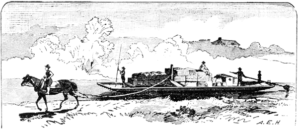
Although these and other boating companies were independent, the size of all boats on the river was regulated by the Middlesex proprietorship. They could be no less than forty feet in length and no more than seventy-five. Width could not be greater than nine and a half feet nor less than nine. A boat of this size was capable of hauling fifteen tons of freight and was usually named by a crew of three.11
A Steersman, who was in command, would stay to the stern and operate a large sweep while shouting orders to the polemen. The polemen used a winched pole approximately twelve feet in length to propel the boat. Thrusting the pole into the river bottom at the bow of the boat, they would hold fast and plod back along the stern, literally walking the boat upstream. More enterprising boats had sails, which, when conditions prevailed, enhanced the leisure of the crew a great deal.12 In 1830 a boatman made fifteen dollars a month and a steersman as much as two dollars a day.13
Besides freight boats, there were luggage boats, passenger boats, and lumber rafts, frequently called "shots," in regard to their speed in descending the rapids. Usually there were seven to ten shots in a drive, and they were manned by five men and a driver per boat.14
As in all transportation, traffic rules applied. Luggage boats could proceed no faster than two and a half miles an hour. All others could clip along at four miles per hour. There was no passing and no racing. Fines were imposed if caught. One account of two men from Litchfield racing home ended in the winner, Captain Israel Merrill, winning by the length of one boat and the loser dropping dead from his exertions.
Captain Israel Merrill received a gold medal for saving the lives of two men from the grasp of the river:
John McCutchens, afloat on a raft of lumber above Eel falls and finding it getting beyond his control, leaped into the water to attempt to swim to the bank. Unable to do this he was carried over the dam, built just above the falls, but managed to catch upon a wooden pin on the top of the planking. Captain Merrill, seeing his perilous situation, swam down to the place and pulled him to a rock from which they were rescued. Matthew McCurcy fell into Pulpit stream and was swept down against a jam of logs, where he clung until Captain Merrill swam to his assistance.15
Joseph M. Rowell was the John Henry of the Merrimack River. He is known to have rafted two lots of lumber from Amoskeag mill No. 5 to Litchfield, nine miles away, and walked back each time with a forty pound scull oar on his shoulder. This was considered a double days' work, for which he received the sum of three dollars. He, also with John Ray, is said to have made the quickest trip to Boston on record:
On June 30th, 1833 at eight o'clock in the morning, their boat passed Bass island at the mouth of the Piscataquog River. They proceeded to the Medford river, back into the Middlesex Canal and on into Boston. They loaded and returned home, arriving on the evening of July 3. He had completed a round trip in four days. The average trip was three days down and four days back up).16
Sounding horns for the lock tender on Sundays and navigation at night were strictly forbidden. Taverns were built and leased by the Corporation, some for as much as seven hundred dollars.17 Certainly, this was a more spirited part of a boatman's day, when "flip" and "black strap" flowed freely between conversations and the news of the day was passed along. It was one of these very taverns which led Henry David Thoreau to say, "The church is the place where prayers and sermons are delivered, but the tavern is where they are to take effect and if the former are good, the latter cannot be bad."18
By 1814, all rapids and falls on the river had been surmounted. Low water and eel beds were the only obstacles left. Eels, when spawning, make small piles of rocks in which to lay their eggs. When a boat became grounded as on one of these piles, the boatmen would stand on the bow and rock back and forth until the pile crushed and they could sail on.19
Resources were flowing into Boston. Granite from Tyngsboro and Concord; brick from Merrimack, Reed's Ferry, Bedford and Hooksett; and manufactured items such as clapboards, shingles, hogshead staves, barrels, and nails, floated down river. An infinite amount of timber for shipbuilding in Mystic and Charlestown poured down to the sea. Upriver came West India goods, dry and wet, salt, lime, plaster, bar iron, pig iron, slate coal, glass, paint, oil and hardware. The face of the Merrimack River really was changing.20
From 1819 to 1835 were the untroubled days of canaling. No longer were there any debts to pay and there was little operating expense as all the locks and canals had been improved with stone. In these pastoral days it was impossible to know the end would come so quickly. But technology had spelled the extinction of boating, with the invention of the railroad, a conqueror of time and speed. In 1835, shadowing the canal most of the way, the Boston to Lowell Railroad was completed. Ironically the very ties used in laying track were provided on site by canal boats.21 Boating declined sharply over the next decade and became practically nonexistent with the completion of the railroad from Nashua to Concord in 1842.22
Finally, on October 3, 1860, the Massachusetts Supreme Court decreed the Proprietors of the Middlesex Canal had forfeited all franchises and privileges by reason of nonfeasance, non-used misfeasance and neglect.23
No longer would hardy boatmen sing out their "HALLOO." Their boats would no longer speckle the river in busy commerce. Just as surely as the canal had progressively changed New England, the same process of change had overcome the canal. The railroads were here to stay and the golden age of canaling was gone forever.
1. Lorin L. Dame, "The Middlesex Canal," Mass. Meg. (Boston: Cop-plea, Upham and Co., 1886) Vol. II.
2. Ibid.
3. "New Hampshire, A History" (Lewis Hist. Publ. Co., N.Y. 1927) , Vol. II.
4. C. E. Potter, "History of Manchester" (Manchester, N.H., C. E. Potter, 1856), p. 717.
5. George Stark, "Frederic G. Stark and the Merrimack River Canals," Mass. Meg., Vol. II.
6. Dame, op. cit.
7. Raymond P. Holden, "The Merrimack" (N.Y., Rhinehart and Co., Inc., 1958), pp. 152-158.
8. Peter Woodbury, "History of Bedford" (Boston, Alfred Mudge, 1851), p. 271.
9. Edward E. Parker, ed., "History of the City of Nashua" (Nashua, N.H., Telegraph Publ. Co., 1897), p. 134.
10. Granite State Hag., "The Merrimack as a Maritime Way" (Manchester, N.H., Granite State Publ. Co., 1906), Vol. I.
11. Dame, op. cit.
12. L. Ashton Thorp, "Manchester of Yesterday" (Manchester, N.H., Granite State Press, 1939), pp. 18-20.
13. Dame, op. cit.
14. Stark, op. cit.
15. Granite State Msg., op. cit.
16. Ibid.
17. Dame, op. cit.
18. Henry David Thoreau, "A Week on the Concord and Merrimack Rivers" (N.Y., Hurst and Co.).
19. Stark, op. cit.
20. Dame, op. cit.
21. Stark, op. cit.
22. Thoreau, op. cit.
23. Dame, op. cit.