
Middlesex Canal Association P.O. Box 333 Billerica, Massachusetts 01821
www.middlesexcanal.org
| Volume 53 No. 1 | September 2014 |
MCA ACTIVITIES
Please mark your calendars.
MCA and friends are sponsoring a bicycle tour of the canal, north from Charlestown, on Sunday, October 5th.
The MCA-AMC Fall Walk will take place in the Billerica and Chelmsford area on Sunday, October 19th.
Our Fall Meeting will be held on Sunday, October 26th, 2014, in the museum, beginning at 1:00pm. Our speaker will describe potential plans for revising Sullivan Square. Refreshments will be served following.
See the Calendar, following, for more information on our activities. Also included are meetings and tours, sponsored by other canal and related organizations, in which you may want to participate.
Please also check our web site now and then, at the URL noted above in the nameplate, which also lists canal-related events and topics of potential interest, sometimes including those that don’t make it into Towpath Topics.
TABLE OF CONTENTS
President’s Message (J.J. Breen)
Calendar of Events
For Future Planning
Arthur L. Eno, Jr. RIP (Bill Gerber)
Arthur L. Eno, Jr. Obituary (Lowell Sun)
MCA Photo Archive (Bob LeBlanc)
Extracts from “History of Chelmsford” by Rev. Wilkes Allen
Sullivan Square (Howard Winkler)
Canal-side Landings (Bill Gerber)
The Quincy Canal (H. Hobart Holly, Quincy Hist. Society)
Miscellany
PRESIDENT'S MESSAGE
by J. Jeremiah Breen, President; jj@middlesexcanal.org
“I’m not fixing the roof! How would you like the building?”, Bill Donovan, president of Pace Industries’ Cambridge Division in the Talbot Mills, exclaimed when Tom Raphael visited him to discuss plans for the Middlesex Canal Park. The Billerica Historic Districts Commission had formally notified Pace of the need to repair the building’s dilapidated roof. The quote is from the minutes of the April 4, 2012 meeting of the board of directors. The motion to (1) accept the gift of the building, as is; (2) with the land under the building; (3) with as much more land as we can get; and (4), before seeing the interior of the building, was approved at the next meeting.
Location of Gift across Canal from Proposed Middlesex Canal Park
The building is at 2 Old Elm Street, Billerica 01862. In the story of the canal, it is at location of the ceremonial groundbreaking, September 10, 1794, which made simple the decision for some directors to vote yes on the motion to accept the gift, in keeping with Loammi Baldwin’s prayer, “May the Eye of Wisdom and the Eternal Mind aid this work designed for the benefit of the present & all Future Generations”, at this location 220 years ago.
Based on a photo in Hazen’s History of Billerica it was built before 1883. The stone foundation is likely laid on a continuation of the ledge which makes the Billerica Falls. An 18” high granite sill tops the foundation. Its top is 1.7’ above the 100-year flood elevation of 114.8’. (Roald Haestad, Inc., Table 1, Effective FIS, NGVD of 1929). The double wythe brick walls are 18” thick. The building was used to store the finished wool cloth from the Talbot Mills, the valuable end product of a costly process from sheep to warehouse. The Talbots carefully chose the location and built to last over 130 years.
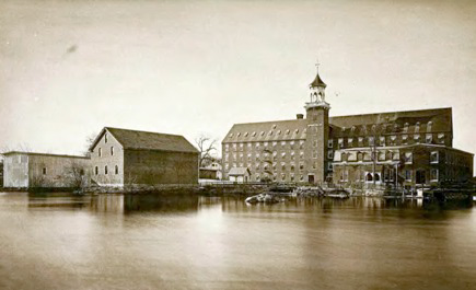
Talbot Mills, Hazen’s 1883 History of Billerica
The stone and brick have lasted 130 years. The wood has rotted under the leaking roof. The building needs to be gutted and the roof replaced. Since March 6, 2014, the date the transfer of the building was completed with the recording of the deed (book 280036, page 214), the board of directors has authorised a contract with a fundraiser, and sufficient funds are anticipated that the board has met with a structural engineer, Tom Raphael’s friend, and the architect who works with him. The architect’s contract for preliminary plans is on the agenda for the September meeting of the board of directors.
One preliminary plan would be based three, 9-foot floors with the first floor at the top of the granite sill. As the brick wall under the eaves is 21½’, the new roof would need to be 5½’ higher through a combination of masonry and windows. If the roof pitch were flattened from the existing 6” vertical: 12” horizontal to 3 on 12, the peak would not be much higher. Each floor is 2100 square feet, the same as the Reardon Room, including kitchen and rest rooms, and only slightly smaller than the exhibition room. In other words, the future Middlesex Canal Visitor Center is 50% larger than the first.
J. Jeremiah Breen
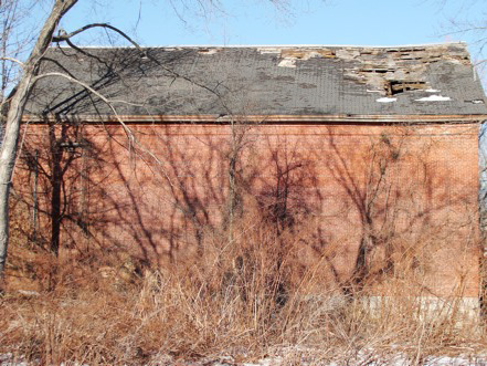
South Wall, February 2014
CALENDAR OF EVENTS
Middlesex Canal Association (MCA) and Related Organizations
The Middlesex Canal Museum and Visitors’ Center is open every Saturday and Sunday, noon-4, except holidays.
First Wednesday - MCA Board of Directors' Meetings - The Board meets at the Museum, from 3:30 to 5:30pm, the first Wednesday of every month, except July and August. Members are always welcome to attend.
Directions to the Museum/Visitors Center: Telephone: 978-670-2740.
By Car:
From Rte. 128/95, take Route 3 toward Nashua, to Exit 28 "Treble Cove Road, North Billerica, Carlisle". At the end of the ramp, turn left onto Treble Cove Road toward North Billerica. At about ¾ mile, bear left at a fork. After another ¾ mile, at a traffic light, cross straight over Route 3A. Go about ¼ mile to a 3-way fork; take the middle road, Talbot Street, which will put St. Andrew's Church on your left. Go about ¼ mile and bear right onto Old Elm Street. Go about ¼ mile to the falls, where Old Elm becomes Faulkner Street; the Museum is on your left and you can park across the street on your right, just beyond the falls.
From I-495, take exit 37, N. Billerica, south to the road's end at a "T" intersection, turn right, then bear right at the Y, go 700' and turn left into the parking lot. The Museum is across the street.
By Train: The Lowell Commuter Line runs between Boston's North Station and Lowell's Gallagher Terminal. Get off at the North Billerica station, which is one stop south of Lowell. From the station side of the tracks, the Museum is a 3-minute walk down Station and Faulkner Streets on the right side.
Saturdays, Sept 27, & Oct 11 & 25, 2014. Canal Heritage Days, Waterloo Village, Stanhope, NJ. Boat rides on the Morris Canal. Museum open. Call 973– 292-2755 or see njcnal@googlegroups.com for more information.
Sun-Tues, Sept 21-23, 2014. Canal Society of New York State, New York State Canal Conference. Based in Geneva, NY at the Ramada Geneva Lakefront Hotel in the spectacular Finger Lakes Region! On Seneca Lake and the Cayuga-Seneca Canal. For further details, see www.newyorkcanals.org/explore_canalconf2014.htm.
Walks along the Delaware & Raritan Canals in New Jersey. Various Saturdays. Sponsored by the D&R Canal Watch. For additional information contact Bob Barth at 201-401-3121 or bbarth@att.net.
Sat, Oct 4, 10am (Walk 7) D&R Canal towpath from Carnegie Road to Cadwalader Park, Trenton 6.0 miles. Meet at Ellarslie Mansion (the city mansion) in Cadwalader Park, Trenton; then we will travel to the starting point. A shorter, 2.4 mile hike will be available.
Sat, Nov 8, 10am (Walk 8) D&R Canal Feeder from the Ellarsie Mansion in Cadwalader Park to the junction with the main canal at Old Rose Street, 3.8 miloes. Meet at Ellarsie Mansion (the city mansion) in Cadwalader Park, Trenton. See the Pedicaris waste gate and bridgetender’s homes.
Augusta (GA) Canal, Guided Bicycle Rides - “Pedal through the Past”. Bring your bike and enjoy a ride along the canal towpath with an experienced Augusta Canal tour guide. Learn a bit about the history, engineering and natural surroundings that make the Augusta Canal a National Heritage Area. For information see http://www.augustacanal.com/Default.aspx?PageId=9.
Sun, Oct 5, 2014. Bicycle Tour of the Historic Middlesex Canal. MassBike, the Somerville Historic Preservation Commission, the Middlesex Canal Commission and the Middlesex Canal Association will sponsor the 12th annual bicycle tour of the canal which was the “big dig” of late 18th century Massachusetts. Completed in 1803 after 10 years of construction, the Canal connected the Merrimack River, west of what is now Lowell, with the Charles River at Sullivan Square in Charlestown. The Canal provided passenger and freight service for 50 years. It pioneered many innovations and in many ways served as a model for later canals, notably including the Erie Canal.
We will meet at 9:00am by the Canal marker at the Sullivan Square MBTA station. From there we will ride about 28 miles to the Mill Village and Canal Museum by the Concord River Millpond in North Billerica. We’ll stop for lunch in Woburn, so please bring a lunch. We should get to North Billerica in time for anyone who wants to catch the 3:07pm train back to Boston. The ride will then follow the northern section of the Canal another 10 miles to Lowell in time to catch the 5:00pm train back from there.
The ride will be an easy one for most cyclists; the route is pretty flat and we will average 5 miles per hour. Along the way we will stop at: several canal remnants and restored sections; the Mansion of Loammi Baldwin, chief engineer for the Canal (for whom the Baldwin apple is named, discovered during an early canal survey); the two remaining aqueducts (which carried the Canal over rivers and brooks); and the northern end of the floating towpath that enabled horses to tow boats across the Concord River.
The ride will be led by Dick Bauer of the Somerville Historic Preservation Commission and the Middlesex Canal Commission, Robert Winters of the Middlesex Canal Association, and Bill Kuttner of the Shirley-Eustis House and the Middlesex Canal Commission. Steady rain cancels.
For more information, contact Dick at dick.bauer@alum.mit.edu (617-628-6320); Robert at robert@middlesexcanal.org; or Bill at bkuttner@ctps.org (617-973-7132). For more information about the Middlesex Canal go to: http://www.middlesexcanal.org, &/or http://www.massbike.org/resources/rides.htm.
Wed-Mon, Oct 8-13, 2014. Chesapeake & Ohio Canal Association - Through Bike Ride, Cumberland to Georgetown. No sag wagon provided. Reservations required. Limited to 20 riders. Contact: Pat Hopson, 703-379-1795 or phopson727@verizon.net.
Weekend, Oct 17-19, 2014. Fall 2014 Pennsylvania Canal Society Fall tour of the Eastern Morris Canal in New Jersey. For more information see www.pacanalsociety.org or Contact Bob Barth at 201-401-3121; barths@att.net.
Oct 17-18, 2014. Canal Society of Ohio, Fall Tour along the Hocking Valley Canal, southeast of Columbus, of Logan, Lancaster & Carroll. The tour will include: Logan Falls and State Dam; the towpath cut into bedrock (in the famous photo of the Maggie Case canal boat); “Sheep Pen” lock south of Rockbridge; Locks 9 & 10 at Sugar Creek; “Ream’s Mill” Lock; a drive by Lancaster Locks 1 to 4; Long Lake, the last watered section of the Hocking Canal; and Carroll Canal Basin. The tour headquarters will be at the Holiday Inn in Logan, and the Banquet will be at the Old Dutch Restaurant in Logan. David Meyer and David Neuhardt David.Neuhardt@ThompsonHine.com.
Sun, Oct 19, 2014: Joint Middlesex Canal Association - Appalachian Mountain Club Fall Walk. This walk is jointly listed as a Local Walk of the Boston Chapter of the Appalachian Mountain Club (AMC). “Show and Go”; meet at 1:30pm at the Middlesex Canal Museum and Visitor Center at the Faulkner Mill at 71 Faulkner Street in North Billerica. The Museum and Visitor Center, including the bookstore, will open at 12 noon. The 2-2½ hour walk will cover part of the Merrimack branch of the canal in Billerica and Chelmsford, about 3 to 4 miles over generally level wooded terrain and streets. Sites to visit en route will include a guard lock, the anchor stone for the floating towpath that bridged the Concord River, and many stretches of watered canal. For directions to the museum, Middlesex Canal signs point the way, or see the third paragraph under this “calendar of events” section, above. Information: contact Robert Winters (robert@middlesexcanal.org) or Marlies Henderson (978-663-3345).
Weekend, Oct 23-26, 2014. The Society for the Preservation of Old Mills, annual conference at the Rochester Hills Museum, Van Hoosen Farm, Rochester Hills, Michigan. The site is about 90 minutes from the Toledo area. The conference will feature tours visiting local mill sites, adaptively reused mills, moth balled mills, and working mills. On Thursday, an optional tour will trace the path of the Clinton and Kalamazoo Canal, Michigan’s first internal improvement project dating from 1837. Canal boat tours listed in the Spring 2014 American Canals. For more information, visit www.spoom.org.
Sat, Oct 25, 2014. Chesapeake & Ohio Canal Association - Annual Heritage Hike. Hikes of varying lengths will be offered from the Pearre WMRT parking lot, followed by an evening dinner and program. Details will be published in the September newsletter. Contact Christine Cerniglia at programs@candocanal.org.
Sun, Oct 26, 2014. Middlesex Canal Association Fall Meeting will be held in the museum, beginning at 1:00pm. Our speaker will be Skip Smallridge. Mr. Smallridge is a principal of the professional partnership of Crosby, Schlessinger, and Smallridge, a firm specializing in landscape architecture, planning, and urban design. This firm developed the Sullivan Square landuse plan for the Boston Redevelopment Authority in anticipation of the proposed reconstruction of the road network in that area. The overall planning effort and ideas suggested for historical interpretation will be covered in the presentation. Refreshments will be served following the presentation.
Weekend, Apr 24-26, 2015. Pennsylvania Canal Society tour of Western Pennsylvania canals. The annual meeting of the American Canal Society will be held in conjunction with this tour.
Weekend, Apr 28-30, 2015. Canal Society of Ohio golf cart tour of Stark County. Jim Guest, jeguest@prodigy.net.
Tentative Dates for future MCA activities are as follows:
Sunday, February 8, 2015 - Winter Meeting
Saturday, April 11, 2015 - Bicycle tour of the canal, south from Lowell
Sunday, April 26, 2015 - MCA-AMC Spring Walk, TBD
Sunday, May 3, 2015 - Annual Meeting
These dates may change slightly based upon the personal schedules of trip leaders and speakers. Please check website a few weeks before for any changes.
Arthur L. Eno, Jr. RIP
1924 - 2014
Attorney Arthur “Louie” Eno, founding member and first President of the Middlesex Canal Association, passed away on August 6 at the age of 90. His obituary, as published in the Lowell Sun, is appended below.
Louie did the legal work to establish the MCA as a recognized organization; he wrote the bylaws and served as its first President for the decade from 1962 to ’72. It was during his tenure in office that Mr. Frank Dignon, of Billerica, generously donated a strip of the Canal, running from Brown Street westerly through his land. The strip is 50 feet wide and almost 2000 feet long. This gift was a memorial to his late wife, Doris Hopkinson Dignon, whose family owned the entire area in East Billerica. Her ancestors had acquired the rights of the Canal Proprietors for the entire section of the Canal from the Shawsheen River to Brown Street and beyond. During this same period many other people also donated a variety of canal-related artifacts; these are listed in various early issues of Towpath Topics and many are on exhibit in the museum.
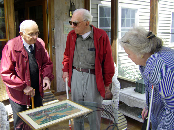
Photo credit - Tom Dahill Tom Raphael, Louie Eno and Betty Bigwood, admiring |
Upon stepping down as MCA President, Louie served, from 1972 to 1974, as President of the Lowell Historical Society where he is known for having edited a well regarded compilation of essays about the Industrial Revolutionera in Lowell, entitled “When Cotton Was King”, published in 1976. Then and in subsequent years, he did title and legal work for land acquisitions for the National Park and the former Lowell Historic Preservation Commission.
Several decades later, Louie again rendered great service to the canal, this time by his assistance to the Middlesex Canal Commission. This all began as a chance meeting in 1994, between Louie and Tom Raphael (MCC Chairman), during a Yankee Doodle Day celebration in Billerica. On that day, several of the MCA’s officers and directors, in the costumes of the early canal builders - Baldwin, Sullivan and others - reenacted the turning of the first shovelful of earth which, in 1794 had initiated construction of the canal. (This was one of a succession of plays, written and directed by David Dettinger, to commemorate early historical events. BTW, we have on exhibit in the museum the actual shovel that was used that day in 1794.) Tom recognized the Harvard jacket that Louie’s wore that day and struck up a conversation; surprisingly, though they hadn’t met before, both men had graduated in the same Harvard class.
Tom needed a lawyer to help him with his MCC projects. Lou offered his assistance. Over the ensuing few years Tom and Louie met many times to work out the details of the easements around the Billerica Mill Pond that they wanted from the then owners - Pace Industry, Bill Donovan and the Martin brothers. It was a tedious and time consuming effort. All this was done pro bono by Louie, and of course by Tom as well.
Louie Eno was a kind and elegant gentleman of the old school, a founder and generous contributor who was always willing to assist us. We owe him an incalculable debt. He will be missed.
Obituary of Attorney Arthur L. Eno, Jr.
1924 - 2014
from the Lowell Sun
Attorney Arthur L. Eno, Jr. was born in Lowell April 27, 1924 and died August 6, 2014, a stone’s throw from where he grew up overlooking the Merrimack River in the city he loved.
As the firstborn son of Arthur L. and Claire (Lamoureux) Eno, Sr. his first language was French. He attended St. Joseph Grammar School and Keith Academy in Lowell, and his childhood buddy was Jack Kerouac, another of Lowell’s Franco-American sons.
While Jack’s destiny was to leave Lowell, Louis’ destiny was to stay. Except for college and the war, he never lived more than 20 minutes from the city. Gifted with a strong intellect and an indomitable work ethic, he was accepted into Harvard at age 14. At the suggestion he prepare a bit more socially, he took an additional year of studies at Phillips Academy Andover.
Never one for dawdling, he completed his undergraduate Classics degree in three years; served in the Signal Section of the Army in Morocco, Italy, France and Germany for three years (he was in Paris at the end of the war); spent a year studying at the Sorbonne and returned to enter Harvard Law School, which he completed in just over two years.
After admission to the Massachusetts Bar in 1948, he became an Assistant Professor of Law at Northeastern University at age 24, just as he was opening his own private law practice in Lowell. Then, for the next 53 years, he commuted every day to the same neighborhood, many of them in his bright orange VW bug. In 1994, he created a firm, Eno Boulay and Martin (now Eno Martin Donahue) and retired in 2001.
In 1957, friends masterminded a fateful meeting with Ann Fitzpatrick of New Rochelle, New York. He called her at her New York City office to ask if she could arrange theater tickets for his girlfriend and him. This interesting tactic somehow worked and he successfully wooed Ann to Massachusetts. While the couple couldn’t have been more different in temperament or outlook, they were married 56 years and raised three children, John, Madeleine, and Will.
One of their proudest achievements was to move a 300-year-old house from Amesbury to Carlisle.. Louis heard that a beautiful old home was up for auction due to the construction of Route 495. He carefully tucked two sealed bids, one low and one high, into his jacket pocket. When it came time to present bids, he forgot which was which, but still managed to win the house. He & Ann dismantled and moved it-board by board, brick by brick-and painstakingly recreated it on acreage in Carlisle.
Civic involvement was important to him, and he served on numerous professional organizations and political groups: the Lowell School Committee (1951-1955), the Lowell Historic Board (1984-1993), and the Middlesex Canal Commission. He was a Trustee of the Central Savings Bank, a Director of the Jeanne d’Arc Credit Union (1972-1992), President of the Lowell Humane Society, President of the Middlesex Canal Association (1962-1972) and President of the Mass. Conveyancers Association (1982-1984).
While law was his vocation, the history of Lowell was his passion. He edited Cotton Was King, a compilation of essays about Industrial Revolution- era Lowell, published in 1976. He translated Immigrant Odyssey from French to English. Antiquarian books, bottles, and artwork all with the common theme of Lowell lined the bookshelves of the living room, and his office was a veritable museum to the city.
His numerous awards include Honorary Oblate of Mary Immaculate (1979), the Richard Johnson Award (Mass. Conveyancers Association), Lawyer of the Year (Greater Lowell Bar Association, 1991) and Franco- American of the Year (2000).
He was co-author of Massachusetts Real Estate (West Group) and editor of annual supplements of the publication for dozens of years. He edited the Massachusetts Real Estate Sourcebook (published by Mass. Continuing Legal Education).
Deeply religious, Louis rarely missed attending Mass, even while traveling. In his rare spare time, he took the family in the station wagon to explore the canals and locks of the eastern seaboard.
Until he lost his sight several years ago, reading was his ultimate pleasure. All he needed for a happy vacation at the family cabin in Vermont was his tall glass of ice tea and a tall stack of library books. He read quickly and remembered details. His 10-year-old daughter once asked him to read Charlotte’s Web so she could discuss it with him. He sat on the porch and read it in a single sitting while she watched. A lifetime classics student, he gave his young children Peanuts books in Latin for Christmas.
He loved lobster, croissants, Paris, Quebec, speaking French, reading the Greek philosophers, sci-fi movies, Bennie Hill, large dogs, and his family. There was very little about the world, history, or politics that he did not know. For the past several decades, he met his friends, Lenny and Jay for lunch, jokes and political talk just about every Saturday. His baby granddaughter was making her entrance into the world at the very moment he departed.
Surviving him in addition to his beloved wife, Ann, are his children John (Jeanne Palanza) of North Andover, Madeleine (John Roper) of Sandy, Oregon, Will (Maria Dizzia) of Brooklyn, NY, and brand-new granddaughter, Albertine Eno. His brother, Paul A. (Janice) Eno of Taunton, MA, and dozens of nephews, nieces, grandnephews and grandnieces, each of whom he adored. He was predeceased by his beloved sister, Jacqueline.
THE MIDDLESEX CANAL ASSOCIATION PHOTO ARCHIVE
(A new opportunity for MCA to preserve Canal History)
by Bob LeBlanc
Many of you who frequent the Canal Museum may have noticed the collection of slides and photos located near the staircase to the basement in our meeting/function room. Basically it has been collecting a lot of dust over the years except when someone is looking for material to add to a presentation, or beginning an effort to sort the Canal photos.
One of our Directors, Russ Silva, has been working to make these photos easily accessible and to reduce the need to handle the original material (thereby protecting them from accidental damage). Over the past several months he has been digitizing the extensive collection of slides.
This activity started out as an ad hoc effort to preserve the images in digital form before time, or calamity, caused them to be lost. As such, there was no formal plan to catalog them other than to return them to the containers they were in. No photo archiving software was acquired, no meta-data created and no attempts were made to preserve markings on the slide mounts. Now with about 9000 slides digitized, an initial sort/categorization of the collection has been made. These slides predominantly come from about a half dozen photographers with about 70% being photos by Col. Wilbar Hoxie. In addition to the Middlesex Canal, however, there are many other subjects within the Hoxie collection. e.g., other canals, forts, ocean scenes, boats and ships, hydraulic structures, covered bridges, and railroads, and even family vacations.
The Middlesex Canal segment of the collection currently fits on a single DVD and represents most of the slides in the collection from all contributors. Many events like the opening of the canal park along 129 in Wilmington, the establishment of the Shawsheen Aqueduct as a Civil Engineering Landmark, and the initial delivery of the canal boat at the relocated Baldwin house are well documented in the collection. Photographic evidence of visible portions of the canal are represented, but not comprehensively.
We are in a unique position to get the DVD reviewed by members who were present when these events happened. In fact, a small team of reviewers could work together to group these photos into folders by events or locations and provide their recollections as brief summaries in documents. More importantly they, and other members, might expand the collection by contributing their own photos of events and various locations along the canal.
As a “new” member (less than 10 years), it would mean a lot to me if our long time members would step up and build upon this fledgling Middlesex Canal Association Photo Archive. I will be contributing the few slides I have and any recent digital photos I have taken. And I would encourage all members to do the same thing.
Current thinking is that images can be used/shared from any segment of the collection as long as the photographer (if known) is credited, and MCA Collection cited as the source (e.g. “Photo by W Hoxie, Middlesex Canal Association Collection’). The board has not yet established a formal policy for making the images available, nor for proper identification and credit. Actually the board has not even decided to institutionalize the Photo Archive or establish a committee to oversee its development and maintenance. Hopefully they will consider these kinds of actions in a forthcoming meeting.
And next time you see Russ, please thank him for the hundreds of hours and the personal resources he contributed to this effort to preserve, and make more widely available, the photographic evidence and history of the Middlesex Canal.
EXTRACTS FROM REVEREND WILKES ALLEN’S
“THE HISTORY OF CHELMSFORD, FROM ITS ORIGIN IN 1653 TO THE YEAR 1820”
(Transcribed by Bill Gerber)
Ordained in 1803, Rev. Wilkes Allen served as a minister in Chelmsford from then until his retirement in 1832. He was born July 10, 1775 of Einathan and Thankful (Hastings) Allen. He labored on his father’s farm, apprenticed to learn the carpenter’s trade, and studied at both Philips and Andover Academies. He matriculated at Harvard College at age 22, from which he later graduated. Allen married Mary Morrill, a daughter of Deacon James Morrill, of Boston; together they raised five sons.1
Allen’s 192-page “The History of Chelmsford” was issued in 1820. Following are extracts from it that describe the Pawtucket and the Middlesex Canals, and related topics.
PAWTUCKET CANAL 1792. [p-69]
The increasing demand for wood and lumber at Newburyport, and the abundant supply that might be obtained in the vicinity of Merrimack river, suggested the plan of a canal to facilitate the transportation of lumber round Pawtuckett falls which had heretofore been laborious and expensive.* As the whole business done on this river must pass these falls, the project of a canal held out powerful inducements to monied men, to embark a portion of their property in this enterprize. But before the undertaking was accomplished the proprietors had the mortification of seeing their hope of gain in some degree cut off by the bold and adventurous project and auspicious beginning of Middlesex Canal. It was easy to foresee that this would divert much of the lumber trade from its wonted course down the river to Newburyport This however did not so dishearten them as to discontinue or greatly retard the work. The proprietors were incorporated Aug 8 1792 by the name of the Proprietors of the Locks and Canals on Merrimack River.
It was opened in 1797, Its length is about 1-1/2 miles and it has four sets of locks. It was built at an expenditure of 50 thousand dollars. The stock is divided into 500 shares. The avails of this canal have afforded a yearly dividend varying from two to ten per cent. Its direction is nearly east. It enters the Concord river near to its junction with the Merrimack. It considerably shortens the distance from the place where it leaves Merrimack river to its entrance into it again, and safely conveys rafts round these dangerous falls. [p-70]
[Relevant footnotes: (Ed.)]
* The water in Concord river is 32 feet lower than the water at the bead of the falls in Merrimack river.
The occasion [the attempted opening of the Pawtucket Canal in the Fall of 1796 (Ed.)] had called together a great concourse from the vicinity. When a novel and very distressing spectacle was exhibited Some hundreds of men women and children were collected and stood around and upon the Locks to witness the passing of a boat in which were the Directors and other Gentlemen invited by them to take a trip through the Locks. Scarcely had they entered the first Lock when the sides suddenly gave way. The water bursting upon the spectators with great violence carried many down the stream. Infants were separated from their mothers, children from their parents, wives from their husbands, young ladies from their gallants, and men women timber and broken boards and planks were seen promiscuously floating in the water. (“Nantes – rari apparent in gurgite vasto”) Some had their clothes partially, others almost entirely torn off from them. Mothers were shrieking for their lost children, husbands swimming in search of their wives and daughters, paleness sat on the countenance and anxiety filled the hearts of those on shore for the safety of their friends in the water. All at length came safely to land without any material injury. Thus ended the amusement of that memorable day.
THE MIDDLESEX CANAL -- 1788. [p-70]
The late Governor Sullivan and Loami Baldwin, Esq. of Woburn frequently interchanging their thoughts upon the practicability and public advantage of a canal, from the most southerly angle of Merrimack river to Boston harbor, originated the project of Middlesex canal. It was first contemplated to carry the canal as far westward as the town of Bedford; but on examination this was found impracticable. Mr Weston an ingenious and experienced engineer from England, being in Philadelphia, was employed to examine and survey the ground, and report upon the most favorable route for making the intended canal. The result of his examination was highly gratifying to the proprietors. The estimate of the expenditure was one hundred thousand dollars.
Encouraged by his report the projectors and others associated with them were incorporated in 1793. The grant of Middlesex Canal is a perpetuity.
One of the projectors Loami Baldwin, Esq. of Woburn was the constant superintendent and sole Engineer through the whole of this arduous work. No man in these parts was equally qualified for this difficult undertaking. His philosophical and mathematical genius long accustomed to apply principles to practice, readily devised and put in operation means for overcoming difficulties and removing obstructions, and for promoting the grand design, while his indefatigable industry and unyielding perseverance infused the same spirit into all around him, and caused the work, which to a mind less penetrating and inventive would have seemed impossible, constantly to progress.
‘The proprietors deserve the highest praise for their enterprize. The choice of a superintendant demands commendation. Unwilling to acknowledge dependence upon any nation, or any state, they reposed confidence in a citizen of their own. His works declare his praise. Obstructions which others of a less inventive genius might have considered insurmountable, or extremely difficult, he converted into some useful purpose. In every part are the traces of a sound judgment and fertile genius. Massachusetts, a state already proud of science, will in some future age, feel an increase of pride in acknowledging her son.’* [p-71]
* See Columbian Centinel of Saturday July 10 1802 Where the following lines with a few alterations from the celebrated Dr. Darwin were added as applicable to the ingenius superintendent. The whole prepared on the occasion of first admitting water into the canal as far as Woburn meeting house.
“On Baldwin’s infant cradle science smiled,
And nursed with fairy hand the unlettered child,
Spread round his pillow all her secret spells,
Pierced all her springs and opened all her wells,
As now on grass with glossy folds revealed,
Glides the bright Serpent now in flowers concealed,
Far shine the scales that gild his sinuous back,
And lucid undulations mark his track.
So with strong arm immortal Baldwin leads,
His long canals and parts the velvet meads,
Winding in lucid lines the watery mass,
Mines the firm rock, or loads the deep morass,
With rising locks a thousand hills alarms,
Flings o’er a thousand streams its silver arms,
Feeds the long vale, the nodding woodland laves,
And plenty arts, and commerce fright the waves.”
Weston, July 6. 1802. [p-71]
It is a just tribute to his memory to say that he was the animating soul of this stupendous work.
Middlesex canal begins about a mile above Pawtuckett falls at the most southerly angle or bend of Merrimack river. Its direction is south by east. It is supplied with water by Concord river in Billerica, where the surface of the water is elevated 107 feet above the tide in Boston harbor, and 20 feet above the surface of Merrimack river.
From the year 1793 the canal was prosecuted with vigor and finally completed at an expenditure of $520,000 in assessments and $85,000 dollars derived from the income; comprehending an expence of about $30 thousand dollars by the corporation on the Merrimack canals and locks. It is 27 miles long and 30 feet wide and 3 deep. There are 7 aqueducts over rivers and streams and 20 Locks. Four of the levels are each preserved for above 5 miles; the other four from one to three miles, It terminates in Charlestown Mill pond, an extensive, artificial basin, which while it serves the original purpose accommodates rafts and boats. The Corporation own the Mills at Charlestown and Billerica and other valuable real estate. It has also the privilege of converting Concord river into a Canal 23 miles of its extent through the towns of Billerica, Bedford, Carlisle, Concord and Sudbury.
OPENED – 1804 [P-73]
“It was opened in 1804, and a system was established in 1808 for collecting toll in cash before the delivery of the articles on which it accrues.”
The receipts in 1810 amounted to 15,000 dollars, in 1815, 24,926 – Estimated income of 1816, 30,000 – Forty thousand would yield a dividend of 6 per cent on the cost, and pay the expense of management and ordinary repairs.”
“The property is divided into 800 shares. The toll established by law is 1/16 of a dollar per ton for every mile carried on the Canal.”
That part of the Canal which is in Chelmsford is 25 feet above the waters of Merrimack river, from which you ascend by means of three locks formed of split stone, laid in mortar. The lock next to the river is called the first lock. This is ninety feet long and twelve wide. The earth is removed below the bed of the river to prevent the undermining of the works, and then filled up with stones; on these a floor of oak timber, two feet square is laid; upon this another floor of similar timber is laid cross wise, and then a floor of three inch plank, all well Spiked and trunnelled. On this base the walls are raised 8 feet high and 7 feet thick. The walls are constructed of hewn stone, taken from a ledge in the neighborhood which is the property of the corporation. These stones easily split, and readily yield to the stroke of the hammer. The second and third locks are of the same length and constructed of similar materials. The height of the second is 16 that of the third 14 [sic - ≈25 (Ed.)] feet. The culverts and gates are so well contrived, that a boat or raft may pass the three locks in 8 minutes. The workmanship of these locks for neatness and strength is equalled by none in the United States.* [p-73]
The naturalist will be gratified to learn that on digging over the earth on the bank of Merrimack river, to lay the foundation of the locks, pine cones and charcoal were found at the depth of twelve feet from the surface, in a sound and unimpaired state, specimens of which are deposited in the museum at Cambridge. A small horn was also found at nearly the same depth from the surface, supposed to be that of a cow of two or three years old.
[Footnotes: p-74]
* While the public utility of the Middlesex Canal and its peculiar advantages to the towns through which it passes are readily acknowledged, it is greatly to be feared that the morals of the people in those towns will be corrupted by the transaction of business upon the canal on the Sabbath. That boats are loaded and navigated on the Lord’s day would seem to old fashioned New England men a strange and alarming departure from primative purity and real Christianity.
The learned and able statesman and financier, Mons. Neckar justly animadverted upon the practice of working on the Sabbath at a bridge built over the Seine. His remarks are respectfully suggested to the proprietors of Middlesex canal, to the people residing upon it, and to all those who watch over the interests of church and state.
“For a short time laborers have been permitted to work at Paris of a Sunday We see this publickly done at the new bridge which is building over the Seine; as if a work of mere convenience was in such haste that the laws should he dispensed with, to accelerate its execution. It is the duty of government to consider in a more comprehensive view the interest of that part of society. which is so blind in its calculation.
And the church should examine also, if the sudden alteration of a practice so ancient may not give rise to an idea, that the spirit of religion has grown feeble, For the nations, where this spirit is best preserved, have the greatest respect for the sabbath.” Neckar on Reiig. Opin p 124.
Note. See also a pamphlet printed 1816, by Cummings and Milliard, Boston entitled Remarks on the Lord’s day, as a moral, positive and civil duty. – By Dr. R. Wyman.
EXTRANEOUS REFERENCES
Town Records, Book 1, Page 142: The plantation, heretofore called Pawtuckett, is in this and all subsequent records styled Wamesit. … the “Wamesit purchase”. - The north west boundary of said “purchase” began near the head of the Middlesex Canal, and so to the glass manufactory and thence running near the houses of the late Mr. Philip Parker, Mr. Micah Spalding, and Capt. Benj. Butterfield, terminated at Wamesit falls in Concord River, or at the mouth of River Meadow Brook. [p-15]
The natural growth of this plain is white and yellow pine. It lies in the vicinity of the Middlesex canal; and makes advantageous additions to the farms bordering upon it. The wood is an article of great domestic use and finds a ready market at the Glass Manufactory. [p-38]
Since the opening of the Middlesex canal, much of the woodland has been cleared up and its growth sent to the capital. The principal resources of the town are its fisheries, granite, limestone, clay, peat, wood, mills, manufactures, canals and great roads. [p-39]
Brooks: The town possesses natural advantages, which may be the means of increasing the wealth and population, so as to make it the seat of much business. The two rivers that form its northern and eastern boundaries are connected by Middlesex canal with Boston harbor. -- This opens a communication from these rivers which facilitates the transportation of lumber and produce, and increases their value. [p-40]
Granite: In the north west part of the town are granite of superior beauty and excellence. … A quantity of the value of twelve thousand dollars and upwards was transported the last year, in a rough state through the Middlesex canal, to the state Prison in Charlestown, where they were hammered and prepared for the builder’s use by the convicts. [p-42]
Traders: The usual and stated number of Traders in English and West India Goods is seven. Two at Pawtuckett bridge, two at the head of Middlesex canal, one on the turnpike, half a mile east of the meeting house, and two in the centre of the town. [p-43]
No. XIX. Original names of … Bridges: Poor Man’s Bridge, Cross Bridge, Andrew’s Bridge, Stoney Brook Bridge, Upper and Lower Middlesex, Merrimack B. Middlesex Canal, No’s. 1, 2, 3, 4. Deep Brook Bridge. [p-192]
GLASS MANUFACTORY [p-75]
On the east bank of Middlesex canal, at the distance of two hundred rods from Merrimack river, a large building 124 feet long and 62 wide with necessary appendages for the manufacturing of window glass was erected in 1802.
Near it is a two storied house handsomely finished designed for the residence of the overseer, and a round it at convenient distances a number of smaller houses for the accommodation of the workmen and their families.
There are appertaining to this manufactory about 20 families, consisting of 40 men, 20 women and 40 children, one hundred in all. It is now in a flourishing state. About three hundred and thirty thousand feet of window glass are annually made, or three thousand three hundred boxes of one hundred feet each, which at $13 per box, will amount to forty two thousand nine hundred dollars. The situation is very favorable for the transportation of glass to Boston, and those raw materials from thence which it would be expensive to convey by land. A ready and cheap supply of wood is also easily obtained, of which it is estimated that about two thousand cords are annually consumed in the manufactory and houses attached to it.
The manufactory consists of 2 furnaces, 3 flattening ovens, 2 tempering ovens, 6 ovens for drying wood, cutting mixing and pot rooms, a kiln for burning brick, a mill house and sand house.
1 Rev. Wilkes Allen; “Stack of the Artist of Kouroo” Project, 833 Berkeley St., Durham NC 27705; http://www.kouroo.info/kouroo/thumbnails/A/ReverendWilkesAllen.pdf
SULLIVAN SQUARE
by Howard Winkler
In the early part of the 19th century, a park was built near the Charlestown (now Boston) end of the Middlesex Canal at Charlestown Neck, and named Sullivan Square to honor the memory of James Sullivan, Governor of the Commonwealth. He conceived the idea of a canal that would connect the Merrimack River in Chelmsford (now part of Lowell) with Boston Harbor, was its chief promoter, and president of the corporation that constructed the canal.
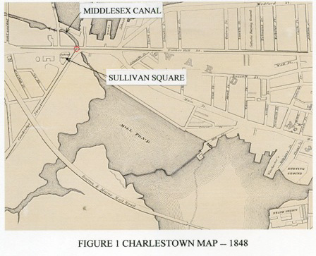
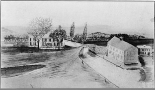
An 1848 map*, Fig. 1, above, shows the location of Sullivan Square which marked the southern end of the canal at Charlestown Neck, and near where the canal entered the mill pond. The water around the Neck has been filled in, and the new land that was created has since been covered with buildings and road ways, see Fig. 2, below, a modern map taken from the Internet.
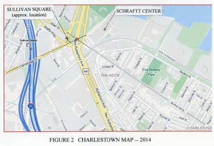 |
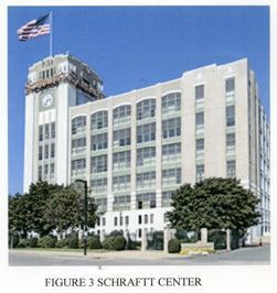 |
Today, the name Sullivan Square is best known as a stop on the Orange Line. The park that was named Sullivan Square has disappeared into a traffic circle and underpass. Fig. 1 shows that the intersection of lines drawn along Cambridge and Bunker Hill Streets on the 1848 map is near the location of Sullivan Square (park) and the dug end of the canal. This street intersection is used to locate Sullivan Square (park) on the modern map which also shows Cambridge and Bunker Hill Streets. It can be seen on the modern map that the disappeared Charlestown end of the canal and Sullivan Square (park) is in close proximity to the Schrafft Center, a large landmark, shown in Fig. 3, above. Maybe, we should consider saying that the Middlesex Canal’s southern end was near the location of the present day Schrafft Center, rather than an undistinguished traffic circle.
 |
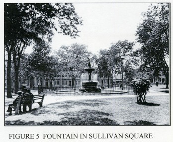 |
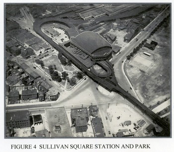
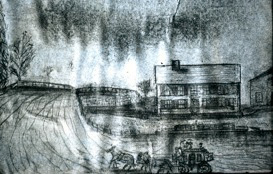
In a photo dating from 1929, see Fig. 4, above, Sullivan Square was about three quarters of an acre in size. The Charlestown station of the Boston Elevated Railway is adjacent to Sullivan Square in this figure. The fountain that was in the park is shown in Fig. 5, above.
*J Breen provided this map.
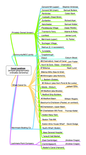
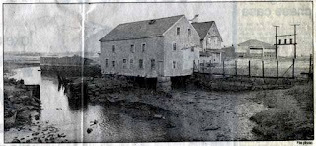
CANAL-SIDE LANDINGS
by Bill Gerber
Many of the products transported on the Middlesex Canal, e.g., timber and wood products, granite, farm products, etc., could be loaded somewhere near to where they were obtained or produced and often landed near their point of use. But to serve the public-at-large, as well as a number of private interests, Landings were built within or near most of the communities along the Middlesex and related canals and rivers.
 Landings typically consisted of a warehouse and a dock, with the dock equipped with a crane and/or other mechanical aids to facilitate the loading and unloading of boats.
The warehouse was simply a place to which goods could be taken to be shipped, where they would be held until there was boat-space available to move them, and from which shipped goods could be held until retrieved by their owners.
Shown in the diagram at right, the general locations of more than three dozen such Landings have been identified. These are arrayed geographically, north to south. A few of these were temporary sites, e.g., building sites, and some others are “place holders”, e.g., Cragie’s canals and Master’s canal that likely served multiple public and private interests. No doubt there were many more, for example, the collected rockremains of two such Landings can be seen upstream of the new bridge over the Merrimack, serving the Manchester NH Airport from the Everett Turnpike. Who built either of these or what cargos were shipped or exchanged there are yet to be determined.
At each of the publicly accessible Landings, an Agent was responsible for receiving and receipting for goods to be shipped, arranging for that shipment, or accepting shipped goods and arranging for pick-up by their intended recipients. Needless to say, the Agent was also responsible for the security of all goods entrusted to his care until properly shipped or distributed.
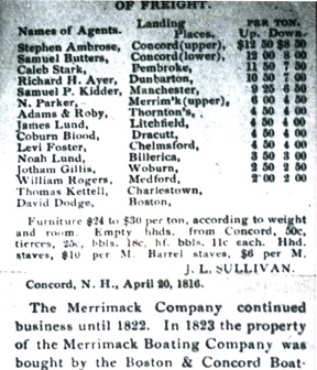
To the extent we know their names, the agents are shown in the advertisement, following, (and listed in the initial diagram) linked to the Landing for which they were responsible. Also noted are the per-ton fees for shipping to or from Charlestown or Boston from each point.
The ownership of Landings varied. The Middlesex Canal Company initially built and operated eight of them (i.e., the numbered Landings (#1 thru #8 in the diagram at right) to serve communities along the length of the canal. Actual construction took place within the first few of years of the canal’s operation. The main object of the proprietors was to get the business onto the canals.
Early on, three additional Landings, at Dracut, Tyngsborough and Nashua, were constructed cooperatively, meaning that each of the communities built the warehouse and the canal company built and equipped the dock. These were the first of the Landings to be built along the Merrimack River. The landing at Nashua was along the Merrimack, at the south side of the mouth of Nashua River, where a store was erected2. Many more Landings were constructed by private parties.
 Through service along the Middlesex Canal was initiated for passengers and light freight on August 22nd, 1804, when, Mr. Wardwell set out in the Packet Boat George Washington, from Beachum Landing in Charlestown bound for the head of the Canal in Chelmsford.3 [Beachum’s was located north of Landing #1, likely very near to the SW end of Beachum Street and today’s Sullivan Square. This Landing seems to have served Packet Boat operations almost exclusively.]
Some of the Landings served the public, while others served private interests. An example of the latter is Hunnewell & Gore, the glass factory in Chelmsford, through which Landing sand and fuel (probably copious amounts of charcoal and/or cord wood) were received and glass products were shipped. When the Middlesex Canal first opened, and before the canal company built its own Landing, it shared H&G’s private Landing.4
To extend shipping services across the Charles River to Boston a part of the Alms-house wharf was rented, a small store or office erected, and ways constructed for the more convenient loading of boats. A line of buoys and ropes was set up across the Charles so that boats could pass over against the wind and across the tide. [See TT 3/’08; “… Canal that Bisected Boston” Figures 1 & 2.]
|
Though sketchy, historical records suggest that John L. Sullivan and his brothers built and operated Landings in the many communities along the Merrimack and retained ownership and control of all of these. In addition, John L’s Merrimack Boating Company built one Landing north of Concord NH, and another at Rust’s Wharf in Boston; at the end of Pond Street, immediately upstream of the Charlestown Bridge.
The case of the Landings built by the Sullivans is an interesting one. Deeds from that era show that, beginning in 1806, almost a decade before the Merrimack was made navigable above Nashua, the Sullivan brothers bought about forty 50 to 100 acre tracts at a number of sites along the river. Quite likely, they built their Landings at several of these sites.
Because the level of water in the canal didn’t vary much, Landings constructed along the canal could employ docks built at ‘deck level’, i.e., at a level such that cargos could be loaded and unloaded laterally, as shown below in Louis Linscott’s painting of Abbott’s Landing. Abbott’s was a private Landing located near Woburn Center. It was a source of wood products for local builders, and quantities of lumber are stacked around the periphery of the Landing to reflect this. But Abbott’s also served area tanners with tanning bark (likely the bark of Oak and/or Hemlock trees), which was shipped measured in cords (4’ x 4’ x 8’ stacks, tightly packed). It may well be tanning bark that is being unloaded into the ox-cart on the left side of the building.
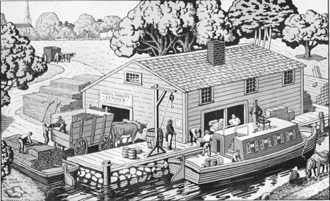 It is not clear why a Packet Boat is shown here, Packets served the business interests of the canal company and typically carried passengers and light freight to help cover the cost of that function. (Note its ‘motor’ refueling along the towpath, opposite!)
Although also built at “decklevel” at least one of the Landings built by the canal company, Chelmsford Landing (Landing #8) exhibited a considerably different configuration thus suggesting that perhaps all of the Company-built Landings were built that way. Thanks to glass-slide photos taken by Leon Cutler, in the 1930s, of historic materials he collected, we have two drawings of Chelmsford Landing, likely drawn by different artists, but both portraying the same structure and environs; these are shown below.
 For reasons yet to be determined, Chelmsford Landing was a two story building. Almost certainly the lower floor served as the warehouse, but it seems unlikely that cargos would have been lifted up to be stowed on the second floor. Could it be that the Agent and his family lived on the floor above? Surprisingly, no mechanisms are shown for loading and unloading boats.
Landings built along the river were quite different from either of the canalside structures discussed above. Located adjacent to a major bridge, the Landing shown below probably served Concord, NH. Because the level of the river could vary widely, the river-side warehouse was built level with or even above the top of the river bank, almost certainly to position them above high water during Spring freshets and floods. Because of this, boats were positioned directly below the Landing, but within its footprint, and loading and unloading was accomplished vertically.
 For the Landings for which we have historical information, the loading and unloading equipment was housed within and operated from the warehouse floor. According to an advertisement posted by John Sullivan, at least some of the river Landings were equipped with a “wheeled windlass”, apparently a smaller variant of the type of human or animal powered tredwheel cranes that were used in medieval times to lift stone and other heavy materials to build churches, castles and other large an durable structures.
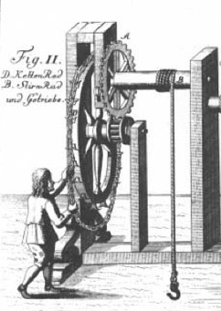
 The wheel from one such windlass, the Landing at Reed’s Ferry in Merrimack NH, was described to me by local resident Charles Mower as being about eight feet in diameter, but much too narrow to be a tredwheel, and with its outer circumference alternately studded at intervals with wrought iron “Ys”. These “Ys” would have served to guide a chain, or more likely a rope (given little evidence of wear on the “Ys”) to make the wheel easier for the operator to use. This description suggests that the configuration of the windlass, of which this wheel was a part, might have been similar to that shown.
 Regrettably, the Reeds Ferry wheel was left out in the weather for many years until it fell apart.
It is not clear what the arrangement was, but at least some of the Landings provided the means for farmers to kill, butcher and pack their livestock for shipping directly to market via the canal system. In 1805, John Sullivan, Agent for the canal company noted in one of his reports “how great the saving must be to bring down the cattle and hogs salted instead of driving them to the butchers’ stalls near Boston, and by the advantage of bringing all property for market directly to the capital, instead of landing it short of that place.”
And again in 1818 he observed “If the owner of cattle wishes to make the profits himself, on barreling his beef he finds a slaughter house, butcher and packers and salt at the landing.”
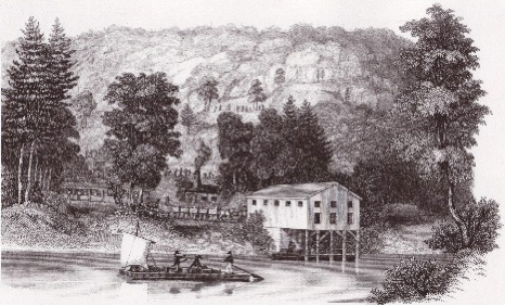 Shown in the figure at left is the Landing at North Concord, the scene taken from a stock certificate for a Granite and RR Company. It’s construction appears consistent with other known riverside Landings, but it was one of only two owned and operated by the Merrimack Boating Company. It was located by a bridge along a road north of Concord NH and, among others, apparently served the granite quarry at Rattlesnake Hill as one of its customers. A good bit of the granite used in the construction of buildings in Boston came from this quarry, notable among them the upper portion of the Faneuil Hall Marketplace.
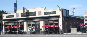
If you’d care to visit a canal-era Landing, one is known to have survived. Located in Nashua NH, where Main street crosses the Nashua River, it is somewhat unusual; it was constructed of brick and stone and, of course, it has been “repurposed” several times since the demise of the canal system. Shown below, today, it houses “The Peddler’s Daughter, Irish Pub and Restaurant”.
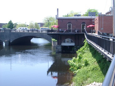
 If you do visit, while there, take a short walk downstream, along the Nashua River, and look back at the downstream side of the Landing, shown below, to see the water-level portal through which Luggage Boats, i.e. freighters, accessed the interior of the Landing for loading and unloading.
The Jackson Textile Mill, located along the Nashua Boat Canal downstream of the Nashua Landing, would likely have been supplied by boat with raw cotton. As such it would have had its own Landing.
 Also along the Nashua River, farther upstream, is the Nashua Manufacturing Company, a large textile mill which also had its own Landing and was initially supplied by canal boat with raw materials. The mill has since been “repurposed” to provide local housing.
Today, there is a very pleasant park along the Mine Falls Canal, which once carried water to power this mill. Although it was always a power canal, exclusively, with its adjacent three-mile walking trail it looks quite like a towpath canal.
Footnotes:
2 Fox, Charles J. History of the Old Township of Dunstable including Nashua, Nashville, Hollis, Hudson, Litchfield, and Merrimac, N.H. and Dunstable and Tyngsborough, Mass. (Nashua, 1846)
3 Baldwin Manuscripts, Baker Library, Harvard University
4 Lammers, Dorit: German Glass Blowers in Chelmsford, Red Mill Graphics, No. Chelmsford MA.
TOWN RIVER, TIDEMILLS AND THE QUINCY CANAL
Lifted from http://kupapalani.blogspot.com/2012/02/history-of-souther-tidemillquincy. html, the following information concerning the history of the Souther Tide Mill is transcribed from the - Quincy History, Winter 1981 issue, a publication of the Quincy Historical Society, by the late H. Hobart Holly. It is reprinted here with the permission of the QHS. [Ed.]
 Amid Quincy’s many historic sites, few reflect more important local history than the area where the old Quincy canal emptied into town river. Thousands of people pass the site daily on the Southern artery without noting the reminders of three industrial activities that played important roles in the story of Quincy.
In 1800 this area was largely saltmarsh and meadow into which a tidal arm of the town river extended up to the road to the ferry, shortly to become the Hingham and Quincy turnpike and now Washington Street. Into this tidal waterway, under a bridge for the road, flowed the town brook near which was the center of the settlement from 1634. Nearby on town river was the town landing, a most important place from the earliest days. The saltmarsh was itself a highly valued asset; people still relied heavily on salt hay.
Starting in 1802, Ebenezer Thayer (1768-1841), a merchant of Boston and Charlestown, shortly to be of Quincy, purchased about 39 acres of land between the road to the ferry and town river. On the river he built two wharves; the present Quincy Lumber Company wharf is their successor.
On June 23, 1806, the legislature passed an act authorizing Ebenezer Thayer to build a dam across town river “for the purpose of erecting a mill or mills on the same”, that he carried out this purpose is verified by mention of the mill pond when he sold his property in 1814 to David Stetson of Charlestown. The next year, Stetson sold the property to John Souther, Jr. who carried on the several industrial activities there; he operated a shipyard, a wharf, a grist mill, a saw mill and the canal lock.
John Souther, Jr. was well established in his family’s shipbuilding business in Hingham when he moved to Quincy in 1815 and built the handsome home still standing at 356 Washington Street. He and his son, John L [incoln] Souther, operated an active shipyard on town river for nearly fifty years, building many important vessels.
In addition to the shipyard, the Southers operated the two tide mills, a grist mill and close by to the last, a saw mill. Mill Street and Pond Street still commemorate this activity. The original grist mill burned and was replaced in 1854 by the building still standing over its old raceway as part of the Quincy Lumber Company yard. The machinery has long been removed but the rugged mill building construction survives.
A sidelight on the grist mill is of interest. In present Braintree, from the days when it was Monatiquot Village and then the middle precinct of old Braintree, there was a succession of mills on the farm and Monatiquot Rivers. Present Quincy, however, the original center and then the north precinct of the old town, is a distinct contrast. Here were operated just two stream-operated mills. The old town grist mill operated from 1640 to the 1850s on town brook at Fort Square where a millstone monument commemorates it. On Furnace Brook was John Winthrop, Jr.’s iron furnace of 1644 which ceased operation after a short time partly because of the inadequacy of the waterpower. Thus this area had to use tide power. In addition to the Souther mill, there were two earlier tidemills on Black’s Creek.
By the 1820’s, Quincy’s granite quarrying industry was reaching a status of importance and transportation of the heavy material was a major concern. Economical transportation was available on sloops and schooners suitable for the purpose - like some built by John Souther, Jr. - but getting the stone to tidewater and aboard the vessels presented a problem. The solution for the West Quincy quarries was the granite railway of 1826 which carried the granite to Bunker Hill wharf on the Neponset River. Concurrent with the establishment of the granite railway was the formation of the Quincy Canal Corporation to provide facilities for loading stone from the North Common or Quarry Street area on the granite sloops and schooners. The canal utilized the tidal portion of town river that extended up to present Washington Street.
On 26 January 1827, John Souther, Jr. Deeded to the Quincy Canal Corporation free passage through the dam which was erected by the act of legislature of 23 June 1806. Souther to have full use of the mill pond for his mills, the lock and abutments erected by the canal corporation shall be kept in order by them and no more than six inches of water from the mill pond shall be used for locking vessels. Thus it is explained how mills and a canal could operate on one set of tide gates.
The Quincy Canal operated for some years but, unlike the granite railway, it was not a financial success and its stockholders lost heavily. The graniteloading wharves, the tow paths, the mill pond and much of the waterway have long since disappeared; but remains of the abutments and tide gate structures can be seen today near the historic tidemill building.
In 1873 the Southers sold the shipyard properties and their wharf to Wilber F. Larkin who converted it to a lumber yard. In this business it has functioned for over a century under Larkin, then Benjamin Johnson and the Johnson Lumber Company and since 1912 the Quincy Lumber Company. John L[incoln] Souther sold the dam and mills to Johnson in 1888. Thus continues the long and important industrial activity on this site in historic Quincy.
Of further note, the brig Souther was built as a gold rush ship and launched in 1840 at Souther wharf next to the tide mills.
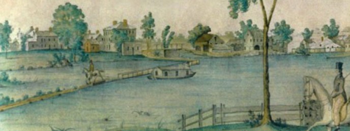
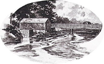
 Nameplate - Excerpt from a watercolor painted by Jabez Ward Barton, ca. 1825, entitled “View from William Rogers House”. Shown, looking west, may be the packet boat George Washington being towed across the Concord River from the Floating Towpath at North Billerica.
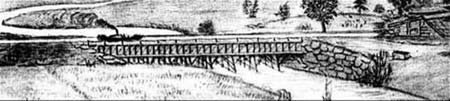
Back Page - Excerpt from an August,1818, drawing (artist unknown) of the Steam Towboat Merrimack crossing the original (pre-1829) Medford Aqueduct, probably on its way to service on the Merrimack River.
Estate Planning - To those of you who are making your final arrangements, please remember the Middlesex Canal Association. Your help is vital to our future. Thank you for considering us.
Museum & Reardon Room Rental - The facility is available at very reasonable rates for private affairs, and for non-profit organizations’ meetings. The conference room holds up to 60 people and includes access to a kitchen and rest rooms. For details and additional information please contact the museum at 978-670-2740.
Web Site - As you may have noted in the nameplate, www.middlesexcanal.org is the URL for the Middlesex Canal Association’s web site. Our webmaster, Robert Winters, keeps the site up to date, thus events and sometimes articles and other information will sometimes appear there before we can get it to you through Towpath Topics. Please do check the site from time to time for new entries. Also, the site now contains a valuable repository of historical information, all of the back issues of TT, and an index to all of the articles contained therein, can now be found there at http://middlesexcanal.org/towpath.
Back Issues - Fifty years of back issues of Towpath Topics, together with an index to the content of all issues, are also available from our web site at middlesexcanal.org/towpath. These are an excellent resource for anyone who wishes to learn more about the canal and should be particularly useful for historic researchers.
Towpath Topics is edited and published by Bill Gerber and Robert Winters.
Corrections, contributions, and ideas for future issues are always welcome.